Archive for the ‘Light rail transit (LRT)’ Category

h1

Downtown Austin Alliance Proposes Additional Downtown Station

16 April 2024
Wooldridge Square Station proposed by DAA, showing connectivity benefits. Source: DAA via Austin Transit Partnership.

By Lyndon Henry, Editor

In my December 18th ARN article, “Downtown Light Rail Plan Needs More Stations”, I explained the need to include additional downtown stations in Project Connect’s revised surface-routed light rail transit (LRT) plan, and specifically recommended adding stations on the Guadalupe St. alignment at Republic Square (W. 4th St.) and W. 10th St. (Wooldridge Square). As I noted, these proposals were developed via my discussions in the previous spring and summer of 2023 with ATP staff and technical advisory committee members; they were eventually presented in a June memo.

As it turns out, the Downtown Austin Alliance (DAA, a consortium of downtown businesses, real estate interests, developers, and related interests) had also perceived the need for at least one additional station – at Wooldridge Square, just as I have also recommended – and included a proposal for such within a memo dated 10 May 2023 to Austin Transit Partnership (ATP) Executive Director Greg Canally. (This is contained in ATP’s Austin Light Rail: Community Engagement Report, a document released publicly in May 2023.)

The Wooldridge Square Station proposal is shown in a graphic map appendix, labeled “Wooldridge Station Connectivity”, illustrating the additional coverage that the station would provide within a ¼-mile radius, and sites of key interest made more accessible by such a station (this is the head map-graphic at top of this post).

As I had pointed out in my own June 2023 memo, Project Connect’s revised plan for downtown was proposing “exceptionally long spacing between stations for a major dense central area, and I believe it is inconsistent with Best Practices ….” DAA’s memo seems to provide some corroboration for this assessment, while emphasizing the enhanced accessibility provided by a Wooldridge Square station:

As currently proposed, the distance between the Congress and 15th Street stations is approximately one mile. We recommend adding an additional station in the vicinity of Wooldridge Square and Sweatt Travis County Courthouse. This would lessen the distance between the Congress and 15th Street stations to less than half a mile and would provide much needed access to courthouses (federal and state), Austin Community College, Pease School redevelopment, Austin History Center, the Paramount and the Old Bakery. It would also facilitate east-west transfers to frequent bus routes at 7th/8th Streets, providing potential congestion relief at Republic Square.

For sure, DAA’s proposal to add a Wooldridge Station represents an important and crucial improvement for the planned downtown LRT alignment. So far, Project Connect and Austin Transit Partnership have presented this as a possible design “option”. Hopefully this will be accepted as a definite element of the plan.

But a Republic Square station is also essential for adequate connectivity and accessibility in Austin’s downtown. The case for this will be presented in a subsequent analysis to be posted shortly. ■

h1

Downtown Light Rail Plan Needs More Stations

18 December 2023
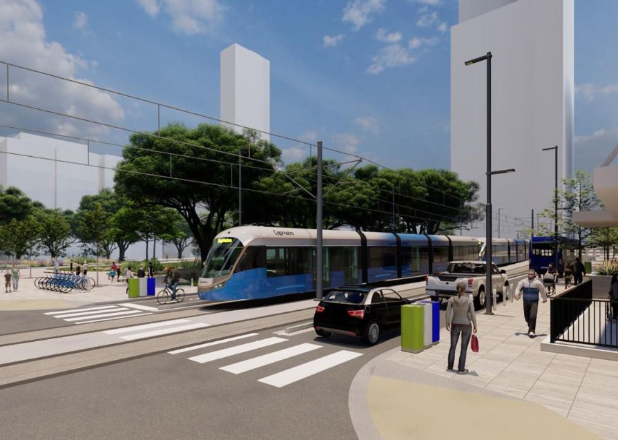
Simulation of LRT train on Guadalupe St. at Republic Square from Project Connect’s revised plan. But so far, the plan does not actually include a station at this crucial downtown transit hub! Source: ATP

By Lyndon Henry, Editor

Austin’s light rail transit (LRT) project continues to progress despite difficulties. The Austin Transit Partnership (ATP) and Project Connect (PC) planning team have so far been able to overcome serious legislative and litigational threats from public transport opponents. Equally important, they’ve managed to navigate through serious budget problems arising from design complications, external economic inflation, and other factors.

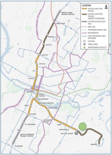
It’s a relief at last to have the workable (and hopefully entirely affordable) 3-branch light rail transit (LRT) system plan that ATP has adopted, shown in this map, publicly released this past May, which indicates proposed station locations as well as planned future line extensions:

ATP’s proposed Phase 1 surface LRT plan. Source: ATP

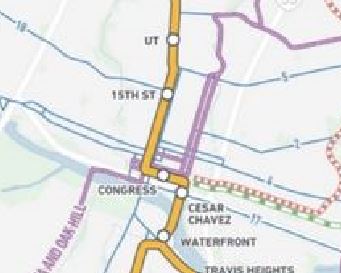
The revised downtown route is a surface alignment following several streets: Trinity St., 3rd St., and Guadalupe St. However, in discussions this past spring and summer with ATP staff and technical advisory committee members, I called attention to a major concern with respect to the small number of stations – just three – to serve both Downtown and the Capitol Complex – i.e., two-thirds of Austin’s critically important Central Area. All three proposed station locations – Cesar Chavez, Congress, and 15th St. – can be seen on this closeup from the map:

Closeup of LRT map with proposed downtown stations (Cesar Chavez, Congress, 15th St,)

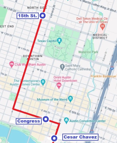
This deficit in stations results in a serious problem of inadequate station spacing in this key activity center complex. In particular, there is a 14-block gap (in line length) between the proposed Congress station (located on 3rd St. west of Congress Ave.) and the proposed 15th St. station (on Guadalupe). The route distance (per Google Maps) for this gap between these two stations measures 5,633 feet. That’s 1.1 mile, or 1,717 meters, between these stations.

The following more detailed map graphic, created from Google Maps, facilitates a more accurate assessment of the proposed LRT route and stations within the grid of streets, blocks, and major landmarks, and a better visual sense of the lack of stations along Guadalupe St., resulting in the sizable gap between the proposed Congress and 15th St. stations.

ATP’s proposed downtown LRT route and stations. Source: LH, via Google Maps

This is an exceptionally long spacing between stations for a major dense central area, and it appears to be inconsistent with Best Practices as exhibited by downtown route configurations in peer cities, particularly with central-city surface alignments, such those in as Portland, San Diego, Sacramento, Phoenix, Minneapolis, Dallas, Houston, Denver, Salt Lake City, and others, where spacing typically ranges from 3 to 8 blocks. In fact, I can’t immediately think of any other light rail system in North America with a station spacing that wide in the heart of its downtown.

Transportation consultant Jarrett Walker has discussed the stop-spacing issue on his website, HumanTransit.org: Basics: The Spacing of Stops and Stations.  As Walker notes, “… transit planners generally observe that the walking distance that most people seem to tolerate — the one beyond which ridership falls off drastically —  is about 400m (around 1/4 mi) for a local-stop service, and about 1000m (around 3/5 mi) for a very fast, frequent, and reliable rapid transit service.”

Here, Walker is discussing stop-spacing for a city as a whole. However, it’s crucial to consider the particular factors in play regarding the spacing of stations and adequate access in a downtown or other densely concentrated high-activity area. Given the dense mesh of downtown street structure, a circular radius yardstick doesn’t seem adequately applicable – transit users can’t walk in straight-line radii between worksites and transit stations, they must follow the zig-zag street configuration, which significantly increases total access distance. Plus additional time spent waiting at traffic lights must be taken into account.

Real access time in minutes would probably be a better comparative measure of ease of access. And it’s not just a matter of convenience. This means that excessively wide station spacing in a downtown may impair access, discourage use of the transit service, and thus significantly reduce ridership. It also imposes extra difficulty for the elderly and mobility-challenged. Potentially the problem could also damage public goodwill.

While the Project Connect team has expressed concern about steep gradients on Guadalupe at 5th St. and several blocks north that affect station construction, I note that industry guidelines are not rigid but do allow design to follow existing street gradients where this can be done consistently with safety and Best Practices. (Reference: TCRP Report 155, 2nd Ed. 201; U.S. Access Board, Accessibility Standards.)

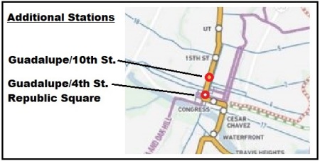
Taking into account these considerations, to remedy this (so far publicly presented) 1.1-mile gap in downtown LRT station spacing, on 28 April I proposed that at least two additional downtown stations on Guadalupe St. be added to ATP’s revised surface LRT plan. As illustrated in the small amended map segment presented below, these include a station at 4th/Guadalupe to serve the existing transit hub at Republic Square and the lower west side of downtown, as well as a station at 10th/Guadalupe, intended to improve accessibility to the north end and upper west side of downtown, including the Travis County Courthouse, many legal and professional offices, and the Austin History Center.

Proposed additional downtown stations. Source: LH

ATP personnel indicated that they were considering these proposals, and the broader possibility of adding more downtown stations to the revised LRT plan. So far, no changes have been publicized. ■

h1

Success at last! Austin votes to install light rail system

30 November 2020

Campaign poster for Austin’s Proposition A transit ballot measure, showing LRT trains, with annotation after Nov. 3 victory. ACTPAC graphic, annotated by ARN.

It’s taken over 40 years of proposals, planning, debate, defeats, and delays, but finally, on 3 November 2020, despite the daunting challenges of the global Covid-19 pandemic and massive economic crisis, 58.3% of Austin voters approved a $7.1 billion major transit upgrade and expansion to the Capital Metro (transit authority) system, including a New-Start electric light rail transit (LRT) system for the city. For the initial starter system, two lines are proposed, intersecting in a downtown subway tunnel. About 45% of the capital funding is expected to come from the U.S. Federal Transit Administration. To cover the local 55% share, even in these hard times, voters okayed a modest increase in the local property tax ($0.0875 per $100 valuation).

At long last, this amazingly successful vote redeems the very narrow failure of Capital Metro’s LRT vote in 2000. While that plan received a majority of City of Austin votes, it failed by less than 2000 total votes in the more suburban and rural parts of Capital Metro’s service area. In contrast, the 2020 ballot measure involved City of Austin voters (and City bonding authority) only, receiving a comfortable majority margin of eight percentage points. Ironically, the Orange Line component of the LRT plan just approved is, in large part, a replication of the central North-Lamar-to-South-Congress alignment proposed in the 2000 plan!

This latest vote, for the ballot measure identified as Proposition A, also approved not just light rail, but a massive increase in Austin’s overall transit system, including an upgrade of the bus network with improved service frequency plus new “bus rapid transit” (more the “light” variety than the full, capital-heavy type); conversion to an all-electric bus fleet; a citywide on-demand pickup/circulator bus/van system; and an upgrade and expansion of the MetroRail light regional railway service, operated with diesel-multiple-unit (DMU) rolling stock compliant with Federal Railroad Administration “heavy” mainline railroad standards. In the map below, the proposed new LRT lines are shown in orange (gold) and light blue; the “BRT” lines are purple; the existing MetroRail line is red, and the new MetroRail line is green.


Map shows system plan of public transit system approved by Austin voters on Nov. 3rd. Graphic: Project Connect.


The basic anchor of the planned LRT system is the Orange Line, which will create a powerful public transport backbone along the crucial North Lamar-Guadalupe-South Congress travel and urban development route – Austin’s heaviest-traffic, highly developed, and most centrally positioned major local corridor. For background, the importance of this corridor, and the decades of intensive, agonizing public interest, studies, hopes, indecision, deliberations, and proposals concerning it, are described in ARN’s 2015 report, Long saga of Guadalupe-Lamar light rail planning told in maps. For additional background on the importance of this corridor, also see: Latest TTI data confirm — Guadalupe-Lamar is central local arterial corridor with heaviest travel and Guadalupe-Lamar urban rail line would serve 31% of all Austin jobs

The initial alignment of the Orange Line is planned to stretch from the North Lamar Transit Center (NLTC) at U.S. 183 and North Lamar, southward down Lamar, then Guadalupe, and into a downtown subway with a major underground hub at Republic Square (W. 4th St.). Continuing south, the subway is currently proposed to extend under the Colorado River (locally known as LadyBird Lake). Emerging back to the surface, it would proceed in the median of South Congress southward to a provisional terminus at Stassney Lane. The longer-range plan entails extending this line north to Capital Metro’s transit hub at Tech Ridge, and southward to a new multi-modal center at Slaughter Lane/Southpark Meadows.

The Blue Line, to be developed concomitantly, would interline with the Orange Line from the NLTC into the downtown subway. At the Republic Square junction, the Blue Line would branch eastward, running in its own short tunnel a few blocks to a proposed Downtown Station. Emerging from the subway, it would then head across the river on a new multi-modal bridge. It would then turn eastward again, following East Riverside Drive and other alignments to reach a terminal at the ABIA Airport

Preliminary tunnel construction plans have envisioned using the cut-and-cover method. However, geometric and engineering constraints and subsurface conditions may favor the use of deep boring. For rolling stock, planning has assumed peak four-car consists of articulated electric LRT vehicles. For the Orange Line alone, ridership in excess of 85,000 per day has been forecast for the year 2040 in systems-level planning.

Vigorous grassroots community involvement has been key to the successful outcome of Austin’s long-recognized need for urban rail. A persistent campaign spearheaded initially by the Texas Association for Public Transportation in the 1970s, joined in the 2000s by the Central Austin Community Development Corporation (CACDC), gradually mobilized a coalition of local activists and organizations to maintain an unrelenting public focus on the need for an LRT system anchored in the North Lamar-Guadalupe-South Congress corridor. To its great credit, Capital Metro’s planning program, Project Connect, mounted a massive community outreach program, reaching tens of thousands of individuals throughout the city, and created the Project Connect Ambassadors Network (PCAN), involving dozens of key community activists who met monthly to interact with the official planning team, inputting ideas and helping shape the development of the final plan.

During the election campaign the official campaign leadership and planning team, organized as Transit for Austin and the Mobility for All PAC, managed a well-run, aggressive, consistent, and effective public involvement and media campaign that certainly played a crucial role in achieving this victory. This was bolstered by other community efforts, particularly the Austin Coalition for Transit PAC (ACTPAC).

All in all, Austin’s LRT New Start achievement is an amazing leap forward for a concept that started with the vision and aspirations of a few community activists in the 1970s. These early dreams and hopes led them to catalyze the effort to create a transit authority in the mid-1980s; to persevere through the narrow LRT plan defeat in 2000; to inspire and attract additional community support; to reject the flawed plan in 2014; and finally to soldier on to an astonishing success for a widely supported multi-line LRT system in this otherwise catastrophic year.

h1

Project Connect’s Orange Line operating cost assumptions seem to fail plausibility test

3 December 2019

Cover of Project Connect’s O&M cost methodology and assumptions report. Screen capture by ARN.


This analysis has been adapted and revised from comments originally posted to the #ATXTransit listserv by Lyndon Henry, a technical consultant to the Light Rail Now Project and contributing editor to Austin Rail Now (ARN).

For approximately the past year, Capital Metro’s planning program, Project Connect, has been analyzing two travel corridors for major high-capacity rapid transit investment – the Orange Line (basically following the North Lamar-Guadalupe-South Congress corridor) and the Blue Line (roughly following the Red River-San Jacinto/Trinity corridor through downtown and then the Riverside corridor out to ABIA). A federally required Alternatives Analysis has been undertaken by a consulting team led by AECOM to recommend a modal system choice between light rail transit (LRT) and bus rapid transit (BRT), as well as other features and service characteristics such as vehicle types, station locations, alignments, and the capital costs and operating and maintenance (O&M) costs of each alternative.

Recently the agency released as public information selected details, including methodological procedures and cost assumptions. These have prompted scrutiny by community professionals and activists, particularly in regard to important O&M cost assumptions. In some cases these assumptions have been called into question.

For example, a 13 November posting by research analyst Julio Gonzalez Altamirano (JGA) on his Informatx.org website presented an extensive critical analysis. This resulted in two major findings:

• Project Connect’s BRT revenue hour cost estimate is lower than the national average by 26%. Project Connect does not explain its rationale for the methodological choices that lead to the lower rate.

• Project Connect’s use of a flat passenger car revenue hour rate to calculate LRT costs obfuscates the economies of scale associated with multi-car LRT trains. This is a change from the approach taken by Project Connect in 2013-2014. The new method makes Blue Line LRT appear more productive and Orange Line LRT less productive than an approach that recognizes the cost advantages of LRT scale (e.g. multi-car trains). Project Connect does not explain the rationale for the methodological switch or why its current approach will generate more accurate estimates.

These findings are broadly in line with the results of ARN’s own research into Project Connect’s O&M cost methodology and resultant assumptions, particularly with respect to the Orange Line surface LRT and BRT alternatives. Our analysis relied primarily on data for appropriate peer systems to Austin, reported in the Federal Transit Administration’s National Transit Database (NTD).

Basically, we find that Project Connect’s cost per vehicle-hour assumptions consistently seem to overestimate LRT costs by more than 51% and underestimate BRT costs by over 26%. The bottom-line result is to skew Project Connect’s O&M cost assumptions as much as 70% in favor of the BRT alternative. This produces a relatively huge disparity in evaluating the alternatives, and challenges plausibility. Details of our analysis, plus conclusions and a recommendation, are presented below.

Methodology

Operational configurations and service cycles affect O&M costs, including costs per vehicle-mile. ARN’s methodology has differed somewhat from JGA’s. Most importantly, from the 2017 NTD (latest currently available), ARN selected seven new-start LRT “peer” systems based on both urban characteristics and surface-running alignment and operational configurations that we judged to more closely match those of Austin and the proposed Orange Line surface LRT: Denver, Houston, Minneapolis, Phoenix, Portland, Sacramento, Salt Lake City. Although some have urban or suburban branches on exclusive alignments, all have significant segments in urban streets.

These seven systems have been selected in part for their urban, extensively on-surface, and in some cases predominantly street-routed character (similar to the alignment proposed for Austin’s Orange Line). Generally comparable urban population and density were also an important factor. As state capitals, Denver, Sacramento, Phoenix, Salt Lake City, and St. Paul (included in the Minneapolis-St. Paul system) also make good peer cities for Austin. Other new-start LRT systems that might have some sections on city streets but operate predominantly over extensive regional lines or grade-separated alignments were not considered as fully comparable cost models.

In contrast to our peer-systems approach, Project Connect states that, via its own methodology, “O&M unit costs for LRT service reflect a weighted national average cost per revenue hour ….” [Orange Line Operating and Maintenance Costs, 30 Oct. 2019] Apparently these costs are based on NTD data.

However, if Project Connect calculated its average from national data of all LRT systems reported in the NTD, this would have included a widely disparate collection of O&M and other data, much of it starkly dissimilar to Austin’s demographics and proposed LRT operational conditions. For example, legacy systems (remnants of historic surface electric railways dating back to the late 19th or early 20th century) such as those in Boston, San Francisco, Newark, and Pittsburgh retain a variety of older operating characteristics (e.g., onboard fare collection by train operators) that drive their vehicle-hour costs significantly higher than the average of modern new-start systems.

Other problems with such an indiscriminate approach include differences in alignment engineering configuration. Accordingly, we assessed some modern new-start LRT systems to be less suitable O&M vehicle-hour cost models for Austin’s proposed street-routed LRT Orange Line, including several we excluded particularly because of their proportionately more extensive subway and elevated segments: Buffalo, Los Angeles, St. Louis, Dallas, Seattle.

Nevertheless, despite what appear to be serious weaknesses with its own methodological assumptions, Project Connect has calculated an O&M cost per vehicle-hour of $284.15 (2017) for its Orange Line LRT surface alternative.

As regards BRT, in our judgement eight of the operational configurations of BRT systems reported in the 2017 NTD seemed to conform to the Orange Line BRT surface operating proposal, and can be assumed to represent peer systems with respect to Austin. These BRT services – operating in Cleveland, Eugene, Ft. Collins, Grand Rapids, Hartford, Kansas City, Los Angeles, and Orlando – thus provide an appropriate basis for comparing and evaluating Project Connect’s Orange Line LRT and BRT scenarios. New York City was excluded because its exceptionally high density, population size, and vast multi-model transit system are far out of proportion to Austin’s conditions. Boston’s disconnected system, partly operating as a trolleybus subway, also seemed inappropriate as a peer system. Likewise the Roaring Fork Transportation Authority’s operation, a basically rural system more closely resembling a regional or intercity motor coach service than an urban transit service, was also excluded. Data for the eight peer systems were used to develop metrics for comparison with Project Connect’s assumed cost inputs.

For 2017 O&M cost per vehicle-hour for Project Connect’s Orange Line BRT surface alternative, Project Connect’s own assumptions (based on information from CMTA and NTD) amount to an effective estimate of $119.10, as JGA has converted from Project Connect’s 2028 estimates.

To calculate current national averages and metrics for comparison, we’ve totaled current costs and other relevant values for the target LRT and BRT peer groups from National Transit Database (NTD) profile data, then calculated averages from those totals. All costs discussed are presented in 2017 dollars.

Results

LRT: Average actual 2017 O&M cost per vehicle-hour for the seven peer LRT systems is $187.52, 34.0% lower than Project Connect’s assumed cost of $284.15 for the Orange Line surface LRT option.

BRT: Average actual 2017 O&M cost per vehicle hour for the eight peer BRT systems is $162.23, 36.2% higher than Project Connect’s assumed cost estimate of $119.10 for the Orange Line surface BRT option.

LRT vehicle-costs/hour are typically higher than for buses mainly because LRT cars are larger and stations are also usually larger, creating higher maintenance costs. (These characteristics generally stem from LRT’s higher capacity and propensity to attract greater passenger volumes.) The ratio of actual NTD-reported peer-system LRT to BRT costs is 1.16. However, Project Connect’s cost assumptions amount to an LRT:BRT ratio of 2.39 – in other words, approximately twice the cost ratio in actual operating experience. The disparity between Project Connect’s estimates and costs experienced in actual operations is illustrated in the graph below.


Graphic illustration of disparity between Project Connect’s O&M unit-cost estimates and actual reality of costs experienced by actual operations of comparable peer LRT and BRT systems. Graph: ARN. (Click to enlarge.)


Conclusions and recommendation

Project Connect’s assumption for cost per vehicle-hour appears to substantially underestimate BRT and overestimate LRT – and this has dramatic consequences for the agency’s overall cost model results, seemingly skewing the evaluatory process and calling into question the plausibility and validity of the agency’s O&M cost analysis. The table below, presenting Project Connect’s comprehensive O&M cost calculations for the Orange Line alternatives, illustrates how the differential in O&M cost-per-vehicle-hour estimates translate into enormous differences of tens of millions of dollars in annual O&M cost assumptions.


Table of O&M cost calculations from Project Connect’s report. Screen capture by ARN. (Click to enlarge.)


We would strongly recommend that these assumptions and the overall O&M analysis of these alternatives be reviewed and revised – particularly by basing cost estimates on appropriate peer systems relevant to the LRT and BRT alternatives proposed by Project Connect for the Orange Line.

h1

Austin Coalition for Transit supports light rail transit for proposed Orange Line

26 November 2019

ACT backs light rail for Orange Line. Graphics: ACT logo, Project Connect map.


The following is a media release issued by Austin Coalition for Transit (ACT) on 1 October 2019. Austin Rail Now, a participant in the ACT coalition, supports this policy statement. The statement has been slightly reformatted and edited for website publication.

Press Release:

Tuesday, October 1, 2019

Subject:

Austin Coalition for Transit (ACT) Issues Statement Supporting Light Rail for the Orange Line

Contact:

[Provides names and contact information for: Andrew Clements, Dave Dobbs, Roger Cauvin, Lyndon Henry, Steven Knapp, Roger Baker, Scott Morris, Gabriel Rojas, Mike Wong]

Today marks the one year anniversary of the release of the draft Project Connect Vision Map. It is an appropriate time to discuss some of the benefits an investment could bring to the people of our city and to the region as a whole.

Background

On October 1, 2018, a draft Project Connect Vision Map was released, and the Capital Metro Board went on to adopt an amended Project Connect Long-Term Vision Plan on December 17th. Two high capacity rapid transit corridors, the Orange Line and the Blue Line, were advanced for further study. A Federal Transit Administration (FTA) alternatives analysis has been underway to recommend modes or vehicle types, station locations, street alignments and service characteristics. Transit advocates have participated in this process, and we thank the agency for its public engagement.

Project Connect Orange Line: Unique Purpose and Potential

► The 21-mile Orange Line will be the north-south spine of Austin’s transit system. It will run in the Guadalupe-North Lamar and South Congress corridors between Tech Ridge and Southpark Meadows and may be served by an east-west grid of timed-transfer bus routes.

► The purpose of the Orange Line is to increase affordable, sustainable mobility and create economic opportunity for all, especially for the working class, people of color and the most economically vulnerable.

► The Orange Line will greatly increase the number of people who can move through the region’s core without the hindrance of congestion.

► The Orange Line will catalyze station-area economic development and include affordable housing developments for diverse economic groups to address the acute housing shortage in Austin for lower and middle-income families and individuals.

► Station-area development will also add to the commercial tax base, generating revenue for the City and Capital Metro that can be used to help pay for the costs to operate and maintain a Light Rail Transit system.

► As a successful starter line of a new transportation system, the Orange Line will improve daily life for a significant percentage of the region’s population and unify the city for generations to come.

Why Austin’s Orange Line Needs Light Rail

► The vehicle or mode of transit for this corridor has not yet been finalized, but strong current and future ridership demand in Austin’s most active transit corridor make Light Rail the most appropriate mode or vehicle choice.

► Light Rail offers large-vehicle capacity with speed to meet this ridership demand. The largest Bus Rapid Transit (BRT) vehicles are too small and slow and require wider lanes. The current 60’ MetroRapid BRT buses are overwhelmed by the number of riders even now.

► Orange Light Rail will attract more riders than buses, and use narrower lanes, maximizing the return on the public space required. Since 40% of Orange Line riders are expected to transfer from buses, this attraction factor will benefit the whole system.

► Orange Light Rail will have the capacity and frequency to move large volumes of people safely, reliably and comfortably within our constrained corridors.

► Orange Line Light Rail would serve the highest concentration of employers in the region and offer all people, including those who are economically disadvantaged, the ability to quickly get to well-paying jobs.

► Orange Line Light Rail will increase freedom and economic opportunity for students and the working class by reducing car dependency, maximizing the number of people who are able to live without the expense of a car.

► Orange Line Light Rail will maximize the ridership potential in the corridor, accelerate development of the transit system, and maximize the environmental benefits and human capital return on the investment.

Feasibility and Opportunity

► Orange Line Light Rail has the potential to pay for itself by delivering the highest return on investment (ROI) and will allow tax increment financing (TIF) in station areas to pay for the operation of the system. It will be a catalyst to invigorating and creating rail stations that are great urban places scaled to the pedestrian. Residential taxpayers will benefit from the new commercial tax base over time as a greater portion of city, county and school district property taxes will be covered by new commercial property in downtown and station areas.

► Orange Line Light Rail will efficiently scale to meet passenger growth, reducing Capital Metro’s per-passenger operating costs for each new rider as total system ridership grows over the years.

► Effective high capacity rapid transit requires dedicated transitways. The Orange Line is aligned with the Austin Strategic Mobility Plan (ASMP) allowing for dedicated transitways on Guadalupe, North Lamar and South Congress. This plan reduces car dependency, calling for a mode shift toward high capacity transit and active transportation. These goals will not be reached without good high capacity transit that people actually want to ride and adopt into their daily lives. Once dedicated transitways are built, it will be easier to find political support to retain and defend them with Light Rail than with buses.

► Outside the immediate Orange Line station areas, the City of Austin should consider developing transit-related land use policy to protect the vulnerable populations of North Lamar and South Congress by preserving their contributions and culture, reversing displacement and safeguarding existing affordable housing. Extending north of US 183 into the Rundberg area, the Orange Line will connect a dense and transit-dependent, multi-cultural population to work and play opportunities in other areas of the city.

► The 21-mile Orange Line runs parallel to IH-35 and Mopac and would serve as a bypass to help take pressure off highways by adding people-moving, time-certain mobility capacity for our growing region. Tech Ridge and Southpark Meadows are ideal transfer points for regional commuter buses, large park and rides or sites for affordable housing. Combined with the Red Line connection at Crestview, the Orange Line will give Central Texas commuters real alternatives to IH-35, Mopac and Hwy 183 congestion.

► Linking the neighborhood, town, and regional centers along the Orange Line will serve to activate the vision of the Imagine Austin centers concept by providing necessary transportation infrastructure for these locations.

► The Orange Line should be largely built on the surface to improve station access, maintain cost effectiveness, and keep the project affordable for the taxpayers of the City of Austin. Expensive underground tunneling and elevated segments must be minimized to keep the project competitive for federal capital grant funding.

► On narrow streets, other cities have met this challenge and avoided expensive tunneling or elevation by routing one direction of track down a parallel street, removing the center catenary pole, using curbside stations or purchasing right of way.

► The Orange Line and Blue Line need an interconnection that would allow riders to change lines seamlessly. Both the lines need to share at least one common station. The connector on 4th Street proposed by Project Connect between the Convention Center and Republic Square effectively splits the Blue Line in two. Blue Line passengers need a direct way to access Republic Square. It’s the city’s busiest transfer center and major point of convergence of express, local and MetroRapid buses, as well as a potential interconnection to the Orange Line.

About the Austin Coalition for Transit

Rooted in decades of advocacy, ACT is a coalition of individuals and non-profit organizations. ACT works collaboratively and inclusively to conduct a nonpartisan, equity-based, politically honest and technically accurate discussion about transit and its interrelated policy areas. ACT is independent of any agency or governmental body, and it works to ensure the voice of transit users are heard in transit planning.

Follow the Austin Coalition for Transit on Twitter for updates: @AustinTransit

h1

Why light rail transit is crucial for the Orange Line corridor

28 June 2019

A logical and affordable first step to actually implement a bona fide “high-capacity transit” system in the Orange Line corridor would be a 6.2-mile LRT starter line from US183 to downtown. Map: David Dobbs.

Commentary by David Dobbs

This commentary has been adapted, edited, and slightly expanded from original comments submitted to the Federal Transit Administration in response to Early Scoping for Project Connect’s Orange Line “high capacity” corridor (North Lamar-Guadalupe-downtown). David Dobbs is Executive Director of the Texas Association for Public Transportation and publisher of LightRailNow.org.

Austin, Texas is a line village whose principle population centers are caught between two major north-south freeways that are rapidly approaching maximum capacity and cannot be meaningfully expanded. The Texas Transportation Institute (TTI) states that failure to adequately address Austin’s future mobility in the IH-35 corridor will essentially shut down economic growth by 2035. [1] This approximately 21-mile-long, one-to-three-mile-wide ribbon of urban population has only one continuous north-south travel corridor that can provide sufficient mobility for future residents – and then only if a well-designed electric urban light rail transit (LRT) line is constructed as a surrogate/alternate to IH-35 from Parmer Lane to Slaughter Lane, primarily routed via North Lamar, Guadalupe, and South Congress

This concept – basically, an elaboration of the Orange Line sketched in Project Connect’s Long-Term Vision Plan – is summarized in the linked 5-doc_Dobbs_Objective-2030-Basic-Concept page (PDF). Constructed as surface-running LRT (e.g. Phoenix, Houston, etc.), revenue service could begin in 2030. With a 17 mph average speed, a cross-platform transfer point with the Red Line at the Crestview Station, and major park & ride facilities at each end, such a line could plausibly carry as many as 100,000 daily rider-trips by 2035. Running through the densest sectors of the city, it would serve as a template for dense, mixed-use transit-oriented development (TOD), while at the same time providing excellent access to outlying areas sans the use of automobiles. We estimate the cost of this 21-mile Orange Line at approximately $2 billion in 2019 dollars, a fraction of the cost of expanding IH-35 (see map below).

LRT in Orange Line corridor could link Tech Ridge on the north end to Southpark Meadows on the south. Map: David Dobbs.

As the Objective 2030 Basic Concept page also suggests, a first step toward this 21-mile central route could be a much shorter initial starter line (at substantially more modest cost). Illustrated in red on the map (and in the map excerpt included at the top of this post) is a 6.2-mile Minimum Operable Segment running from the North Lamar Transit Center (at US183) on the north end, south via N. Lamar and Guadalupe (and Lavaca) to a south terminus at W. 4th St. downtown.

The Austin community has spent more than $30 million in planning money over the last 40 years trying to get this essential transportation element built here in the Texas capital – see, for example, FTA’s summary of the 2000 LRT plan. [2] Unfortunately, with mobility worsening and the pace of critical urban decisions speeding up, time is running out. We simply cannot wait for some hypothetical new technology to be developed and become available at some undetermined date in the future. Light rail is the proven alternative world-wide.

References

[1] Mobility Investment Priorities Project Long-Term Central Texas IH 35 Improvement Scenarios August 2013 pp 58-61
http://tti.tamu.edu/documents/TTI-2013-18.pdf

[2[ FTA New Starts/Small Starts Austin, Texas/Light Rail Corridors (November 1999-& 2000)
https://austinrailnow.files.wordpress.com/2014/05/fta_austin-texas-cmta-light-rail-corridors-new-starts-nov-1999_.pdf

h1

Capital Metro strikes three blows against Lamar-Guadalupe light rail

31 May 2018

Graphic: Grace in the city

In a post this past February 28th, we reported on a surprising development coming from Capital Metro’s Project Connect planning process – the “conceptual” proposal of a 21-mile predominantly linear north-south light rail transit (LRT) corridor, running from Tech Ridge in North Austin, through the central heart of the city, to Slaughter Lane, near the Southpark Meadows area, in South Austin. The proposal particularly extolled the merits of a 12-mile-long segment, through the Lamar-Guadalupe corridor, from Tech Ridge to downtown.

After over four decades of indecision, missteps, and delay, it seemed like the transit agency (and city leadership) might, amazingly, have turned a corner. Could this actually mean that, at long last, Capital Metro and Austin’s top leadership were prepared to move ahead with a plausible, workable light rail plan – implementing a long-awaited leap forward in urban mobility – for the city’s most important central corridor?

Unfortunately, no. Slightly over a month later, Capital Metro reversed itself, withdrew the LRT proposal, and reverted to the familiar decades-long pattern of indecision, confusion, dithering, and delay that has gripped Austin like a curse.

Instead of an actual, specific project for a new light rail system, with a starter line from Tech Ridge to Republic Square downtown, the proposal had dissolved into the clouds, becoming just another line on a map of “perhaps something, some day”. To explain the retreat, planning was now described as “mode agnostic” – in other words, reverting back to a kind of official daydreaming, without any modes (the things that people would actually ride) identified to define a real-world project.

Almost exactly a month later, Capital Metro’s board made another fateful decision. Whereas mode-specific recommendations from the Project Connect study were scheduled for June, the board delayed that back to late in the fall (or perhaps winter) – far too late to put any kind of actual, mode-specific project (such as the previous LRT proposal) on the November ballot for possible voter approval of bond funding. (At best, this would now delay voter approval of any hypothetical project until the 2020 election cycle.)

A third blow against LRT in the Lamar-Guadalupe corridor was struck on May 8th, when the Capital Area Mobility Planning Organization (CAMPO) approved a Capital Metro-sponsored plan (originally submitted Jan. 19th) to overhaul the N. Lamar Blvd.-Airport Blvd.-MetroRail intersection (adjacent to the Crestview MetroRail station) with a design – exclusively focused on accommodating and facilitating motor vehicle traffic, rather than public transport – that would impose enormous obstacles to LRT on North Lamar. Currently, community activists and urban rail advocates are endeavoring to prompt a redesign of this project.

For decade after decade, the Austin community has agonized, writhed, and wailed over its steadily mounting mobility crisis. Hundreds of miles of lanes and roads have been built and rebuilt, and even more vigorous roadbuilding is currently underway. Yet the mobility crisis continues to worsen – for many motorists, driving around the urban area increasingly feels like trying to swim through solidifying mud. Or, alternatively, slogging through a battlefield ….

Repeatedly, the need for light rail has been affirmed. (See «Long saga of Guadalupe-Lamar light rail planning told in maps».) As we pointed out in a March 2015 post, “For two and a half decades, local officials and planners have explained why urban rail — affordable light rail transit (LRT), in Austin’s case — has been an absolutely essential component of the metro area’s mobility future.” («Austin’s urban transport planning seems struck by catastrophic case of amnesia and confusion».)

Capital Metro designated LRT in the Lamar-Guadalupe corridor as the region’s Locally Preferred Alternative in 1989. In 2000, Capital Metro hastily placed LRT on the ballot – but, in a poorly organized election campaign, it was defeated in the overall service area by a tiny margin (although it was approved by Austin voters). In 2014, another LRT plan was presented to Austin voters under the slogan “Rail or Fail” – but, proposed for the ridiculously weak Highland-Riverside corridor, the plan was resoundingly rejected. (See «Austin: Flawed urban rail plan defeated — Campaign for Guadalupe-Lamar light rail moves ahead».)

Time and time again, Austin has demonstrated that it’s the national poster child for chronically muddled urban mobility planning. In a January 2015 post, we warned that “Austin – supposedly the most ‘progressive’ city in the ‘reddest’ rightwing state of Texas – has a distinctive (read: notorious) reputation for dithering, dallying, and derailing in its public transport planning ….” («Strong community support for Guadalupe-Lamar light rail continues — but officials seem oblivious».) As our previously-cited March 2015 post went on to observe: “The devastating befuddlement of Austin’s official-level urban transportation planning … has been nothing short of jaw-dropping.”

Will Austin, and Capital Metro, ever manage to break out of this pattern of failure? Does hope still spring eternal?

h1

North Lamar-Guadalupe-South Congress light rail plan seems back on the table

28 February 2018

Project Connect’s latest draft system plan envisions multiple bus and rail routes, including the long, linear north-south light rail line (shown in purple north of the river and lavender to the south) stretching from Tech Ridge to Slaughter. Map: Project Connect.

The stream of Twitter posts on Feb. 12th from Steven Knapp, attending a meeting of the Multimodal Community Advisory Committee (MCAC), came like a bombshell – forwarding snapshots of an apparent conceptual proposal, by Capital Metro’s Project Connect planning body, for a light rail line not merely in the Guadalupe-Lamar corridor, but stretching all the way from Tech Ridge in North Austin, southward down North Lamar, and Guadalupe, through the Core Area, and on down South Congress to the Southpark Meadows area in far South Austin.

The route, originally proposed by local transportation activist Dave Dobbs in 2014, incorporates sections initially proposed by transportation planner and local activist Lyndon Henry in 1989, plus the portion of Capital Metro’s 2000 plan taking light rail transit (LRT) from the Crestview area (N. Lamar/Airport Blvd.) as far south as the Ben White freeway. Dave’s extensions north to Tech Ridge and south to Southpark Meadows have created a highly plausible north-south linear alignment, offering a central alternative to both I-35 and the MoPac (Loop 1) freeway, that has caught the public’s imagination and attention.


Initial phase of LRT project would run from Tech Ridge to downtown at Republic Square, mainly following the North Lamar-Guadalupe travel/development corridor. Map: Project Connect.


While Capital Metro insists that the idea at this stage is just “a draft for internal review”, LRT in the city’s most important central corridor – North Lamar-Guadalupe – plus South Austin’s most venerable central corridor – South Congress Avenue – does seem to be garnering particularly serious interest. According to Project Connect’s Feb. 12th MCAC presentation,

The North Lamar/Guadalupe Corridor has been one of the most critical transportation arteries in Austin for over a century. Phase 2 of Project Connect considered the 12 miles of the corridor stretching from Tech Ridge in North Austin to Republic Square in Downtown. The corridor connects many of Austin’s most important destinations, including Downtown, the State Capitol, University of Texas, and several major state agency offices between 38th and Crestview.

A graphic emphasizes this corridor’s potential even more:


Table shows demographic and other data bolstering potential of LRT in Guadalupe-Lamar corridor. Graphic: Project Connect.


It should be noted that these improved prospects for Guadalupe-Lamar LRT come into ascendancy just as the alternative scheme for an I-35 “Super BRT” – buses running in future toll lanes in the Interstate highway – have been placed “on hold”. (See «Why TxDOT-Capital Metro “BRT” plan for I-35 is a massive boondoggle».) Reportedly, toll-based highways are being rejected by top Texas officials, particularly in light of prohibitions by Texas voters against using relatively new road revenue streams to finance them.

Yet even if LRT is suddenly, truly on the official table, moving forward with an an actual project is not without challenges. First, Project Connect’s planning methodology is still encumbered with unfortunate flaws, a few of them somewhat similar to several within the 2013 planning process. These include dubious and implausibly rigid “corridor” criteria, as well as questionable evaluation criteria. (See «The fraudulent “study” behind the misguided Highland-Riverside urban rail plan».)

But by far the biggest challenge will be how to pay for such an ambitious plan, especially in view of the Trump administration’s evidently skeptical and parsimonious attitude toward public transport funding. But there’s a saying worth keeping in mind: “Who wills the end, wills the means.” Austin could, like Houston, rely on local bonds to fund its own LRT starter line project – if it’s designed (and kept) sufficiently modest and affordable. And some level of federal funding is not necessarily totally out of the question.

In any case, Project Connect appears at least to have taken an official step toward putting LRT back on a sound path for planning and, hopefully, implementation. And that may signal real progress. ■

h1

Transit planning cabal-style

28 February 2017

Graphic: Marvel Database.

Graphic: Marvel Database.

In recent weeks, within Austin’s transit advocacy community, rumors have been circulating of some kind of “package” of major transit projects possibly being compiled, perhaps for the November 2018 election cycle. While details are murky – concocted behind the veil of a resuscitated Project Connect and the tightly shuttered enclaves of the high-level leadership consortium of Capital Metro, City of Austin, plus some Travis County and state officials – it is whispered that such a plan might include a “Guadalupe-Lamar project” as well as an expansion of the MetroRail regional railway, a highway-routed bus “rapid transit” (BRT) line, and other possible projects.

A “Guadalupe-Lamar project” sounds great – a starter light rail transit (LRT) line in the Guadalupe-Lamar (G-L) corridor would represent the crucial linchpin of an eventual LRT (urban rail) network for the entire metro area. But there’s no guarantee that LRT is the “project” behind the dark curtain. Whatever concrete details of these wisps of plans may exist seem to be closely guarded secrets. For the G-L corridor, officials, planners, and their consultants may be envisioning urban rail, or they might just as plausibly be concocting more investment in the pathetic MetroRapid faux-“BRT” operation … or a cable-gondola line … or some other scheme.

The problem is that this top-level methodology of secrecy is now the routine modus operandi of most of Austin’s major public transport planning. And this, in an era of so-called “transparency”.

In fact, a lot of this methodology comes close to the definition of a cabal: “the contrived schemes of a group of persons secretly united in a plot ….” While it doesn’t have the cohesiveness of a bona fide cabal – and it certainly isn’t motivated by evil intent – today’s transport planning process nevertheless feels enough like a behind-the-scenes cabal to merit this unfortunate comparison. (And that’s why we’ve dubbed it “cabal-style”.)

Local planning wasn’t always this Machiavellian. Back in the early days of the Austin Transportation Study (predecessor of CAMPO) and Capital Metro, particularly in the 1970s and 1980s, planning was upfront; plans were on the table for public review, discussion, and debate. Community activists were intimately involved in the planning process; public participation was vigorous and vibrant. Meetings of advisory bodies such as Capital Metro’s Citizens Advisory Committee and Transitway Corridor Analysis Project Advisory Committee were frequent and well-attended, often by participants in the dozens. Plan proposals were not only clearly on view, but were shaped and fine-tuned by direct community input.

That process has, in recent years, been squelched. Interactive public meetings have been replaced by “open houses” and “workshops” where actual full discussion among all participants is excluded. Austin Rail Now has analyzed and criticized this deleterious process in considerable detail – see the numerous articles collected in the category Public involvement process.

Bona fide, free-speaking, freely attended, full public meetings are a critical component of democratic process. That’s how ideas are raised, shaped, tweaked, finalized – via discussion within groups of participants with a diversity of expertise, backgrounds, viewpoints, insights.

You can be sure that these occult, mysterious transit plans we’ve been referring to have been hatched by vigorous interactive meetings … not of the public, but of a relatively tiny, cabal-like huddle of officials, planners, and consultants sheltered from public view and involvement. A carefully assembled community body like the Multimodal Community Advisory Committee is allowed an occasional glimpse of what’s already been decided elsewhere … and then, only every few months or so. Back in the days of the directly involved and intensely active public advisory committees, meetings were held several times a month (especially in the final stages of formulating plans).

Even through this dark, distorted process, perhaps acceptable plans will emerge that will be embraced by the Austin community. But don’t hold your breath. The absence of direct, intimate, ongoing, adequately engaged, fully democratic public participation seriously increases the risk of flawed outcomes and political problems.

h1

Support grows to include urban rail in November “mobility” bond package

28 May 2016

J.D. Gins, member of Urban Transportation Commission, at May 10th meeting, argues for recommendation to Austin City Council to include rail transit in November bond package. ARN screenshot from COA video.

J.D. Gins, member of Urban Transportation Commission, at May 10th meeting, argues for recommendation to Austin City Council to include rail transit in November bond package. ARN screenshot from COA video.

On May 7th, Austin voters resoundingly defeated Proposition 1, an effort by “gig” taxi firms Uber and Lyft to exempt themselves from several regulatory measures applying to other taxi services operating in Austin. In response, Uber and Lyft have both suspended their operations in Austin.

An interesting result is that interest has surged in the possibility of an urban rail alternative – mainly focused on an electric light rail transit (LRT) starter line for the Guadalupe-Lamar corridor – being added to a proposed package of “mobility” bond measures this coming November. In a May 12th news segment, for example, KXAN-TV News reporter Chris Sadeghi noted that “As Uber and Lyft leave the conversation on mobility options in Austin, it could provide urban rail the opportunity to re-enter it.”

At its regular meeting of May 10th, the City of Austin’s Urban Transportation Commission (UTC) unanimously passed a resolution presented by board member J.D. Gins (see photo at top of this post) recommending that “the City Council consider rail options including, but not limited to, a minimum operating segment as part of the 2016 bond proposal.” Reporting on this development, KXAN reporter Sadeghi interviewed UTC member Mario Champion. As Sadeghi related, “Because there have been studies and plans already conducted into the feasibility and design of rail projects, Champion said the commission is hopeful the process to getting an election item on the November ballot can move quickly.”

“We could dust off those plans and learn from the community what was good about them and what was not good about them” Champion told the reporter.


Resolution passed by Urban Transportation Commission recommends City Council consider including rail transit in November bond package. Screenshot by ARN from COA PDF.

Resolution passed by Urban Transportation Commission recommends City Council consider including rail transit in November bond package. Screenshot by ARN from COA PDF. (Click to enlarge.)


Also covering the UTC recommendation for putting rail on the ballot, KEYE-TV News reporter Melanie Torre interviewed Andrew Clements with the Central Austin Community Development Corporation (CACDC). “Clements has been pushing for an urban light rail for years, but where the rail goes is critical to its success” reported Torre. Clements and the CACDC had played a key role in providing information on urban LRT for UTC members.

“All along North Lamar and Guadalupe there’s already density that would support light rail” Clements told Torre, adding “We’ve known since probably the 1970s that’s the best place to put light urban rail first.” Torre explained that “Years down the road, rail construction could expand north toward Rundberg Lane, east down Riverside Drive and south down Pleasant Valley Road.”

According to the KEYE report, CACDC is proposing a first segment that would “span from Crestview Station to Republic Square Park in downtown” at an estimated cost of about $465 million (2016 dollars). (The CACDC route replicates nearly 80% of the “Plan B” proposal described in an October 2014 ARN posting.)

“Even though it’s expensive, the most efficient way is what we need to start dedicating our public right-of-ways to …” Clements insisted. It should be noted, however, that this is a bargain price for such a mobility investment, which could potentially remove as many as 2,700 motor vehicles each peak hour from major arteries in the Guadalupe-Lamar corridor.

The $465 million investment cost also appears eminently affordable, if 50% Federal Transit Administration funding is assumed. Converting CACDC’s 2016 estimate to Year of Expenditure (YOE) dollars would imply a total project investment of $514 million over four years, and a local 50% match of $257 million – a budgetary allotment for Austin commensurate with other major capital investments in recent years.

A May 16th Austin Monitor article by Caleb Pritchard focused on the UTC vote and also put the urban rail possibility in the context of greater emphasis on alternative mobility opportunities, including expanded bicycle and pedestrian facilities. Pritchard notes that a funding package that would include the 2014 Bicycle Master Plan “as well as the construction of high-priority sidewalks around schools and transit stops” was already on the table in the amount of $411 million.

Miller Nuttle, representing Bike Austin, told the Monitor reporter: “I think rail should be a critical part of solving Austin’s long-term transportation crisis. I also think biking and walking are critical, too, and that’s something we can do now given that the plans have been thoroughly publicly vetted. All they need in order to be actualized is capital funding.”

Pritchard also quoted Clements in regard to the merits of CACDC’s $465 million proposal. “Of all the things that are being considered, I think light urban rail will have the most impact on mobility…” Clements stated. “I strongly support the bike master plan and the sidewalk plan, but I think that, at best, those are going to have single-digit impacts on ride-share mode splits. And I believe light urban rail will have the biggest bang for the buck.”

On May 17th, the City’s Zoning and Platting Commission included the UTC’s resolution “calling for funding the bicycle master plan, high priority sidewalks, and corridor plans that increase opportunities for high capacity transit, including the consideration of rail” in citing their basis to approve a resolution “calling on the city council to put a transportation bond proposal on the upcoming November ballot ….” according to a report from Fox 7 TV News.

Dick Kallerman, a longtime leader of the Travis County Sierra Club’s involvement in transportation issues, interviewed by Fox 7 News, suggested that “a better outreach campaign” might help convince more of the public to “get on board” with public transportation .

“If people start thinking in turns of urban, urban living, mass transit it part of it …” said Kallerman. ” If you get in a car it’s a contradiction, if you think you are an urbanite living in a city and you get in a car, it means you really don’t know what urban living is all about.” ■

Proposed LRT alignment in narrow segment of Guadalupe between 29th-38th St. Graphic: Andrew Mayer. (Click to enlarge.)

One possible design for inserting light rail line into Guadalupe St. between W. 29th-W. 38th St. Graphic: Andrew Mayer. (Click to enlarge.)

h1

Another possible design for light rail in Guadalupe-Lamar corridor

30 January 2016

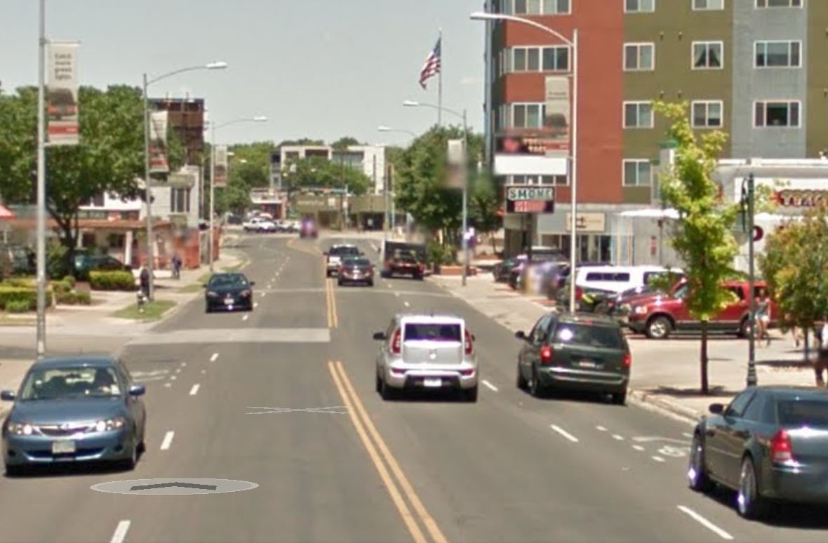
Guadalupe St., near W. 28th St. Graphic: Google Street View.

Guadalupe St., near W. 28th St. Graphic: Google Street View.

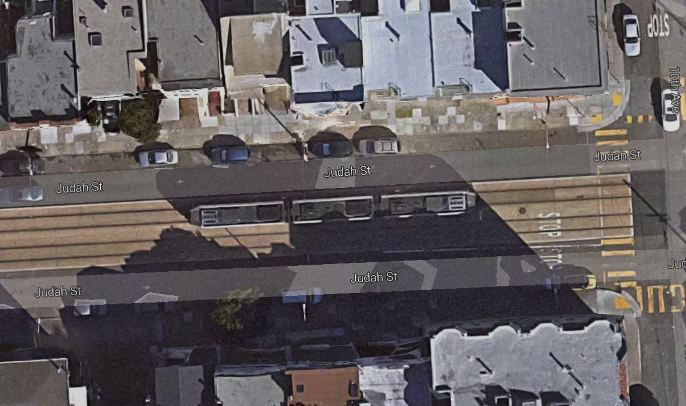
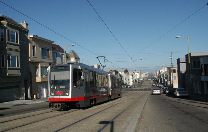
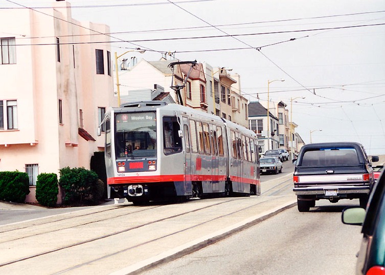
As Austin Rail Now has repeatedly pointed out, there are various ways that a starter light rail transit (LRT) line could be fitted workably into the Guadalupe-Lamar corridor. In our December 2014 article «San Francisco’s N-Judah Muni Metro line shows design option for light rail in Austin’s Guadalupe-Lamar corridor» we suggested a design alternative with the objective of inserting dedicated LRT lanes while minimizing disruption and cost and maintaining four traffic flow lanes. In this, we showed how a San Francisco LRT design could serve as a model for installing a dedicated LRT alignment in the relatively narrow 80-foot width of the Guadalupe-Lamar corridor (see illustrations below).


Muni Metro light rail

San Francisco’s N-Judah LRT line could serve as design model for Austin’s Guadalupe-Lamar corridor. Photo (copyright) Eric Haas.


Cross-sectional diagram

ARN’s proposed design shows how LRT, plus 4 traffic lanes and pedestrian/bicycle facilities, could be fitted into relatively narrow Guadalupe-Lamar corridor. Graphic: ARN. (Click to enlarge.)


This past December, another design proposal was made public by Austin community urban activist and Guadalupe-Lamar rail transit supporter Andrew Mayer. Compared to Austin Rail Now’s relatively minimalist approach, Andrew’s design is considerably more ambitious — with undoubtedly more urban impact and capital expense — but it embodies good ideas and hints at the kind of range of optional approaches available to ensure that LRT will work in this key central corridor.

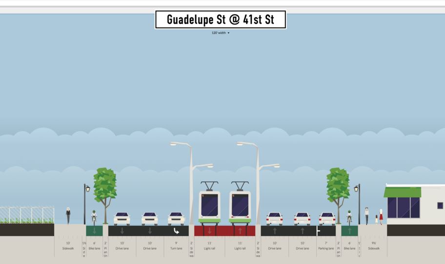
As Andrew explains, “For those who are interested in urban rail along Guadalupe and Lamar … I made a bunch of detailed cross-sections with streetmix several months ago.’ These are posted on the Imgur online image sharing community and image host site: http://imgur.com/a/gsa2n. In this post, we’ll illustrate Andrew’s proposal with sample graphics selected excerpted from his presentation. (Occasional stations are selected to illustrate typical proposed station design.)

Complete Streets approach

While almost any design proposing insertion of dedicated lanes for LRT into this corridor would represent to some extent a Complete Streets approach, Andrew’s proposal seems to be a particularly large-scale and aggressive implementation. As he elaborates,

I feel like these designs are relatively ambitious (2 transit lanes, 4 auto lanes, 2 separated bike lanes, 2 12 ft sidewalks along most of its length), but revamp Guadalupe and Lamar into more complete streets, while seeing if I could retain the existing number of auto lanes. Some of these ideas I came up with way back in 2009 (i.e. the split direction of traffic along west campus, the wide boulevard between 38th and 51st st), some are more recent.

Regardless how much you agree or disagree with these designs, I hope this contributes to the discussion of rail on Guadalupe/Lamar, as I feel like detailed discussion of street design is warranted if there is going to be a push to get [Guadalupe/Lamar/Congress] urban rail on the ballot as soon as possible.

Illustrating this approach is Andrew’s proposal for making the Drag more hospitable to LRT, pedestrian, and bicycle traffic by moving southbound traffic off of Guadalupe and onto either Nueces or “possibly” San Antonio St. (see map below). Andrew notes that “Relatively slow traffic (25 mph) due to traffic calming measures … makes street pedestrian friendly despite higher traffic volumes.”


Map snippet shows Guadalupe St. at right (east), with University of Texas campus bordering on east side; San Antonio and Nueces St. in West Campus neighborhood (west of Guadalupe). Graphic: Google Maps. (Click to enlarge.)

Map snippet shows Guadalupe St. at right (east), with University of Texas campus bordering on east side; San Antonio and Nueces St. in West Campus neighborhood (west of Guadalupe). Andrew Mayer’s design proposes moving southbound traffic from the Drag onto either Nueces or San Antonio. Graphic: Google Maps. (Click to enlarge.)


Proposed southbound traffic moved from Guadalupe to Nueces St. Graphic: Andrew Mayer. (Click to enlarge.)

Proposed southbound traffic moved from Guadalupe to Nueces St. Graphic: Andrew Mayer. (Click to enlarge.)


The Drag (West Campus)

As illustrated below, Andrew’s proposal for the main Drag segment (bordering the West Campus neighborhood) seems to envision dedicated LRT lanes occupying the west side of the street (former southbound lanes, with traffic now moved to either Nueces or San Antonio St.). Traffic lanes are narrowed to 10-ft width. Andrew comments: “Bike lane stays pretty much the same, but the parking lane and current southbound lanes are used for transit lanes. Northbound lanes are pushed slightly westward to allow for a separated bike lane and wider sidewalk.”
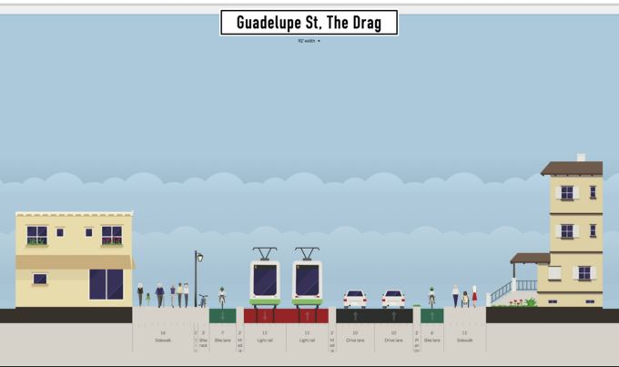

Proposed LRT alignment along Drag. Graphic: Andrew Mayer. (Click to enlarge.)

Proposed LRT alignment along Drag. Graphic: Andrew Mayer. (Click to enlarge.)


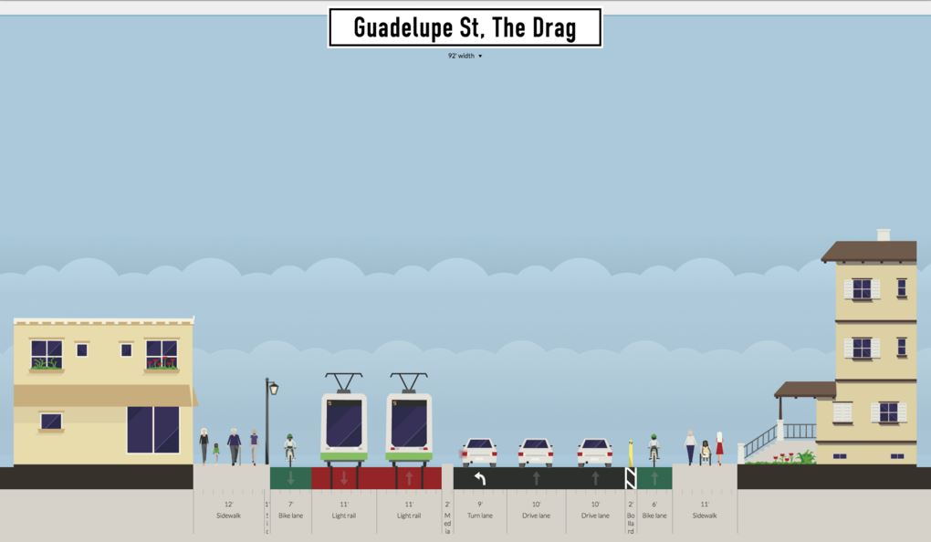
In this proposal, space for station platforms appears to be appropriated from pedestrian/bike space. It’s not explicit in Andrew’s design, but station platforms would likely be staggered across intersections (a common space-conserving technique in LRT design). Andrew also suggests that “platform” space might be allocated to use as a turning lane for motor vehicles (although this could conflict with the need for a station platform at that same point). Another option, deployed in Houston Metro’s MetroRail LRT design, is to allow a turn lane to share the LRT track (with traffic signal control coordinated with train movements — discussed briefly in our article «Houston’s MetroRail shows the way — How to fit urban rail into Austin’s Guadalupe and Lamar»).

Andrew comments that “In this design, there are two platforms and both open on the right side of the vehicle.” Andrew also suggests the possibility that “the idea was that some buses would also use the transit lanes (i.e. 803, 3, other bus lines that feed onto Guadalupe) and thus the right-hand platforms would be compatible with buses that only have doors on the right-hand side.” However, while sharing of lanes between buses and LRT is entirely possible and done in some situations, sharing where there is high-frequency service by both modes is not advisable. (Our own design proposed center-street running with allocation of at least a single curbside lane on each side for local bus access.)
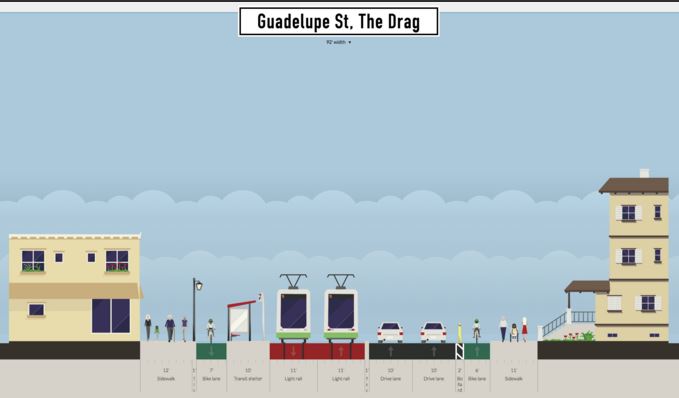

Proposed 24th St. station (southbound direction). Graphic: Andrew Mayer. (Click to enlarge.)
Proposed 24th St. station (southbound direction). Graphic: Andrew Mayer. (Click to enlarge.)


Proposed LRT alignment on Drag at 24th St., with possible turning lane. Graphic: Andrew Mayer.(Click to enlarge.)

Proposed LRT alignment on Drag at 24th St., with possible turning lane. Graphic: Andrew Mayer.(Click to enlarge.)


Between 24th and 29th St. (Andrew calls this the North Drag), Guadalupe narrows somewhat, constricting the space for LRT as well as pedestrian and bike facilities (see streetview at top of post, and aerial view, below). Andrew’s solution is to rely on the fact that southbound traffic has been re-routed to other streets; he also narrows the sidewalks and assumes that the bicycle route can be re-routed through this section to an available parallel street (Hemphill Park).
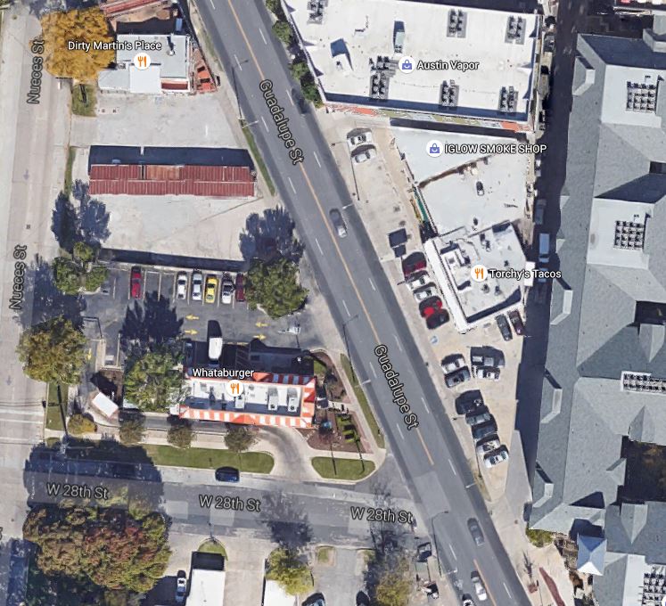

Aerial view of most constricted section of Guadalupe-Lamar corridor, between 24th-29th St. Graphic: Google Earth. (Click to enlarge.)
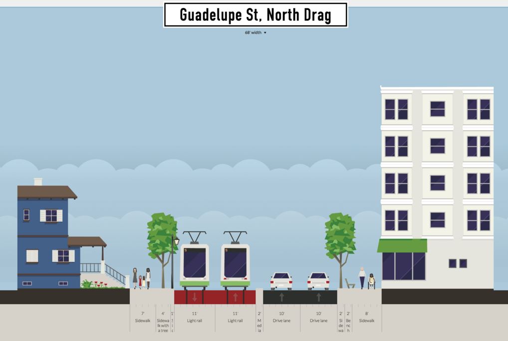
Aerial view of most constricted section of Guadalupe-Lamar corridor, between 24th-29th St. Graphic: Google Earth. (Click to enlarge.)


Proposed LRT alignment in narrow segment of Drag between 24th-29th St. Graphic: Andrew Mayer. (Click to enlarge.)

Proposed LRT alignment in narrow segment of Drag between 24th-29th St. Graphic: Andrew Mayer. (Click to enlarge.)


Central Guadalupe segment

To insert the LRT alignment in the relatively narrow segment of Guadalupe between 29th and 38th St., Andrew’s option seems to eliminate a traffic lane, although he assumes a turning lane in some cases. (With ROW assumed at 100 feet or more, Andrew’s plan would seem to require additional property acquisition in this section.)


Proposed LRT alignment in narrow segment of Guadalupe between 29th-38th St. Graphic: Andrew Mayer. (Click to enlarge.)
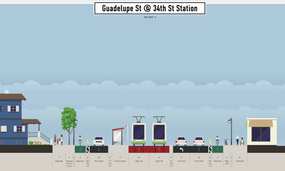
Proposed LRT alignment in narrow segment of Guadalupe between 29th-38th St. Graphic: Andrew Mayer. (Click to enlarge.)


Proposed 34th St. station (platform for southbound direction shown). Graphic: Andrew Mayer. (Click to enlarge.)

Proposed 34th St. station (platform for southbound direction shown). Graphic: Andrew Mayer. (Click to enlarge.)


At West 38th St. (shown in a Google Street View below), Andrew apparently proposes a short subway section, commenting “The transit lanes plunge beneath the street in a shallow cut-and-cover tunnel (basically an underpass) so there can be turning lanes for NB auto traffic without expanding the road’s ROW [right-of-way]….” Technically, this is possible — but quite an expensive feature, particularly since a station for this important east-west arterial would certainly be justified (and a subway station would add a considerable capital expense).
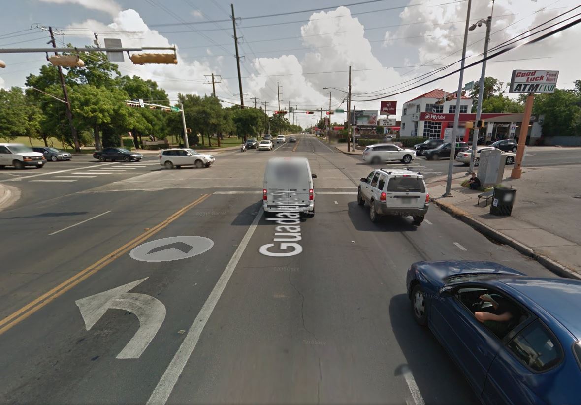

Street view of Guadalupe at 38th St. intersection. Graphic: Google Street View. (Click to enlarge.)

Street view of Guadalupe at 38th St. intersection. Graphic: Google Street View. (Click to enlarge.)


Our own design (which avoids any heavy civil works) assumes that LRT, like MetroRapid buses and ordinary traffic, would simply continue to operate through the W. 38th St. intersection at-grade, following the current surface street profile. Nevertheless, Andrew’s tunnel proposal indicates that there are indeed other options in the planning toolbox that could be considered to address engineering, political, or other concerns.

North of W. 38th St., for about eight blocks (to W. 45th St.) this section of Guadalupe is bordered on the east by leafy established neighborhoods such as Hancock and Hyde Park, and on the west by the publicly owned State of Texas property of the Department of Mental Health and Mental Retardation (MHMR, including the Austin State Hospital). Andrew proposes that a narrow strip of this public property be allocated for widening of the Guadalupe ROW, thus facilitating an LRT alignment: “Between 38th and 45th St, about 15 feet of feet from the [public property] is acquired to expand the ROW to 120 feet, allowing for an 2 bike lanes, 2 transit lanes, 4 auto lanes, and a parking lane or left turn lane, and 2 10 ft sidewalks.” Andrew suggests such a transfer of state land to the city would be plausible and workable “because the existing space is basically used for fields, some interior roads, and power lines, all of which can be moved/replaced relatively easily.”
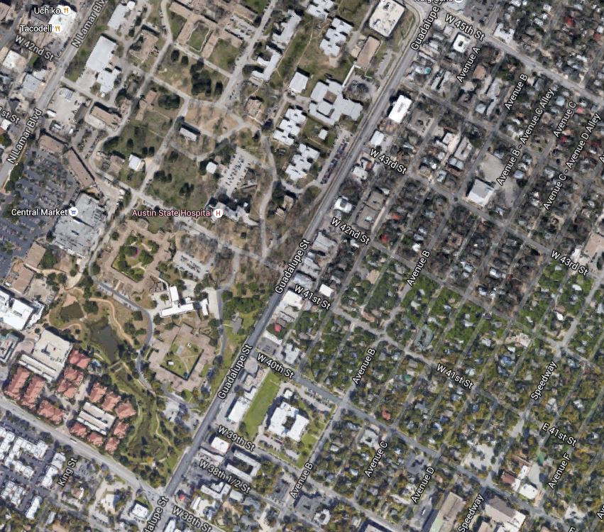

Aerial view of section of Guadalupe St. between 28th-45th St., showing MHMR bordering on west and established residential neighborhood on east side. Graphic: Google Earth. (Click to enlarge.)
Aerial view of section of Guadalupe St. between 28th-45th St., showing MHMR bordering on west and established residential neighborhood on east side. Graphic: Google Earth. (Click to enlarge.)


Proposed LRT alignment in segment of Guadalupe between 38th-45th St. Graphic: Andrew Mayer. (Click to enlarge.)

Proposed LRT alignment in segment of Guadalupe between 38th-45th St. Graphic: Andrew Mayer. (Click to enlarge.)


Use of this property in this manner as part of an LRT alignment has been proposed in various studies and propositions over the past 25 years. The day is surely coming when the State will seek to divest itself of this property, perhaps to private interests, so if an easement for ROW expansion is to be procured, official planning and action would seem urgent. Yet no public body, particularly neither Capital Metro nor the City of Austin, has taken a single official step toward this goal in all the years the idea has been on the table.

In the section north of W. 45th St. West Guadalupe St. branches off Guadalupe to connect with N. Lamar Blvd., forming the Triangle area (see map below). West Guadalupe provides a wider ROW here, and is followed by the LRT route, as shown in Andrew’s design, also below. Andrew comments that “Like in the 38th-45th portion, state land would be acquired (basically fields) to expand the roadway. In this case, the northbound auto and bike lanes would be just east of the existing oak trees next to Guadalupe.”
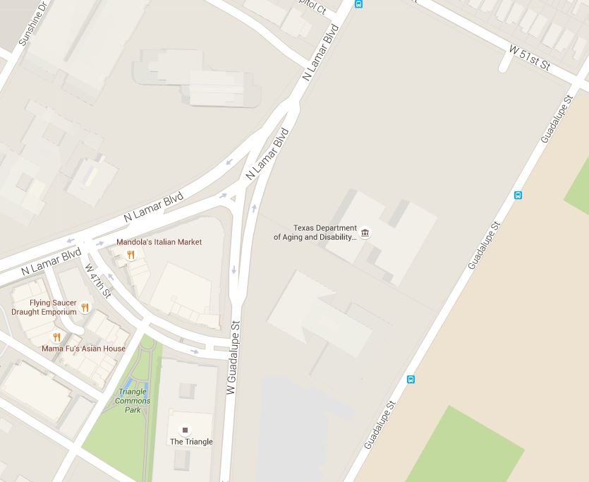

Map snippet shows West Guadalupe St. joining North Lamar at triangular land section now known as "the Triangle". Graphic: Google Maps. (Click to enlarge.)

Map snippet shows West Guadalupe St. joining North Lamar at triangular land section now known as “the Triangle”. Graphic: Google Maps. (Click to enlarge.)
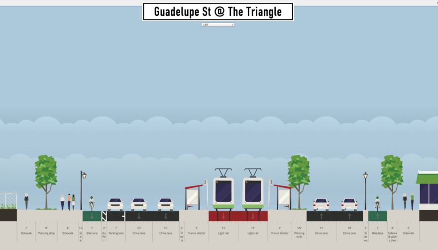

Proposed LRT alignment past Triangle, with station. Graphic: Andrew Mayer. (Click to enlarge.)

Proposed LRT alignment past Triangle, with station. Graphic: Andrew Mayer. (Click to enlarge.)


North Lamar segment

Having transitioned to North Lamar, the alignment with Andrew’s proposed design would seem to require acquisition of more ROW to accommodate a cross-section width of 115 feet for pedestrian and bike facilities, landscaping, and buffer zones (see typical cross-section, below).

As Andrew subsequently explains,

The expanded roadway would work by turning the parking spaces in front of businesses into larger sidewalks and bike lanes. Parking lanes would be put in between the auto lanes and bike lanes where possible to allow for some parking capacity. I HIGHLY recommend doing a study of the traffic going to businesses along this section of N Lamar. How many customers can access the business by foot/bike/transit? For those who have to drive, is there enough parking on the street or behind the business?

Andrew notes that “Interestingly, this section of Lamar Blvd is one of the study areas for CodeNEXT [current process revising Austin’s land-use regulations], so perhaps there is data available there.”

Andrew’s wide streetscape design (which undoubtedly would require extensive and costly adjacent property acquisition) contrasts with our own narrower design proposal which assumed insertion of LRT within existing public ROW (except at intersections with stations, where modest widening would occur). There’s no question that widening North Lamar with amenities such as Andrew has suggested would create a significantly enhanced environment for the public. The issue here is whether it should be included in the initial starter line design, or proposed as a later major upgrade to the corridor.
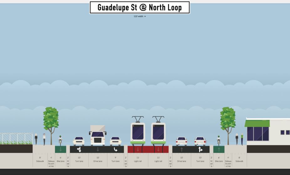

Proposed typical LRT alignment in North Lamar. Graphic: Andrew Mayer. (Click to enlarge.)

Proposed typical LRT alignment in North Lamar. Graphic: Andrew Mayer. (Click to enlarge.)


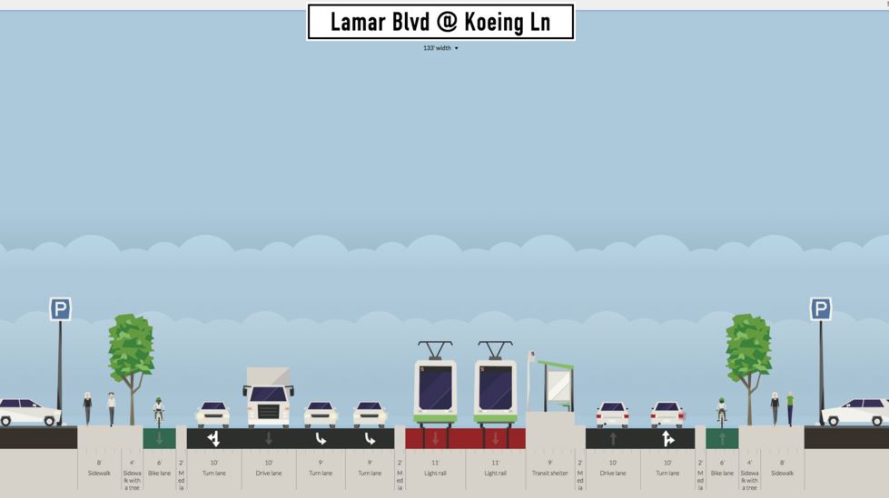
For a station at the intersection of North Lamar with the major east-west arterial Koenig Lane (shown below), Andrew remarks that “Large parking lots in the shopping center, unused TxDOT land (that was going to be used for freeway along [Koenig] Ln), and fields along the DPS building could all be acquired to make a full-sized boulevard next to [Koenig] Ln.”

Proposed Koenig Lane station (platform for northbound direction shown). Graphic: Andrew Mayer. (Click to enlarge.)

Proposed Koenig Lane station (platform for northbound direction shown). Graphic: Andrew Mayer. (Click to enlarge.)


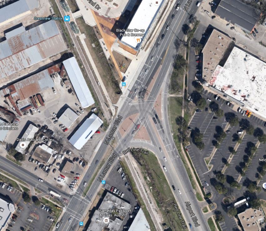
Andrew’s designs terminate at Crestview — a major and rather complex nexus, with the heavily used Airport Blvd. intersecting and the MetroRail Red Line rail transit route crossing North Lamar, parallel to Airport (see aerial view, below). Maintaining a 115-ft ROW assumption, Andrew provides a surface LRT design, shown further below; although an interchange station would be essential here, none is presented. Calling his surface design “Alternative 1”, Andrew explains that “Transit lanes stay at grade, there are only 2 instead of 3 NB auto lanes, and the sidewalks are only 12 ft wide each.”

Aerial view of complex intersection of North Lamar with Airport Blvd. and Red Line alignment. Graphic: Google Earth. (Click to enlarge.)

Aerial view of complex intersection of North Lamar with Airport Blvd. and Red Line alignment. Graphic: Google Earth. (Click to enlarge.)


Proposed typical LRT alignment at Crestview. Graphic: Andrew Mayer. (Click to enlarge.)

Proposed typical LRT alignment at Crestview. Graphic: Andrew Mayer. (Click to enlarge.)


Andrew also proposes an “Alternative 2” in which “Transit lanes and the station go into a cut-and-cover tunnel beneath the auto lanes.” He acknowledges that such a subway would be “More expensive and complex to construct, but retains the same number of NB auto lanes and allows for wider sidewalks and more parking.” Andrew indicates a preference for his first alternative, keeping LRT on the surface.

Austin Rail Now believes that an initial surface starter LRT line could safely and efficiently operate through the Crestview intersection as it basically exists. Ultimately, however, some method of grade separation at this complicated intersection may be prudent. We believe this should involve either tunneling or elevating (or both) the motor vehicle trafficleaving the surface to transit, pedestrians, and bicycles. Not only is this approach more compatible with a livable, walkable environment, but it also recognizes that there is many times greater funding available, from all sources, for roadways, while transit is strapped for resources.

Summing up

Considering both our own design proposal and Andrew Mayer’s more ambitious approach, our thoughts return to the controversy over Project Connect’s ill-fated urban rail planning process and proposal that emerged through the fall of 2013 and eventually crashed and burned in the November 2014 vote — in particular, the expressions of skepticism, utter hopelessness, deficit of vision, and outright hostile resistance voiced by several members of the Central Corridor Advisory Group (CCAG) and Austin City Council in their efforts to disparage and dismiss the possibility of installing LRT in the Guadalupe-Lamar corridor. Fortunately, that nonsense (whether based on misunderstanding, ignorance, or cynical political sniping) has mostly evaporated.

Between the two designs now already on the table, it’s possible to see that in reality a broad range of alternatives and design options is available to make this happen. It’s neither impossible nor astronomically expensive. We believe our “minimalist” design is the most immediately affordable, workable, and attractive to voters and the public at large — but that’s just our assessment; we strongly believe all options are worth considering.

It’s time to end Austin’s long saga of indecision, conflict, bumbling, bungling, and diddling. Guadalupe-Lamar is truly the city’s strongest “central corridor”, by far the most logical backbone for a light rail transit starter line. The major task at hand is mustering the community and political will to bring an LRT project here to fruition. ■

h1

Minneapolis light rail — possible model for Austin

30 December 2015

Two light rail trains pass on 5th St., a major downtown east-west thoroughfare with dedicated lanes for light rail. Photo: L. Henry.

In downtown Minneapolis, two light rail trains pass on 5th St., a major east-west thoroughfare with dedicated lanes for light rail. Photo: L. Henry.

Last month, the 13th National Light Rail Conference, co-sponsored by the American Public Transportation Association (APTA) and U.S. Transportation Research Board (TRB), was held in Minneapolis, whose initial light rail transit (LRT) starter line has been operating since 2004 (see «Minneapolis-St. Paul (Twin Cities) Public Transport»). Attending the conference were two contributors to Austin Rail Now, Dave Dobbs and Lyndon Henry.

Minneapolis’s LRT system has been a spectacular success — particularly by exceeding ridership projections and providing more efficient and cost-effective transit service through lowering the average operating and maintenance (O&M) cost of urban transit per passenger-mile. Add to that the significant improvement of urban mobility and livability. This has convinced local policymakers and planners that further investment and expansion of the system are justified, leading to the opening of a second route, crossing the Mississippi River and connecting the Twin Cities of Minneapolis and St. Paul, Minnesota, in 2014. Additional routes are now in development, and the Northstar Line, a regional passenger rail (commuter) line serving northwest suburbs and exurban communities, was also launched in 2009. See: «Minneapolis Area: Northstar Regional Rail Links Northwest Communities With Central City».

Overall, the Minneapolis LRT system appears to be a highly appropriate model for other cities — and especially Austin, where community support has been growing for an LRT starter line project in the Guadalupe-Lamar corridor (Guadalupe St.-North Lamar Blvd.). (See «Plan for galvanizing Austin’s public transport development: Light rail starter line in Guadalupe-Lamar».) As with Minneapolis’s original starter line, Austin’s Guadalupe-Lamar LRT line could serve as the trunk or spine for additional lines branching out into other segments of the urban area.

This article/photo-essay presents a brief summary description of the Minneapolis LRT system and focuses especially on particular features that highlight why LRT is such an exceptionally appropriate and desirable public transport mode for a city like Austin.

Overview

So far, the Twin Cities LRT system extends approximately 23 miles, mainly south and east of central Minneapolis, as illustrated in the map below.


Map of Minneapolis Metro Transit rail transit system shows Blue and Green LRT Lines plus Northstar regional rail line (grey) to the northwest. Map adapted by ARN from Metro Transit map. (Click to enlarge.)

Map of Minneapolis Metro Transit rail transit system shows Blue and Green LRT Lines plus Northstar regional rail line (grey) to the northwest. Map adapted by ARN from Metro Transit map. (Click to enlarge.)


Blue Line — Originally dubbed the Hiawatha Line because much of its alignment uses a former railroad right-of-way (ROW) paralleling the city’s Hiawatha Avenue, the initial route (opened 2004) is now designated the Blue Line. Extended slightly, it now stretches about 12 miles south from the city’s downtown to the airport and terminates at the Mall of America. In the CBD, generally from the Downtown East station west, the Blue Line runs in dedicated lanes within 5th Street — in effect, a quasi-transit-mall configuration with some access allocated to motor vehicles (see photo at top of post).

Outside the city's core area, much of the Blue Line alignment, running on former freight railroad right-of-way, parallels Hiawatha Avenue, seen on the far left in this view. Photo: L. Henry.

Outside the city’s core area, much of the Blue Line alignment, running on former freight railroad right-of-way, parallels Hiawatha Avenue, seen on the far left in this view. Photo: L. Henry. (Click to enlarge.)


Blue Line train at Cedar-Riverside station, closer in to the CBD, where the former railroad ROW is quite narrow. This is similar to the narrow railroad ROW of Austin's MetroRail (Red Line), which ARN and other groups have advocated to be converted to LRT (from its current status as a diesel-propulsion light railway). LRT's electric propulsion enables faster, smoother train operation that is less costly, cleaner, and friendlier to urban livability.

Blue Line train at Cedar-Riverside station, closer in to the CBD, where the former railroad ROW is quite narrow. This is similar to the narrow railroad ROW of Austin’s MetroRail (Red Line), which ARN and other groups have advocated to be converted to LRT (from its current status as a diesel-propulsion light railway). LRT’s electric propulsion enables faster, smoother train operation that is cheaper, cleaner, and friendlier to urban livability. (Photo: L. Henry.)


Green Line — Also called the Central Line, this 11-mile route (opened 2014) crosses the Mississippi River to link the downtowns of Minneapolis and St. Paul. It also re-establishes what was once the Twin Cities’ formerly busiest streetcar route, part of the region’s vast, efficient electric rail system destroyed in the 1950s amidst the widespread national Transit Devastation, when public policy eliminated urban and interurban electric railways in a disastrous effort to encourage (and coerce) the American population to rely exclusively on personal automobiles and other rubber-tired transport (buses) rather than urban and interurban electric rail for mobility.

In contrast to the Blue Line, the Green Line is routed almost entirely via dedicated lanes or reservations within major arterials and other thoroughfares, with a particularly long stretch along University Avenue west of the Mississippi and toward St. Paul. In the Minneapolis CBD, the Green Line shares dedicated tracks on 5th St. with the Blue Line. Also of note is the use of the iconic Washington Avenue bridge (retrofitted to accommodate LRT) to cross the Mississippi River, as discussed further below.


Green Line alignment in median of University Avenue. Photo: L. Henry.

Green Line alignment in median of University Avenue. Photo: L. Henry.


Joint use of 5th St. trunk line — As mentioned above, both the Blue and Green Lines share tracks of the original 5th St. trunk route in downtown Minneapolis. A section of this alignment is illustrated in the photo at the top of this post. The following photo shows one of the stations in this alignment.


Passengers awaiting arrival of Green Line train at downtown Warehouse District/Hennepin Avenue station in 5th St. alignment. Photo: L. Henry.

Passengers awaiting arrival of Green Line train at downtown Warehouse District/Hennepin Avenue station in 5th St. alignment. Photo: L. Henry.


Self-service fare system — As with most new LRT systems, the Minneapolis operation uses self-service fare collection. Passengers purchase tickets at ticket vending machines (TVMs). Roving inspectors then spot-check passengers’ tickets aboard trains. (Austin’s MetroRail also uses the self-service system.)


Passenger purchases ticket from TVM at downtown station. Photo: L. Henry.

Passenger purchases ticket from TVM at downtown station. Photo: L. Henry.


Rail access/interconnections among major activity centers — The Twin Cities LRT system is outstanding in accessing and interconnecting some of the urban area’s most significant activity centers. These include, for example:

• Downtown Minneapolis
• Downtown St. Paul
• Minneapolis-St. Paul International Airport
• Twin Cities Amtrak station (Union Depot, St. Paul)
• University of Minnesota (St. Paul)
• Minnesota state capitol (St. Paul)
• VA Medical Center
• Major shopping malls (Mall of America and University Ave. West/Hamline Ave.)
• Target Field sports center

Airport access

LRT can provide a cost-effective way to implement rail access to a city’s major local airport. However, typically the heaviest airport ridership tends to come from employees rather than passengers, so to be cost-effective the LRT route must also serve other significant sources of ridership close by (exemplified by LRT routes to airports in Baltimore, St. Louis, Portland, Phoenix, Seattle, Dallas, and Salt Lake City).

Minneapolis’s Blue Line LRT strongly fulfills this requirement, since its airport stations are situated in the middle of good traffic generators on both sides (between the CBD on the north end and the Mall of America on the south end, with other activity centers and residential areas also in between). From visual observation, it’s clear that lots of passengers and airline crews utilize the convenience of the LRT connection.


Blue Line train arriving at Airport Humphrey Terminal station. Photo: L. Henry.

Blue Line train arriving at Airport Humphrey Terminal station. Photo: L. Henry.


Lots of visible baggage on Blue Line train gives an indication that LRT service to Minneapolis's airport is well-used by air passengers. Photo: L. Henry.

Lots of visible baggage on Blue Line train gives an indication that LRT service to Minneapolis’s airport is well-used by air passengers. Photo: L. Henry.


Traveler with baggage boards Blue Line train at downtown station. With level boarding (station platform level with car floor), carrying on luggage is easy. Photo: L. Henry.

Traveler with baggage boards Blue Line train at downtown station. With level boarding (station platform level with car floor), carrying on luggage is easy. Photo: L. Henry.


Shopping mall access

Access to shopping malls is a major advantage for any rail transit line, and a huge convenience for the public (especially out-of-town visitors). The Minneapolis LRT system provides access to malls in both Bloomington (south of Minneapolis) and St. Paul.


Blue Line train leaves the Mall of America station located in the parking garage of this mall, which hosts the most mall visitors  in the world and is a popular tourist destination. Photo: Ymtram.mashke.org.

Blue Line train leaves the Mall of America station located in the parking garage of this giant mall, which hosts the most mall visitors in the world and is a popular tourist destination. Photo: Ymtram.mashke.org.


Green Line's Hamline station accesses major mall on University Ave. at West/Hamline Ave., with two "big box" stores (Walmart and Target). Photo: L. Henry.

Green Line’s Hamline station accesses major mall on University Ave. at West/Hamline Ave., with two “big box” stores (Walmart and Target). Photo: L. Henry.


Bridge retrofitted for LRT

To cross the Mississippi River, the Green Line uses the iconic Washington Avenue bridge, rather than a specially built bridge. According to the Minneapolis Metro Council, retrofitting the bridge rendered “cost savings to the project estimated at $80 million to $100 million and a minimum of two years in project schedule in comparison to a full bridge replacement.” The bridge was retrofitted “for an estimated $21 million, $2 million under budget….”

In Austin, ARN and other groups have advocated retrofitting either the Congress Avenue or South First (Drake) bridge to cross Lady Bird Lake (Colorado River) and link South Austin to the rest of the city on the north side of the river. We suggest this would be far more financially accessible and cost-effective than the expense of a totally new, specially constructed bridge.


Green Line train crosses over Mississippi River on newly retrofitted Washington Ave. bridge. Photo: Streets.mn.

Green Line train crosses over Mississippi River on newly retrofitted Washington Ave. bridge. Photo: Streets.mn.


Solution to complicated intersections

Somewhat like Austin’s MetroRail alignment along Airport Blvd., the Minneapolis Blue Line along Hiawatha Avenue encounters design challenges at intersections, especially where these approach at an angle. How these problems have been dealt with may suggest some traffic solutions in Austin with respect to a potential intersection of road traffic with a proposed Guadalupe-Lamar LRT at Airport/North Lamar.


In this Google Earth view, Hiawatha Ave., with the LRT line paralleling it on its western edge, runs diagonally north-south through the center of the photo. The 38th St. LRT station can also be seen, while E. 38th St. crosses both LRT line and Hiawatha Ave. east-west, in the bottom third of the graphic. Note that Hiawatha and the LRT line intersect E. 38th St. at about a 60-degree angle, somewhat similarly to Airport Blvd and N. Lamar and the MetroRail Red Line in Austin. Photo: ARN, from Google Earth.

In this Google Earth view, Hiawatha Ave., with the LRT line paralleling it on its western edge, runs diagonally north-south through the center of the photo. The 38th St. LRT station can also be seen, while E. 38th St. crosses both LRT line and Hiawatha Ave. east-west, in the bottom third of the graphic. Note that Hiawatha and the LRT line intersect E. 38th St. at about a 60-degree angle, somewhat similarly to Airport Blvd and N. Lamar and the MetroRail Red Line in Austin. Photo: ARN, from Google Earth.


From a surface view, this shows the intersection protected with crossing gates. Photo: ARN, from Google Street View.

From a surface view, this shows the intersection protected with crossing gates. Photo: ARN, from Google Street View.


Easy transport of bicycles

With typically spacious vehicles, LRT has the advantage of accommodating onboard bicycles, in contrast with the constrained interior space of buses, which usually require cyclists to place their bikes on an outside rack (if one is available). These views show how bikes are accommodated aboard Twin Cities LRT trains.


Bikes can be hung on special racks inside the LRT cars. Photo: L. Henry.

Bikes can be hung on special racks inside the LRT cars. Photo: L. Henry.


In some cases, smaller bikes are simply held by the passenger. Photo: L. Henry.

In some cases, smaller bikes are simply held by the passenger. Photo: L. Henry.


Easy accessibility for mobility-challenged

Level boarding, spacious interiors, and smooth ride qualities mean that LRT cars are exceptional in their ability to accommodate disabled, wheelchair-using, and other mobility challenged passengers. This also means that long delays in boarding wheelchairs, typical of buses, are eliminated, thus speeding transit service for all.


Passenger in wheelchair boards train at downtown station. Photo: L. Henry.

Passenger in wheelchair boards train at downtown station. Photo: L. Henry.


Passenger in wheelchair easily maneuvers chair into accessible space aboard car. In contrast to buses — no tiedowns, no operator assistance needed, no passengers ousted from their seats!  Photo: L. Henry.

Passenger in wheelchair easily maneuvers chair into accessible space aboard car. In contrast to buses — no tiedowns, no operator assistance needed, no passengers ousted from their seats! Photo: L. Henry.


Summing up

Certainly, a reasonable case can be made for considering Minneapolis (along with Portland, Salt Lake City, Phoenix, and several other cities) as a particularly appropriate model for designing an LRT system for Austin, starting in the Guadalupe-Lamar corridor. As this discussion/photo-essay has attempted to suggest, smart, cost-effective design can be combined with significant public transit conveniences and advantages to galvanize public support, attract significant ridership. improve mobility and urban livability, and reduce the cost burden of urban travel. ■


Blue Line train approaches station along Hiawatha Avenue alignment. Photo: L. Henry.

Blue Line train approaches station along Hiawatha Avenue alignment. Photo: L. Henry.

h1

Texas Tribune op-ed urges support for “Plan B” light rail in Guadalupe-Lamar

27 July 2015

TribTalk op-ed headline with photo of Houston light rail train. (Screenshot: ARN)

TribTalk op-ed headline with photo of Houston light rail train. (Screenshot: ARN)

The case for light rail transit (LRT) in Austin’s Guadalupe-Lamar corridor just received a huge boost with the publication of an op-ed in TribTalk, the op-ed web page of the widely respected Texas Tribune.

“It may seem unlikely in Texas, but across the state, people are benefiting from rail transit” say William S. Lind and Glen D. Bottoms in their commentary (ARN emphasis added here and subsequently).

In Dallas, which now has the country’s largest light rail system, more than 100,000 Texans escape traffic congestion each day by riding Dallas Area Rapid Transit rail. In Houston, the light rail Red Line draws about 3,500 weekday boardings per mile, more than any other modern light rail operation in the country.

“Critics, many of whom call themselves conservatives (though most are really libertarians), predicted that both systems would fail because no one would ride them” they add.

Both writers are venerable, renowned veterans of the U.S. public transportation industry. Lind was also a close associate of the late conservative leader Paul Weyrich, a well-known advocate of rail transit among conservative circles.

In their op-ed, Lind and Bottoms note that “As conservatives, we find it odd that many people expect us to oppose public transportation, especially rail.”

In fact, high-quality transit, which usually means rail, benefits conservatives in a number of important ways. It spurs development, something conservatives generally favor, especially in Texas. It saves people, including conservatives, precious time, because those who ride rail transit can work or read on the train instead of wasting hours stuck in traffic. Transit of all kinds helps poor people get to jobs, which conservatives prefer over paying welfare. And rail transit, especially streetcars, helps support retail in downtowns by increasing the number of middle-class people on sidewalks.

Libertarians’ arguments against rail transit mostly boil down to one criticism: It’s subsidized. Yes, it is. So is all other transportation. Highway user fees now cover only 47.5 percent of the cost of highways. Nationally, rail transit of all types covers 50 percent of its operating costs from fares. It’s a veritable wash. In contrast, bus systems, which libertarians often favor over rail, cover only 28 percent of their operating costs from the farebox.

“Regrettably,” the writers caution, “conservatives’ tendency to accept libertarians’ arguments against rail transit (without checking their numbers) may deprive Texas conservatives of more chances to escape traffic congestion.”

As a case in point, they turn to Austin, explaining that it “may be different from other Texas cities in many ways, but not when it comes to traffic.”

The city’s rapidly growing population has packed its freeways at rush hours. And as other cities have found, building more freeways is not the answer. New lanes fill up as soon as they’re opened, and limited-access freeways in urban areas slice up and kill surrounding communities.

While they recount that “Austin voters last year rejected a poorly conceived light rail proposal that supporters said would help alleviate that congestion”, Lind and Bottoms argues that the failure of that plan nevertheless

…could be a good thing because it opened the door to a “Plan B” rail line that would serve the city better. A basic rule of rail transit planning is to “build it where people want to go,” and the alternative plan proposes a rail line that would run along Guadalupe Street and North Lamar Boulevard, Austin’s most heavily traveled urban corridor. We hope Austin conservatives will support “Plan B.”

Included in their commentary is a hyperlink to our own article from last October, «A “Plan B” proposal for a Guadalupe-Lamar alternative urban rail starter line». (Also see our recent article «Plan for galvanizing Austin’s public transport development: Light rail starter line in Guadalupe-Lamar», which links to our series of articles for this alternative plan with “what, where, how, and how soon” details about the proposed project.

Lind and Bottoms also point to other opportunities for rail, such as the streetcar project in El Paso and the Texas Central Railway highspeed rail system proposed to connect Dallas and Houston. “A combination of high-speed rail connecting Texas cities and good light rail and streetcar systems in those cities would make Texas a national leader…” they say in their conclusion. ■

h1

Strong community support for Guadalupe-Lamar light rail continues — but officials seem oblivious

3 January 2015

Graphic: Midwest District Blog.

Graphic: Midwest District Blog.

While Project Connect’s disastrously flawed Highland-Riverside “urban rail” plan recedes into history — decisively rejected by voters on Nov. 4th — community support for a sensible, workable, affordable light rail transit (LRT) plan continues. For example, see:

A “Plan B” proposal for a Guadalupe-Lamar alternative urban rail starter line

Resume planning light rail in Guadalupe-Lamar!

As this website reported in a “post-mortem” analysis posted a day after the Nov. 4th rail vote, “…it’s clear that Austin is basically a very pro-rail city. Widespread community sentiment for urban rail — much of it for just about any rail line, anywhere — was palpably strong.”

The Highland-Riverside plan may be dead, but the campaign for a Guadalupe-Lamar light rail starter line is firing up. Light rail in this heavily traveled, high-density central corridor can become the basic spine of a far more effective and truly extensive urban rail system in the future for the city.

There’s already a strong constituency and base of support for light rail transit (LRT) in the Guadalupe-Lamar corridor.

Ironically, part of the evidence of community support for rail comes from the Nov. 4th election results themselves. While a majority voted to defeat the Highland-Riverside plan on the ballot, a tally of precincts suggests strong pro-rail sentiment in the heart of the city. This is shown in an interactive election results map provided by Travis County, illustrating precinct-by-precinct vote preponderance, with pro-rail sentiment indicated as light blue (or turquoise) and opposition to the measure as lavender or purple (screenshot below).


Screenshot of interactive map of Nov. 4th "urban rail" vote by precinct. Source: Travis County. (Click to enlarge.)

Screenshot of interactive map of Nov. 4th “urban rail” vote by precinct. Source: Travis County. (Click to enlarge.)


Although the central pro-rail precincts (blue in the above map) seem surrounded by a sea of precincts against the measure, it’s important to realize that those central precincts include some of the densest and most populous in the city. An analysis by veteran Guadalupe-Lamar LRT supporter Mike Dahmus suggests that these central-city precincts that voted for the rail measure did so less enthusiastically than in the 2000 LRT referendum — tending to corroborate the hypothesis that opposition from rail transit advocates and supporters played a major role in helping defeat the official Highland-Riverside plan, perceived as flawed and even “worse than nothing”. (Stronger core-city support could have outweighed opposition in suburban precincts.)

Conversely, this tends to bolster the plausibility that a sensible, widely supported light rail (“urban rail”) proposal could muster the majority of votes needed to pass. The prospect of an LRT starter line project in the crucial, central, high-travel Guadalupe-Lamar corridor has already mustered affirmations of support from adjacent neighborhood associations, the UT student government, and other community sources, and would seem to have strong potential to succeed as a ballot measure.

Kate Harrington, in an article posted by the Building ATX.com website on Nov. 11th, just a week after the Nov. 4th vote, reminded readers of Austin Mayor Lee Leffingwell’s prediction that if the “urban rail” bond measure failed it “would mean that no new transit initiative would take shape for a decade or more.” But, Harrington observed, “Instead, it seems the issue is anything but dead. … Since voters decisively shot down the rail proposal last week, conversations about a possible ‘Plan B’ have sprung up all over the city.”

Most recently, via an interactive, annotated map (see screenshot below), the latest proposal for a Guadalupe-Lamar LRT route has been publicized by Brad Parsons, a community activist involved with urban and transportation issues. Starting at the North Lamar Transit Center at U.S. 183, this route would follow North Lamar Blvd., Guadalupe St., Nueces St., San Antonio St., and finally Guadalupe and Lavaca St. past established central Austin neighborhoods and activity centers, through the West Campus, past the Capitol Complex, and into Austin’s CBD. Brad’s proposal underscores the fact that there’s a variety of ways that LRT can be fitted into this constrained but high-volume traffic corridor.


Map of Guadalupe-Lamar corridor light rail route proposed by Brad Parsons.

Map of Guadalupe-Lamar corridor light rail route proposed by Brad Parsons. (Click to enlarge.)


Throughout last year’s ballot measure campaign, supporters of the official rail proposal (led by Let’s Go Austin) continuously depicted “urban rail” as absolutely essential to secure and sustain Austin’s future mobility and livability. With the slogan “Rail or Fail”, Mayor Leffingwell himself repeatedly warned that Austin needed an urban rail transit system to maintain its economic vitality and mobility in the face of steadily menacing traffic “gridlock”. Furthermore, news reports and competent analyses emphasized that simply building more highways or adding more buses to the roadway grid was counterproductive.

But while much of the Austin public seem to perceive and even embrace the alternative of an urban rail “Plan B” starter line routed in Guadalupe-Lamar (where the population density, major employment and activity centers, and heavy local travel are), key public officials and former leaders of the Let’s Go Austin pro-rail campaign seem to have been struck blind and deaf, oblivious to the obvious feasibility of LRT in the city’s most central and heavily used local corridor. For instance, the City’s Guadalupe Street Corridor Study, suddenly awakened from apparent dormancy to hold its first widely publicized public event on Dec. 3rd discussing “how to improve” the Drag, has explicitly ruled out consideration of rail transit, according to project manager Alan Hughes.

For Capital Metro board chairman (and outgoing City Councilmember) Mike Martinez, who had been expounding for the past year that “urban rail” was absolutely essential, further study of an alternative LRT plan now is apparently inconceivable. Martinez’s new mantra — basically a variant of “my way or the highway” — is that “the voters have spoken”, rail is off the table, and “we have to become the best bus city in America.”

Evidently at Martinez’s behest, Capital Metro has been sifting about for other ways to spend nearly $3 million in planning funds previously scheduled for further “urban rail” study (on the now-defunct Highland-Riverside proposal). Re-allocate these funds to a resumption of planning for LRT in Guadalupe-Lamar (where urban rail would actually make overwhelmingly good sense)? Certainly not.


Capital Metro's "Heart of the City" latest projects propose to usurp millions in urban rail planning funds for other purposes. Screenshot from video of Dec. 15th Capital Metro board meeting.

Capital Metro’s “Heart of the City” latest projects propose to usurp millions in urban rail planning funds for other purposes. Screenshot from video of Dec. 15th Capital Metro board meeting.


Instead, at a Dec. 15th Capital Metro board meeting, Todd Hemingson, the agency’s head of strategic planning and development, outlined a “Heart of the City” list of potential study efforts (see photo of PowerPoint slide, above). Hemingson’s presentation made clear that even the two items seemingly most relevant to the central Guadalupe-Lamar corridor — “Guadalupe/Lavaca Transit Mall” and “Central Corridor Transit Entryways” — were actually focused merely on modest bus service expansion and infrastructure (including a possible tunnel for buses between the Loop 1 toll lanes and arterials leading into downtown).

Austin — supposedly the most “progressive” city in the “reddest” rightwing state of Texas — has a distinctive (read: notorious) reputation for dithering, dallying, and derailing in its public transport planning … while excluding the general public and making key decisions secretively behind closed doors. Surely the time has come to break this pattern. Will a new mayor and a new district-based 10-1 City Council provide an opportunity to scrap this modus operandi of failure and disaster, bring the community into authentic involvement in crucial decisions, and move forward with the first phase of LRT as a starter line in Guadalupe-Lamar?

We’re trying our hardest to help make that happen. ■


Light rail in Guadalupe and North Lamar could be modeled after San Francisco's N-Line route in Judah St., seen in this satellite view from Google Maps. Screenshot: Dave Dobbs.

Light rail in Guadalupe and North Lamar could be modeled after San Francisco’s N-Line route in Judah St., seen in this satellite view from Google Maps. Screenshot: Dave Dobbs. (Click to enlarge.)

h1

Resume planning light rail in Guadalupe-Lamar!

11 December 2014

Guadalupe St. at W. 24th St., looking south. The Drag, passing one of the densest residential neighborhoods in Texas and busy commercial district, is major segment of high- travel-density Guadalupe-Lamar corridor. Photo: Google Maps Streetview.

Guadalupe St. at W. 24th St., looking south. The Drag, passing one of the densest residential neighborhoods in Texas and busy commercial district, is major segment of high-
travel-density Guadalupe-Lamar corridor. Photo: Google Maps Streetview.

By Lyndon Henry

The following comments, adapted here to webpage format, were distributed to a public event sponsored by the City of Austin’s Guadalupe Transportation Corridor Project on 3 December 2014. Lyndon Henry is a transportation planning consultant, a technical consultant to the Light Rail Now Project, and a contributing editor to this website.

► Guadalupe-Lamar light rail transit starter line makes most sense

• A light rail transit (LRT) starter line for the Guadalupe-Lamar (G-L) corridor has been studied for 40 years, with at least $30 million invested. (Source: AustinRailNow.com) This is a plan that makes sense, and it’s time to move forward with it!

• G-L is Austin’s most central north-south corridor, with by far the heaviest travel and congestion. A starter line from the North Lamar Transit Center to downtown, serving this busy corridor, established neighborhoods, the high-density West Campus, the Capitol Complex, and the central business district, with a branch to the Seaholm-Amtrak development area, is estimated to carry 30,000-40,000 rider-trips a day. (Source: AustinRailNow.com)

Proposed 6.8-mile "Plan B" light rail transit line in Guadalupe-Lamar corridor would have 17 stations and connect  the North Lamar Transit Center at U.S> 183 with Crestview, the Triangle, UT and the West Campus, the Capitol Complex, the CBD, and the Seaholm-Amtrak area. It's projected to serve 3 times the ridership of the Prop. 1 Highland-Riverside rail line at slightly over half the capital cost.

6.8-mile starter line, proposed by Austin Rail Now, could launch electric LRT service in the Guadalupe-Lamar corridor for less than $600 million. Proposal includes dedicated lanes for rail, 4 traffic lanes, and sidewalks. Map: ARN. (Click to enlarge.)

• A surface starter line like the one shown at left (6.8 miles) could be installed for less than $600 million. With affordable, cost-effective design, this would become the central spine of an eventual citywide system branching north, south, east, and west throughout our region.

• The Guadalupe Transportation Corridor Project should be reconfigured to focus on development of this long-deferred LRT project, along with the $2.5 million of previous funding for the now-defunct Highland-Riverside urban rail plan, now held by Capital Metro. Re-purpose urban rail planning to focus on light rail transit for G-L!

► Form a Community Policy & Technical Oversight Committee

• Planning should involve the Austin community as a whole, and this means forming a broad, inclusive committee to oversee policy and technical decisions. No more secretive project teams meeting in a virtual “bunker”, then emerging to tell us what they’ve decided for us! Authentic public participation means including representatives of neighborhood and other community groups, plus others with applicable expertise within the Austin community at large.

► Dedicate street lanes for light rail transit

Light rail can carry many more peak passengers than private cars, and attract many more riders than buses, MetroRapid included. Austin needs to start re-allocating street space from traffic lanes to transit lanes, and G-L is the ideal corridor to start in! Smart design could install LRT in this corridor while retaining at least 4 lanes of traffic for most of the route. For more information, check out: http://austinrailnow.com

At Dec. 3rd Guadalupe Transportation Corridor Project public event, project manager Alan Hughes (center, in checkered shirt) discusses project issues over table with Drag corridor maps. At far right in photo is Roberto Gonzalez of Capital Metro's Planning Department. Photo: L. Henry.

At Dec. 3rd Guadalupe Transportation Corridor Project public event, project manager Alan Hughes (center, in checkered shirt) discusses project issues over table with Drag corridor maps. At far right in photo is Roberto Gonzalez of Capital Metro’s Planning Department. Photo: L. Henry.

h1

San Francisco’s N-Judah Muni Metro line shows design option for light rail in Austin’s Guadalupe-Lamar corridor

9 December 2014

N-Judah Line Muni Metro light rail transit (LRT) train running in raised median on San Francisco's Judah St. Alignment in this constricted 80-foot-wide arterial includes space for 2 dedicated light rail tracks, 4 vehicle lanes, and shared sidewalk for pedestrians and bicyclists. Similar alignment design could fit dedicated LRT tracks, 4 traffic lanes, and sidewalks into Austin's Guadalupe-Lamar corridor. Photo (copyright) Eric Haas.

N-Judah Line Muni Metro light rail transit (LRT) train running in raised median on San Francisco’s Judah St. Alignment in this constricted 80-foot-wide arterial includes space for 2 dedicated light rail tracks, 4 vehicle lanes, and shared sidewalk for pedestrians and bicyclists. Similar alignment design could fit dedicated LRT tracks, 4 traffic lanes, and sidewalks into Austin’s Guadalupe-Lamar corridor. Photo (copyright) Eric Haas.

In recent years, critics of installing “urban rail” — i.e., a light rail transit (LRT) line — in the Guadalupe-Lamar (G-L) corridor have endeavored to portray this potential project as an impossibly daunting task, contrary to many years of local planning to do just that. The predominant contention is that these two busy major arterials are simply too narrow to accommodate a double-track LRT alignment on dedicated lanes while maintaining adequate general traffic flow, and that introducing LRT would require either heavy civil works construction, or extensive, costly acquisition of adjacent property to widen the right-of-way (ROW), or both.

However, the G-L travel corridor — most central in the city — actually carries the heaviest travel flow of local arterials, serves the highest-density neighborhoods; and connects the most important activity clusters; thus, ultimately, given the inherent constraints of motor vehicle transportation, some type of high-quality, high-capacity public transport alternative is essential to maintain long-term mobility. Fortunately, there are LRT alignment designs that would facilitate fitting affordable, cost-effective, surface LRT into these arterials, while maintaining at least four lanes of general traffic capacity through most of the corridor.

While this corridor is characterized by an unusually narrow roadway structure — much of both North Lamar Blvd. and Guadalupe St. have total ROW (including sidewalks and curbs) just 80 feet wide — there appears to be adequate ROW width to install dedicated LRT lanes, within a 24-foot reservation, without additional ROW acquisition (easements), together with four traffic lanes (two 10-ft lanes per direction) for most of the alignment, plus sidewalks and curbs (8 fteet) on each side.


North Lamar traffic (several blocks north of the Triangle). Guadalupe-Lamar travel corridor carries heaviest traffic flow of any local Central Austin arterial, serves residential concentration ranking among highest density in Texas, serves 31% of all Austin jobs — yet corridor was "dismembered" by Project Connect and excluded from "Central Corridor" study! Photo: L. Henry.

North Lamar Blvd. has unusually narrow right-of-way width for heavily traveled central local arterial street. Conditions of Guadalupe St. are similar. Photo: L. Henry.


For stations, relatively short segments of additional ROW would need to be acquired — approximately 20 feet of width for 300 feet (about one block) on each side of major intersections intended as station sites. Acquiring wider ROW would also be useful along sections of Guadalupe St. (particularly where the proposed LRT alignment runs adjacent to stretches of state-owned land). Within the Drag section of Guadalupe (W. 29th St. to MLK Blvd.), dedicated LRT lanes could remain in the center of the arterial, with some reconfiguration of traffic lanes and other facilities.

ROW constraints will impact the traction electrification system (TES) and overhead contact system (OCS) design in the G-L corridor. (OCS is the commonly used term for the overhead power wire system; it can be catenary or a simple, single-trolley-wire design.)

Appropriate design of the TES is critical to the narrow overall alignment design required in this corridor. Unlike many other modern new-start LRT installations, for OCS power wire suspension this alignment design would eschew TES center poles (masts) with bracket arms. Instead, to facilitate adequately narrow LRT ROW, this design would use an alternative design whereby the OCS would be carried by cross-span cables suspended from side poles inserted at curbside. Examples of this type of OCS suspension can be found in other LRT installations, such as in Houston, San Diego, and San Jose. (Whether OCS is simple trolley wire or catenary-type suspension would not affect this aspect of alignment design.)

The following schematic diagram illustrates a cross-section of this design for the majority of both North Lamar and Guadalupe, with LRT running in a dedicated reservation, two traffic lanes on each side, and sidewalks shared by pedestrians and bicyclists on each side.


Cross-sectional diagram of major arterials in corridor, showing center LRT reservation, traffic lanes, sidwalks, and side-mounted TES poles for suspending the OCS. Graphic: ARN.

Cross-sectional diagram of major arterials in corridor, showing center LRT reservation, traffic lanes, sidwalks, and side-mounted TES poles for suspending the OCS. Graphic: ARN. (Click to enlarge.)


For such a configuration of an LRT reservation within a major arterial, constrained by narrow ROW width, San Francisco offers perhaps the closest operating example with the N-Judah Line of the Muni Metro LRT system that branches westward from the city center. For a roughly 10-block section along Judah St., from about 9th Avenue to 19th Avenue, LRT tracks are laid in a raised dedicated reservation that isolates them from motor vehicle traffic; eliminating the need for additional barriers such as channelization buttons or other separation devices, this design has the benefit of minimizing horizontal clearance.

As the photo at the top of this post illustrates, despite a ROW constraint of just 80 feet, this configuration of the major Judah St. arterial is able to provide the raised LRT reservation plus 4 motor vehicle lanes plus parallel sidewalks. It should not be difficult to envision a similar design working in Austin’s Guadalupe-Lamar corridor.

In the overhead view shown in the photo below, the top of a Muni Metro train can be seen in the center, running on the upper of the two tracks in the reservation. The different allocation of ROW space for traffic and sidewalk can be noticed — San Francisco provides an on-street parking lane and a traffic lane on each side of the arterial, plus sidewalks nearly 11 feet in width. In contrast, Austin Rail Now recommends that Guadalupe-Lamar would have 4 full traffic lanes of 10-ft width, no parking lanes, and 8-ft sidewalks.


Aerial view of Judah St. corridor segment, showing central reservation with Muni Metro LRT train, motor vehicle lanes on each side, and sidewalks on each side of arterial. Photo: Google Maps Satellite View.

Aerial view of Judah St. corridor segment near 10th Ave., showing central reservation with Muni Metro LRT train, motor vehicle lanes on each side, and sidewalks on each side of arterial. Photo: Google Maps Satellite View. (Click to enlarge.)


The following two photos at surface level showing Muni Metro trains in the Judah St. reservation further suggest how efficient LRT service can be installed in the relatively constrained arterial ROW of Austin’s Guadalupe-Lamar corridor.


In this view of single-car train on slightly raised median near 16th Avenue, transverse spanwire that holds OCS power wire can be seen behind train, suspended between TES poles on either side of street. TES poles also serve as street light masts, a typical dual function. PHOTO: Peter Ehrlich.

In this view of single-car train on slightly raised median near 16th Avenue, transverse spanwire that holds OCS power wire can be seen behind train, suspended between TES poles on either side of street. TES poles also serve as street light masts, a typical dual function. PHOTO: Peter Ehrlich.


In this view of a train near 15th Avenue, the slightly raised center median reservation can be seen more clearly. Over the train, transverse spanwires holding OCS can be seen; other cross-wires are general utility cables. Photo (copyright) Eric Haas.

In this view of a train near 16th Avenue, the slightly raised center median reservation can be seen more clearly. Over the train, transverse spanwires holding OCS can be seen; other cross-wires are general utility cables. Photo (copyright) Eric Haas.


There are other alternatives for installing LRT in the Guadalupe-Lamar corridor. To eliminate the need for TES poles, for example, there are “wireless” power options, but these tend to be proprietary, somewhat experimental technologies and substantially more expensive. Widening these arterials by acquiring more ROW is another option, but this also introduces greater expense. We believe that the raised-median design, with side-mounted TES poles, presented here, represents a particularly cost-effective, functional solution worth considering for G-L and other major Austin corridors. ■

h1

Austin: Flawed urban rail plan defeated — Campaign for Guadalupe-Lamar light rail moves ahead

5 November 2014

Election night graphic on KXAN-TV News showed heavy loss for Highland-Riverside urban rail bonds proposition. Final tally was 57%-43%. Screenshot by L. Henry.

Election night graphic on KXAN-TV News showed heavy loss for Highland-Riverside urban rail bonds proposition. Final tally was 57%-43%. Screenshot by L. Henry.

On November 4th, Austin voters resoundingly defeated the seriously flawed Highland-Riverside urban rail plan and $600 million bond proposition by a wide 14-point margin. The final tally is 57% against vs. 43% in favor of the bond measure.

Significantly, this was the first rail transit ballot measure to be rejected by Austin voters. In 2000, a proposed 14.6-mile light rail transit (LRT) running from McNeil down the Capital Metro railway alignment to Crestview, then south on North Lamar and Guadalupe to downtown, received a narrow majority of Austin votes — but the measure failed in the broader Capital Metro service area because of rejection by many suburban voters. In 2004, Capital Metro voters, including Austin, approved the 32-mile “urban commuter rail” plan from downtown Austin to Leander, subsequently branded as the MetroRail Red Line.

So why did this proposal fail? We believe it’s because Austin’s most dedicated, most experienced — and most knowledgeable — rail advocates opposed the official Highland-Riverside urban rail plan. These included long-established pro-transit organizations like the Texas Association for Public Transportation (TAPT) and its Light Rail Now Project; the nonprofit Central Austin Community Development Corporation (CACDC); AURA (Austinites for Urban Rail Action); the Our Rail Political Action Committee; and an array of important north and central Austin neighborhood and community groups.

Our own reasons for so intrepidly opposing this plan are presented in numerous articles throughout this website; for a representative summary of several of our key criticisms, see Project Connect’s gold-plated Austin urban rail plan shows planning process way off course.

Opposition from rail advocates and otherwise pro-rail organizations and neighborhood groups throughout the community seems to have thrown preponderant voting weight against the disastrously misguided rail plan, and thus, together with the usual pro-road and anti-tax opponents, tipping the balance toward majority voter rejection. As we wrote in Let’s Go Austin — Tea-baiting from an awfully glass house,

Of course, highway proponents, anti-taxation activists, and, yes, some Tea Party sympathizers have emerged to oppose this rail bonds proposition — but wouldn’t they do so in any case? What’s surely revved them up, and encouraged them to pour exceptionally heavy resources into this fracas, is undoubtedly the leading role of rail supporters disgusted and outraged at the corruption and distortion of the rail transit planning process and de facto disenfranchisement of the wider community from involvement.

But it’s clear that Austin is basically a very pro-rail city. Widespread community sentiment for urban rail — much of it for just about any rail line, anywhere — was palpably strong. This has been an uphill struggle to convince pro-rail voters that a very bad rail plan could actually be worse than nothing. (See Project Connect’s urban rail plan is “worse than nothing”.) That’s one major reason why we believe this community can move forward quickly to a sensibly designed, cost-effective light rail plan in a strong, logical route — a Guadalupe-Lamar starter line.

Nevertheless, channeling pro-rail sentiment into a vote against this terrible project has been a challenge. And added to that was the additional challenge that our side was a relatively small David against a very powerful Goliath — a fairly solidly unified political and civic elite, heavily bankrolled, backed by influential business and real estate interests with a stake in the proposed rail route, able to muster media support, and assisted by a network of various community and professional organizations (environmental, New Urbanist, technical, real estate, and others) seemingly motivated into an almost desperate embrace of the urban rail plan. And let’s not forget the 800-lb gorilla in Goliath’s corner — the University of Texas administration, dead-set on a San Jacinto alignment to buttress their East Campus expansion program.

So, against this Goliath, how did David win this? A lot of this victory is due to the broad public perception of just how appallingly bad the Highland-Riverside rail plan was. And with a staggering $1.38 billion cost that required a staggering local bond commitment, which in turn required a hefty property tax rate increase. And all that in the context of recent homeowner property tax increases and utility rate increases. So, would voters really want to approve over a billion dollars for even a mediocre rail project, much less a terrible one?

That message was disseminated widely through the community — not by pricey media advertising (rail advocacy groups and their followers didn’t have big bucks for that, anyway), but by a vast network of activities involving social media, Email messages, excellent blog-posted information, and community meetings. But traditionally anti-transit, pro-highway groups also weighed in, with big bucks to fund effective advertising (with a message focused predominantly on the shortcomings of the particular Highland-Riverside plan) to rebuff the months-long, heavy ad and media blitz from the Project Connect/Let’s Go Austin forces backing the official proposal.

This vote also represents not only a rejection of an unacceptable rail transit proposal, but also a protest against the “backroom-dealmaking” modus operandi that has characterized official public policymaking and planning in recent years — a pattern that included shutting community members out of participation in the urban rail planning process, relegating the public to the status of lowly subjects, and treating us all like fools. Leaping immediately into a process of community inclusion and direct involvement is now essential. The community must become re-connected and involved in a meaningful way.


Minneapolis-area community meeting on proposed Southwest light rail project. Photo: Karen Boros.

Real community involvement in the planning process means real community meetings with community members having a direct say in planning and policy decisions, as in this meeting in Minneapolis area. Photo: Karen Boros.


On election night, as the defeat of the Highland-Riverside rail bonds proposition became evident, Scott Morris of the Our Rail PAC issued the following statement:

Tonight’s results are gratifying, but the work remains. With this vote, Austin has rejected a bad urban rail plan. It was the wrong route and it was formed by values that were not shared by our community. What we do share with those who supported this measure is a resolve in moving forward with true mobility solutions that make transit a ubiquitous part of life in our growing city.

01_ARN_ourrail9 Today, Austin delivered a strong statement, that transit must serve the existing population first. Transit planning should not be subordinated for the purpose of shaping future development to the exclusion of ridership, cost effectiveness and efficiency. This is a mandate that any first investment in urban rail must serve the community first. If we put service to people first, it will be built and operated in a cost efficient way. The citizens did not accept the argument that a defeat would create a long delay until the next opportunity to vote on rail. Austin is ready to get the right plan on the ballot as soon as possible, with true citizen involvement in shaping that plan.

This election is just one more step in the process. As a grassroots organization, we’re committed to work hard for a solution. Tonight is the first step in a new direction. Austin has a new plan to create and a strong case to build for rail, and we think it will succeed. We will support and work with our transit agency, Capital Metro; to develop a plan for rail that is cost effective, open, fair and transparent with strong community input. It will need the community’s full support and engagement to preserve and enhance its basic services, especially to transit dependent populations, as it adjusts to a growing city.

The people have assumed a new leadership role in determining the future of transit. With this action, they have also assumed a strong responsibility for guaranteeing its future.

Let’s take a breath and get back to work.

The Highland-Riverside plan may be dead, but the campaign for a Guadalupe-Lamar light rail starter line is firing up. Light rail in this heavily traveled, high-density central corridor can become the basic spine of a far more effective and truly extensive urban rail system in the future for the city.

There’s already a strong constituency and base of support for light rail transit (LRT) in the Guadalupe-Lamar corridor. But the majority of Austinites don’t want another 14 years of top-level dithering and wavering — they’re ready to move forward with a workable, sensible urban rail plan. And certainly — especially with a new political leadership — we do face an exciting challenge informing the entire community and explaining why rail transit is essential, why it’s a cost-effective, crucial mobility solution, and why central-city street space needs to be allocated for dedicated transit, including light rail as well as improved bus service.

We’re already rolling up our sleeves. ■


Passengers waiting to board train at Dryden/TMC station Photo: Brian Flint.

Houston’s MetroRail shows how dedicating street lanes to light rail transit can dramatically improve urban mobility. MetroRail has highest passenger ridership per route-mile of any U.S. light rail transit system. Photo: Brian Flint.


This article has been slightly revised since its original posting.

h1

A “Plan B” proposal for a Guadalupe-Lamar alternative urban rail starter line

5 October 2014

Proposed 6.8-mile "Plan B" light rail transit line in Guadalupe-Lamar corridor would have 17 stations and connect  the North Lamar Transit Center at U.S> 183 with Crestview, the Triangle, UT and the West Campus, the Capitol Complex, the CBD, and the Seaholm-Amtrak area. It's projected to serve 3 times the ridership of the Prop. 1 Highland-Riverside rail line at slightly over half the capital cost.

Proposed 6.8-mile “Plan B” light rail transit line in Guadalupe-Lamar corridor would have 17 stations and connect the North Lamar Transit Center at U.S. 183 with Crestview, the Triangle, UT and the West Campus, the Capitol Complex, the CBD, and the Seaholm-Amtrak area. It’s projected to serve 3 times the ridership of the Prop. 1 Highland-Riverside rail line at slightly over half the capital cost. (Click to enlarge.)

Supporters of the Proposition 1 urban rail proposal have been issuing dire warnings that “there’s no Plan B” if Prop. 1 — with its Highland-Riverside rail line — is rejected by voters on Nov. 4th.

Apparently, they’re willfully ignoring that there definitely is a “Plan B”. All along, there’s been an alternative urban rail project on the table … and it’s ready to replace the Project Connect/Prop. 1 plan if it fails.

Light rail transit (LRT, a.k.a. urban rail) for the Guadalupe-Lamar (G-L) corridor has been in various stages of planning since the late 1980s. The ridership potential has been assessed in the range of 30,000-40,000 a day (see Austin’s 2000 light rail plan — Key documents detail costs, ridership of Lamar-Guadalupe-SoCo route).

There are various design alternatives (see, for example An alternative Urban Rail plan and Another alternative urban rail plan for Guadalupe-Lamar corridor.)

In this particular proposal, including elements in both alternative G-L plans listed above, we present a plausible and fairly simple option for an LRT starter line aimed at minimizing design and cost while providing an attractive service with adequate capacity. Like the Prop. 1 plan, this would require re-allocation of some traffic lanes to dedicated rail transit use, some intermittent property acquisition, and streetscape amenities including pedestrian and bicycle provisions. Our plan would route LRT entirely on the surface; thus there are no major civil works (although there is a bridge included over Shoal Creek and rebuilding of the pedestrian interface).

We assume a 6.8-mile line starting at the North Lamar Transit Center (NLTC, Lamar and U.S. 183) on the north, running south down North Lamar and Guadalupe, then Guadalupe and Lavaca to the CBD, then west on 4th and 3rd Streets to a terminus to serve the Seaholm development and Amtrak station at Lamar. (See map at top of post.) We’ve assumed 17 stations, but have not proposed specific locations except for the termini at NLTC and Seaholm-Amtrak.

As a starter line for urban rail, this plan would serve Austin’s most heavily traveled inner-city corridor (North Lamar Blvd. and Guadalupe St.) plus the West Campus, Texas’s third-densest residential neighborhood — both totally ignored by the seriously flawed Prop. 1 plan. Our plan would also serve the Seaholm-Amtrak area. All these crucial residential and activity areas are missed by Prop. 1’s proposed line.

At Crestview, we’ve assumed a track diversion into and through the mixed-use development to facilitate interchange with the MetroRail Red Line; the tracks would return into N. Lamar at each end of the development. There are other options for achieving this transit interface, including a major overhaul of the entire intersection of N. Lamar, Airport Blvd, and the Red Line.

Through the West Campus area, to serve this dense neighborhood and the University of Texas campus, we’ve assumed a simple route on Guadalupe. However, several other options are possible, such as a split-directional alignment with one track on Guadalupe and another on Nueces.

We assume 30,000 to 40,000 as a plausible potential ridership range for this proposal, based on previous forecasts for this corridor plus factors such as the interconnection with MetroRail service at Crestview, and extensions both to U.S. 183 and to the Seaholm-Amtrak site. Our “horseback” design and cost assessment (generally similar to a typical “systems-level” engineering estimate) envisions sufficient rolling stock to accommodate this volume of daily passenger-trips in 3-car trains at 10-minute headways. We’ve estimated average schedule speed at 16 mph and a round trip of roughly an hour.

On this basis, we’ve assumed a fleet of 30 LRT railcars, including spares. Storage, maintenance, and operations facilities would be located at the NLTC, which would also provide expanded park & ride facilities.

As presented in the table below, we’ve estimated the capital investment cost of this project at $586 million. We believe this is a far more affordable investment for an initial LRT starter line than the daunting $1.1 billion ($1.4 billion in year of completion) estimated for the Highland-Riverside proposal in Prop. 1. With 50% Federal Transit Administration funding assumed, this would mean a local share of $293 million, most likely financed from local City of Austin bonds and possibly other sources.

Line installation includes right-of-way acquisition, trackwork and running way construction, minor civil works, electric power supply and distribution, signal and communications system, stations and facilities, and streetscape amenities, including sidewalks and bicycle lanes. Rolling stock is assumed as “short” low-floor LRT cars similar to those recently procured in Salt Lake City and Atlanta; a storage, maintenance, and operations facility is included. Total cost includes a 25% contingency and a 15% administrative/engineering allowance.

2_ARN_PlanB-G-L-urban-rail-altv-est-cost

Unit capital cost of this “Plan B” project calculates to about $87 million per mile — roughly 73% of the cost per mile of the Prop. 1 proposal. Total cost is 52% of the Prop. 1 Highland-Riverside plan. Thus, for just over half the cost of the Prop. 1 plan, this proposal would render about three times the ridership. We’d expect this high ridership (as well as high passenger-mileage) to translate to signficantly lower operating & maintenance (O&M) unit costs compared with the Prop. 1 rail proposal, as well as lower unit subsidies.

In addition, it would serve Austin’s most heavily travelled inner-city arterial corridor, one of the state’s densest neighborhoods, the city’s highest-density corridor, and a number of Austin’s most established center-city neighborhoods — neighborhoods that have anticipated and planned for light rail for well over a decade. It would also serve centers of development such as the Triangle area, clusters of major new development emerging in various segments along the corridor, and much of the very high-density residential and commercial development booming in the western section of the CBD.

Hopefully, by investing dollars wisely and conservatively in an affordable initial starter line project, Austin will be in a position to budget for a vigorous expansion of LRT lines in other potential corridors citywide, such as:

• South Congress
• North Lamar to Parmer Lane
• Northwest to Lakeline Transit Center
• South Lamar
• East Riverside to ABIA
• Mueller development and northeast Austin
• Lake Austin Blvd.
• West 38th St.

Plan B — possibly this design or something similar to it — is definitely ready and waiting. Hopefully, it will move forward vigorously if Proposition 1 is rejected on Nov. 4th. ■

Portland's light rail transit line on 4-lane Interstate Avenue gives an idea of how urban rail could operate in reservation in G-L corridor. (Photo: Peter Ehrlich)

Portland’s Yellow Line LRT on Interstate Avenue serves a corridor similar to Austin’s Guadalupe-Lamar. (Photo: Peter Ehrlich)

h1

Dobbs: Density, travel corridor density, and implications for Guadalupe-Lamar urban rail

24 September 2014

Aerial view (looking north) of "Drag" section of Guadalupe St. (wide arterial running from bottom middle of photo to upper right). Western edge of UT campus is at far right, and extremely dense West Campus neighborhood occupies middle left of photo. In upper right corner, Guadalupe jogs northwest, then north again; main travel corridor eventually merges with North Lamar further north. Photo: Romil, posted in forum.skyscraperpage.com.

Aerial view (looking north) of “Drag” section of Guadalupe St. (wide arterial running from bottom middle of photo to upper right). Western edge of UT campus is at far right, and extremely dense West Campus neighborhood occupies middle left of photo. In upper right corner, Guadalupe jogs northwest, then north again; main travel corridor eventually merges with North Lamar further north. Photo: Romil, posted in forum.skyscraperpage.com. (Click to enlarge.)

By Dave Dobbs

This commentary has been adapted from the author’s Sep. 17th posting to an online rail transit discussion list.

How dense does a city need to be to justify a rail transit system?

One of things that the hard-core rail transit opponents like to do is to confuse a city’s overall population density with travel corridor density. Los Angeles, for example, because it grew up around 1100 miles of electric urban rail, has some very dense travel corridors, notably the Wilshire Blvd. corridor where currently they are about to begin construction on the “subway to the sea” (extension of the MetroRail rapid transit subway line to Santa Monica) The Wilshire corridor has densities comparable with those in New York City.

In my 35+ years as a transit advocate, I’ve heard the “Austin doesn’t have the density to support rail” argument hauled out time and time again. But Austin has a very congested core where 50% of the region’s employment is located within a half-mile of a six-mile-long travel corridor, Guadalupe-North Lamar. Austin is unique in that a 50-block-long segment of that corridor contains downtown, the Capital complex, the University of Texas (UT), and two residential areas, West Campus and Hyde Park with densities of more than 12,000 per square mile. And lots of people who don’t live there are traveling up and down this corridor trying to get to these places.

To serve this and similar travel corridors adequately with affordable urban rail transit will require re-allocating available street space from motor vehicles to higher-capacity transit. In other words, giving priority to rail transit because of its higher capacity and ability to ensure essential mobility. Instead of regarding the Guadalupe-Lamar corridor as a disaster because the solution means giving up two of the vehicle travel lanes for trains, politicians need to see the situation in Chinese terms, where the word “crisis” merges two concepts: “danger” and “opportunity”. ■

h1

Baker: Connecting some dots on Austin’s urban rail planning

24 August 2014

Graphic by ARN.

Graphic by ARN.

By Roger Baker

Roger Baker is a longtime Austin transportation, energy, and urban issues researcher and community activist. The following commentary has been adapted and slightly edited from his comments posted by E-mail to multiple recipients in June.

How did Project Connect come up with their $1.4 billion rail plan? Let’s take some known facts, and connect the dots. The dots in this case were partly the political momentum behind a new hospital district, combined with a new Opportunity Austin/Chamber-of-Commerce-recommended Austin growth policy.

We know that in 2008, a city consultant, ROMA, recommended that the proposed light rail corridor be moved east to the San Jacinto Corridor (ultimately connecting several years later to the Red River corridor), as opposed to the previously-assumed Lamar Corridor alignment. See, for example:

http://www.austinchronicle.com/news/2008-04-25/616178/


Original urban rail "circulator" system in 2008 map of ROMA consulting team plan, contracted by City of Austin.

ROMA streetcar circulator map from 2008, precursor of urban rail (light rail transit) plan. Map: ROMA, via Austin Chronicle. (Click to enlarge.)


Next, we know that State Sen. Kirk Watson in 2012 announced a plan to develop about $4 billion of future medical facilities and training in the area of Brackenridge and the newly announced Dell medical training center, which would be along this same San Jacinto-Red River corridor. It is pretty obvious that to meet this ambitious goal, to handle this scale of future anticipated development, the existing roads along this corridor could not meet the projected travel demand. I pointed that out in an earlier article here:

http://www.theragblog.com/metro-roger-baker-the-proposed-austin-light-rail-plan-as-i-see-it/

How did the urban rail plan get to Riverside? Here is a downloadable audio clip with Project Connect personnel pointing out that the city sees itself as having an unfunded mandate to provide rail on the Riverside alignment in order to meet the city’s future growth goals in that area:

https://docs.google.com/file/d/0B9kg5NdhKh8RYTM0dzQ4ampmeWs/edit


East Riverside development plan, promoted by City, is a bonanza for powerful real estate development interests. Gentrification is replacing lower-cost affordable apartments with expensive condos and upscale commercial and office developments, many with premium river views. Map: City of Austin via Goodlife Realty.

East Riverside development plan, promoted by City, is a bonanza for powerful real estate development interests. Gentrification is replacing lower-cost affordable apartments with expensive condos and upscale commercial and office developments, many with premium river views. Map: City of Austin via Goodlife Realty. (Click to enlarge.)


Another problem for the medical district was that Texas state funding could not pay for the medical center without a big boost from local Travis taxpayers. This demanded the promotion of a hospital district tax. See, for example:

http://www.kirkwatson.com/the-med-school-solution/

…Ever since Austin state Sen. Kirk Wat­son first unveiled the idea at a Real Estate Council of Austin event last September, regional agencies and governments have scrambled to find funding possibilities for the massive project, which could run the involved parties (all told) as much as $4.1 billion over 12 years. At last check, the University of Texas is on board for at least a $25 million annual contribution that would climb to $30 million over the first eight years of the school’s existence. Central Health, according to the Statesman, would cough up about $35 million annually over 12 years – or a total of $420 million. The Seton Healthcare Family expects to provide nearly $2 billion, including $250 million that would ultimately result in a replacement of its aging but centrally located Brackenridge hospital facility…

But to make it all work, Central Health is asking for a tax increase, to be placed before voters on Nov. 6. Watson asked for a raise of five cents per $100 of property valuation; Central Health’s board obliged, endorsing that increase, which would bring the district’s rate to just over 12 cents for every $100 of property valuation. In dollar figures, that would mean (if voters approve) that someone who lives in a home valued at $200,000 would see an increase of $100 on their annual tax bill…


Simulation of future UT medical school development, providing expansion opportunities for University of Texas, Seton medical interests, and other real estate development investors. Graphic via KUT.org.

Simulation of future UT medical school development, providing expansion opportunities for University of Texas, Seton medical interests, and other real estate development investors. Graphic via KUT.org. (Click to enlarge.)


We know from the following document that the city of Austin is bending over backwards to maximize Austin area growth through relocation, and jobs recruitment to the Austin area.

http://www.austintexas.gov/news/city-releases-report-economic-incentives

As we can see, the City has a very well-developed industrial recruitment policy outlined in this document, which coordinates with the Chamber of Commerce, targets key industries to recruit, and gives tax breaks when certain criteria are met. The city takes its lead from the “Council Special Committee on Economic Incentives”, which in turn takes its lead from Opportunity Austin, and the Austin Chamber of Commerce, as we see in this lengthy presentation. It begins by lamenting Austin’s slow growth!

http://austintx.swagit.com/play/08272012-504

We now see unsigned blogs promoting the same maximum Austin growth recruitment as official policy:

http://www.austintexas.gov/department/about-imagine-austin

What are the specifics of Austin growth recruitment policy? The policy is to prefer that at least 25% of the jobs recruited into this area go to Austin residents, but if not, it is no deal breaker. Jobs that pay at least $11 an hour would be nice, but this too is considered optional. This is taken from page 9.

http://www.austintexas.gov/sites/default/files/files/EGRSO/EGRSO_Report_on_ED_Policy_Final.pdf

REPORT AND RECOMMENDATIONS ON THE COA ECONOMIC DEVELOPMENT POLICY

Motion #5:

Change the Threshold for Extraordinary Economic Impact within the Firm-Based Matrix to include other items

The Threshold for Extraordinary Economic Impact has been used within the Firm-Based Incentive Matrix as a means for providing additional economic incentives for significant economic development projects.

Currently, if a company meets one of the four criteria within this section of the matrix, then the company is eligible for an economic incentive of up to 100% of the property tax generated by the project (see Exhibit A, Section 3 and Section 4).

Current threshold criteria include these four items:

• The firm is in a targeted industry;
• The firm is involved in leading edge technology;
• State economic development funds are available for the firm; or
• The firm will generate 500 jobs or more.

The threshold criteria allow flexibility for various economic incentive options to be considered for projects that have an extraordinary economic impact. The flexibility allows Austin to remain competitive for highly sought after projects. Examples of prior significant economic development projects include Samsung and Apple. In both cases, the Austin City Council approved 100% property tax rebates for a prescribed number of initial years…

This is all predicated on the perpetuation of the Austin tech bubble, which is really a regional manifestation of a national tech bubble. Continuing Federal Reserve stimulus is leading to asset bubbles, which are reflected in the NASDAQ’s mostly-tech growth in particular. How long before the tech bubble driving Austin’s current feverish growth and gentrification deflates is anyone’s guess, as Fortune recently pointed out:

http://fortune.com/2014/05/08/yes-were-in-a-tech-bubble-heres-how-i-know-it/

I have recently pointed out and discussed in detail the unsustainable nature of Austin’s currently-booming growth here:

http://www.theragblog.com/metro-roger-baker-the-rise-and-rise-of-austin/

This accumulation of material may help to provide a plausible political basis behind Project Connect’s rail plan. I personally have little doubt that Austin is in the midst of an unsustainable high tech growth bubble, and that the future travel demand numbers that Capital Area Metropolitan Planning Organization (CAMPO) feeds Project Connect to justify its rail corridors are largely wishful thinking. Demographic forecasting, like economic forecasting, exists to make astrology look good by comparison. ■