Posts Tagged ‘Guadalupe’

h1

UT should pay for East Campus urban rail — not Austin taxpayers

2 September 2014
Project Connect map showing half-mile radius from proposed urban rail stations. Except for a mainly commercial and retail sliver along the Drag, most of high-density West Campus residential neighborhood is beyond station access radius.

Project Connect map (annotated by ARN) showing half-mile radius from proposed urban rail stations. Except for a mainly commercial and retail sliver along the Drag, most of high-density West Campus residential neighborhood is beyond station access radius.

By Lyndon Henry

The following comments were made during Citizen Communications to Project Comnnect’s Central Corridor Advisory Group (CCAG) on 13 June 2014 regarding Project Connect’s proposed 9.5-mile, $1.4 billion urban rail starter line connecting East Riverside (southeast) with the Highland ACC site now under development (north). Ultimately, the group voted to recommend Project Connect’s proposal to the City Council.

Since 2006, UT has insisted on a San Jacinto route that would bolster its development aims for the East Campus. However, the West Campus is where the people are, with the third-highest residential density in Texas. It’s where the heavy travel flow is, and where most activity is clustered. And the FTA-required half-mile demographic “watershed” around proposed urban rail stations on San Jacinto barely touches the eastern edge of the West Campus. (See map at top of this post.)

Meanwhile, although insisting that its East Campus development program must be served by Austin’s urban rail, the UT administration has not offered a dime to fund it. Instead, they’ve happily assumed that Austin taxpayers can obligingly be squeezed with higher property taxes to pay for this amenity.

There’s a “reverse-Robin-Hood” aspect to this. Because of shale oil extraction on Permanent University Fund lands, according to a San Antonio Express-News report last year, “The University of Texas System is rich. … Oil is the reason why.”

The UT system is awash in money to the tune of a billion dollars a year, boosting UT Austin’s share to a total of nearly $200 million. Profits from football and other athletic entertainment bring in another $78 million a year.

While there are certainly various needs for this money — particularly the need to keep tuition costs affordable — and some constraints on how it’s used, it would seem logical and fair that, if UT desperately wants urban rail in the relatively less dense, less active San Jacinto route, UT should dip into its own resources to pay for it.

An East Campus-Medical School alignment could be installed as a branch from the Guadalupe-Lamar alignment proposed as an alternative to Project Connect’s plan. UT could cover the $45 million local cost in five years by modest annual dollops of $9 million from its abundant revenues.

This compromise alternative could buttress the feasibility of urban rail and increase the benefit to the entire Austin community. But UT’s administration needs to stop trying to soak Austin taxpayers, and take responsibility for funding its fair share of what it wants.

h1

University Area Partners’ endorsement of Guadalupe-Lamar corridor underscores West Campus support for “backbone” urban rail

13 January 2014
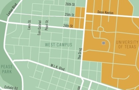
West Campus neighborhood, primarily represented by University Area Partners. Map: The Galileo, rev. by ARN.

West Campus neighborhood, primarily represented by University Area Partners. Map: The Galileo, rev. by ARN.

Back in November, in the midst of all the uproar over problems with Project Connect’s “Central Corridor” study and forthcoming route “recommendation”, this blog missed reporting that yet another major neighborhood association had jumped on board the effort to designate the Guadalupe-Lamar (G-L) corridor as the preferred starter-line route for urban rail (light rail transit).

On Nov. 12th, the University Area Partners (UAP) neighborhood association voted to express its belief “that any first investment in light rail must serve as an expandable backbone of rapid transit, and such an alignment is most suited along North Lamar Blvd. and Guadalupe Street and terminated at or near the North Lamar Transit Center ….”

The University Area Partners is a neighborhood organization representing business, institutions, and property owners in the University of Texas area, encompassing most of West Campus, UT-Austin, and The Drag area.

According to UAP member John Lawler, reasons the UAP board decided to support the G-L alignment include:

• Prioritizing urban rail along the G/L corridor would better serve the steadily growing and already dense West Campus neighborhood
• UAP wants to support the UT Student Government position, as students are the primary residents in the area
• CANPAC, the planning area UAP is an original member of, has endorsed the plan
• BRT is not a solution for the Drag’s traffic congestion and the neighborhood has repeatedly encouraged rail development for the past several decades

The endorsement of this influential neighborhood organization is especially important because, in terms of residential density, the West Campus ranks as the third or fourth-highest neighborhood among major Texas cities.

Yet, while Project Connect’s recent “Central Corridor” study used the metrics of Guadalupe and the West Campus area in its justification and analysis, its proposed “sub-corridor” configuration would effectively bypass this crucial area, instead planning an alignment on San Jacinto, one-half to three-quarters of a mile east of the Drag and West Campus neighborhood.

h1

Amsterdam’s Leidsestraat shows how interlaced (gauntlet) track can help squeeze light rail into a narrow alignment

13 October 2013
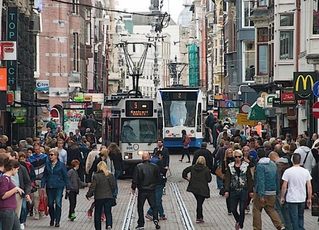
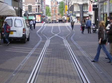
Amsterdam's Leidsestraat shows how gauntlet track allows bidrectional light rail operation in a very narrow alignment, even with very close headways. Also remarkable is how smoothly, efficiently, peacefully, and safely the tram line blends in with, complements, and serves all the pedestrians who walk alongside, behind, and even in front of the trams.

Amsterdam’s Leidsestraat shows how gauntlet track allows bidrectional light rail operation in a very narrow alignment, even with very close headways. Also remarkable is how smoothly, efficiently, peacefully, and safely the tram line blends in with, complements, and serves all the pedestrians who walk alongside, behind, and even in front of the trams. Photo: Roeland Koning .

by Dave Dobbs

In the recent posting How urban rail can be installed in the Guadalupe-Lamar corridor (Oct. 10th), Lyndon Henry discussed how urban rail in the Guadalupe-Lamar (G-L) corridor could deal with right-of-way constraints. For especially confined, narrow stretches, Lyndon suggested that interlaced, or gauntlet, track was an option.

Basically, gauntlet track works like a single-track section, but it doesn’t require movable switchpoints. Instead, it’s completely stationary, with one track in one direction overlapping, or interlacing, with the track in the opposite direction. Then, when the right-of-way becomes wider, the two tracks divide back into separate tracks in each direction again.

To expand on what Lyndon has explained about dealing with constrained rights-of-way (ROW) and the use of interlaced or gauntlet track, probably it’s helpful to focus on perhaps the most famous example — the Leidsestraat, a very narrow street in Amsterdam. This is a city filled with trams (aka streetcars, light rail).

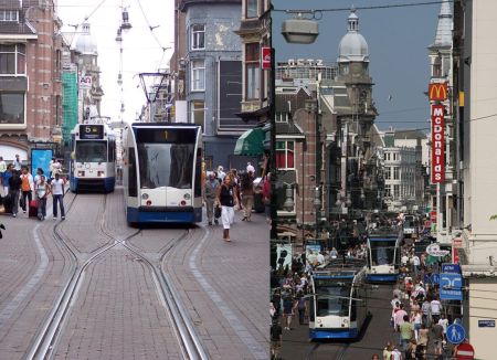
Two views of the Leidsestraat. LEFT: A #1 tram, heading away from camera, has just left the interlaced section onto double track, passing a #5 tram headed toward the camera and the interlaced section. (Photo: Stefan Baguette) RIGHT: You can see the stead stream of trams, sometimes just a couple of minutes apart, passing the heavy flows of pedestrians on each side. (Photo: Mauritsvink)

Two views of the Leidsestraat. LEFT: A #1 tram, heading away from camera, has just left the interlaced section onto double track, passing a #5 tram headed toward the camera and the interlaced section. (Photo: Stefan Baguette) RIGHT: You can see the steady stream of trams, sometimes just a couple of minutes apart, passing the heavy flows of pedestrians on each side. (Photo: Mauritsvink)

In Europe, the tramway is basically surface electric urban rail ­(light rail transit) that can adapt like a chameleon — it is what it is, wherever it is. Flexibility is its trademark and it’s designed to fit within a budget.

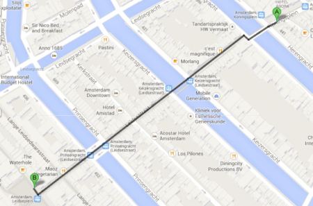
The Leidsestraat is about a third of a mile long in the center of the city and is home to three GVB (transit agency) tram lines running bi-directionally two to three minutes apart (see map below). Trams run constantly back and forth, sharing the gauntlet (interlaced) sections one at a time, and passing one another where the tracks branch out into double-tracked sections, where the street appears to be less than 40 feet (12-13 meters) wide.

Leidsestraat alignment runs about 500 meters (0.31 mile) in length, passing over several canals.

Leidsestraat alignment runs about 500 meters (0.31 mile) in length, passing over several canals. Map: Dave Dobbs (from Google Maps).

Light rail operation in the Leidsestraat is even more remarkable when you consider that it’s one of the busiest autofree streets in the world, teeming with pedestrians and bicyclists (as you can tell from the photos). Motor vehicles are allowed very limited access to serve retail stores, restaurants, and other businesses. Besides how well gauntlet track works with relatively close headways, allowing light rail trains to access this extremely narrow urban street, is how smoothly, efficiently, peacefully, and safely it blends in with, complements, and serves all the pedestrians who walk alongside, behind, and even in front of the trams.

The following are some additional photos of light rail tramway operation along this alignment


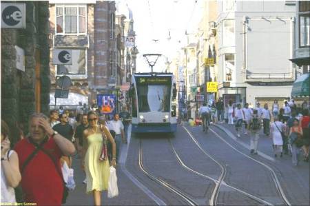
Another photo showing crowds of pedestrians, an approaching tram, and a clearview of a transition from double-track to interlaced track. (Photo: Marc Sonnen.)

Another photo showing crowds of pedestrians, an approaching tram, and a clearview of a transition from double-track to interlaced track. (Photo: Marc Sonnen.)


Focus on interlaced track construction in the Leidsestraat. Notice how the two tracks  Notice how the two tracks virtually merge to form what almost seems like a single track — but there are separate parallel rails for each direction, laid next to each other. Also, only one rail in each direction actually cross each other (this type of passive, stationary rail crossing is called a frog).

Focus on interlaced track construction in the Leidsestraat. Notice how the two tracks virtually merge to form what almost seems like a single track — but there are separate parallel rails for each direction, laid next to each other. Also, only one rail in each direction actually crosses the other (this type of passive, stationary rail crossing is called a frog). Photo: Revo Arka Giri Soekatno


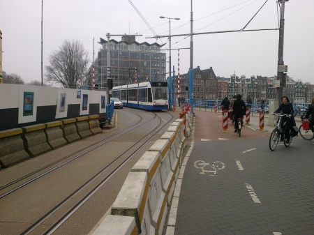
Interlaced track is also used in other narrow locations, some shared with motor vehicle traffic. Here a Route 10 tram leaves the interlaced track over the Hoge Sluis bridge, as an autombile waits to proceed over the same right-of-way.

Interlaced track is also used in other narrow locations, some shared with motor vehicle traffic. Here a Route 10 tram leaves the interlaced track over the Hoge Sluis bridge, as an autombile waits to proceed over the same right-of-way. (Photo by TobyJ, via Wikipedia.)


Here’s an excellent 2-minute video showing trams operating in both directions into and out of one of the interlaced sections through the Leidsestraat.

Original YouTube URL:
http://www.youtube.com/watch?v=Gv9Vgo_W0HU

For further information, this link to Wikipedia’s article on Trams in Amsterdam may be helpful:

http://en.wikipedia.org/wiki/Trams_in_Amsterdam

Special thanks to Roeland Koning and his Studio Koning photography service for his kind permission to use his photo of the Leidsestraat at the top of this posting. Visit his website at:

http://www.studiokoning.nl

h1

UT Student Government backs West Campus, Guadalupe-Lamar route for first phase of urban rail

12 October 2013
West Campus neighborhood is area in light green just to west (left) of the Drag (Guadalupe, vertical white line just to right of center). UT campus shown in orange. Map: The Galileo, rev. by ARN.

West Campus neighborhood is area in light green just to west (left) of the Drag (Guadalupe, vertical white line just to right of center). UT campus shown in orange. Map: The Galileo, rev. by ARN.

The effort to reset Austin’s urban rail planning focus onto the Guadalupe-Lamar (G-L) corridor got a huge boost on October 1st with the University of Texas Student Government’s passage of a resolution endorsing a West Campus and Guadalupe-Lamar corridor alignment for the Phase 1 starter line of urban rail — thus implicitly rejecting the officially proposed East Campus alignment and route out to the Mueller redevelopment site.

Designated as AR 15, the resolution contains a number of “Whereas” clauses, with meticulous documentation of the facts and arguments underpinning the basic decisions. For example, the resolution notes that

…Future-use plans for neighborhoods that include significant student populations, including the Brentwood/Highland Combined Neighborhood Plan , the North Loop Neighborhood Plan, Central Austin Combined Neighborhood Plan, and Hyde Park Neighborhood Plan support urban rail and stations along the proposed Guadalupe-Lamar alignment; and,

… there has been over $30 million worth of studies that have looked at the feasibility of light rail transit along the Guadalupe-Lamar Corridor since the 1970s; and,

… A 2011 study at the University of California-Berkeley found that “light-rail systems need around 30 people per gross acre around stations and heavy rail systems need 50 percent higher densities than this to place them in the top one-quarter of cost-effective rail investments in the U.S.” and “the ridership gains from such increases…showed, would be substantial, especially when jobs are concentrated within ¼ mile of a station and housing within a half mile”; and,

… the largest concentration of students living off campus, West Campus, is the third-densest population district in the state of Texas with a density of over 25,000 people per square mile; and,

… a large majority of the student population along with a vast majority the Central Austin population lives along the proposed Guadalupe-Lamar alignment, totaling over 54,000 people within a quarter-mile to proposed stations ….

On the basis of this evidentiary background, declares the resolution,

BE IT RESOLVED, That the Student Government of the University of Texas at Austin is in full support of the first phase of light rail running through the Guadalupe-Lamar Sub-Corridor; and,

BE IT FURTHER RESOLVED, That Student Government will support any proposed urban rail line that prioritizes transportation access to where students are currently living….

The full resolution can be accessed as a DOC file:

UT-Stu-Govt_AR 15 – In Support of The Guadalupe-Lamar SubCorridor as Phase I of Austin Urban Rail

Certainly, if this vote by UT’s Student Government is any guide, the majority of UT students want an urban rail route to serve the West Campus, where they can most effectively use it.

h1

How urban rail can be installed in the Guadalupe-Lamar corridor

10 October 2013
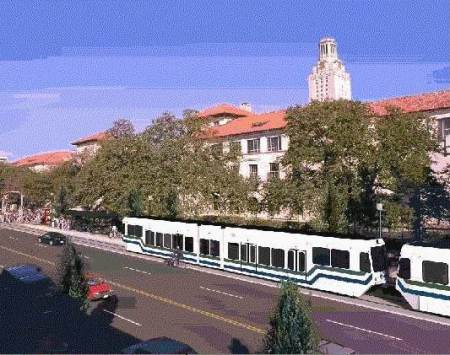
Except for the the somewhat clunkier styling of the railcars, this 2000 simulation of what light rail transit might look like on the Drag is not that different from one of the options today. Graphic: Light Rail Now collection.

Except for the the somewhat clunkier styling of the railcars, this 2000 simulation of what light rail transit might look like on the Drag is not that different from one of the options today. Graphic: Light Rail Now collection.

by Lyndon Henry

Some supporters of the Guadalupe-Lamar (G-L) corridor for Austin’s urban rail starter line have been seeking details about how urban rail (i.e., light rail transit, or LRT) would be installed in these thoroughfares — running in mixed traffic, in reserved lanes, or how? At about the same time, proponents of the Official (aka City of Austin-Capital Metro) proposal for an urban rail line from downtown to Mueller have recently begun raising the issue of right-of-way (ROW) constraints in this same G-L corridor.

It’s important to keep in mind that the Mueller proposal itself has its own ROW constraints and other challenges, but I think it would be helpful here to address some of the issues in the G-L corridor. One of the reasons for this is that I’m not convinced that all parties in the Project Connect team will necessarily make a good-faith effort to find a truly workable, affordable design for inserting urban rail into the G-L thoroughfare alignments — and advocates need to be prepared to insist that valid (and proven) alternatives be examined.

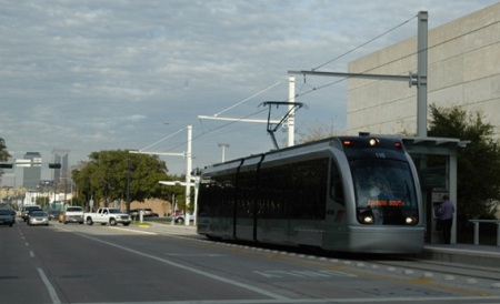
The basic idea is for urban rail (light rail transit, LRT) to operate totally, or almost entirely, in its own lanes. This would require some reconstruction of Lamar Blvd. and probably Guadalupe St. in sections, including slight narrowing of existing lanes, elimination of the turning (“chicken”) lane and replacement with transit-integrated traffic controls (such as left turn lanes), and other measures. Light rail systems in places like Portland, Dallas, Houston, Phoenix, Denver, Salt Lake City, etc. are models for this.

Having crossed intersection, Houston LRT train accesses station on Fannin St. as traffic control system allows queue of motor vehicles to make left turn over track reservation behind it.

Having crossed intersection, Houston LRT train accesses station on Fannin St. as traffic control system allows queue of motor vehicles to make left turn over track reservation behind it. Photo: Peter Ehrlich.

Also keep in mind that Project Connect’s longer-range plan for buses on Lamar-Guadalupe is to install tens of millions of dollars’ worth of reserved lanes — so official planners are already prepared to bite a bullet on this basic issue. What advocates of urban rail in the G-L corridor are saying is that it makes a lot more sense to install reserved lanes for rail rather than buses.

It’s possible that there might be a short section of LRT in mixed traffic (one or both tracks). Sacramento’s LRT operates with this kind of compromise (for about a mile along 12th St., approaching the city’s downtown from the northwest), and has done so for the past 26 years — see Advantages of Light Rail in Street Alignments.
https://austinrailnow.wordpress.com/2013/04/22/advantages-of-light-rail-in-street-alignments/

Sacramento's LRT shares one lane with traffic along 12th St.

Sacramento’s LRT shares one lane with traffic along 12th St.

There’s a very narrow section on the Drag (especially in the 24th-29th St. area) that might require, totally or partially, something like an interlaced (“gauntlet”) track (i.e., two tracks overlapping each other). This would operate effectively like a single-track section but could be fitted into 5-minute headways and possible shorter. (In Amsterdam, interlaced track is even used with 2-minute headways. More on this rail design configuration in a subsequent posting.)

Further downtown, south of MLK Blvd., it would be logical for the double-track line on Guadalupe to split into two single-track lines — southbound on Guadalupe, northbound on Lavaca St. However, it’s likely that LRT would need its own priority lanes in these streets.

Here’s why: The “Transit Priority Lanes” now being installed on the Lavaca and Guadalupe street pair already seem to present major problems for MetroRapid bus, much less LRT. The reason: Official plans involve inserting MetroRapid into a single lane each way along with well over two dozen bus routes. The City’s own 2011 study of this warned that delays to transit might result. And that’s even before urban rail comes along.

It seems eminently reasonable that LRT would need its own reserved lanes on the opposite side of each street (Lavaca and Guadalupe) from the bus lanes. It’s possible that urban rail could perhaps share lane use with MetroRapid, but not with all those other routes.

Since MetroRapid buses can operate only on the righthand side of the street, these buses (with righthand-side doors) couldn’t share a “lefthand” lane with urban rail on the opposite side of each street. So the solution seems to come down to reserving an additional lane exclusively for urban rail on each street.