Posts Tagged ‘streetcar’

h1

Derailing the Mueller urban rail express — Preamble to Project Connect’s 2013 “High-Capacity Transit Study”

2 November 2014
Urban rail concept started as a plan for a streetcar "circulator" system, shown in this early map from 2006. Map adapted from Austin Chronicle.

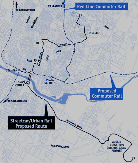
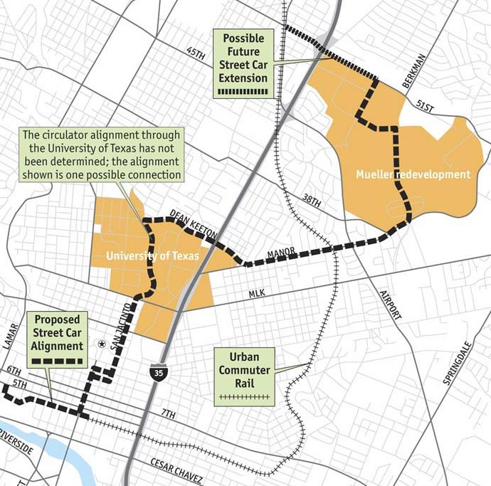
Urban rail concept started as a plan for a streetcar “circulator” system, shown in this early map from 2006. Map adapted from Austin Chronicle.

To understand the roots of the Highland-Riverside urban rail plan on the ballot today, you need to understand how an official “express train” planning process, aiming to lock in an urban rail line to the Mueller redevelopment site, got derailed and sidetracked by community intervention. Here’s a very abbreviated version of the story.

Austin’s current “urban rail” planning arose ca. 2005-2006 following the November 2004 voter approval of Capital Metro’s “urban commuter rail” project, in a package (including “rapid bus” service) called All Systems Go proposing the operation of DMU (diesel multiple-unit) railcars between downtown and the suburb of Leander. The previous light rail (i.e., urban rail) plan for a line on Guadalupe, North Lamar, and the railway alignment northwest as far as McNeil had been shelved in mid-2003 in favor of the cheaper, but very bare-bones, DMU plan.

Since the newly approved DMU line ran on a railway alignment that bypassed most of the heart of the city, ending only at the southeast corner of the CBD, officials and planners realized they needed some way to connect passengers with key activity points, including UT and the Capitol Complex. The answer they devised was a “circulator” system using streetcar technology, which would intersect with the DMU line (eventually rebranded as MetroRail) and connect to downtown Austin, the east side of the Capitol Complex, the East Campus of UT, and the Mueller development site. (See map at top of post.)

But, critics asked, what about the dense West Campus neighborhood and the busy commercial district on The Drag? What about the original plan for light rail along Guadalupe and Lamar? The “rapid bus” service included in the All Systems Go package, intended as a precursor to rail in the Guadalupe-Lamar corridor, was then viewed only as a temporary “fix”, and it seemed clear that rail needed to be planned for that corridor as well.

Within Capital Metro, Lyndon Henry (then a Data Analyst with the transit agency) pressed the case for at least an initial rail line to serve The Drag and West Campus, and at public meetings on the proposed “circulator” Henry and others continued to raise the issue. In this period, as problems emerged with the MetroRail project, Capital Metro’s involvement in the streetcar project was superseded by the City, which assumed control. When Henry’s supervisor Matt Curtis left Metro to become an aide to Mayor Lee Leffingwell, for a brief period a West Campus spur did appear in City of Austin planning maps for the proposed streetcar. (Henry is currently a contributing editor to this website.)

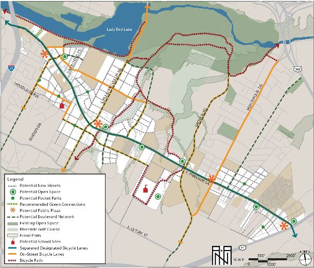
In 2008, as a line on East Riverside to ABIA, with a bridge over the river into the CBD, was proposed, planners became convinced that capacity and speed required fullsize light rail transit (LRT) rolling stock. However, apparently to distinguish the emerging plan from the original, centrally routed Guadalupe-Lamar line, and to retain some of the supposed lower-cost ambience of streetcar technology, the expanded system was dubbed “urban rail”, supposedly a hybrid between a streetcar and a rapid LRT system. By 2010, the Central Austin Transit Study (CATS), prepared by a consortium headed by URS Corporation, recommended a system that stretched from the Mueller site, down Manor Rd. and Dean Keeton to San Jacinto, then south through the East Campus, across the river, and out East Riverside to ABIA. Alternative alignments were suggested, and spurs to Seaholm and the Palmer Auditorium area were also proposed as later extensions.

As the project made its way through the National Environmental Protection Act (NEPA) process, and afterward, the route structure gradually solidified; for a connection to Mueller, a preference was emerging to move the alignment from Manor Rd. to a route via Red River and Airport Blvd. But even the gesture of a spur connection to the West Campus began to vanish, prompting Lyndon Henry and the Light Rail Now Project to call attention to the need for urban rail in the “Missing Link” — the gap between MetroRail’s station at Crestview and North Lamar, and its terminus downtown. Because of that gap, not only were passengers inconvenienced by having to transfer to buses to access their destinations along the Guadalupe-Lamar corridor, but also Capital Metro was running costly bus shuttles to connect MetroRail stations on the east side to the UT campus and the Capitol Complex. See: Give priority to “Missing Link”.


MetroRail Red Line (red) skirts entire heart of central Austin, illustrated by "Missing Link" through Guadalupe-Lamar corridor. Urban rail would provide the crucial connections to core neighborhoods, UT West Campus, and Capitol Complex missed by MetroRail. Infographic Map by Light Rail Now.

“Missing Link” urban rail (green), in Guadalupe-Lamar corridor, would provide the crucial connections to core neighborhoods, UT West Campus, and Capitol Complex missed by MetroRail (dashed red line). Infographic Map by Light Rail Now.


But why had the West Campus, and Guadalupe-Lamar, disappeared from the official urban rail plan? As Henry, Dave Dobbs, Andrew Clements, Roger Baker, and others persistently raised this issue, mainly at meetings of the Transit Working Group (a blue-ribbon committee of civil leaders nominally attached to CAMPO, the Capital Area Metropolitan Planning Organization), planners and officials under the aegis of the Project Connect public agency consortium pointed to a Route Alternatives Evaluation Process included in the 2010 CATS project that had supposedly ruled out a “University of Texas (UT) to North Central Austin (Hyde Park)” route, instead giving top scores to routes serving Mueller, East Riverside, and Seaholm — basically, what City policy actually wanted.

Scrutinizing the “Route Alternatives Evaluation”, Henry identified serious methodological drawbacks and summarized these in a commentary, City’s Urban Rail “alternatives analysis” omitted crucial Lamar-Guadalupe corridor! presented to the TWG on 27 April 2012. These problems are also discussed in our article City’s 2010 urban rail study actually examined corridors! But botched the analysis… (26 November 2013). Basically, the 2010 “evaluation” totally ignored the Guadalupe-Lamar corridor, and “evaluated” an array of alternatives with subjective ratings of 1, 2, or 3. Thus, voila! The preferred official routes, including the route to Mueller, won the “competition”!


CATS map of actual potential rail corridors studied. Map: COA and URS.

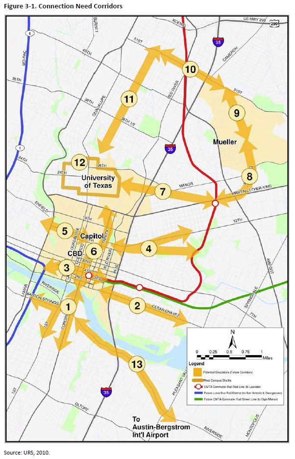
CATS map of potential rail corridors studied — but Guadalupe-Lamar was omitted! And subjective scoring system facilitated ratings that favored City’s desired route plan. Map: COA and URS.


In what seemed like an Urban Rail Express to Mueller, by May 2012, the official urban rail proposal had gelled into a Phase 1 project running 5.5 miles from downtown, through UT’s East Campus via San Jacinto, then northeast via Red River St., 41st St., and Airport Blvd. into the Mueller site. The total investment cost was estimated to be $550 million.


Finalized in May 2012, 5.5-mile, $550-million Phase 1 urban rail starter line was proposed to connect downtown, UT East Campus, Hancock Center, and Mueller site. Graphic: Project Connect.

Finalized in May 2012, 5.5-mile, $550-million Phase 1 urban rail starter line was proposed to connect downtown, UT East Campus, Hancock Center, and Mueller site. Graphic: Project Connect.


But the constant pounding by community critics — especially Lyndon Henry’s exposé of the outrageously dubious Route Alternatives Evaluation from 2010 — was taking its toll. The result was that Project Connect placed the Mueller Phase 1 plan on hold and shifted course dramatically. In early 2013, Kyle Keahey was hired as Urban Rail Lead to head a new “High-Capacity Transit Study”, tasked with supposedly re-evaluating everything, racing through a process (with a presumably more competent and defensible methodology) that would result in a recommendation by the end of 2013.

To some, it seemed a new beginning and a possibly more hopeful and fair approach to analyzing travel corridors, particularly the heavily traveled, high-density, and widely popular Guadalupe-Lamar corridor. Unfortunately, that was not to happen. As it proceeded, it became increasingly clear that the much-vaunted “High-Capacity Transit Study” was actually a fraud. The highlights of this process will be summarized in a subsequent report. ■

h1

Baker: Connecting some dots on Austin’s urban rail planning

24 August 2014
Graphic by ARN.

Graphic by ARN.

By Roger Baker

Roger Baker is a longtime Austin transportation, energy, and urban issues researcher and community activist. The following commentary has been adapted and slightly edited from his comments posted by E-mail to multiple recipients in June.

How did Project Connect come up with their $1.4 billion rail plan? Let’s take some known facts, and connect the dots. The dots in this case were partly the political momentum behind a new hospital district, combined with a new Opportunity Austin/Chamber-of-Commerce-recommended Austin growth policy.

We know that in 2008, a city consultant, ROMA, recommended that the proposed light rail corridor be moved east to the San Jacinto Corridor (ultimately connecting several years later to the Red River corridor), as opposed to the previously-assumed Lamar Corridor alignment. See, for example:

http://www.austinchronicle.com/news/2008-04-25/616178/


Original urban rail "circulator" system in 2008 map of ROMA consulting team plan, contracted by City of Austin.

ROMA streetcar circulator map from 2008, precursor of urban rail (light rail transit) plan. Map: ROMA, via Austin Chronicle. (Click to enlarge.)


Next, we know that State Sen. Kirk Watson in 2012 announced a plan to develop about $4 billion of future medical facilities and training in the area of Brackenridge and the newly announced Dell medical training center, which would be along this same San Jacinto-Red River corridor. It is pretty obvious that to meet this ambitious goal, to handle this scale of future anticipated development, the existing roads along this corridor could not meet the projected travel demand. I pointed that out in an earlier article here:

http://www.theragblog.com/metro-roger-baker-the-proposed-austin-light-rail-plan-as-i-see-it/

How did the urban rail plan get to Riverside? Here is a downloadable audio clip with Project Connect personnel pointing out that the city sees itself as having an unfunded mandate to provide rail on the Riverside alignment in order to meet the city’s future growth goals in that area:

https://docs.google.com/file/d/0B9kg5NdhKh8RYTM0dzQ4ampmeWs/edit


East Riverside development plan, promoted by City, is a bonanza for powerful real estate development interests. Gentrification is replacing lower-cost affordable apartments with expensive condos and upscale commercial and office developments, many with premium river views. Map: City of Austin via Goodlife Realty.

East Riverside development plan, promoted by City, is a bonanza for powerful real estate development interests. Gentrification is replacing lower-cost affordable apartments with expensive condos and upscale commercial and office developments, many with premium river views. Map: City of Austin via Goodlife Realty. (Click to enlarge.)


Another problem for the medical district was that Texas state funding could not pay for the medical center without a big boost from local Travis taxpayers. This demanded the promotion of a hospital district tax. See, for example:

http://www.kirkwatson.com/the-med-school-solution/

…Ever since Austin state Sen. Kirk Wat­son first unveiled the idea at a Real Estate Council of Austin event last September, regional agencies and governments have scrambled to find funding possibilities for the massive project, which could run the involved parties (all told) as much as $4.1 billion over 12 years. At last check, the University of Texas is on board for at least a $25 million annual contribution that would climb to $30 million over the first eight years of the school’s existence. Central Health, according to the Statesman, would cough up about $35 million annually over 12 years – or a total of $420 million. The Seton Healthcare Family expects to provide nearly $2 billion, including $250 million that would ultimately result in a replacement of its aging but centrally located Brackenridge hospital facility…

But to make it all work, Central Health is asking for a tax increase, to be placed before voters on Nov. 6. Watson asked for a raise of five cents per $100 of property valuation; Central Health’s board obliged, endorsing that increase, which would bring the district’s rate to just over 12 cents for every $100 of property valuation. In dollar figures, that would mean (if voters approve) that someone who lives in a home valued at $200,000 would see an increase of $100 on their annual tax bill…


Simulation of future UT medical school development, providing expansion opportunities for University of Texas, Seton medical interests, and other real estate development investors. Graphic via KUT.org.

Simulation of future UT medical school development, providing expansion opportunities for University of Texas, Seton medical interests, and other real estate development investors. Graphic via KUT.org. (Click to enlarge.)


We know from the following document that the city of Austin is bending over backwards to maximize Austin area growth through relocation, and jobs recruitment to the Austin area.

http://www.austintexas.gov/news/city-releases-report-economic-incentives

As we can see, the City has a very well-developed industrial recruitment policy outlined in this document, which coordinates with the Chamber of Commerce, targets key industries to recruit, and gives tax breaks when certain criteria are met. The city takes its lead from the “Council Special Committee on Economic Incentives”, which in turn takes its lead from Opportunity Austin, and the Austin Chamber of Commerce, as we see in this lengthy presentation. It begins by lamenting Austin’s slow growth!

http://austintx.swagit.com/play/08272012-504

We now see unsigned blogs promoting the same maximum Austin growth recruitment as official policy:

http://www.austintexas.gov/department/about-imagine-austin

What are the specifics of Austin growth recruitment policy? The policy is to prefer that at least 25% of the jobs recruited into this area go to Austin residents, but if not, it is no deal breaker. Jobs that pay at least $11 an hour would be nice, but this too is considered optional. This is taken from page 9.

http://www.austintexas.gov/sites/default/files/files/EGRSO/EGRSO_Report_on_ED_Policy_Final.pdf

REPORT AND RECOMMENDATIONS ON THE COA ECONOMIC DEVELOPMENT POLICY

Motion #5:

Change the Threshold for Extraordinary Economic Impact within the Firm-Based Matrix to include other items

The Threshold for Extraordinary Economic Impact has been used within the Firm-Based Incentive Matrix as a means for providing additional economic incentives for significant economic development projects.

Currently, if a company meets one of the four criteria within this section of the matrix, then the company is eligible for an economic incentive of up to 100% of the property tax generated by the project (see Exhibit A, Section 3 and Section 4).

Current threshold criteria include these four items:

• The firm is in a targeted industry;
• The firm is involved in leading edge technology;
• State economic development funds are available for the firm; or
• The firm will generate 500 jobs or more.

The threshold criteria allow flexibility for various economic incentive options to be considered for projects that have an extraordinary economic impact. The flexibility allows Austin to remain competitive for highly sought after projects. Examples of prior significant economic development projects include Samsung and Apple. In both cases, the Austin City Council approved 100% property tax rebates for a prescribed number of initial years…

This is all predicated on the perpetuation of the Austin tech bubble, which is really a regional manifestation of a national tech bubble. Continuing Federal Reserve stimulus is leading to asset bubbles, which are reflected in the NASDAQ’s mostly-tech growth in particular. How long before the tech bubble driving Austin’s current feverish growth and gentrification deflates is anyone’s guess, as Fortune recently pointed out:

http://fortune.com/2014/05/08/yes-were-in-a-tech-bubble-heres-how-i-know-it/

I have recently pointed out and discussed in detail the unsustainable nature of Austin’s currently-booming growth here:

http://www.theragblog.com/metro-roger-baker-the-rise-and-rise-of-austin/

This accumulation of material may help to provide a plausible political basis behind Project Connect’s rail plan. I personally have little doubt that Austin is in the midst of an unsustainable high tech growth bubble, and that the future travel demand numbers that Capital Area Metropolitan Planning Organization (CAMPO) feeds Project Connect to justify its rail corridors are largely wishful thinking. Demographic forecasting, like economic forecasting, exists to make astrology look good by comparison. ■

h1

City-funded 2008 Downtown Austin Plan explained why urban rail better choice than bus

23 January 2014
Back in 2008, City of Austin hired Roma Design Group as lead consultant to design urban rail starter system plan and promote benefits of light rail over bus services. PPT title page screenshot: L. Henry.

Back in 2008, City of Austin hired Roma Design Group as lead consultant to design urban rail starter system plan and promote benefits of light rail over bus services. PPT title page screenshot: L. Henry.

Are Project Connect, the City of Austin (COA), and Capital Metro all starting to get cold feet over advancing an urban rail project?

The first suggestion of this came a few months back, as Project Connect’s Urban Rail Project (with Kyle Keahey designated the Urban Rail Lead) morphed into a so-called “High-Capacity Transit” project.

Then, more recently, there have been more frequent and persistent hints and hedging statements by local officials and transit planners referring to vague “high-capacity transit” … plus a sudden, more emphatic shift into extolling the bountiful benefits of so-called “bus rapid transit” (“BRT”). And now there are all these sudden cautions from various City and Project Connect personnel that maybe, possibly, urban rail may be off the table for much of the “East Riverside to Highland” route now in official favor.

Particularly significant is the intensified emphasis with which Project Connect’s Urban Rail Lead (should he now be re-designated “High-Capacity Transit Lead”?) Kyle Keahey — and Mayor Lee Leffingwell — have been suddenly brandishing “BRT” (as applied to the rather mundane MetroRapid upgraded-bus service) as an exciting “high-capacity transit” possibility for East Riverside and even the so-called “Highland” route. Along with this, there’s been repeated lecturing to Central Austin neighborhoods along the West Campus-Guadalupe-Lamar corridor as to how fortunate they are to have the MetroRapid service.

And of this all in the context of recent revelations that Urban Rail Lead Keahey has, on record, apparently favored “BRT” over rail transit for at least several years. See: Kyle Keahey, Urban Rail Lead, hypes “BRT” as “more affordable…more flexible investment” than rail.

This sudden switch, from the promotion of rail over the past eight years, to disparaging rail and exalting bus transit, stands in stark contrast to arguments repeatedly presented in City-sponsored presentations for most of the past decade. This case for rail per previous policy is exemplified in a 24 July 2008 Austin City council briefing under the Downtown Austin Plan (DAP) delivered by a consultant team under contract to the City, led by ROMA Design Group in a consortium also including LTK Engineering, Kimley-Horn, HDR/WHM, Studio 8, CMR, HR&A, and Group Solutions.

The PPT presentation, titled “Why Rail, and How Can it Work in Austin?” not only explained the background of the DAP and the team’s latest findings, but also addressed the usual questions over why the team were recommending a rail transit system (envisioned as a streetcar at that point) plus how and why it would be superior to simply running bus service.

In the second major section of the presentation, “Why Rail, and How Can it Work in Austin?” this case is made in a slide headed “Passengers prefer rail because of increased comfort and greater capacity.” As you can see in the screenshot below, the ROMA team noted that rail transit has shown a “Proven increase in ridership over bus-only cities”, has influenced the “Most significant decrease in automobile trips and parking”, is associated with a “Reduction in operating cost per passenger”, and is “More sustainable”, and in addition, “Fixed routes influence land use patterns and promote density” and are “Best suited to corridors where destinations are concentrated”.

Screenshot of slide from ROMA team's Austin City Council briefing.

Screenshot of slide from ROMA team’s Austin City Council briefing.

These same arguments, disseminated by City and Project Connect representatives in many community presentations over the intervening years, are now abruptly being discarded as official planners have apparently begun to distance themselves from urban rail.

The ROMA team’s PPT presentation unfortunately is no longer available on the City’s website, but we’ve uploaded it and you can access the full version here:

Why Rail, and How Can it Work in Austin?

h1

Here’s what a real public meeting on rail transit looks like … in San Antonio

18 October 2013
Kyle Keahey, Project Connect's Urban Rail Lead and a consultant to San Antonio's VIA Metropolitan Transit, speaks during a VIA public meeting discussing San Antonio's modern streetcar plans this past July.

Kyle Keahey, Project Connect’s Urban Rail Lead and a consultant to San Antonio’s VIA Metropolitan Transit, speaks during a VIA public meeting discussing San Antonio’s modern streetcar plans this past July.

As this blog has been reporting, despite promises and assurances to local community leaders and activists who’ve been asking for bona fide public meetings to discuss local urban rail planning, Project Connect can’t seem to make one happen. Instead of real meetings, the Austin community has been offered “open houses”, which we’ve compared to “art galleries”, where people can walk through a room of “pretty pictures” (maps, charts, renderings, etc.), supposedly admiring and considering them and submitting comments or questions to the “guards” (planning personnel standing around). See: Back to “art galleries”! Project Connect reneges on community meetings and Meetings, “open houses”, workshops … and democratic process.

But while urban planners here in Austin haven’t been able to pull together a true public meeting, San Antonio has been holding real meetings — such as the one shown in the photo at the top of this post. And Kyle Keahey, Project Connect’s Urban Rail Lead, is also the lead rail planning consultant to San Antonio’s VIA Metropolitan Transit — and there he is, speaking to a San Antonio community meeting on urban rail!

San Antonio streetcar simulation. Graphic: VIA, from Rivard Report.

This was a meeting sponsored by VIA on 30 July 2013 at San Antonio’s Temple Beth-El to discuss the agency’s downtown modern streetcar project. According to a July 31st report in the San Antonio Express-News, “VIA officials gave more details about the possible streetcar routes, including two new ones ….” As the report noted, the two additional route alternatives “resulted from input from many directions — stakeholders along the route, movers-and-shakers and comment sheets from everyday citizens.” The paper also quotes VIA’s chief development officer’s assurance that “The process is to provide public input.”

And, in contrast to Austin, what has San Antonio got going for it — other than a far more realistic timeframe for decisionmaking, and an authentic official commitment to encouraging community participation?

h1

Amsterdam’s Leidsestraat shows how interlaced (gauntlet) track can help squeeze light rail into a narrow alignment

13 October 2013
Amsterdam's Leidsestraat shows how gauntlet track allows bidrectional light rail operation in a very narrow alignment, even with very close headways. Also remarkable is how smoothly, efficiently, peacefully, and safely the tram line blends in with, complements, and serves all the pedestrians who walk alongside, behind, and even in front of the trams.

Amsterdam’s Leidsestraat shows how gauntlet track allows bidrectional light rail operation in a very narrow alignment, even with very close headways. Also remarkable is how smoothly, efficiently, peacefully, and safely the tram line blends in with, complements, and serves all the pedestrians who walk alongside, behind, and even in front of the trams. Photo: Roeland Koning .

by Dave Dobbs

In the recent posting How urban rail can be installed in the Guadalupe-Lamar corridor (Oct. 10th), Lyndon Henry discussed how urban rail in the Guadalupe-Lamar (G-L) corridor could deal with right-of-way constraints. For especially confined, narrow stretches, Lyndon suggested that interlaced, or gauntlet, track was an option.

Basically, gauntlet track works like a single-track section, but it doesn’t require movable switchpoints. Instead, it’s completely stationary, with one track in one direction overlapping, or interlacing, with the track in the opposite direction. Then, when the right-of-way becomes wider, the two tracks divide back into separate tracks in each direction again.

To expand on what Lyndon has explained about dealing with constrained rights-of-way (ROW) and the use of interlaced or gauntlet track, probably it’s helpful to focus on perhaps the most famous example — the Leidsestraat, a very narrow street in Amsterdam. This is a city filled with trams (aka streetcars, light rail).

Two views of the Leidsestraat. LEFT: A #1 tram, heading away from camera, has just left the interlaced section onto double track, passing a #5 tram headed toward the camera and the interlaced section. (Photo: Stefan Baguette) RIGHT: You can see the stead stream of trams, sometimes just a couple of minutes apart, passing the heavy flows of pedestrians on each side. (Photo: Mauritsvink)

Two views of the Leidsestraat. LEFT: A #1 tram, heading away from camera, has just left the interlaced section onto double track, passing a #5 tram headed toward the camera and the interlaced section. (Photo: Stefan Baguette) RIGHT: You can see the steady stream of trams, sometimes just a couple of minutes apart, passing the heavy flows of pedestrians on each side. (Photo: Mauritsvink)

In Europe, the tramway is basically surface electric urban rail ­(light rail transit) that can adapt like a chameleon — it is what it is, wherever it is. Flexibility is its trademark and it’s designed to fit within a budget.

The Leidsestraat is about a third of a mile long in the center of the city and is home to three GVB (transit agency) tram lines running bi-directionally two to three minutes apart (see map below). Trams run constantly back and forth, sharing the gauntlet (interlaced) sections one at a time, and passing one another where the tracks branch out into double-tracked sections, where the street appears to be less than 40 feet (12-13 meters) wide.

Leidsestraat alignment runs about 500 meters (0.31 mile) in length, passing over several canals.

Leidsestraat alignment runs about 500 meters (0.31 mile) in length, passing over several canals. Map: Dave Dobbs (from Google Maps).

Light rail operation in the Leidsestraat is even more remarkable when you consider that it’s one of the busiest autofree streets in the world, teeming with pedestrians and bicyclists (as you can tell from the photos). Motor vehicles are allowed very limited access to serve retail stores, restaurants, and other businesses. Besides how well gauntlet track works with relatively close headways, allowing light rail trains to access this extremely narrow urban street, is how smoothly, efficiently, peacefully, and safely it blends in with, complements, and serves all the pedestrians who walk alongside, behind, and even in front of the trams.

The following are some additional photos of light rail tramway operation along this alignment


Another photo showing crowds of pedestrians, an approaching tram, and a clearview of a transition from double-track to interlaced track. (Photo: Marc Sonnen.)

Another photo showing crowds of pedestrians, an approaching tram, and a clearview of a transition from double-track to interlaced track. (Photo: Marc Sonnen.)


Focus on interlaced track construction in the Leidsestraat. Notice how the two tracks  Notice how the two tracks virtually merge to form what almost seems like a single track — but there are separate parallel rails for each direction, laid next to each other. Also, only one rail in each direction actually cross each other (this type of passive, stationary rail crossing is called a frog).

Focus on interlaced track construction in the Leidsestraat. Notice how the two tracks virtually merge to form what almost seems like a single track — but there are separate parallel rails for each direction, laid next to each other. Also, only one rail in each direction actually crosses the other (this type of passive, stationary rail crossing is called a frog). Photo: Revo Arka Giri Soekatno


Interlaced track is also used in other narrow locations, some shared with motor vehicle traffic. Here a Route 10 tram leaves the interlaced track over the Hoge Sluis bridge, as an autombile waits to proceed over the same right-of-way.

Interlaced track is also used in other narrow locations, some shared with motor vehicle traffic. Here a Route 10 tram leaves the interlaced track over the Hoge Sluis bridge, as an autombile waits to proceed over the same right-of-way. (Photo by TobyJ, via Wikipedia.)


Here’s an excellent 2-minute video showing trams operating in both directions into and out of one of the interlaced sections through the Leidsestraat.

Original YouTube URL:
http://www.youtube.com/watch?v=Gv9Vgo_W0HU

For further information, this link to Wikipedia’s article on Trams in Amsterdam may be helpful:

http://en.wikipedia.org/wiki/Trams_in_Amsterdam

Special thanks to Roeland Koning and his Studio Koning photography service for his kind permission to use his photo of the Leidsestraat at the top of this posting. Visit his website at:

http://www.studiokoning.nl