Archive for the ‘Austin transportation planning’ Category

h1

Downtown Austin’s Coming Light Rail Service Needs Republic Square Station

23 April 2024
Republic Square station would provide southwest sector of downtown 4-5 minute connectivity to light rail as illustrated by red lines. Graphic: ARN, adapted from original DAA map.

By Lyndon Henry, Editor

Why are urban rail stations in downtowns – central business districts (CBDs) – typically spaced so much more closely than in outlying stretches of rail lines? Of course, one major reason is that more frequent stations are needed to serve the density of these highly compacted activity concentrations – employment density in particular, although population density in city centers, like Austin’s, has also been increasing.

Commuters to downtown jobs will tolerate a longer walk to an outlying light rail transit (LRT) station, or even access of a mile or more to a park & ride. But over a century of experience has shown that most people don’t want to spend much above about five minutes walking to their workplace from their transit stop. Or from their workplace to the nearest transit station, to commute home at the end of a day’s work.

To some extent, in Austin Rail Now’s previous post, these factors are reflected in the map-graphic shown (originally prepared by the Downtown Austin Alliance (DAA) and included in a public document by the Austin Transit Partnership). Using shaded circular areas around several proposed downtown LRT stations, the graphic illustrates a quarter-mile/five-minute walk distance around each station. While the DAA’s graphic bolsters the case for adding a Wooldridge Square station to the LRT plan (an addition we strongly support), it also exposes a large gap in coverage for the southwest segment of downtown.

Republic Square station fills need

This gap can be filled by a Republic Square station (between W. 4th and 5th Streets), as shown in the graphic above (at the head of this article), which we’ve adapted from the DAA map. On our graphic, red lines radiating westward from the proposed station indicate approximate 4 to 5-minute walk distances to points in this area. Southwest downtown includes such major sites as the Federal Courthouse, the Seaholm development (with various shops and restaurants), the Austin Central Library, and several large condo and apartment highrises. The district also includes a multitude of other establishments, such as smaller shops, hotels, restaurants, and more. A Republic Square LRT station would also be just six blocks from the major westside Whole Foods Market.

The need for another downtown station (in addition to stations already proposed by the Project Connect team and the DAA’s Wooldridge Square concept) is highlighted in the following graph comparison of station spacing.  This uses roughly equivalent block lengths in several peer cities (considered quite successful in the industry); the data used for Austin includes the proposed Wooldridge Square station, which Project Connect considers an “option”. This comparison suggests that the downtown station spacing so far proposed for Austin’s coming LRT system seems inconsistent with Best Practices by these typical peer systems.

Even with “optional” Wooldridge station, proposed spacing of Austin’s downtown LRT stops appears to violate Best Practices of several peer city systems. Graphic: ARN.

Easy Interface with current transit hub

In addition to ease of access, another factor typically involved in the layout and spacing of downtown stations is the need to minimize peak crowding and to avoid overcrowding at any station in these high-population areas. Providing too few stations in these situations (which may be indicated by longer stop-spacing) can create excessive crowding that is unpleasant, dangerous, and disruptive to smooth operation and service.

And in regard to the proposed Republic Square station specifically, there’s another major consideration: the opportunity for LRT to interface with the major bus transit hub at Republic Square, which has functioned for years to provide a relatively smooth interface among routes, well-known to the public.

In artistic simulation, a light rail train rolls through Republic Square – but without a station! Graphic: Austin Transit Partnership.

Not only is the Republic Square hub well-established and familiar to the transit-riding community, it’s positioned  six blocks (along 4th St.) from the downtown MetroRail station at the Austin Convention Center, providing a feasible interconnection between MetroRail and the large assortment of bus routes converging at Republic Square. Adding an LRT station here would expand Republic Square’s role into a multi-modal transit hub.

For multiple reasons, a Republic Square station would fill a critical need and eliminate the remaining serious gap in the proposed downtown LRT alignment. But if this gap were to remain in the final plan, we can’t help imagining whether future generations of Austinites will be wondering: “What were they thinking?” And it’s critical to keep in mind here that retrofitting an urban rail station into an existing alignment – particularly in an intensively developed central-city environment – is far more expensive than including it in the original construction project. ■

h1

Downtown Austin Alliance Proposes Additional Downtown Station

16 April 2024
Wooldridge Square Station proposed by DAA, showing connectivity benefits. Source: DAA via Austin Transit Partnership.

By Lyndon Henry, Editor

In my December 18th ARN article, “Downtown Light Rail Plan Needs More Stations”, I explained the need to include additional downtown stations in Project Connect’s revised surface-routed light rail transit (LRT) plan, and specifically recommended adding stations on the Guadalupe St. alignment at Republic Square (W. 4th St.) and W. 10th St. (Wooldridge Square). As I noted, these proposals were developed via my discussions in the previous spring and summer of 2023 with ATP staff and technical advisory committee members; they were eventually presented in a June memo.

As it turns out, the Downtown Austin Alliance (DAA, a consortium of downtown businesses, real estate interests, developers, and related interests) had also perceived the need for at least one additional station – at Wooldridge Square, just as I have also recommended – and included a proposal for such within a memo dated 10 May 2023 to Austin Transit Partnership (ATP) Executive Director Greg Canally. (This is contained in ATP’s Austin Light Rail: Community Engagement Report, a document released publicly in May 2023.)

The Wooldridge Square Station proposal is shown in a graphic map appendix, labeled “Wooldridge Station Connectivity”, illustrating the additional coverage that the station would provide within a ¼-mile radius, and sites of key interest made more accessible by such a station (this is the head map-graphic at top of this post).

As I had pointed out in my own June 2023 memo, Project Connect’s revised plan for downtown was proposing “exceptionally long spacing between stations for a major dense central area, and I believe it is inconsistent with Best Practices ….” DAA’s memo seems to provide some corroboration for this assessment, while emphasizing the enhanced accessibility provided by a Wooldridge Square station:

As currently proposed, the distance between the Congress and 15th Street stations is approximately one mile. We recommend adding an additional station in the vicinity of Wooldridge Square and Sweatt Travis County Courthouse. This would lessen the distance between the Congress and 15th Street stations to less than half a mile and would provide much needed access to courthouses (federal and state), Austin Community College, Pease School redevelopment, Austin History Center, the Paramount and the Old Bakery. It would also facilitate east-west transfers to frequent bus routes at 7th/8th Streets, providing potential congestion relief at Republic Square.

For sure, DAA’s proposal to add a Wooldridge Station represents an important and crucial improvement for the planned downtown LRT alignment. So far, Project Connect and Austin Transit Partnership have presented this as a possible design “option”. Hopefully this will be accepted as a definite element of the plan.

But a Republic Square station is also essential for adequate connectivity and accessibility in Austin’s downtown. The case for this will be presented in a subsequent analysis to be posted shortly. ■

h1

Downtown Light Rail Plan Needs More Stations

18 December 2023
Simulation of LRT train on Guadalupe St. at Republic Square from Project Connect’s revised plan. But so far, the plan does not actually include a station at this crucial downtown transit hub! Source: ATP

By Lyndon Henry, Editor

Austin’s light rail transit (LRT) project continues to progress despite difficulties. The Austin Transit Partnership (ATP) and Project Connect (PC) planning team have so far been able to overcome serious legislative and litigational threats from public transport opponents. Equally important, they’ve managed to navigate through serious budget problems arising from design complications, external economic inflation, and other factors.

It’s a relief at last to have the workable (and hopefully entirely affordable) 3-branch light rail transit (LRT) system plan that ATP has adopted, shown in this map, publicly released this past May, which indicates proposed station locations as well as planned future line extensions:

ATP’s proposed Phase 1 surface LRT plan. Source: ATP

The revised downtown route is a surface alignment following several streets: Trinity St., 3rd St., and Guadalupe St. However, in discussions this past spring and summer with ATP staff and technical advisory committee members, I called attention to a major concern with respect to the small number of stations – just three – to serve both Downtown and the Capitol Complex – i.e., two-thirds of Austin’s critically important Central Area. All three proposed station locations – Cesar Chavez, Congress, and 15th St. – can be seen on this closeup from the map:

Closeup of LRT map with proposed downtown stations (Cesar Chavez, Congress, 15th St,)

This deficit in stations results in a serious problem of inadequate station spacing in this key activity center complex. In particular, there is a 14-block gap (in line length) between the proposed Congress station (located on 3rd St. west of Congress Ave.) and the proposed 15th St. station (on Guadalupe). The route distance (per Google Maps) for this gap between these two stations measures 5,633 feet. That’s 1.1 mile, or 1,717 meters, between these stations.

The following more detailed map graphic, created from Google Maps, facilitates a more accurate assessment of the proposed LRT route and stations within the grid of streets, blocks, and major landmarks, and a better visual sense of the lack of stations along Guadalupe St., resulting in the sizable gap between the proposed Congress and 15th St. stations.

ATP’s proposed downtown LRT route and stations. Source: LH, via Google Maps

This is an exceptionally long spacing between stations for a major dense central area, and it appears to be inconsistent with Best Practices as exhibited by downtown route configurations in peer cities, particularly with central-city surface alignments, such those in as Portland, San Diego, Sacramento, Phoenix, Minneapolis, Dallas, Houston, Denver, Salt Lake City, and others, where spacing typically ranges from 3 to 8 blocks. In fact, I can’t immediately think of any other light rail system in North America with a station spacing that wide in the heart of its downtown.

Transportation consultant Jarrett Walker has discussed the stop-spacing issue on his website, HumanTransit.org: Basics: The Spacing of Stops and Stations.  As Walker notes, “… transit planners generally observe that the walking distance that most people seem to tolerate — the one beyond which ridership falls off drastically —  is about 400m (around 1/4 mi) for a local-stop service, and about 1000m (around 3/5 mi) for a very fast, frequent, and reliable rapid transit service.”

Here, Walker is discussing stop-spacing for a city as a whole. However, it’s crucial to consider the particular factors in play regarding the spacing of stations and adequate access in a downtown or other densely concentrated high-activity area. Given the dense mesh of downtown street structure, a circular radius yardstick doesn’t seem adequately applicable – transit users can’t walk in straight-line radii between worksites and transit stations, they must follow the zig-zag street configuration, which significantly increases total access distance. Plus additional time spent waiting at traffic lights must be taken into account.

Real access time in minutes would probably be a better comparative measure of ease of access. And it’s not just a matter of convenience. This means that excessively wide station spacing in a downtown may impair access, discourage use of the transit service, and thus significantly reduce ridership. It also imposes extra difficulty for the elderly and mobility-challenged. Potentially the problem could also damage public goodwill.

While the Project Connect team has expressed concern about steep gradients on Guadalupe at 5th St. and several blocks north that affect station construction, I note that industry guidelines are not rigid but do allow design to follow existing street gradients where this can be done consistently with safety and Best Practices. (Reference: TCRP Report 155, 2nd Ed. 201; U.S. Access Board, Accessibility Standards.)

Taking into account these considerations, to remedy this (so far publicly presented) 1.1-mile gap in downtown LRT station spacing, on 28 April I proposed that at least two additional downtown stations on Guadalupe St. be added to ATP’s revised surface LRT plan. As illustrated in the small amended map segment presented below, these include a station at 4th/Guadalupe to serve the existing transit hub at Republic Square and the lower west side of downtown, as well as a station at 10th/Guadalupe, intended to improve accessibility to the north end and upper west side of downtown, including the Travis County Courthouse, many legal and professional offices, and the Austin History Center.

Proposed additional downtown stations. Source: LH

ATP personnel indicated that they were considering these proposals, and the broader possibility of adding more downtown stations to the revised LRT plan. So far, no changes have been publicized. ■

h1

Project Connect’s Light Rail-Centered Plan Is a Huge Step Forward

31 August 2020

Simulation of Austin light rail alignment in roadway median. Graphic: Project Connect.

Commentary by Lyndon Henry


The following statement by Lyndon Henry, a technical consultant to the Light Rail Now Project and contributing editor to Austin Rail Now (ARN), was presented as part of Public Comment by phone to a joint meeting of the Austin City Council and Capital Metro Board on 10 June 2020. Subsequently, Project Connect’s plan for a $7.1 billion multi-modal transit system expansion, including two initial light rail lines, has been approved by the Austin City Council and scheduled as a ballot measure for the upcoming election on 3 November 2020.

I’m Lyndon Henry. I launched the concept of light rail transit for Austin with a feasibility study back in 1973. Over the past 47 years I’ve worked to make this crucial public transport system a reality.

As I’ve long pointed out, light rail has unique potential, as a more affordable high-capacity urban rail mode, to attract ridership, provide more cost-effective operation, stimulate transit-oriented development, galvanize the entire transit system, create a more livable urban environment, and mobilize community support.

At last, decades of effort by the City of Austin and Capital Metro, particularly Project Connect, have brought us to today’s monumental plan, centered on light rail with a central spine along the key North Lamar-Guadalupe-South Congress Orange Line corridor as its anchor.

This massive public-works project will provide jobs and help rebuild Austin’s economy when we finally emerge from the pandemic nightmare. Light rail will open exciting possibilities for catalyzing development in the Core Area, especially around the massive proposed subway infrastructure, as well as elsewhere along other corridors. This will provide crucial economic stimulus to create more jobs as well as expand critical taxbase and fund further service improvements.

Thinking well into the future has been a hallmark of Project Connect’s ambitious planning, preparing for future urban growth and transit capacity needs. This critical foresight must be continued with a view to eventual conversion of the Red Line to light rail transit.

The northwest corridor, paralleling US 183, definitely ranks among the heaviest travel corridors in our metro area. Converting the Red Line to more efficient electric light rail would provide huge service improvements, improve cost-effectiveness, and stimulate much higher ridership, especially by offering seamless, transfer-free travel from northwestern communities into Austin’s core. This would also extend electric light rail service to benefit East Austin neighborhoods.

This future improvement needs to be prepared for now, by designing appropriate infrastructure features into the planned Crestview intersection grade separation

I want to thank all of the diverse team involved with Project Connect for listening to so many of us in the community in developing this plan. It is certainly heartening and refreshing to see the results of this long saga of planning and to be able to support such an ambitious and exciting project.

I urge you to designate this plan as Austin’s Locally Preferred Alternative. Thank you.

h1

Austin: To subway, or not to subway?

29 February 2020

Map showing proposed downtown LRT subway. Source: Project Connect.

As ARN reported in our posting of 31 January, Project Connect Connect (Capital Metro’s major transit investment planning program) together with most of Austin’s top civic leadership apparently are now focusing on a massive multi-modal transit development vision with light rail transit (LRT) as its centerpiece, running in both the the Orange Line (North Lamar-Guadalupe-South Congress) and Blue Line (downtown-East Riverside-ABIA) corridors.

As we also noted, ridership volumes projected for the Orange Line are eye-popping – certainly, unusually high levels for a single U.S. starter line in a mid-sized Southwest city. Projected 2040 weekday ridership (61,600 to 73,500) would exceed or rival ridership experienced by the original single lines of relatively new major LRT projects (e.g, Los Angeles, Denver, St. Louis, Dallas, Houston) and even rail rapid transit – “heavy rail” metro – projects (e.g., Philadelphia-Lindenwold, Miami, Baltimore).

These volumes appear to underlie suggestions by Project Connect planners that segments of the proposed LRT lines, particularly in Austin’s Core Area, merit consideration as subway alignments. In addition, a segment of the Blue Line, several blocks eastward, is also considered for subway; it would feed into the Orange Line via an underground junction at Republic Square.

Need for greater capacity

Heavy peak transit passenger flows typically require more frequent trains and longer consists (number of cars per train) to provide sufficient capacity. Especially in concentrated downtowns and other central-city locations, these factors can in turn impact traffic flows across intersections by not just cars and trucks but also pedestrians, cyclists, and transit buses.

Particularly fueling interest is a subway tunnel is the length of downtown blocks (about 300 feet), which would limit train lengths to no more than three coupled LRT cars. This implies the need for a subway alignment in the Core Area north of the Colorado River (known as Lady Bird Lake) and south of Martin Luther King (MLK) Blvd. (basically, the southern border of the University of Texas campus).

In addition to eliminating conflicts with surface traffic and providing adequate capacity well into the future, the case for a subway appears to be bolstered by political support, both among the city’s top civic leadership as well as the public at large.

Subway drawbacks

On the other hand, there are significant drawbacks to subway rather than surface LRT line construction, both generally and in Austin’s case:

• Subway construction typically is far more expensive than surface facilities, entailing a much heavier demand on financial resources. According to cost estimates from Project Connect, building a downtown subway for an Orange Line LRT, rather than installing a surface alignment, would add nearly $837 million to the project investment cost.

• Federal Transit Administration funding is limited, and FTA officials tend to prefer more modest investment grant applications so that available funding can be spread more broadly. Increasing the cost of a New Start project significantly may render a project less competitive and lower it in the queue of projects seeking funding. Adding a downtown subway segment to, say, a starter LRT line from the North Lamar Transit Center to downtown would increase total project cost by over 65%.

• Particularly because the precise details of what’s below the surface are largely hidden, subway construction is far more prone to unexpected challenges and costs which can result in hefty budget overruns.

• Operating & maintenance (O&M) costs for subway LRT operation tend to be somewhat higher than for surface operation because of the added operational costs (e.g., electrical power) and functional maintenance needs of ventilation systems, elevators, escalators, etc. Also, maintenance-of-way work (maintaining track, power supply, signals, etc.) tends to be more expensive in underground conditions.

• Compared to surface LRT, where trains are run in the open and stations are easy to see and recognize – orienting the public to the available service and helping attract potential passengers – subway operations and stations are almost entirely out of sight, except for small entrances to ground level that may be difficult for the general public (especially new riders, tourists, etc.) to find and recognize.

• Access-egress to-from subway stations, which require climbing stairs, waiting for and riding elevators, or riding escalators, can be somewhat daunting. (The access time penalty is often included in ridership forecast models.) While accessing surface LRT platforms often requires waiting for traffic or pedestrian signals, typically the time penalty and physical difficulty are much less.

Capacity of an Orange Line surface LRT line

While there’s no question that a subway would provide greater potential to accommodate ridership further into the future, a technical examination of the capacity requirements to meet Project Connect’s actual predicted peak ridership volumes in the 2040 target year suggests that these could be met by a surface LRT alignment (running in dedicated street lanes) through Austin’s downtown, even with the limitation of 3-car trains running at very narrow headways (i.e., high frequencies). For example, Both Dallas and Calgary (Alberta) operate 3-car trains providing heavy capacity through downtown street alignments. Dallas runs trains as close as 4-min peak headways; Calgary runs trains as close as 2.4-min peak headways. Presumably Austin could operate trains at least as close as 3-min headways, or 20 trains per hour.

Project Connect assumes each LRT car would have a peak capacity of 172 passengers. Thus a 3-car train would provide capacity for 516 passengers. Running 20 three-car trains per hour would provide peak capacity of 10,320 riders per peak hour/peak direction. Using the rule of thumb that peak ridership in the peak direction = 10% of daily weekday ridership, this implies that surface LRT trains would provide an operating capacity capable of handling ridership up to 103,000 a day.

Project Connect forecasts daily ridership of 61,600 for the 90% street-alignment option, and 73,600 for the 50% grade-separated option. Extrapolating from the agency’s estimates, ARN calculates the annual growth rate for Project Connect’s 90% street option to be 2.2% per annum. At that rate, it would take another 24 years to reach 103,000 daily ridership level, or the year 2064 – 44 years from today – when the capacity of street running with 3-car trains would presumably be reached.

While a surface LRT line may provide adequate capacity for several decades into the future, nevertheless it’s virtually guaranteed that eventually it will not be able to meet Austin’s growing transit ridership market at some further point. Should Austin be designing a system for that far into the future? Perhaps, but this “future-proofing” strategy needs to be weighed against other considerations, such as Austin’s available bonding capacity, and the need for such a project to be competitive for relatively scarce FTA capital investment grant funding.

A downtown subway project could still be undertaken at the point of unavoidable need, 40 or 45 years from now. Salvageable surface trackage and facilities could possibly be redeployed for a surface circulator system.

Economic development potential

But capacity and operational characteristics are not the only aspects of such a major urban rail investment to be considered. Light rail – either surface or subway – can be expected to catalyze significant nearby and adjacent economic development that potentially could provide a revenue stream recompensing most, or even all, of the infrastructure investment. The tens of billions of dollars in economic development stimulated by new LRT systems in cities like Los Angeles, Dallas, Portland, Phoenix, Charlotte, Seattle, Minneapolis-St. Paul, Kansas City, Detroit, and others represent abundant evidence of these benefits.

It’s worth imagining that LRT stations (either subway or surface) in downtown Austin could stimulate the development of a major underground/above-ground commercial/shopping complex there, directly connecting with the LRT system. Models of such developments, with stores, small shops and boutiques, theatres, restaurants, and other attractions, can be found in an array of global cities with signature core-area LRT systems or metros, whereby the urban rail system provides fast, easy access to these work, shopping, dining, and recreational opportunities. Several examples include:

• Los Angeles — The Bloc (connecting to Metro and LRT subways)

• Dallas — Dallas Pedestrian Network (underground concourses with shops, food services connecting to DART LRT)

• Toronto — Massive PATH underground shopping complex connecting with six TTC subway stations, including Union Station, the city’s largest transit hub

• Montreal — Underground City, “a multi-level network of tunnels and stairways that connect various shopping malls, metro stations, offices, hotels, libraries, schools, concert halls, and restaurants” (Culture Trip)

• Edmonton — The Pedway, a network of underground concourses and aerial walkways connecting over 40 office buildings, shopping centers, and parking facilities with three LRT stations in the downtown area

And of course there are numerous other examples worldwide of similar downtown complexes integrated with urban rail stations.

Whether Project Connect’s final plan includes a subway or not, the opportunity to design Austin’s LRT stations to catalyze economic development must be a major element. And especially with this city’s role as an internationally known venue for events such as SxSW, ACL, and Formula One, the chance to transform and enrich downtown with such a major integrated complex of activity centers with urban rail should not be missed.

h1

Project Connect’s Orange Line operating cost assumptions seem to fail plausibility test

3 December 2019

Cover of Project Connect’s O&M cost methodology and assumptions report. Screen capture by ARN.


This analysis has been adapted and revised from comments originally posted to the #ATXTransit listserv by Lyndon Henry, a technical consultant to the Light Rail Now Project and contributing editor to Austin Rail Now (ARN).

For approximately the past year, Capital Metro’s planning program, Project Connect, has been analyzing two travel corridors for major high-capacity rapid transit investment – the Orange Line (basically following the North Lamar-Guadalupe-South Congress corridor) and the Blue Line (roughly following the Red River-San Jacinto/Trinity corridor through downtown and then the Riverside corridor out to ABIA). A federally required Alternatives Analysis has been undertaken by a consulting team led by AECOM to recommend a modal system choice between light rail transit (LRT) and bus rapid transit (BRT), as well as other features and service characteristics such as vehicle types, station locations, alignments, and the capital costs and operating and maintenance (O&M) costs of each alternative.

Recently the agency released as public information selected details, including methodological procedures and cost assumptions. These have prompted scrutiny by community professionals and activists, particularly in regard to important O&M cost assumptions. In some cases these assumptions have been called into question.

For example, a 13 November posting by research analyst Julio Gonzalez Altamirano (JGA) on his Informatx.org website presented an extensive critical analysis. This resulted in two major findings:

• Project Connect’s BRT revenue hour cost estimate is lower than the national average by 26%. Project Connect does not explain its rationale for the methodological choices that lead to the lower rate.

• Project Connect’s use of a flat passenger car revenue hour rate to calculate LRT costs obfuscates the economies of scale associated with multi-car LRT trains. This is a change from the approach taken by Project Connect in 2013-2014. The new method makes Blue Line LRT appear more productive and Orange Line LRT less productive than an approach that recognizes the cost advantages of LRT scale (e.g. multi-car trains). Project Connect does not explain the rationale for the methodological switch or why its current approach will generate more accurate estimates.

These findings are broadly in line with the results of ARN’s own research into Project Connect’s O&M cost methodology and resultant assumptions, particularly with respect to the Orange Line surface LRT and BRT alternatives. Our analysis relied primarily on data for appropriate peer systems to Austin, reported in the Federal Transit Administration’s National Transit Database (NTD).

Basically, we find that Project Connect’s cost per vehicle-hour assumptions consistently seem to overestimate LRT costs by more than 51% and underestimate BRT costs by over 26%. The bottom-line result is to skew Project Connect’s O&M cost assumptions as much as 70% in favor of the BRT alternative. This produces a relatively huge disparity in evaluating the alternatives, and challenges plausibility. Details of our analysis, plus conclusions and a recommendation, are presented below.

Methodology

Operational configurations and service cycles affect O&M costs, including costs per vehicle-mile. ARN’s methodology has differed somewhat from JGA’s. Most importantly, from the 2017 NTD (latest currently available), ARN selected seven new-start LRT “peer” systems based on both urban characteristics and surface-running alignment and operational configurations that we judged to more closely match those of Austin and the proposed Orange Line surface LRT: Denver, Houston, Minneapolis, Phoenix, Portland, Sacramento, Salt Lake City. Although some have urban or suburban branches on exclusive alignments, all have significant segments in urban streets.

These seven systems have been selected in part for their urban, extensively on-surface, and in some cases predominantly street-routed character (similar to the alignment proposed for Austin’s Orange Line). Generally comparable urban population and density were also an important factor. As state capitals, Denver, Sacramento, Phoenix, Salt Lake City, and St. Paul (included in the Minneapolis-St. Paul system) also make good peer cities for Austin. Other new-start LRT systems that might have some sections on city streets but operate predominantly over extensive regional lines or grade-separated alignments were not considered as fully comparable cost models.

In contrast to our peer-systems approach, Project Connect states that, via its own methodology, “O&M unit costs for LRT service reflect a weighted national average cost per revenue hour ….” [Orange Line Operating and Maintenance Costs, 30 Oct. 2019] Apparently these costs are based on NTD data.

However, if Project Connect calculated its average from national data of all LRT systems reported in the NTD, this would have included a widely disparate collection of O&M and other data, much of it starkly dissimilar to Austin’s demographics and proposed LRT operational conditions. For example, legacy systems (remnants of historic surface electric railways dating back to the late 19th or early 20th century) such as those in Boston, San Francisco, Newark, and Pittsburgh retain a variety of older operating characteristics (e.g., onboard fare collection by train operators) that drive their vehicle-hour costs significantly higher than the average of modern new-start systems.

Other problems with such an indiscriminate approach include differences in alignment engineering configuration. Accordingly, we assessed some modern new-start LRT systems to be less suitable O&M vehicle-hour cost models for Austin’s proposed street-routed LRT Orange Line, including several we excluded particularly because of their proportionately more extensive subway and elevated segments: Buffalo, Los Angeles, St. Louis, Dallas, Seattle.

Nevertheless, despite what appear to be serious weaknesses with its own methodological assumptions, Project Connect has calculated an O&M cost per vehicle-hour of $284.15 (2017) for its Orange Line LRT surface alternative.

As regards BRT, in our judgement eight of the operational configurations of BRT systems reported in the 2017 NTD seemed to conform to the Orange Line BRT surface operating proposal, and can be assumed to represent peer systems with respect to Austin. These BRT services – operating in Cleveland, Eugene, Ft. Collins, Grand Rapids, Hartford, Kansas City, Los Angeles, and Orlando – thus provide an appropriate basis for comparing and evaluating Project Connect’s Orange Line LRT and BRT scenarios. New York City was excluded because its exceptionally high density, population size, and vast multi-model transit system are far out of proportion to Austin’s conditions. Boston’s disconnected system, partly operating as a trolleybus subway, also seemed inappropriate as a peer system. Likewise the Roaring Fork Transportation Authority’s operation, a basically rural system more closely resembling a regional or intercity motor coach service than an urban transit service, was also excluded. Data for the eight peer systems were used to develop metrics for comparison with Project Connect’s assumed cost inputs.

For 2017 O&M cost per vehicle-hour for Project Connect’s Orange Line BRT surface alternative, Project Connect’s own assumptions (based on information from CMTA and NTD) amount to an effective estimate of $119.10, as JGA has converted from Project Connect’s 2028 estimates.

To calculate current national averages and metrics for comparison, we’ve totaled current costs and other relevant values for the target LRT and BRT peer groups from National Transit Database (NTD) profile data, then calculated averages from those totals. All costs discussed are presented in 2017 dollars.

Results

LRT: Average actual 2017 O&M cost per vehicle-hour for the seven peer LRT systems is $187.52, 34.0% lower than Project Connect’s assumed cost of $284.15 for the Orange Line surface LRT option.

BRT: Average actual 2017 O&M cost per vehicle hour for the eight peer BRT systems is $162.23, 36.2% higher than Project Connect’s assumed cost estimate of $119.10 for the Orange Line surface BRT option.

LRT vehicle-costs/hour are typically higher than for buses mainly because LRT cars are larger and stations are also usually larger, creating higher maintenance costs. (These characteristics generally stem from LRT’s higher capacity and propensity to attract greater passenger volumes.) The ratio of actual NTD-reported peer-system LRT to BRT costs is 1.16. However, Project Connect’s cost assumptions amount to an LRT:BRT ratio of 2.39 – in other words, approximately twice the cost ratio in actual operating experience. The disparity between Project Connect’s estimates and costs experienced in actual operations is illustrated in the graph below.


Graphic illustration of disparity between Project Connect’s O&M unit-cost estimates and actual reality of costs experienced by actual operations of comparable peer LRT and BRT systems. Graph: ARN. (Click to enlarge.)


Conclusions and recommendation

Project Connect’s assumption for cost per vehicle-hour appears to substantially underestimate BRT and overestimate LRT – and this has dramatic consequences for the agency’s overall cost model results, seemingly skewing the evaluatory process and calling into question the plausibility and validity of the agency’s O&M cost analysis. The table below, presenting Project Connect’s comprehensive O&M cost calculations for the Orange Line alternatives, illustrates how the differential in O&M cost-per-vehicle-hour estimates translate into enormous differences of tens of millions of dollars in annual O&M cost assumptions.


Table of O&M cost calculations from Project Connect’s report. Screen capture by ARN. (Click to enlarge.)


We would strongly recommend that these assumptions and the overall O&M analysis of these alternatives be reviewed and revised – particularly by basing cost estimates on appropriate peer systems relevant to the LRT and BRT alternatives proposed by Project Connect for the Orange Line.

h1

Blue Line Should Branch from Orange Line Urban Rail — Nix the Redundant Infrastructure!

15 August 2019

Map shows ARN’s alternative proposed urban rail configuration in Core Area connecting Orange Line (Tech Ridge to Slaughter Lane) with Blue Line (UT campus through Core Area and East Riverside to ABIA). Both lines would share First St. (Drake) Bridge over river, thus eliminating need for an expensive redundant Blue Line bridge. Blue Line would branch from Orange Line at Dean Keaton and at W. 4th St. to serve east side of Core Area and provide link to airport. Map: ARN.
(Click image to enlarge)


By Austin Rail Now

Commentary slightly adapted from one-page handout originally produced by ARN and distributed to participants in Project Connect’s Blue Line Workshop at ACC Highland, 31 July 2019.

► Orange Line as primary corridor — Urban rail installation in the Orange Line alignment (N. Lamar-Guadalupe-Lamar-South Congress/NL-G-SC) must be prioritized. Positioned as Austin’s major central local corridor, between I-35 to the east and Loop 1 (MoPac) to the west, the Orange Line corridor is the center city’s 3rd-heaviest north-south travel corridor (after I-35 and MoPac). The City of Austin has repeatedly emphasized that this is the primary local traffic corridor in central-city Austin, with exceptionally heavy traffic at maximum capacity for over the past 2 decades. North Lamar alone is ranked by Texas Transportation Institute as one of the most congested arterials in Texas. With Austin’s highest total employment density on Guadalupe-Lamar, an urban rail line there alone could serve 31% of all Austin jobs. It would also serve the highest-density residential concentrations in the city — including the West Campus, ranking the 3rd-highest in residential neighborhood density among major Texas cities.
https://austinrailnow.com/2014/10/13/latest-tti-data-confirm-guadalupe-lamar-is-central-local-arterial-corridor-with-heaviest-travel/
http://centralaustincdc.org/transportation/austin_urban_rail.htm
https://austinrailnow.com/2019/07/29/future-proof-austins-mobility-with-urban-rail-not-infrastructure-for-techno-fantasies/

► Light rail transit (LRT) — For over 30 years, urban rail in the NL-G-SC (currently designated Orange Line) alignment has been regarded as the key central spine for an eventual citywide and regional urban rail network using well-proven, widely deployed, effective, affordable light rail transit (LRT) technology. Particularly with little to no need for major civil works, the Orange Line is ideal for a surface-installed LRT starter line.

Since initially selected as Capital Metro’s Locally Preferred Alternative in 1989, LRT has remained Austin’s premier major high-capacity transit vision. LRT has demonstrated numerous key advantages over bus rapid transit (BRT). And unlike many “gadget” alternatives, LRT is well-proven in service, a readily available technology, and non-proprietary. (In contrast, “autonomous BRT” has been neither deployed commercially nor even tested.) Compared with buses, LRT systems provide higher capacity and are faster, more user-friendly and more comfortable to access and ride. On average, ridership on new LRT systems is 127% higher than on BRT. LRT is also more cost-effective – average operating cost of new LRT systems is 10% lower than for BRT.
http://www.lightrailnow.org/industry_issues.htm#ridership
http://www.lightrailnow.org/industry_issues.htm#mode-preference
http://www.vtpi.org/bus_rail.pdfAPTA/National Transit Database

► Alternate Blue Line — Simply trying to resurrect the failed 2014 Highland-Riverside plan is not a prudent option. The Blue Line makes the most sense if it shares segments of the Orange Line, branching from it to serve the eastside of the Core Area and UT, and the East Riverside corridor (and ultimately ABIA). Running westward from ABIA on East Riverside, the Blue Line in this proposal would join the Orange Line south of the S.1st St. (Drake) Bridge. Sharing trackage across the bridge, it would proceed northward to Republic Square, where it would turn east to the San Jacinto/Trinity arterial pair, then turn northward and proceed to serve the Medical District and the UT East Campus. At Dean Keaton, the alignment would then turn west and travel on Dean Keaton toward Guadalupe St. to rejoin the Orange Line, proceeding northward from there. Access to-from ACC Highland could be made available via transfer with Red Line trains (with improved frequency) or various bus alternatives (from UT campus or Crestview).

► Eliminate redundant infrastructure — Major advantages of this alternative include more efficient operation, better passenger interconnection between Blue and Orange Lines, and very significant cost savings through eliminating redundancy: the proposed bridge over the Colorado, approximately three miles of line infrastructure paralleling the Orange Line, and five stations.

h1

“Future-Proof” Austin’s Mobility With Urban Rail — Not Infrastructure for Techno-Fantasies

29 July 2019

Orange Line (north-south route indicated within black outline) shown within Project Connect’s map of proposed regional system. Excerpted and edited by ARN.


By Austin Rail Now

Commentary originally produced by ARN and distributed (as one-page handout) to participants in Project Connect’s Orange Line Workshop at Austin Central Library, 17 July 2019.

♦ Light rail transit (LRT) — This well-proven, widely deployed, effective, affordable urban rail alternative has been proposed for the Orange Line (N. Lamar-Guadalupe-S. Congress) corridor for 30 years. Since selected as Capital Metro’s Locally Preferred Alternative in 1989, LRT has remained Austin’s premier major high-capacity transit vision. In early 2018, Project Connect 2’s proposal for LRT in the Orange Line corridor received widespread community acclaim. However, the proposal was subsequently quashed by Capital Metro, which proceeded to restart the Project Connect process.

As noted below, LRT has demonstrated numerous key advantages over bus rapid transit (BRT). And unlike many “gadget” alternatives, LRT is well-proven in public service, a readily available technology, and non-proprietary. (In contrast, “autonomous BRT” has been neither deployed commercially nor even tested.)

♦ Ridership — On average, light rail systems have excelled in attracting passengers, especially new riders who have access to a car but choose to ride LRT. Compared with buses, LRT systems are more user-friendly, more comfortable to access and ride, and perceived as safer and more reliable. On average, ridership on new LRT systems is 127% higher than on bus rapid transit (BRT).
http://www.lightrailnow.org/industry_issues.htm#ridershiphttp://www.lightrailnow.org/industry_issues.htm#mode-preference
APTA/NTD

♦ Affordability — Especially for a city of Austin’s size, light rail has typically provided an affordable capital cost opportunity to install urban rail (costs similar to “real” BRT), with significantly lower operating + maintenance cost per passenger-mile compared to buses. Average operating cost of new LRT systems is 10% lower than for BRT. The lower capital and operational costs of a predominantly surface LRT system make it the ideal affordable mode for future expansion of a rail transit network throughout the Austin metro area.
http://www.vtpi.org/bus_rail.pdfNational Transit Database


Average operational cost of LRT is 10% lower than for BRT. Average costs calculated by ARN from data reported to National Transit Database, 2016.


♦ Environment & energy — Evidence shows LRT systems have the lowest air pollution and noise impacts, preserve neighborhoods and urban quality of life, and reduce energy usage per passenger-mile compared with cars and buses. LRT especially avoids the energy-wasting effects of hysteresis and asbestos pollution of rubber-tire transport.
http://www.lightrailnow.org/industry_issues.htm#environmental-impactshttp://onlinepubs.trb.org/onlinepubs/circulars/ec145.pdf

♦ Urban benefits — In contrast to bus operations (including BRT), light rail systems have demonstrated a consistent, significant, superlative propensity to attract adjacent development and economic growth, and help shape and guide a changing urban landscape.
http://www.lightrailnow.org/industry_issues.htm#urbanhttp://onlinepubs.trb.org/onlinepubs/Conferences/2019/LRT/LyndonHenry.pdf

♦ Capacity — Compared to both buses and “gadget” modes, LRT has far higher capacity in normal service scenarios and greater capability to accommodate future demand.
https://www.thoughtco.com/passenger-capacity-of-transit-2798765

♦ Guadalupe-Lamar (G-L) corridor — Positioned as Austin’s major central local corridor, between I-35 to the east and Loop 1 (MoPac) to the west, G-L has repeatedly been regarded as ideal for an LRT surface starter line (with no need for major civil works) to create the key central spine for an eventually citywide and regional urban rail network. It’s the center city’s 3rd-heaviest north-south corridor. The City of Austin (COA) has repeatedly emphasized that G-L is the primary local traffic corridor in central-city Austin, with exceptionally heavy traffic at maximum capacity for over the past 2 decades. Texas Transportation Institute ranks North Lamar as one of the most congested arterials in Texas. Urban rail is essential to maintaining mobility in this crucial corridor.
https://austinrailnow.com/2014/10/13/latest-tti-data-confirm-guadalupe-lamar-is-central-local-arterial-corridor-with-heaviest-travel/

♦ Employment & population density — With Austin’s highest total employment density on Guadalupe-Lamar, an urban rail line could serve 31% of all Austin jobs. An urban rail line in this corridor would serve the highest-density residential concentrations in the city — including the West Campus, ranking as the 3rd-highest in residential neighborhood density among major Texas cities.
http://centralaustincdc.org/transportation/austin_urban_rail.htm

h1

TxDOT-CAMPO $8 billion I-35 expansion plan wastes money and robs transit

29 May 2019

TxDOT rendering of I-35 expansion project through downtown Austin. Screenshot from TxDOT video via Austin Chronicle.

Commentary by Roger Baker

Roger Baker is a longtime Austin transportation, energy, and urban issues researcher and community activist. The following commentary has been adapted and slightly edited from his comments recently posted by E-mail to multiple recipients.

As various news sources have reported, a major expansion of I-35 through Austin is back on the official agenda, particularly after the Capital Area Metropolitan Planning Organization (CAMPO) voted to approve a huge expansion plan on May 6th:

I-35 changes dramatically in TxDOT’s proposed $8 billion expansion

Some See A Plan To Expand I-35 As A Betrayal Of Austin’s Environmental Values

But that vote was followed a few days later by a basically contradictory vote on May 9th by the Austin City Council to endorse a “Green New Deal” for the city:

Austin throws support behind Green New Deal

Yes indeed, the political pressure to widen IH-35 is an important contradiction that puts Austin politicians who voted to widen it at the recent CAMPO meeting in a real bind. That starts with Mayor Steve Adler (a real estate property rights lawyer). The Green New Deal calls for a major policy shift toward transportation alternatives, and away from roads and cars.

The core problem here is that CAMPO, which Mayor Adler now chairs, has always been strongly supportive of the trend of adding more car-addictive suburban sprawl development to the area surrounding Austin. Because Austin is still gentrifying fast, that means that Austin’s lowly paid service workers, who seek to work in Austin, are being forced by low wages to commute from the surrounding suburbs. This is creating severe congestion on Austin’s primary commuting roads, like IH-35.

TxDOT and the local real estate lobby – like the Real Estate Council of Austin (RECA) and the Chamber of Commerce – want to keep this dysfunctional, unsustainable, anti-environmental Ponzi scheme going as long as possible because it is a win-win situation for both the suburban sprawl developers, and also the TxDOT road contractors that TxDOT hires to build its roads. Since TxDOT is like an 800-pound gorilla in terms of its political clout in Texas, no CAMPO politician is brave enough to say “no” when TxDOT demands $400 million dollars from local government, in return for doing dumb stuff like widening commuter highways, justified by the specious claim that this will reduce congestion. This is at a time when U.S. driving is stagnating and TxDOT is heavily in debt because Texas hasn’t raised its gas tax for 25 years!

Meanwhile TxDOT has no idea of how it is going to get the rest of the $8 billion needed to widen just this one road through central Austin. The era of easy low-interest credit from the Fed appears to be coming to an end, although this has been largely responsible for keeping high-tech jobs coming into the Austin area. (Austin has pretty much put all its future growth hopes into high-tech and tourism in recent years.)

The reality is that almost every politician, including those on CAMPO, is afraid of TxDOT, which has god-like discretion over local policy. That is why TxDOT almost always gets their way. And why Molly Ivins used to call TxDOT “the Pentagon of Texas”.

In this case CAMPO decided to pledge to help fund the road with local money despite TxDOT being mostly $8 billion short of what they envision being able to afford someday. Last year, Streetsblog posted a useful critique of Austin’s most infamous road which warned that “a proposal to add miles of new lanes will likely only exacerbate the problems that led to congestion in the first place. … Just as road expansions elsewhere in Texas have failed at reducing congestion — like Houston’s Katy Freeway expansion — any congestion benefits from widening I-35 will likely be short-lived.”

Highway Boondoggles: Interstate 35 Expansion in Austin

The article also highlights a further drawback:

An I-35 expansion would also drain money from other pressing transportation needs. In 2012 Austin adopted a city vision for limiting sprawl, expanding transportation choices, and creating more compact, connected communities. Achieving that vision will require a variety of projects. These include building better bike and pedestrian infrastructure downtown, like the improvements proposed for the Guadalupe Street Corridor that would cost $33.7 million. Various proposals have called for creating new light rail routes through the heart of Austin, at a cost of $400 million to $1.4 billion.

In other words, the $8 billion I-35 project would drain funds that could otherwise be used for “creating new light rail routes through the heart of Austin” – such as the Guadalupe-Lamar corridor, now designated as the “Orange Line” option.

Bus rapid transit (BRT) would apparently require dedicated right-of-way, which would remove what are currently car lanes, while providing a lot of new bus capacity along the Lamar corridor in return. But experience elsewhere indicates that even that even frequent BRT capacity could be overwhelmed. The operating expenses would probably be higher than for light rail.

My thinking is that light rail could provide the highest level of capacity along part or all of this Orange Line corridor, perhaps through the downtown area and up Guadalupe past UT and into this already dense area.

Why not build rail as a shorter segment which would get the highest ridership and do the most good in satisfying mobility demand early on? If Austin’s current bonding capacity is big enough, we might consider approving bonds to build the highest-use light rail segment of the Orange line in November 2020. Then lengthen that rail segment later and phase out buses in accord with rising corridor ridership.

In any case, channeling public funding into urban rail and other major transit investments would seem to be a much better use of $8 billion – or even a fraction of that money.

h1

Did Austin’s new Smart Mobility agenda kill light rail?

28 March 2019

Left: Passengers preparing to board Houston’s Metro light rail. Have “Smart City” visions scuttled Austin’s hopes for urban rail? Right: Simulation of “Smart City” traffic with autonomous and “connected” vehicles. Sources: L. Henry; Propmodo.com.

Commentary by Roger Baker

Roger Baker is a longtime Austin transportation, energy, and urban issues researcher and community activist. The following commentary has been adapted and slightly edited from his comments recently posted by E-mail to multiple recipients. References for numbered citations are at end of post.

On March 2, 2017 the Austin City Council passed a resolution that called for a major policy Austin transportation policy shift toward a future of electric and automated vehicles (EV/AV) based on public-private partnerships (P3s), ride-sharing, and other factors. This effort arose out of Austin’s Smart City Challenge entry, which it had lost to Columbus, Ohio. [1]

This big shift away from business as usual obviously required a new plan with a lot of detail. The City Manager was ordered to draft a New Mobility EV/AV Plan by June 15, 2017. One part of this policy shift was to get people within the Austin Transportation Department (ATD) to help promote this shift. Two of the top ATD people responsible for this are now Karla Taylor, in charge of all ATD staff, and Jason JonMichael who knows about wiring “Smart Cities”, stuff like getting all the vehicles and street intersections and other vehicles to talk to one another, and persuading the public to accept the shift.

This new industrial development policy reportedly is meant to help generate startups and assist in the new programs developed by mobility tech leaders like Google, Tesla, Uber. And even Ford, which wants to move in the same electric and alternative transportation direction. The new wave of sharable scooters and bikes fits right into this new city perspective.

It is true that light rail transit (LRT) is electric, but currently it is only rarely autonomous. Since high-level corridor LRT service handles so many people with one driver, there is not such a great need for rail to operate autonomously.

On the other hand, autonomous vehicles like Uber cars, trucks, and buses would be a different story since the big mobility providers could maybe save money two ways. They can save on transportation fuel cost by shifting to electric, and supposedly also by possibly eliminating driver labor.

Moving urban rail off the table

In order to get everyone moving in the same direction, and shift to the new transportation agenda, Capital Metro had to be brought on board. Aside from its penny sales tax, Cap Metro can’t issue bonds using city resident’s property, but the city can do so. Without much state funding and with federal funds uncertain, a lot of the cost is probably now going to fall on local taxpayers.

This shift was also made by hiring a new transit czar, Randy Clarke, who understands that his new marching orders include things like new autonomous and electric buses. Of course this also meant making a big shift in the nearly complete Project Connect planning process, which was supposed to be finished in September 2018 after years of work. But in mid-2018 the Project Connect process, now falling under autonomous-friendly management, was extended to December 2018 for an additional $600,000. As a result, we should see a new rapidly revised version of the Project Connect plan soon, with more than just lines on map.

For its part, the City of Austin (COA) focused on creating a new Smart Mobility plan. The City Manager missed an original June 2018 deadline, but did finally come up with the City’s new 141-page Smart Mobility Roadmap on October 5, 2017. See:

https://austintexas.gov/smartmobilityroadmap

Click to access Smart_Mobility_Roadmap_-_Final.pdf

In my opinion, light rail will probably not be allowed to get in the way of “reinventing” transportation, no matter what transportation experts might think or advocate, primarily because it doesn’t have the high-tech startup potential that the City’s new marching orders require. Autonomous has already been proclaimed to be Austin’s future. You can see it from the Smart Mobility autonomous vehicle agenda, where the public-private partnerships have decided that the Austin’s transportation future is autonomous and “smart”, and as certified by the tech gurus the city hires. And don’t forget that new fleets of electric autonomous buses will supposedly help save us from global warming,

High-tech deliverance?

The executive summary from the Smart Mobility Roadmap gives an overview of what city leaders have in mind. [2] As this excerpt from the document lays out, the City of Austin and Capital Metro’s Smart Mobility Roadmap comprises five key areas:

• Shared-Use Mobility
• Electric Vehicles and Infrastructure
• Autonomous Vehicles
• Data and Technology
• Land Use and Infrastructure


City of Austin’s Smart Mobility Roadmap.


The Mobility Roadmap makes a series of recommendations for implementing, accommodating, and facilitating EV/AV vehicles in “Smart City” style:

1. Engage citizens, businesses and visitors on how this technology can meet their needs and address community issues
2. Hire an Executive level Officer of EV/AV Transportation
3. Develop a Master Plan roadmap for emerging electric-connected and autonomous vehicle (E-CAV) technologies
4. Create an interdisciplinary AV Work Group
5. Create an infrastructure task force to examine electric, technology and land use infrastructure requirements
6. Test Dedicated Short Range Communication (DSRC) technology for vehicle to infrastructure (V2I) reciprocal safety messages
7. Test 5G technology for vehicle to infrastructure (V2I) reciprocal safety messages; compare to DSRC 8. Increase public awareness of electric autonomous (E-AV) shuttles in various Austin locations through EV/AV pilots
9. Increase public awareness of last mile E-AV delivery robots
10. Establish an EV/AV Commercialization Opportunities/ Economic Development Work Group
11. Create Shared/EV/AV focused team
12. Increase public awareness of electric and autonomous vehicle benefits
13. Create a regional New Mobility Workforce Training task force for new job training and educational opportunities for those with legacy occupations

We all know, or should know by living in our high-tech city, that all kinds of automated and electric vehicles are destined for our future. Scooters, autonomous vehicles, rental “Smart Cars”, and incredible stuff like fleets of autonomous connected buses will be shuffling throughout Austin, supposedly solving our congestion problems as they go.

In addition to its rental scooters, Lime is making a foray into services with larger vehicle. Last May, Bloomberg News reported that Lime was ramping up its mobility-rental efforts by launching a car-sharing in Seattle, aiming to with ultimately 1,500 distribute Lime-branded “free-floating” rental cars around the city. Lime is also testing vehicles it calls “transit pods,” resembling “enclosed golf carts or electrified rickshaws”, according to Bloomberg, with a top speed of about 40 miles per hour. [3]

It’s not hard to foresee these “pods” adding to the mix of new modes gushing onto the streets and sidewalks of Austin. By adopting the Smart Mobility roadmap as official city policy, Austin has made it pretty clear that whatever the tech giants like Lime want to do will get a friendly reception here.

High-capacity transit vs. laboratory experiment

The strategy here is apparently to make Austin a kind of Petri dish – in effect, a laboratory experiment – to incubate and give birth to all kinds of innovative high technology startups, such as the recent invasion of rentable electric scooters (which incidentally are not permitted in Seattle due to safety considerations). Also included here is Cap Metro’s vision of autonomous, electrified bus rapid transit (so far, not operating anywhere as far as anyone knows). From this permissive support for high-tech innovation, the benefits are supposedly going to trickle down to average Austin residents, who will end up paying an unknown share of the final cost.

But how can Austin continue to manage to deny the need for a very high-capacity corridor transit system (only rail has the adequate capacity) running roughly between our highly congested road corridors of I-35 and MoPac? Even now, nearly twenty years after such a reasonable system was narrowly defeated, we still try to ignore the obvious under city-level political pressure, as usual based on using average homeowner-based property tax revenue to benefit private real estate development interests. This defies all logic, and to me is yet more evidence of the continuing special interest influence over Austin’s transportation planning.

At some point we need to bite the bullet and admit that public funding is limited and requires hard choices, not only involving mode choice but also geographical areas. CAMPO’s outlook is that we can have both “guns and butter”, that unlimited roads plus lots of transit are somehow affordable. The fact that neither the state nor federal gas taxes have been raised for 25 years is clear proof of our continuing denial of economic reality and our inability to make hard choices until something breaks.


Attractive high-capacity light rail transit is changing mobility patterns, boosting economic development in cities like Minneapolis-St. Paul. Photo via Transit for Livable Communities.


Reference Notes

[1] http://www.austintexas.gov/edims/document.cfm?id=272885

[2] https://austintexas.gov/sites/default/files/files/Smart_Mobility_Roadmap_Executive_Summary_-_Final_with_Cover.pdf

[3] https://www.bloomberg.com/news/articles/2018-11-13/lime-wants-to-spread-1-500-shared-cars-around-seattle?srnd=premium

Related: Plans for Smart City could be dumb choice for Austin

h1

Let’s Put Austin’s Urban Rail Planning Back on Track

29 November 2018

Light rail starter line using N. Lamar-Guadalupe corridor from Tech Ridge to downtown was key element of Project Connect comprehensive regional plan presented in February 2018. Despite a three-year data-driven process with community participation, it was subsquently overruled and aborted by Capital Metro officials – setting back planning process another two years.

This post publishes the text of a handout distributed to a “Community Conversation” meeting sponsored by Project Connect in Council District 5 on 17 November 2018.

No more backsliding – Finalize a plan!

Last February (2018), Capital Metro’s Project Connect planning program, with public input, was finally nearing the end of a two-year process to devise a regional public transport proposal with urban rail and other “high-capacity” transit. On the table was a widely acclaimed, tentative plan for a viable, attractive public transport system, centered on a north-south light rail line from Tech Ridge to Slaughter Lane to link the city’s heaviest local travel corridors and provide a spine for ultimate rail extensions to other sections of the city. It was conceivable that details could be finalized to place a starter line on the November ballot for bond funding.

But that wouldn’t happen. Just over a month later, CapMetro’s new incoming CEO, with the blessing of the board, discarded the plan and reset the whole process back to zero – thus adding another two years to the seemingly endless effort to forge a transit remedy to Austin’s worsening mobility crisis.

While this destructive action was unprecedented and outrageous, for Austin it nevertheless fit a pattern of transit system plans aborted, botched, or abandoned by top leaders of CapMetro and the city’s political power elite, persisting over the past three decades. That’s a graveyard of at least six – count ‘em, 6 – urban rail planning efforts, totaling tens of millions of dollars, that have died because of official disinterest or misleadership, prolonging Austin’s mobility crisis pain and misery by 30 years. This delay needs to end – Austin needs to finalize and implement an urban rail system ASAP!

Real-world light rail, not science fiction dreams

In official studies from 1989 to 2018, light rail transit (LRT) has repeatedly been validated as Austin’s best choice for an attractive, cost-effective high-capacity transit system and the centerpiece of a regional system.

In recent decades, at least 19 North American cities have opened brand-new, affordable light rail systems that have typically excelled in attracting passengers, provided essential capacity and cost-effectiveness, and stimulated economic development that has more than repaid the public investment. Yet Austin’s official planning has recently been re-focused on visions of a totally untested, speculative technology (a “Smart Mobility roadmap” and ”Autonomous Rapid Transit”) – i.e., substituting science fiction for realistic, workable planning.

This seems basically a cover for dumping bona fide rapid transit and embracing a rebranded buses-only operation – bus rapid transit (BRT) – contradicting not only the recently aborted Project Connect process, but at least three official comparative studies over the past 28 years that have selected LRT as superior to BRT, particularly in key features such as capacity, ridership, cost, and economic development impacts. Disappeared from planning now are critical goals such as creating livable, transit-friendly, pedestrian-friendly streets and neighborhoods, and shaping public transit to guide growth and create economic investment.

Plans for urban rail should be fast-tracked

Austinites have long been suffering the pain of this region’s prolonged and worsening mobility crisis. We need real-world, proven, effective solutions nownot speculative visions of the possibilities of high-tech toys and autonomous vehicles. For sure, while prudently assessing new technology, we must not let our city be turned into a “Smart Mobility” Petri dish in lieu of installing a well-proven mass transit system such as LRT.

Austin’s mobility planning needs to be re-focused on developing an extensive, attractive, affordable, accessible, cost-effective public transport system with urban rail that can enhance livability, reduce total mobility cost, help guide growth, and encourage economic development that can recoup the public investment. To make up for time lost through delays and top-level debacles, rail planning should be fast-tracked, particularly by reinstating the results and community-participated planning decisions already achieved.

h1

Capital Metro strikes three blows against Lamar-Guadalupe light rail

31 May 2018

Graphic: Grace in the city

In a post this past February 28th, we reported on a surprising development coming from Capital Metro’s Project Connect planning process – the “conceptual” proposal of a 21-mile predominantly linear north-south light rail transit (LRT) corridor, running from Tech Ridge in North Austin, through the central heart of the city, to Slaughter Lane, near the Southpark Meadows area, in South Austin. The proposal particularly extolled the merits of a 12-mile-long segment, through the Lamar-Guadalupe corridor, from Tech Ridge to downtown.

After over four decades of indecision, missteps, and delay, it seemed like the transit agency (and city leadership) might, amazingly, have turned a corner. Could this actually mean that, at long last, Capital Metro and Austin’s top leadership were prepared to move ahead with a plausible, workable light rail plan – implementing a long-awaited leap forward in urban mobility – for the city’s most important central corridor?

Unfortunately, no. Slightly over a month later, Capital Metro reversed itself, withdrew the LRT proposal, and reverted to the familiar decades-long pattern of indecision, confusion, dithering, and delay that has gripped Austin like a curse.

Instead of an actual, specific project for a new light rail system, with a starter line from Tech Ridge to Republic Square downtown, the proposal had dissolved into the clouds, becoming just another line on a map of “perhaps something, some day”. To explain the retreat, planning was now described as “mode agnostic” – in other words, reverting back to a kind of official daydreaming, without any modes (the things that people would actually ride) identified to define a real-world project.

Almost exactly a month later, Capital Metro’s board made another fateful decision. Whereas mode-specific recommendations from the Project Connect study were scheduled for June, the board delayed that back to late in the fall (or perhaps winter) – far too late to put any kind of actual, mode-specific project (such as the previous LRT proposal) on the November ballot for possible voter approval of bond funding. (At best, this would now delay voter approval of any hypothetical project until the 2020 election cycle.)

A third blow against LRT in the Lamar-Guadalupe corridor was struck on May 8th, when the Capital Area Mobility Planning Organization (CAMPO) approved a Capital Metro-sponsored plan (originally submitted Jan. 19th) to overhaul the N. Lamar Blvd.-Airport Blvd.-MetroRail intersection (adjacent to the Crestview MetroRail station) with a design – exclusively focused on accommodating and facilitating motor vehicle traffic, rather than public transport – that would impose enormous obstacles to LRT on North Lamar. Currently, community activists and urban rail advocates are endeavoring to prompt a redesign of this project.

For decade after decade, the Austin community has agonized, writhed, and wailed over its steadily mounting mobility crisis. Hundreds of miles of lanes and roads have been built and rebuilt, and even more vigorous roadbuilding is currently underway. Yet the mobility crisis continues to worsen – for many motorists, driving around the urban area increasingly feels like trying to swim through solidifying mud. Or, alternatively, slogging through a battlefield ….

Repeatedly, the need for light rail has been affirmed. (See «Long saga of Guadalupe-Lamar light rail planning told in maps».) As we pointed out in a March 2015 post, “For two and a half decades, local officials and planners have explained why urban rail — affordable light rail transit (LRT), in Austin’s case — has been an absolutely essential component of the metro area’s mobility future.” («Austin’s urban transport planning seems struck by catastrophic case of amnesia and confusion».)

Capital Metro designated LRT in the Lamar-Guadalupe corridor as the region’s Locally Preferred Alternative in 1989. In 2000, Capital Metro hastily placed LRT on the ballot – but, in a poorly organized election campaign, it was defeated in the overall service area by a tiny margin (although it was approved by Austin voters). In 2014, another LRT plan was presented to Austin voters under the slogan “Rail or Fail” – but, proposed for the ridiculously weak Highland-Riverside corridor, the plan was resoundingly rejected. (See «Austin: Flawed urban rail plan defeated — Campaign for Guadalupe-Lamar light rail moves ahead».)

Time and time again, Austin has demonstrated that it’s the national poster child for chronically muddled urban mobility planning. In a January 2015 post, we warned that “Austin – supposedly the most ‘progressive’ city in the ‘reddest’ rightwing state of Texas – has a distinctive (read: notorious) reputation for dithering, dallying, and derailing in its public transport planning ….” («Strong community support for Guadalupe-Lamar light rail continues — but officials seem oblivious».) As our previously-cited March 2015 post went on to observe: “The devastating befuddlement of Austin’s official-level urban transportation planning … has been nothing short of jaw-dropping.”

Will Austin, and Capital Metro, ever manage to break out of this pattern of failure? Does hope still spring eternal?

h1

Plans for Smart City could be dumb choice for Austin

31 January 2018

Austin’s “Smart City” vision is still mainly about cars and buses and roads. Graphic: Austin Tech Alliance.

Commentary by Roger Baker

Roger Baker is a longtime Austin transportation, energy, and urban issues researcher and community activist. The following commentary has been adapted and slightly edited from his comments recently posted by E-mail to multiple recipients.

Austin Transportation Dept. Director Robert Spillar has a vision of the city’s transportation future, and how high tech can solve Austin’s notorious transportation congestion, working along the lines of the Smart City Challenge Austin was trying to win last year. As a recent Governing article discloses, this Smart City vision is still mainly about cars and buses and roads and Austin becoming a “Smart City”, with driverless electric cars steadily displacing gas vehicles.

Another major component of Austin’s Smart City application will be put into place thanks to a voter-approved bond measure from November that included $482 million for up to nine “smart corridors” in the city. The improvements along those arterial roads will include a mix of old and new technology: turn lanes, bus bays and sidewalks will go in along with traffic and weather sensors and connected traffic lights.

The sensors will help traffic engineers better respond to changing conditions, as well help motorists and improve road networks. Texas universities, for instance, will use the information to improve traffic projections and troubleshoot the road network. The city has already done something similar using Bluetooth signals, which led officials to change a downtown street from one-way to two-way during major events to reduce traffic.

There are other components of the Smart City concept which may introduce other drawbacks. As local public transit advocate David Orr has pointed out, “one extremely problematic aspect of the auto-dependent Smart City craze is the proliferation of ride-hailing vehicles which increase congestion and VMT [vehicle miles traveled].”

So far as I know, the latest (2017) Austin city marching orders on transportation are publicized in its Smart Mobility Roadmap. The large PDF document gives the barest of mentions of the terms “light rail” on page 40 and “light rails” on page 71 of this 141 page document!!

The rest of this document is about how driverless electric cars and data collection everywhere are going to change our lives as part of the Smart City of the future – pure distilled essence of Robert Spillar, reading like science fiction, but expressed as certainty. Since Austin outranks Capital Metro in every political sense, the new Director at Metro had better get friendly with this new Austin-cratic transportation policy agenda. Since the Greater Austin Chamber of Commerce just hired two road transportation enthusiasts, Phil Wilson and Brian Cassidy, as top leaders, I imagine that things can only get worse.

A major financing notion being floated in connection with these Smart Mobility plans are PPPs, or Public-Private-Partnerships. But PPPs commonly depend on assuming decades of speculative municipal (or other governmental) bond indebtedness. In this category, the toll roads already built, using high-yield bonds being promoted by the Central Texas Regional Mobility Authority (CTRMA), and then unsuccessfully promoted on IH-35, would be some leading examples.

Now that the top legal architect behind the local CTRMA toll roads, Brian Cassidy, is working for the Greater Austin Chamber of Commerce, could he be convinced to shift his legal focus to transit? Maybe toward promoting PPP-financed rail on Guadalupe, and as the only way short of a much costlier subway to unclog this important corridor between UT and the Capitol?

Unfortunately, the Wall Street needs be sold on at least the possibility for good returns. Rocky Mountain Institute seems to have sold Rob Spillar on the startup potential for Smart Car technologies, which is the hook there. Uber is for occasional use or for tech guys with money, but of little interest for the average commuters that jam up our big roads at peak.

Whereas toll roads can be profitable, especially under conditions of rapid sprawl growth and while fuel is cheap, transit is almost never profitable. I think Capital Metro only gets about 8% return from the fare box (i.e., operating revenues cover only 8% of costs). Where does the profit to attract private investment then come from?

Why would anyone expect “unprofitable” light rail to attract PPP investment money? Any more than our totally “unprofitable” and poorly maintained sidewalks would do?

The strong increased driving trend that took off with the 2014 oil price collapse may be starting to weaken. Low-wage service workers don’t drive as much as they used to do unless they need to commute for work.

In my opinion, this nationally weakening driving trend, plus rising global fuel costs yet to come, are likely to create a swing in public sentiment, if not actual dollars, toward transit. A need when buses can no longer be scaled up adequately to do the job on Guadalupe, nor serve the suburbs adequately either. We have forgotten how to make hard but realistic choices, or come up with compassionate solutions.

The public needs to experience and see basic civic needs for libraries, sidewalks, and roads as being appropriate when applied to transit. Modest solutions scaled to solving current problems rather than big-bond-package urbanist visions should be the rule. I like the Strong Towns approach which basically says we need to concentrate on solving our current problems in a modest way, as opposed to grand and expensive bond debt lasting decades to deal with future hypothetical growth problems. See, for example, the following articles:

https://www.strongtowns.org/journal/2017/1/9/the-real-reason-your-city-has-no-money

https://www.strongtowns.org/journal/2016/6/14/greatest-hits-the-growth-ponzi-scheme

We could do wonders with a half-billion-dollar light rail line down the Lamar-Guadalupe corridor, but it may be some time until the stars line up right. That should have a much higher priority in a world that makes sense. As compared with TxDOT’s crazy obsession with widening I-35 in a futile battle against congestion – reality-denial which only delays doing the really smart stuff like running light rail past UT. ■

h1

How Capital Metro’s planning keeps falling short

31 December 2017

Capital Metro’s proposed Connections 2025 map. Graphic: CMTA.

Commentary by Roger Baker

Roger Baker is a longtime Austin transportation, energy, and urban issues researcher and community activist. The following commentary has been adapted and slightly edited from his comments recently posted by E-mail to multiple recipients.

Capital Metro says it has a major renovation in its bus network underway. Perhaps, but in my opinion, Cap Metro is trying to do too much on too little money. In addition, the agency is politically manipulated, held on a tight city leash by long tradition, with top-down political forces in charge.

Being a big institutional cookie jar has become a practical barrier to developing really smart, compassionate policy, one that riders can depend on from year to year. For example, good Cap Metro planners should understand and hedge against the fact that Cap Metro sales tax revenues can fall as well as rise, depending on the quirky volatility of Austin’s tech-based economy.

This latest transit policy is the result of being forced to choose between two groups and types of service: trying to accommodate the scattered captive riders on the cheaper living-cost fringes, versus the more time-sensitive discretionary riders near the core.

One of the kinder, more compassionate resolutions of this dilemma would be a compromise. The most needy or most bus dependent nearby areas would have bus service that at least wouldn’t get any worse for the next five years, come hell or high water. That way it would be possible for these folks to often hold service jobs in Austin, and the transit service could motivate people who struggle to meet tight family budgets to migrate to these same transit-friendlier areas. At the same time, in the spirit of compromise, Cap Metro could offer a few less 15-minute bus routes serving the core area, but this promise of improved, higher-frequency core service would be equally firm.

But here’s another problem with that. Cap Metro suffers from an acute lack of transit planning that can stay on track for a time that exceeds the current management’s longevity and influence.

Overall, the core problem facing Austin transportation is getting from cheap suburban living to living-wage jobs via existing highways like I-35. Roads like this will never be able to affordably handle this level of peak mobility demand. We should learn to regard congestion as self-limiting in nature.

Insofar as this daily peak traffic is partly related to core retail commerce, will these jobs still be there in predicted numbers, after another five years of Amazon killing local retail? How did the planners at Cap Metro get in such trouble with their sales tax projections? Has that budgetary over-optimism been fixed?

In my opinion, focusing on short-term planning and compassionate meeting of current transit needs in the next few years should get top priority. Included in this category is a $400 million light rail starter line segment down the Lamar-Guadalupe corridor, which is clearly needed today to unclog that corridor.

h1

Gentrification syndrome hurts transit

27 November 2017

Passenger using bicycle rack on front of Capital Metro bus, c. 2015. Photo: CMTA.

Commentary by Roger Baker

Roger Baker is a longtime Austin transportation, energy, and urban issues researcher and community activist. The following commentary has been adapted and slightly edited from his comments recently posted by E-mail to multiple recipients.

Fast growth over decades, together with a lack of Texas land use planning, leads to intractable peak-hour congestion, as we can readily see in Austin. Service workers try to commute from the cheaper-living suburbs to get to good core city jobs. If good transit were there, many would use it. How could things be otherwise, given a big difference in living costs inside and outside the core city, mediated by crowded highways?

Austin, as the most expensive major city in Texas nowadays, is a good example of the urban gentrification syndrome described in a recent Streetsblog story. As the author Angie Schmitt points out,

Bus ridership is declining in almost every U.S. city. Some reasons are fairly obvious: Lower gas prices combined with higher transit fares and service cuts make transit less appealing.

However, says Schmitt, other factors may also be involved – “rising housing costs, with higher-income residents displacing lower-income residents in neighborhoods that traditionally have had robust transit ridership” – and the article cites an analysis of Portland’s problems published in TransitCenter by two planners, Tom Mills and Madeline Steele, at Tri-Met (Portland’s transit agency). As the StreetsBlog article summarizes,

In surveys, many people told Tri-Met that they ride transit less because of a change of home or work address. This led Mills and Steele to take a closer look at the interplay of ridership changes and the housing market.

According to these analysts’ TransitCenter report,

We found substantial overlap between areas where real market home value increased and transit ridership decreased the most. These areas are concentrated in the same traditionally low-income, inner eastside neighborhoods that have experienced significant economic displacement. Correspondingly, transit ridership grew in areas that saw minimal increases in real market home values. These areas tended to be in the first ring suburbs where many low to moderate-income earners relocated after leaving the inner city.

These economic and demographic dynamics put our most loyal transit riders farther away from our best transit service, and strengthen the market for travel modes that are favored by high-income earning residents who may only use transit to commute.

In her conclusion, Schmitt emphasizes that “For transit agencies, any effective response requires coordination with the cities they serve.”

If transit-friendly Portland is losing bus ridership due to gentrification, what chance does Austin have here, where Capital Metro is treated like a reserve cash cookie jar? Austin takes a big part of Cap Metro’s tax money. For example, see page 33 of this link for the agency’s 2015 budget, describing “City of Austin mobility programs” which transferred $26 million out of Cap Metro’s funds to the City of Austin:

https://www.capmetro.org/uploadedFiles/Capmetroorg/About_Us/Finance_and_Audit/Approved%20FY%202016%20Budget.pdf

Recently TxDOT tried to charge Cap Metro a lot (about $18 million) to make I-35 a supposedly “BRT”-friendly highway, presuming it could be used that way a decade from now, if and when it gets widened. Since nobody can accurately predict population growth, or travel demand, or transit demand, even two years from now, let alone in 2045 as CAMPO is presuming to do, shouldn’t we focus on things that we can measure and see? Like vital transit needs right now. Like current bus problems, including the need to maintain useful service in the fringes, a lifeline as vital as Social Security (and other public assistance) for many old and low-income folks.

If we had a genuinely compassionate and liberal Austin City Council, I think they would say this: You know it is unfair to the voters who approved the full cent for Cap Metro transit in the first place for the City to then divert that money, for decades, and for their own projects. As if bus riders have a permanent obligation to make their personal sacrifice to fund weird city transportation projects. Like the focus on driverless cars which we already know will not improve congestion. Let’s urge the city to give back five or ten million a year of this big unfair mordida to improve fringe city lifeline bus service. It is the right thing to do in these hard times.

The core problem facing Austin transportation is getting people from cheap suburban living to livable-wage jobs using existing highways like I-35 – roads that will never be able to affordably handle this level peak mobility demand. We should learn to regard congestion as self-limiting in nature.

Insofar as this daily peak traffic is partly related to core retail commerce, will these jobs still be there in predicted numbers, after another five years of Amazon killing local retail? How did the planners at Cap Metro get in such trouble with their sales tax projections? Has that budgetary over-optimism been fixed?

In my opinion, focusing on short-term planning and compassionate meeting of current transit needs in the next few years should get top priority. Included in this category is a $400 million light rail segment down the Lamar-Guadalupe corridor, which is clearly needed today to unclog that corridor. The fact that the City needs a fancy study like Project Connect to arrive at that conclusion is to me a major symptom of our core planning problem. If we could find some way to infuse Austin’s city leadership with more pro-transit leaders (such as those in cities like San Antonio and Nashville), maybe that would help significantly with this problem.

h1

Why “Super BRT” in I-35 would betray Capital Metro’s member cities

31 October 2017

Project Connect rendition illustrates how “SuperBRT” might use high-occupancy toll (HOT) lanes alongside a highway such as I-35. But where are the stations? Graphic: CMTA online.

Commentary by Dave Dobbs

Dave Dobbs is publisher of LightRailNow.com. This commentary has been adapted and expanded from original private Email comments.

This website’s recent articles «Officials boost roads and “Super BRT”, put urban rail on side track» (Aug. 31) and «Why TxDOT-Capital Metro ‘BRT’ plan for I-35 is a massive boondoggle» (Oct. 1) explained how (under pressure from TxDOT) Capital Metro has been proposing to designate I-35 as Austin’s primary transit corridor, and to install a 21-mile express bus facility (“Super BRT”) in what is to be an overhauled freeway-tollway. “Politically aware” members of Capital Metro’s board ought to understand that providing scarce Capital Metro dollars for this “Super BRT” project – designed mainly to serve non-member cities like Round Rock (voted not to join the transit agency in 1985) and Pflugerville (withdrew in 2000) – is a betrayal of the original sales-tax-paying members of Leander, Jonestown, Lago Vista, Point Venture, Anderson Mill, Volente, San Leanna and Manor, all of which (except Manor and San Leanna) are located northwest, on the US 183 corridor.

Most importantly, with over 95% of Capital Metro’s local tax revenues coming from Austin sale taxes, I-35 Super BRT is a very poor use of limited resources from the benefit principle perspective. This is bad public policy and bad public finance with a negative ROI.

Capital Metro board members, other local officials, Austin’s civic leadership, and the metro area public at large need to consider: What does expending scarce transit agency funds on “Super BRT” to run in I-35 – i.e., funding a transit facility that primarily benefits non-member citizens – say to Capital Metro’s taxpayers?

In contrast, a Guadalupe-Lamar corridor light rail connection to MetroRail at Crestview would be highly advantageous to those who pay the Capital Metropolitan Transportation Authority (CMTA) 1¢ sales tax. In lieu of this, where’s the benefit to the citizens of Austin and six of the eight member cities who’ve the sales taxes for CMTA transit service from the start?

This is a serious public finance question. Jonestown, Lago Vista, Leander, Point Venture, Volente, Anderson Mill and vast areas in Austin’s northwest ETJ are entitled to any major transit fixed quideway investment on a first-priority basis over entities who never were or aren’t now Capital Metro members. Spending Capital Metro money on an IH35 “busway” is a complete rejection of the Benefit Principle.

h1

Why TxDOT-Capital Metro “BRT” plan for I-35 is a massive boondoggle

1 October 2017

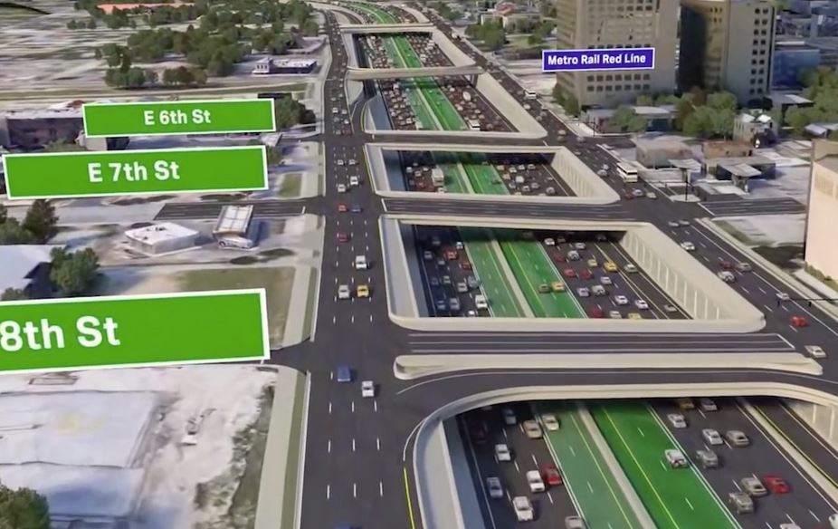
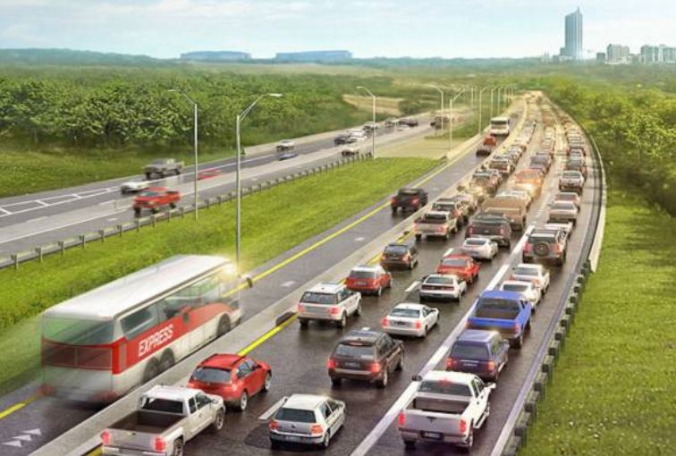
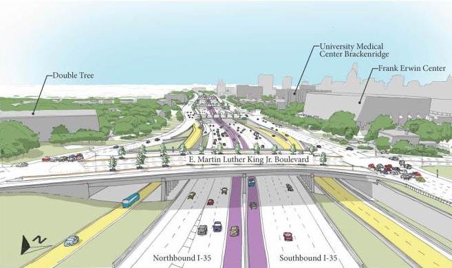
Rendering of rebuilt I-35 at MLK Blvd. with HOT lanes for use by “Super BRT” (shown in purple and yellow). Graphic: TxDOT.

The leadership of Austin’s Capital Metropolitan Transportation Authority (CMTA, aka Capital Metro) seems to be rolling forward full-throttle to implement a dubiously described “bus rapid transit” (BRT) plan for Interstate Highway 35 pushed by by the Texas Department of Transportation (TxDOT) to bolster the highway agency’s massive over-$4 billion I-35 upgrade project. This mammoth project was the focus of a March 2016 posting on this website by Roger Baker and Dave Dobbs headlined «Why spending $4.7 billion trying to improve I-35 is a waste of money» (with the secondary headline «Trying to widen Austin’s most congested road will only make congestion worse»).

As that article warned,

TxDOT is far short of sufficient funds to widen I-35 with its own resources, having identified only $300 million in-house out of $4.5 billion needed. That leaves TxDOT $4.2 billion short — over 90% deficient. In fact, the Travis County section of TxDOT’s My35 redesign is still $1.8 to $2.1 billion short, which should raise red flags for local property owners who could well be targeted for big tax increases.

During this period, Capital Metro resuscitated Project Connect – its major planning effort ostensibly tasked with evaluating possible rail and other forms of “high-capacity transit” – to supposedly sift through various corridors, types of service, and alternative transit modes, and develop recommendations for a package of major new “high-capacity transit” investments. The process has been performed nominally with the oversight of the Multimodal Community Advisory Committee (MCAC).

Mysterious new “Super BRT” project appears

For a while the Project Connect study appeared to stay mostly on track, still focused on corridors, and just starting an evaluation of transit modes. But then it seemingly began to take a detour this past summer, when reports began to reveal TxDOT’s sudden interest in obtaining Capital Metro’s commitment to a very specific transit decision: a mysterious new “bus rapid transit” project on I-35, proposed to use High-Occupancy Toll (HOT) lanes planned for the huge reconstruction of the freeway. (See graphic rendering above.) In a June 27th article Austin Monitor reporter Caleb Pritchard noted some details about the BRT plan discussed at a Capital Metro board meeting the previous evening, including TxDOT’s efforts to muscle the transit agency “to fork over $123.5 million to cover the entire cost of the [bus project] transit infrastructure.” At this, reported Pritchard, Capital Metro had “balked”, but was negotiating with TxDOT on a “counter-offer” to “cough up approximately $18 million” toward such a project and to seek other agencies (such as the City of Austin) as partners.

According to the article, Capital Metro’s vice president of strategic planning and development, Todd Hemingson, revealed that the transit agency had “been talking with TxDOT for five years about the I-35 bus rapid transit plan.”

The department is planning a $4 billion overhaul of the highway and appears to be open to the agency’s insistence that the project include some dedicated allowance for transit. The formative vision for the bus rapid transit system includes a handful of stations built on bus-only lanes in the median of the interstate. Those stations, Hemingson said, would be paired with frequent-service bus routes on intersecting east-west corridors.

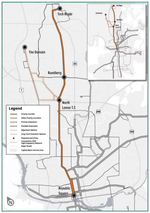
The initial ridership projects for the proposed route between Tech Ridge Boulevard in North Austin to State Highway 45 in South Austin is between 4,000 to 6,000 trips per day.

At the meeting, Multimodal Community Advisory Committee member Susan Somers (president of the AURA urban issues community group) “raised concerns about moves that appear to make a proposed bus rapid transit system on I-35 a predetermined outcome of the Project Connect process.”

TxDOT’s arm-twisting intensified. Within weeks, the highway agency was insisting that Capital Metro had better speed up and get with the BRT program to contribute its share to the big I-35 rebuild project. Pritchard captured the situation in a subsequent July 13th Austin Monitor report headlined: «TxDOT pressures Capital Metro to act fast on I-35 transit».

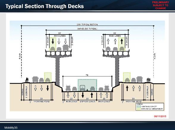
As Pritchard’s report elaborated, the BRT plan emerging from the shadows already had quite a bit of detail. TxDOT wanted money to cover the cost of right-of-way “for three bus rapid transit stations to be built in the middle of the highway.”

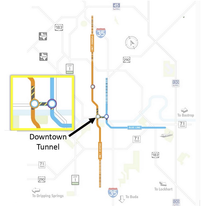
Those three stations would be near Tech Ridge Center, at Rundberg Lane and at Slaughter Lane. The bus line that would service those stations would operate in new express lanes that TxDOT is planning to add to the freeway. The stations would allow the buses to pull out of the travel lane to allow boarding and deboarding without interrupting traffic flow. The buses would also enter and exit the highway in downtown Austin, perhaps via dedicated transit ramps, and terminate in the south at a park-and-ride off State Highway 45 Southeast.

Capital Metro VP Hemingson had also revealed that the original plan for “BRT” had been even more extensive, but had to be scaled back because of funding limitations.

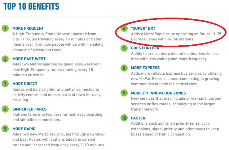
Hemingson told the board that his team originally proposed to TxDOT a “super bus rapid transit” model that would have included inline stations at 51st Street, Oltorf Street and William Cannon Drive, three roads whose intersections have seen recent infrastructure investments by the state agency.

“It was kind of met with a thud, that idea,” he reported, citing its estimated cost of $400 million, or 10 percent of the roughly $4 billion that TxDOT is planning to spend on the entire I-35 project.

TxDOT’s mounting pressure on Capital Metro was corroborated on July 24th by the Austin American-Statesman. In a news report with the headline «TxDOT: Cap Metro must pay to put buses on future I-35 toll lanes», the paper’s transportation reporter Ben Wear cited the $123 million cost for the “rapid bus stations” and noted that “The agency is pressing Capital Metro for $18 million now to buy land needed for those stations.” However, reported Wear, a “Cap Metro official says the full $123 million cost is beyond its means to pay in the coming years.”

But the benefits of that $123 million investment seemed to be steadily diminishing. An August 11th Austin Monitor news update by Caleb Pritchard aptly titled «TxDOT document reveals limp projections for I-35 bus plan» reported that TxDOT had “projected less than stellar ridership numbers” for the proposed “BRT” service – at most, 3,400 boardings a day. In ridership, that would place the “rapid transit” bus line ninth among the transit agency’s other routes, well behind an assortment of more ordinary and somewhat less spectacular street-based services without heavy investment.

This tends to reflect the major disadvantages of trying to install a viable, higher-quality transit operation within a freeway. Passenger access to and from the stations – especially pedestrian access – is a distinct problem. Transit-oriented development (TOD) – particularly residential development – ranges from poor to actively discouraged. Economic development goals are unfulfilled. Yet, because of the difficulties of construction and the high land values around a freeway or tollway, capital costs are inordinately extremely high.

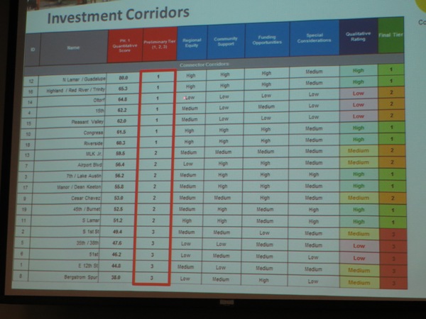
Yet abruptly, after months of a supposedly impartial, rigorous process of laboriously pursuing data-led solutions … Project Connect and its parent agency Capital Metro were suddenly abandoning that rigorously defined exercise, bypassing the whole process, and embracing a plan for an approximately 20-mile, $123.5-million, 3-station “BRT” line in I-35 that had actually been in Capital Metro’s planning process, albeit at a very low profile, for the past five years.

Curiously, our website (ARN) had already reported hints of such a pre-planned outcome last November. In an article titled «Capital Metro — Back to 1986?» we observed that “Austin’s Capital Metro seems determined to return to the thrilling days of yesteryear – at least in its longrange transit system planning.” A key basis for our suspicion consisted of reports from longtime Austin-area transportation activist Mike Dahmus, together with “with confirmation from other participants”, making it “clear” that “”some implementation of ‘bus rapid transit’ (BRT) on I-35 is (in the words of one observer) a ‘foregone conclusion’.” ARN had noted that this was a “revival” of a nearly identical but “faulty 1986 plan from the agency’s past.”

And additional evidence that a “BRT solution” has actually long been slated for implementation (despite an ostensible “study” process) has continued to emerge. A commentary by David Orr in ARN’s posting of Aug. 31st revealed that a Connections 2025 brochure disseminated by Capital Metro listed the I-35 “Super BRT” plan as if it were already approved as a project in line for implementation.

Minneapolis “Orange Line BRT” — a faulty model

Much of Capital Metro’s case for the I-35 “Super BRT’ plan appears to use a somewhat similar HOV-lane nominally “BRT” operation in Minneapolis as a model. Dubbed the Orange Line, the 17-mile express-bus-on-highway project is currently under development for the metro area’s I-35W corridor. However, the Minneapolis Metro Orange Line project is significantly different from what TxDOT and Austin’s Capital Metro and Project Connect are proposing. (Information regarding the Orange Line project has been obtained via discussion with former Metro planner Aaron Isaacs as well as online material from the Minneapolis Star-Tribune and Metropolitan Council.)

First, it would seem that the status of I-35 in Austin (with almost imperceptible bus service) is nothing remotely like Minneapolis’s 45-year-old, mature, heavily used I-35W transit corridor, with 25 bus routes, 14,000 daily rider-trips, and substantial existing transit investment, proposed for upgrading into the Orange Line (including one in-line station)
.
Minneapolis’s I-35W bus transit system dates from the early 1970s, when the administration of President Richard Nixon was encouraging investment in enhanced bus operations as an alternative to planning what it perceived as more expensive rail transit. In Minneapolis, this started with metered freeway ramps (controlling access to the freeway); beginning in 1972, HOV bypasses to the metered ramps were implemented, with more being added over the subsequent years. Metro also implemented bus-only shoulders on portions of I-35W and feeder highways 62 and 77.

Eventually this operation included HOV lanes (opened in 2009) used by buses. One “in-line” bus station is already in operation in the middle of I-35W.


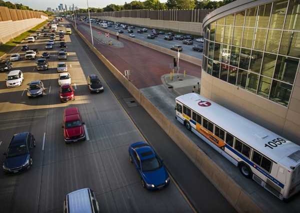
Minneapolis Metro express-bus operation (slated for upgrade to Orange Line) has a single station in median of I-35W. Photo: Metro.


This program never produced ridership and benefit results anything close to what would be expected of a major rapid transit (or light rail) investment – a drawback that became a major factor persuading Minneapolis decisionmakers to proceed with the Hiawatha Avenue light rail transit (LRT) project (now the Blue Line) which opened in 2004. This raises the question whether it is prudent for Austin to follow a similar course of heavy bus transit investment in the I-35 corridor as its major transit option.

Secondly, the Orange Line is not intended to be Minneapolis’s heaviest major transit corridor. That role is already performed by the region’s two LRT routes – the Blue Line with 31,000 daily ridership and the Green Line with 37,000.

Third, in addition to the already-established heavy infrastructure involved in the Orange Line project, it’s relevant to note all the additional infrastructure in terms of surface dedicated lanes that exists and is being expanded with this project. Downtown Minneapolis already has an entire bus mall. This infrastructure is essential to support the heavy volumes of buses the transit agency channels through downtown Minneapolis. (Fortunately, LRT absorbs a huge portion of the total transit volume and handles this more efficiently with trains.) Are the City of Austin and Capital Metro prepared to include this level of downtown infrastructure investment in the project package in addition to the proposed “super BRT” on I-35?

Finally, it’s important to realize that a “BRT” project nearly identical to what Project Connect is now proposing was proposed and rejected in the late 1980s, in favor of LRT on a somewhat parallel route (including Guadalupe-Lamar). The main reason: the high capital cost of inserting this heavy infrastructure into the narrow I-35 freeway corridor. The proposed high volume of buses (with traffic implications for the Core Area) was also a factor in the elimination of this alternative.

Fake “BRT”, “Super” or otherwise

As one takes a broader view of this entire issue, it is legitimate to question whether it is valid to consider buses running in HOV or HOT (high-occupancy toll) lanes as “bus rapid transit” (BRT) at all.

One of the key criteria specified for “true” BRT has been having a right-of-way or alignment clearly designated as exclusive for the bus-only operation. The basic argument behind this has been that to emulate rail systems, all of which have a defined trackway that passengers know identifies the rail line (especially surface LRT), the BRT operation must have a correspondingly uniquely identified alignment reserved for its exclusive use. This is important in order to (supposedly) impart a comparable sense to passengers and the general public of the presence of the route and where it goes – i.e., a crucial factor in orienting passengers and the general public to this service. An HOV tollway open to general mixed-use traffic does not provide this characteristic.

Furthermore, the TxDOT/CMTA proposal for I-35 “BRT” would have the “rapid transit” buses leave the freeway entirely to serve most stations off the “highspeed” facility. That certainly would seem to violate the concept of a readily understandable, visually clear “rapid transit” route. Not to mention putting a big dent in travel time.

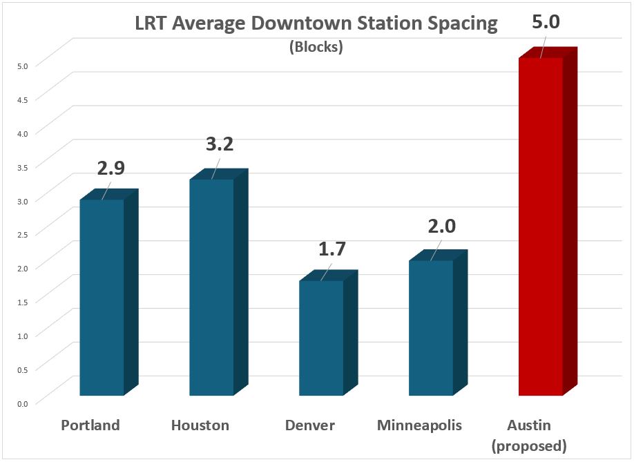
And some final considerations: With three proposed “inline” stations over about 20 miles, the I-35 “BRT” would have an average station spacing of about 10 miles. What “rapid transit” line in the world has station spacing averaging 10 miles? BART (which has some of the function of a commuter rail as well as rapid transit) has an averaging spacing of about 2.8 miles, and that’s unusually long. The next in line, the Washington Metro, averages 1.4 miles.

Our own conclusion: What’s being promoted as “BRT” – bus-style “rapid transit” – on Austin’s I-35 would be basically just a commuter bus operation, with some added amenities.

LRT makes more sense

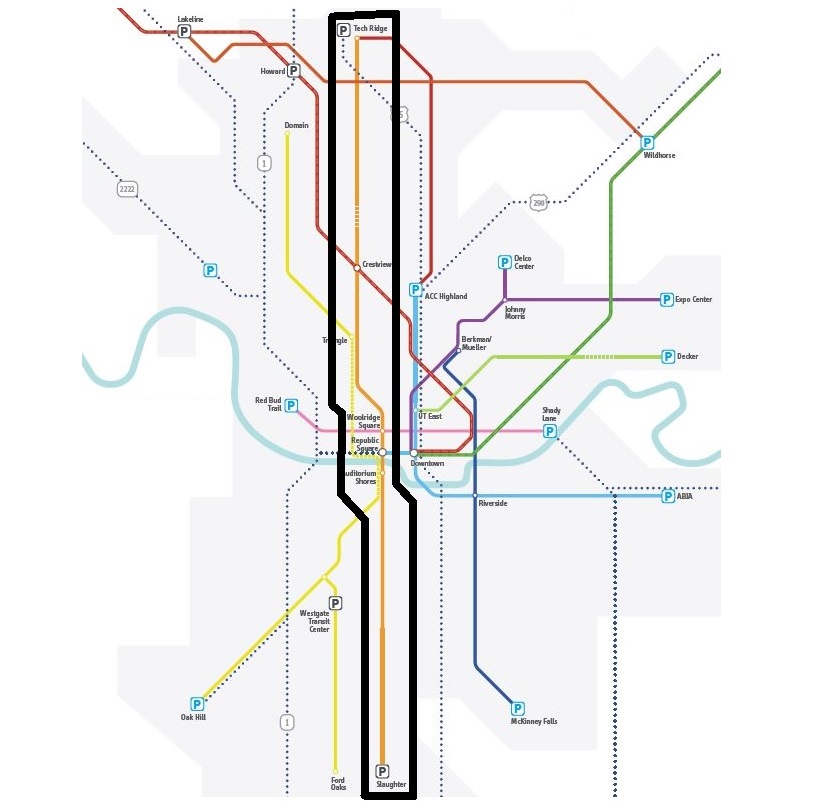
There’s a far more attractive, effective, workable, beneficial, and ultimately affordable public transport alternative to the TxDOT-Capital Metro-Project Connect express-bus plan packaged as “Super BRT”. This alternative is LRT – specifically, as ARN proposed in our July 31st article «Urban Rail on Guadalupe-Lamar, Not I-35 “BRT”» – a 21-mile LRT line paralleling I-35 but serving the center of Austin.

Running from Tech Ridge in the north to Southpark Meadows in the south, mainly via North Lamar, Guadalupe, and South Congress, such a line would offer dozens of stations and immensely greater accessibility, available mobility, attractiveness, ridership, and benefits to the community.


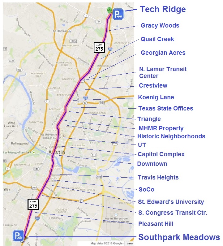
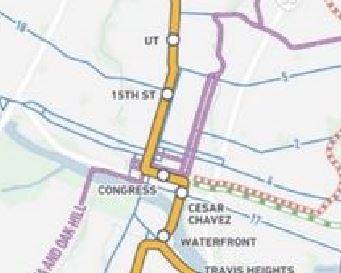
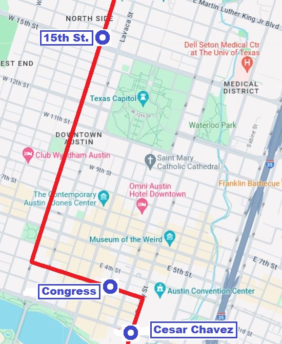
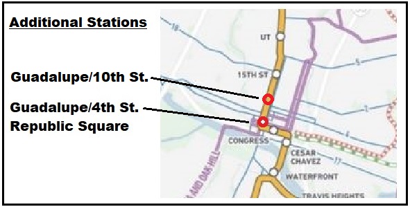
Proposed LRT running in Guadalupe-Lamar and South Congress corridors from Tech Ridge to Southpark Meadows, paralleling I-35. Graphic: ARN.


As our July 31st article indicated, the first segment should be a “starter line” in the Guadalupe-Lamar corridor:

Guadalupe-Lamar (G-L) is the center city’s 3rd-heaviest north-south corridor. In addition to major activity centers, the corridor serves a variety of dense, established neighborhoods, including the West Campus with the 3rd-highest population density in Texas. With Austin’s highest total employment density on Guadalupe-Lamar, an urban rail line could serve 31% of all Austin jobs.

An initial 6 or 7 mile LRT starter line from U.S. 183 or Crestview to downtown could serve as the initial spine of an eventual metrowide system, with branches north and south, northwest, northeast, east, southeast, west, and southwest.

This kind of investment in LRT would appear to represent a far greater value for money, with potential for a much higher ROI (return on investment), than even a lower-cost express-bus project such as that proposed by TxDOT and Capital Metro, and it surely deserves a fair and impartial evaluation through the legitimate Project Connect study process. The attempt to ram through a “rush to judgement” for TxDOT’s “Super BRT” plan (evidently aimed in part to obtain Capital Metro’s buy-in for the I-35 mega-project) deserves to be jettisoned.

h1

Officials boost roads and “Super BRT”, put urban rail on side track

31 August 2017

Cross-section of one version of TxDOT’s plan for massive rebuild and expansion of I-35. Center tolled “express” lanes (at bottom center of diagram) are proposed for use by “Super BRT” project to be funded and operated by Capital Metro. Graphic: Mobility35. (Click to enlarge.)

Commentary by David Orr

David Orr, an Austin community activist involved with transportation issues, is a longtime environmental justice and transportation advocate.

Last month, on July 26th, Capital Metro’s Project Connect, together with several other regional agencies, sponsored another of their “Traffic Jam” community meetings to discuss possible options in the planning process. This mainly consisted of a panel of professionals and officials, some local, and some from elsewhere in the country, sitting on a stage in a chapel at Huston-Tillotson University explaining different transit issues to the audience.

I attended this event, but was extremely disappointed in what I saw for a number of reasons. For one, the talking heads were allowed to go over their allotted time (typical for politicians and agency officials), leaving only a half-hour of the two and a half hours of the originally scheduled event time for audience participation. This common practice is designed to minimize public input and maximize officials’ output (i.e., a PR effort).


Project Connect-sponsored “Traffic Jam” meeting on July 26th at Huston-Tillotson University. Opportunity for audience participation was truncated. Photo: L. Henry.


More importantly to our concerns, as was the case with the April “Traffic Jam”, the politicians never got specific about mass transit and talked instead mostly about how expensive transit is and how little money they have. At the same time they have been touting how much good they’re doing building new road capacity with the 2016 bond issue.

Capital Metro’s blog post on the recent “Traffic Jam” added little of substance, but in truth there was little offered by the consultants and local officials, so not much to report on. This event could have been much more effective had there been discussion of Austin’s specific needs, rather than dwelling on reports of what worked in other cities. There was no mention from the stage of what kind of new transit should be built here – and where. That was a glaring omission in the program agenda. It seemed a clear message that they’re seeking public (written) comment of the kind where officials will not be required to respond with any specificity, much less take a stand for or against. I hope I’m wrong, but to date the only messages we’ve received indicating openness to specific forms of new transit initiatives relate to what they’re calling “Super BRT” as if it were a done deal.

The “Super BRT” idea has been brought to public attention only within the last couple of months, bypassing Project Connect’s ongoing “high-capacity transit” study. A June 27th article by Caleb Pritchard in the Austin Monitor cited information from Capital Metro’s vice president of strategic planning and development, Todd Hemingson:

… Hemingson told reporters that the agency has been talking with TxDOT for five years about the I-35 bus rapid transit plan. The department is planning a $4 billion overhaul of the highway and appears to be open to the agency’s insistence that the project include some dedicated allowance for transit. The formative vision for the bus rapid transit system includes a handful of stations built on bus-only lanes in the median of the interstate. Those stations, Hemingson said, would be paired with frequent-service bus routes on intersecting east-west corridors.

This “Super BRT” is really a “pseudo BRT” plan, since the buses would run with mixed traffic in HOV toll lanes (“HOT lanes”). Basically, it seems like just another express bus system with some added improvements.

At the July 26th “Traffic Jam” I was particularly disturbed by a glossy brochure being distributed from Capital Metro titled Connections 2025, which laid out in very concrete terms the agency’s “vision” for the next five years. Nowhere in this document was any rail expansion even mentioned as a possibility. In contrast, the I-35 “Super BRT” plan was mentioned twice, in both places identifying it as if it’s already approved as a project in line for implementation.


Capital Metro’s Connections 2025 brochure includes “Super BRT” as an assumed project. Graphic: CMTA. (Click to enlarge.)


There was no discussion at all of this “Super BRT” project on I-35 during any of the many presentations and speeches during the program, and the very abbreviated public Q&A at the meeting did not permit me to ask for clarification. The only mention in this document of the Guadalupe-Lamar corridor was the continued development and expansion of MetroRapid 801 as well as 803 and additional routes. If they intend to continue to dump cash on the “rapid bus” projects in this corridor, that would effectively preclude serious discussion of a light rail transit (LRT) project in that corridor within the next decade at least.

In the Connections 2025 brochure, the “Super BRT” project was listed on the agency timeline for completion by 2023. Needless to say, it looks like the fix is in, at least as far as Capital Metro is concerned. However, I did ask a Project Connect staffer whether this was now a foregone conclusion, and he insisted it’s not. He also said that LRT is still on the table, but admitted that no one at the agency is really discussing it. That was an eye-opener.

Clearly this is a major challenge to those of us – transit advocates and a large contingent of neighborhoods and other community members – who have been backing LRT in Guadalupe-Lamar (G-L). Perhaps It’s time to request Capital Metro’s board for clarification on their plans for “Super BRT” and how their public input supports this major investment. Especially in view of the fact that this carries a huge opportunity cost for alternatives that might include LRT anywhere else in the city, much less on the G-L route. It’s clear that Capital Metro has been intentionally avoiding responding to the continuing public input they’re receiving in support of LRT and the lack of public support for this “Super BRT” notion.

It may also be necessary at some point to bypass Capital Metro and take this directly to the City Council. Council can make this happen even if they have to drag the transit agency off the “Super BRT” express bus.

However, there are other factors in play that may take the air out of the tires of this scheme. A July 24th article by Ben Wear in the American-Statesman quotes a TxDOT spokesperson regarding the request for money from Capital Metro for in-line stations on I-35. The TxDOT representative insists that “as far as financing goes, none of our funding sources will cover transit.”

Based on my reading of this news report, it seems TxDOT has given Capital Metro a clear signal that “Super BRT” will only happen if the transit agency pays for it. In the current situation, that’s actually very good news from the standpoint of proper planning and what kind of major transit improvement Austin truly needs – LRT.

If Capital Metro can’t raise the funds on its own to build this “Super BRT” – or even some scaled-back version of it – that will likely be the end of that bad dream. Presumably its proponents would have to get some bond money to fund it, but if that had to go before the voters it could turn out like the Prop 1 debacle which failed because the public support just wasn’t there. Capital Metro’s credibility would be pretty much destroyed. So maybe there is hope for a G-L LRT after all. From a politics standpoint, it’s usually easier to kill something controversial than it is to approve it.

A small but vocal opposition armed with facts could probably sink “Super BRT” if it came to a bond election. I suspect that politically aware members of Capital Metro’s board would be sensitive to sustained expressions of support for G-L LRT, and if there’s no evident support for Super BRT they may respond accordingly, if reluctantly.

We have every reason to doubt that Capital Metro will even be able to come close to providing the money demanded by TxDOT to build the “Super BRT” line, at least to whatever standards Capital Metro may determine will have a ghost of a chance in reaching reasonable ridership numbers. This would be a situation where the lack of agency funding could actually work to the benefit of truly effective transit – i.e., an urban rail alternative.

In any case, approval of G-L LRT will itself require a public vote. Nevertheless, supporters of this long-overdue project have good reason to believe it will pass if we can bring strong public support to the cause. We’ll have to win an election, and we need to start strategizing now.

My hunch is that funding “Super BRT” will kill off LRT for the next decade. Conversely LRT could do in this pseudo-BRT project. It’s a zero-sum game. So long as BRT is getting all the official attention our side is side-lined in the public’s eyes.

It’s been pointed out here that the likelihood of funding I-35 “Super BRT” through a public bond vote would be much less likely than is the case with LRT, which would run where people actually live and work. One of our most potent arguments is that high ridership depends on convenience and flexibility in options for future build-out/expansion. Yet “Super BRT” on I-35 is just a one-trick route, with few options for east-west routes. In contrast, LRT of course has many possibilities for eventual expansion.


Rendition of LRT on Drag from 2000. Graphic: Capital Metro, via Light Rail Now.

Rendition of LRT passing UT campus on Guadalupe St. An initial starter line in Guadalupe-Lamar corridor would provide basic urban rail backbone for expansion into a citywide system. Graphic: Capital Metro, via Light Rail Now.


This is the sort of discussion that Capital Metro should be facilitating as part of the Project Connect planning process. One bright spot I have seen recently in the process is the agency’s stated intention to respond on their website to written comments. This is an opportunity to find out how responsive the agency is to public interest and demands for specific proposals. At least Capital Metro has not so far ruled out anything.

Thus it is up to pro-rail transit advocates to submit written comments. It’s critical that the written public record reflect the breadth and depth of support for options on the table for consideration. Strong and persistent demonstrations of support for a G-L LRT starter line project may persuade Capital Metro to rethink some of their assumptions and give supporters of this plan a fair hearing, and a detailed response.

This would also be helpful in familiarizing more Austinites with the G-L LRT plan and the case that can be made on its behalf. Advocates of LRT – including the starter line LRT project in the Guadalupe-Lamar corridor – have sufficient expertise and numbers behind this proposal to present a credible and persuasive concept that will be difficult to dismiss.

So long as positive expressions of support are received the transit agency must recognize the breadth and depth of support for urban rail. Hopefully some official heads can be persuaded.

h1

Reorganized Project Connect 2.0 opens up, reaches out

30 April 2017

Guadalupe-Lamar corridor places at top of Project Connect’s table of corridor rankings shown in slide at April 26th MCAC meeting. Photo: L. Henry. (Click to enlarge.)

Has Austin’s public transportation planning and decisionmaking establishment turned a new leaf?

That’s yet to be fully determined. But … if Project Connect – the Capital Metro-sponsored major planning effort in charge of evaluating possible rail and other forms of “high-capacity transit” – offers any indication … there may be signs of a changed focus.

The original Project Connect earned intense distrust from Austin’s most ardent transit advocates because of its role leading the 2013-2014 High-Capacity Transit study that produced the disastrously flawed $600 million Highland-Riverside urban rail proposal (defeated by voters in November 2014). In contrast, the current planning agency (“Project Connect 2.0”) appears to have actually undergone a makeover in some important respects.

Personnel — A totally new planning team, with completely different personnel from the original Project Connect.

Consultants — A new consultant team led by AECOM.

Methodology — A focus on actual travel corridors rather than the original Project Connect study’s method of slicing up central Austin into districts and sectors and mislabeling them “corridors” and “subcorridors” … plus analytics that seem more accurate in evaluating and prioritizing corridors for a comprehensive plan.

Public involvement — What seems to be a much more sincere effort than in the past to solicit and engage actual involvement by key members of the community in the nuts and bolts of the planning process.

Included in this outreach have been strong advocates of urban rail for the Guadalupe-Lamar corridor. Invited to an April 17th consultory meeting, representatives of the Texas Association for Public Transportation (TAPT, sponsor of the Light Rail Now Project and this website) and the Central Austin Community Development Corporation (CACDC) were presented an overview of Project Connect’s planning process and its current status, which appeared to represent a new direction in goals and methodology and a somewhat new approach to public involvement.

Currently Project Connect is completing what it designates as Phase 1 of its overall analysis – concentrating mainly on evaluating and selecting corridors as candidates for possible “high-capacity transit”. Phase 2, according to the agency, about to begin, will focus on selecting modes (i.e., types of “vehicle” systems), identifying funding mechanisms, determining “the best set of solutions”, and recommending Locally Preferred Alternatives (LPAs).

At the April 17th meeting, the attendees were told that the Guadalupe-Lamar corridor was ranking quite high in the evaluation. They were encouraged to attend a public meeting of the Multimodal Community Advisory Committee (MCAC), set for April 26th, where the major results of Phase 1 would be presented.

And indeed, at the April 26th MCAC meeting, Project Connect team members, via a slide presentation led by the project’s Director of Long Range Planning Javier Argüello, revealed the study’s conclusion: Guadalupe-Lamar had emerged as the study’s top-ranked corridor. (At top of this post, see closeup of slide of ranking table.)


Project Connect’s table of corridor rankings shown in slide at April 26th MCAC meeting. Photo: L. Henry. (Click to enlarge.)


From here, according to the study timetable, the focus will narrow on possible modes (rail modes, buses, others) and comparative costs. Obviously, there’s no guarantee that light rail transit (LRT) on Guadalupe-Lamar – the center of substantial community interest for decades – will make the final cut.

Unfortunately, it’s possible that an evaluation could be impaired or skewed by false assumptions. For example: Buses in dedicated lanes may rate as a “high-capacity” mode, but they have not shown that they can attract passengers to utilize that capacity at a rate or level comparable to LRT. Also, LRT has shown a much higher propensity to attract adjacent development – particularly transit-oriented development, or TOD – than “high-capacity” bus services such as MetroRapid. And there are other significant performance and operational issues to consider.*

*See:
New light rail projects in study beat BRT
LRT or BRT? It depends on the potential of the corridor

Nevertheless, despite an array of critical differences, study methodologies and planning models frequently treat rail and bus modes as if they’re totally interchangeable in key features such as attracting ridership, accommodating future ridership growth, and stimulating economic development.

So will an adequate, fair, accurate comparison be conducted? Are local public transport planners actually starting to move in a new direction? The jury’s still out. But Austin’s staunchest transit advocates are watching … and hoping.

h1

“Traffic Jam” to discuss “high capacity transit” becomes “bait & switch” push for road plans

26 March 2017

Graphic: Neonlink.com

By David Orr

David Orr, an Austin community activist involved with transportation issues, is a longtime environmental justice and transportation advocate.

Last year, during Austin’s prolonged community debate over the $720 million mainly roads-focused “Go Big” bond measure, supporters of an urban rail starer line in the Guadalupe-Lamar corridor rallied behind a plan put forward by the Central Austin Community Development Corporation (CACDC). Unfortunately, Mayor Steve Adler (together with several city council members) insisted that the community wasn’t “ready” for such a plan – so a rail vote would have to wait. Many in the community are now wondering: Is there a current initiative to get rail back on the ballot?

Judging from recent events and statements by leading public officials, leadership for rail continues to appear close to nonexistent.

Take for example, the “workshop” at the Bullock Museum on Saturday March 4th sponsored by the reincarnated Project Connect and billed as a “Traffic Jam”. Supposedly a kickoff for a new planning process for “high capacity transit” systems, this event (which turned out to be a sort of “bait & switch” escapade) featured a panel consisting of Mayor Adler, Senator Kirk Watson, Rep. Celia Israel, Capital Metro Board chairman Wade Cooper, and CAMPO (Capital Area Metropolitan Planning Organization) Executive Committee member Terry Mitchell.

At no time was “high capacity transit” even mentioned, let alone covered in any substantive way. The happy talk was all about how hard they worked at the legislature and all the compromises they gladly made only to see their efforts come to naught. The only specific comment Rep. Israel made was that we shouldn’t let the “perfect be the enemy of the good”, presumably by pushing high capacity transit, and that “tires” were what sells to local governments. As opposed to … rails?

Watson & Co. were all smiles about the more than $700 million allocated for facilities for cars – but no mention of funding for transit at all, except that it would be very difficult to get and it would be sought only at some point in the future.

Traffic Jam, indeed.


Promotional notice for “Traffic Jam” event at Bullock Museum, 4 March 2017.


Given this latest iteration of Project Connect, especially as revealed in this recent workshop at the Bullock Museum, I’d say that a rail ballot issue is farthest from the minds of Steve Adler as well as Celia Israel and Kirk Watson, all of whom spoke at some length on the virtues of more “tires” (as Israel put it)​ and of their pride and excitement at moving forward with road building following the bond passage last November.

Never mind that this meeting was supposed to be about planning for “high capacity transit” – there was near-ZERO discussion by these elected officials of any desire for, much less commitment to, building up Capital Metro infrastructure. Also on the stage, as noted above, were members of CapMetro’s board and of CAMPO’s board. The closest any of them came to discussing “high capacity transit” was to bemoan the lack of funding, as if to pre-empt any further talk of building high capacity transit – unless “you” (apparently meaning we the people in the audience and/or those in the general public at large who care about the matter) can find the big bucks required to do anything.

The only mention of expanding CapMetro service was Rep. Israel’s expressed desire to expand into Pflugerville, but this was in the context of her expressing that city’s desire to see service in their city. Her comment about “tires” was made in response to a point she was making about satisfying the demands of Pflugerville city council for action to implement fixed-route service. There were vague references to expanding farther, but they carefully avoided mentioning any other currently unserved/underserved outlying cities or counties, involving either urban or rural areas.

The only mention of actual plans for improved service was their agreement with CTRMA (Central Texas Regional Mobility Authority, primarily a tollroad development agency) for allowing buses to use the high-occupancy/tolled “Lexus lanes” on Mopac (i.e., Loop 1, as well as perhaps on the TBA expanded I-35). Speakers touted their hard-bargaining negotiation with CTRMA, carefully couched in terms that made CTRMA look magnanimous rather than cold-hearted.

So to answer directly that question from the first paragraph, as posed by many in the community: I have huge skepticism whether Mayor Adler would ever commit to supporting rail. “BRT” perhaps, but I’d be surprised by even that.