Archive for the ‘Austin transportation planning’ Category

h1

Transit planning cabal-style

28 February 2017
Graphic: Marvel Database.

Graphic: Marvel Database.

In recent weeks, within Austin’s transit advocacy community, rumors have been circulating of some kind of “package” of major transit projects possibly being compiled, perhaps for the November 2018 election cycle. While details are murky – concocted behind the veil of a resuscitated Project Connect and the tightly shuttered enclaves of the high-level leadership consortium of Capital Metro, City of Austin, plus some Travis County and state officials – it is whispered that such a plan might include a “Guadalupe-Lamar project” as well as an expansion of the MetroRail regional railway, a highway-routed bus “rapid transit” (BRT) line, and other possible projects.

A “Guadalupe-Lamar project” sounds great – a starter light rail transit (LRT) line in the Guadalupe-Lamar (G-L) corridor would represent the crucial linchpin of an eventual LRT (urban rail) network for the entire metro area. But there’s no guarantee that LRT is the “project” behind the dark curtain. Whatever concrete details of these wisps of plans may exist seem to be closely guarded secrets. For the G-L corridor, officials, planners, and their consultants may be envisioning urban rail, or they might just as plausibly be concocting more investment in the pathetic MetroRapid faux-“BRT” operation … or a cable-gondola line … or some other scheme.

The problem is that this top-level methodology of secrecy is now the routine modus operandi of most of Austin’s major public transport planning. And this, in an era of so-called “transparency”.

In fact, a lot of this methodology comes close to the definition of a cabal: “the contrived schemes of a group of persons secretly united in a plot ….” While it doesn’t have the cohesiveness of a bona fide cabal – and it certainly isn’t motivated by evil intent – today’s transport planning process nevertheless feels enough like a behind-the-scenes cabal to merit this unfortunate comparison. (And that’s why we’ve dubbed it “cabal-style”.)

Local planning wasn’t always this Machiavellian. Back in the early days of the Austin Transportation Study (predecessor of CAMPO) and Capital Metro, particularly in the 1970s and 1980s, planning was upfront; plans were on the table for public review, discussion, and debate. Community activists were intimately involved in the planning process; public participation was vigorous and vibrant. Meetings of advisory bodies such as Capital Metro’s Citizens Advisory Committee and Transitway Corridor Analysis Project Advisory Committee were frequent and well-attended, often by participants in the dozens. Plan proposals were not only clearly on view, but were shaped and fine-tuned by direct community input.

That process has, in recent years, been squelched. Interactive public meetings have been replaced by “open houses” and “workshops” where actual full discussion among all participants is excluded. Austin Rail Now has analyzed and criticized this deleterious process in considerable detail – see the numerous articles collected in the category Public involvement process.

Bona fide, free-speaking, freely attended, full public meetings are a critical component of democratic process. That’s how ideas are raised, shaped, tweaked, finalized – via discussion within groups of participants with a diversity of expertise, backgrounds, viewpoints, insights.

You can be sure that these occult, mysterious transit plans we’ve been referring to have been hatched by vigorous interactive meetings … not of the public, but of a relatively tiny, cabal-like huddle of officials, planners, and consultants sheltered from public view and involvement. A carefully assembled community body like the Multimodal Community Advisory Committee is allowed an occasional glimpse of what’s already been decided elsewhere … and then, only every few months or so. Back in the days of the directly involved and intensely active public advisory committees, meetings were held several times a month (especially in the final stages of formulating plans).

Even through this dark, distorted process, perhaps acceptable plans will emerge that will be embraced by the Austin community. But don’t hold your breath. The absence of direct, intimate, ongoing, adequately engaged, fully democratic public participation seriously increases the risk of flawed outcomes and political problems.

h1

Austin’s shaky economic growth presents challenge to “strategic mobility plan” remake

31 January 2017
Austin Strategic Mobility Plan (title slide from official presentation)

Austin Strategic Mobility Plan (title slide from official presentation)

By Roger Baker

Roger Baker is a longtime Austin transportation, energy, and urban issues researcher and community activist. The following commentary has been adapted and slightly edited from his comments recently posted by E-mail to multiple recipients.

Once more, Austin officials are floating the idea of producing another “Austin Strategic Mobility Plan”. As a Jan. 30th article titled «Economic forecast puts focus on transit, housing, jobs for 2017» reports, this effort is being resurrected by Austin Mayor Steve Adler: “Adler said City Council will work this year on a ‘regional strategic mobility plan’ that will eventually lead to an ambitious region-wide transit plan that could include rail”

Austin’s previous most ambitious effort at a Strategic Mobility Plan was soundly defeated in the Nov. 2014 bond package, but few know that.

One problem that Mayor Adler now faces, as a real estate lawyer dedicated to promoting maximum Austin and regional growth as policy, is a sharp decline in our regional economic growth due to the related factors of gentrification, decreasing mobility, and a correspondingly sharp decline in venture capital startups, since it locally peaked in early 2015.

Low job growth is bound to be a big story this year. According to a Jan. 5th report from the Dallas Federal Reserve Bank, we now see an annual job growth rate of only 0.6% in the whole Austin region, according to the most recent Dallas Fed data. As the bank states in its report,

Austin jobs grew 0.6 percent annualized over the three months through November. Jobs in goods-producing sectors saw sharp decreases as manufacturing and construction have continued to shed jobs since the summer. Retail trade jobs continued to decline moderately, while wholesale trade fell sharply.

Austin faces another unique state economic problem due to lower state sales tax revenue needed to fund state workers, as compared to the previous biennial state budgets. A 2.9% revenue decline doesn’t sound like a lot until you add in two years of inflation.

A stagnant state budget and decline in tech job creation, too, put a big burden on the tourism sector to maintain the Austin economy. It seems to me that the Hotel Occupancy Tax increase is being primarily driven by hotels that want to expand the Convention Center again. They probably represent more than a billion dollars of local private hotel investments, so they have a lot of skin in the game.

A lot of total current US growth is now happening because of high-technology-related job creation. Depending on high tech job growth is a risky industrial policy because this sector is especially prone to booms and busts, as the 2001 Dotcom bubble showed in the Austin area. There is a lot of national tech job competition involved. Even Nashville is seriously competing with Austin for venture capital startups, a category of speculative asset bubbles that have been stimulated by nearly a decade of the Fed’s near-zero interest rates. Cheap money encourages risk.

Tech growth can often pay high wages, but over time it leads to gentrification and transportation problems. That is because major highways like Austin’s I-35 fill up with traffic comprised of lower-pay service workers trying to commute out to the cheaper suburbs to live affordably. Austin residents could use good rail and bus transit inside the city. More difficult is the fact that providing high-quality transit service is not very compatible with the doubling Austin MSA (metro area) population, and the low-density suburban development being planned by CAMPO.

These problems associated with a booming tech industry are discussed in a Jan. 26th Washington Post article:

https://www.washingtonpost.com/realestate/fast-growing-technology-sector-is-fueling-a-housing-boom-in-cities-across-america/2017/01/26/5c72c276-a5d8-11e6-8042-f4d111c862d1_story.html

As the WaPo article reports,

Silicon Valley isn’t the only place a tech boom is fueling rising home prices. From Nashville to Raleigh, N.C., Austin to Cambridge, Mass., thousands of high-paying technology jobs are lifting home prices and fueling a boom in construction…

Dwindling housing supply and an affordable housing crunch are perhaps the biggest challenges in many markets seeing rising tech growth.

Also relevant is a Jan. 28th article in Austin’s Community Impact paper, which reports that …

… if Adler had it his way, those using public transportation in the future will be heading to new jobs. “Our neighbors, fellow Austinites, need mid-income jobs,” said Adler. “We know who needs the jobs in our community. We know the kinds of jobs that employers most need to fill. Which, by the way are information technology, healthcare and skilled trades.”

Adler’s goal over the next five years will be to move 10,000 Austin residents out of poverty by getting them qualified for jobs in those targeted industries. “If we’re going to focus our efforts at bringing the right jobs to town, we need to do more to make sure people who live here and need these jobs are qualified to take them. That’s where the Community Workforce Master Plan comes in.”

One important thing to focus on now is CAMPO, because they have formal control of the regional state and federal money, and because they had planned extreme suburban sprawl in the CAMPO 2040 Plan, bankrolled by a hypothetical $35 billion in future funds, envisioned for Lone Star Rail, and from other sources.

CAMPO is now doing their new 2045 plan. But our regional growth is slowing, because of side effects of prolonged growth discussed above, led by real estate interests attracted to fast regional growth. The new CAMPO 2045 regional population growth distribution will help reveal the political picture. Lone Star rail was taken out, so how can they handle the numbers of commuters they anticipate from the tech job growth that they anticipate along the I-35 corridor to San Antonio?

It is getting hard to maintain that there will be as much money as CAMPO had claimed last time. I think it is impossible to predict toll road revenues decades in the future, as TxDOT and the CTRMA claim to be able to hire consultants to do. It is likely necessary to use bond money to widen I-35, so they find private consultants with proprietary travel demand models that we are not allowed to see or to question. The public can’t see the CAMPO models, either.

TxDOT is still $23 billion in debt, because Texas politicians haven’t raised the gas tax for a quarter-century, and neither has Congress. Denial has its limits – and that should make this year very interesting. ■

h1

City’s “Smart Corridor” Prop. 1 bond plan promising way more than it can deliver

29 September 2016
Graph shows disparity between funds budgeted in "Smart Corridors" bond package and projected actual cost of these projects. (Graph: ARN.)

Graph shows disparity between funds budgeted in “Smart Corridors” bond package and projected actual cost of these projects. (Graph: ARN.)

In past postings we’ve roundly criticized the City of Austin’s “Mobility Bond” plan as a “non-mobility” proposal – there’s no transit project, and two-thirds of the funds are allocated for makeovers (“smart corridors”) of existing arterials. (With $101 million of “Regional Mobility” projects – highways and other major roads in the region – plus $26 million of other street and road improvements, the total allocation for roads comes to $609 million, or about 85% of the total $720 million “Mobility Bond” package.)

Now, according to a Sep. 25th exposé by Austin American Statesman transportation reporter Ben Wear, the bond proposal (now designated Proposition 1) falls appalling short of even fulfilling the “Smart Corridors” projects that it’s promising to voters.
http://www.mystatesman.com/news/news/local/wear-austins-go-big-road-bond-not-big-enough-to-co/nsdkh/

The “Highlights” to Wear’s article pretty much say it all:

• The $720 million bond proposition’s greatest vulnerability is that it promises much more than it can deliver.

• The bond includes $482 million for corridor projects estimated to cost more than $1.56 billion.

As Wear elaborates:

The Austin City Council, when it passed an ordinance in August calling a $720 million bond election, was pretty specific about how $482 million of that money will be spent.

That slice of the money, the five-page law says, will pay for “implementation of corridor plans” for nine, or perhaps eight of nine, specific city streets: North and South Lamar, Burnet Road, Airport Boulevard, Martin Luther King Jr. Boulevard, East Riverside Drive, Guadalupe Street, William Cannon Drive “and/or” Slaughter Lane. It doesn’t say “partial implementation” or “implementation of some of the following roads.”

So a voter could be forgiven for thinking that $482 million will do it all.

It won’t.

Not even close.

While just $482 million has been budgeted, reports Wear, according to staff estimates, “The total tab for the seven corridors that have a completed or in-progress study … would be $1.56 billion ….” He concludes:

You get the picture: The corridor money will pay for something between a quarter and a third of what the studies are recommending. But which quarter or third? Which corridors? What type of changes?

In other words, voters would be “buying” a “pig in a poke” … only that’s not what they’ve been told.

In the assessment of longtime community transportation activist and researcher Roger Baker (who has contributed several articles to this site),

This makes it pretty clear that Adler’s bond package is essentially top-down, business as usual road politics. This as opposed to a cost-effective engineering solution to some well-defined transportation problem or approach. Austin can’t possibly pave its way out of congestion by raising property taxes, and a truly smart city wouldn’t try.

Curiously, a group (seemingly anonymous) has been posting large signs around the city opposing Proposition 1 and denouncing it as “deceptive” as well as “destructive”. Given the shenanigans that Ben Wear has revealed, this kind of sentiment may spread. ■

h1

Guadalupe-Lamar urban rail needs to be included in Austin’s “mobility” bond package

27 July 2016
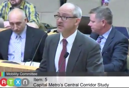
Ann Kitchen chairs City of Austin Mobility Committee meeting of June 14th. Photo: Sceenshot from ATXN video.

Ann Kitchen chairs City of Austin Mobility Committee meeting of June 14th. Photo: Sceenshot from ATXN video.

By Lyndon Henry

The following comments were made during Citizen Communications to a public meeting of the City of Austin’s Mobility Committee on 14 June 2016. Lyndon Henry is a transportsation planning consultant, a former board member of Capital Metro, a technical consultant to the Light Rail Now Project, and a contributing editor to this website.

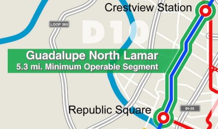
I urge you to include a measure for urban rail in the proposed $720 million “mobility” bond package now under consideration. I support the proposal for an affordable 5.3-mile light rail Minimum Operable Segment on North Lamar and Guadalupe from Crestview to downtown.

Currently 83% of the proposed $720 million package is devoted to road projects. Surely some of these road projects could be replaced with the $260 million to $400 million that would facilitate an urban rail project.


5.3-mile Minimum Operable Segment light rail line proposed by CACDC. Graphic: Screenshot from CACDC map.

Proposed 5.3-mile light rail transit starter line Minimum Operable Segment in Guadaluoe-Lamar corridor. Graphic: CACDC.


It’s absurd that the $720 million bond package you’re considering could be labeled a “mobility” package despite NO major initiative for transit, let alone urban rail, which has been studied and affirmed as a necessity for decades. This bond proposal stands in contradiction to the decades of official “green” rhetoric and policy initiatives such as Envision Central Texas and Imagine Austin that have verbally embraced public transportation and “high-capacity transit” as key “alternative mobility” measures necessary to “keep Austin moving”.

This road-focused $720 million package tries to address congestion by increasing “throughput” of vehicles. Unfortunately, experience and evidence suggest that this is a losing approach — trying to tweak more capacity to squeeze through more cars typically just induces more traffic. Furthermore, this influx of ever-growing vehicle traffic imposes more stress on congested areas such as Austin’s core.


Lyndon Henry presenting comments to City of Austin Mobility Committee on June 14th. Photo: Screenshot from ATXN video.

Lyndon Henry presenting comments to City of Austin Mobility Committee on June 14th. Photo: Screenshot from ATXN video.


In contrast, this light rail plan (and future expansions throughout Austin) removes traffic from roadways by attracting motorists to the transit service, adding the equivalent of four lanes of extra peak capacity to this corridor. Can the same be said for the current $720 million road-focused bond plan?

I suggest that urban rail — providing highly attractive rail transit service on its own dedicated tracks — makes far more sense as a solution for alleviating mobility congestion, than simply trying to squeeze more traffic onto the city’s crowded streets, roads, and parking spaces.

I’ve heard the argument that urban rail is “not ready” to be offered as a bond measure. Yet polls and other evidence indicate resounding support for public transit and urban rail, and the Austin community has gone through years of repeated outreach exercises familiarizing them with the technology and the issues. The public seems more ready than ever to support rail; it’s Austin’s civic leadership that seems to have cold feet.

Finally, whatever bond package you choose, I urge you to unbundle the roads bonds from the small proportion of bicycle and pedestrian bonds. This would allow the community at least to consider these alternative mobility elements separately. ■

[

NOTE: As of this posting, the Mobility Committee and City Council have approved the $720 million roads-dominated bond measure, without provision for transit, as a bundled package.
h1

Why spending $4.7 billion trying to improve I-35 is a waste of money

29 March 2016

Trying to widen Austin’s most congested road will only make congestion worse
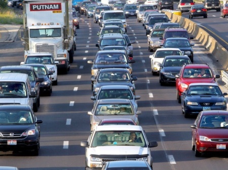

I-35 traffic congestion — bad and predicted to get much worse. Source: Culturemap.com.

Austin’s I-35 traffic congestion — bad and predicted to get much worse. Photo: Culturemap.com.


By Roger Baker and Dave Dobbs

The purpose of this analysis is to document the strong case against widening roads like I-35 (Interstate Highway 35, aka IH-35) to relieve congestion, especially when there are much smarter ways to use the same public money to solve transportation problems. This concept is important to understand because TxDOT (Texas Department of Transportation) is now actively planning to increase the lane-miles and vehicle capacity of I-35 along the San Marcos to Georgetown stretch of I-35 at a cost of $4.7 billion. This road section is ranked as the most congested corridor in Texas.

There is now a near-consensus by transportation experts that trying to relieve congestion by building and widening roads in very congested cities, like Austin, will actually worsen congestion. Severe congestion throughout a city during peak hour means that traffic will seek out and fill up any new freeway capacity as fast as it can be added. As discussed in a report by the U.S. Public Interest Research Group (USPIRG), the Katy Freeway in Houston, I-10 demonstrates this fact.

In Texas, for example, a $2.8 billion project widened Houston’s Katy Freeway to 26 lanes, making it the widest freeway in the world. But commutes got longer after its 2012 opening: By 2014 morning commuters were spending 30 percent more time in their cars, and afternoon commuters 55 percent more time.

In fact, it has been known for some time that building and widening roads doesn’t relieve congestion, but with urbanization, economic prosperity, and easy-guaranteed credit reinforced by automobile-centric federal transportation policy, the familiar American car-based suburban sprawl land pattern happens automatically. Rings of suburbs ever further from a city’s core inevitably lead to severe traffic congestion in every major USA city, Austin being no exception.

For decades, the Texas Transportation Institute (TTI) at Texas A&M University has effectively functioned as a pro-road think tank friendly to TxDOT and the Texas road beneficiaries. Understandably, until recently, TTI has been reluctant to admit that building more roads didn’t actually relieve congestion, which is a counter-intuitive outlook. However, using TTI’s own data, the reform-minded Surface Transportation Policy Project (STPP) was able to document this situation back in 1998:

By analyzing TTI’s data for 70 metro areas over 15 years, STPP determined that metro areas that invested heavily in road capacity expansion fared no better in easing congestion than metro areas that did not. Trends in congestion show that areas that exhibited greater growth in lane capacity spent roughly $22 billion more on road construction than those that didn’t, yet ended up with slightly higher congestion costs per person, wasted fuel, and travel delay. The STPP study shows that on average the cost to relieve the congestion reported by TTI just by building roads could be thousands of dollars per family per year. The metro area with the highest estimated road building cost was Nashville, Tennessee with a price tag of $3,243 per family per year, followed by Austin, Orlando, and Indianapolis.


TTI Roadway Congestion Index (Mean) shows that roadway congestion has continued to rise despite intensive investment in capacity expansion. Source: STPP.

TTI Roadway Congestion Index (Mean) shows that roadway congestion has continued to rise despite intensive investment in capacity expansion. Graph: STPP.


David Dilworth, in a 2012 posting, did the following review of the basic reasons why you can’t pave your way out of congestion, and what happens when you attempt it anyway.

1) There is now overwhelming evidence, including a nationwide study of 70 metropolitan areas over 15 years (Texas Transportation Institute), and another California specific study (Hansen 1995, which included Monterey County) that when an area is congested – additional lanes or roads do not provide congestion relief.
2) It is also well documented that additional lanes increase traffic, and that new highways create demand for travel and expansion by their very existence.
3) Further experience shows “When road capacity shrinks — So Can Traffic”; traffic congestion goes down!

So, when a road is congested, adding more lanes or roads will not relieve congestion, but will likely increase traffic.
When a road is congested the only way to relieve congestion is not by building more roads, but by reducing land use – or paradoxically by closing roads.

Closing roads and reducing land use clearly implies that planners will need to rethink mobility, i.e., moving people rather than cars, and finding ways to reduce travel distances so that walking, biking, and transit become the preferred alternatives.

Nowadays, even TTI has admitted that I-35 can’t be fixed in any meaningful sense. True, some lane capacity can be added, and an urban-friendly design could mitigate its impact on the center city. However, nothing will significantly address congestion as the following excerpts taken from a recent TTI report indicate.

…This modeling research demonstrates that Central Texas cannot “build its way out of congestion” on IH 35. Examination of the initial set of scenarios demonstrates that, as capacity is added to IH 35, traffic moves to IH 35 from other streets and roads that operate with even worse congestion, in essence “re-filling” the road. As described above, Central Texas drivers fill any capacity added to IH 35. Therefore, additional capacity provides little relief to peak-hour IH 35 general purpose lane congestion. And, because population and jobs are projected to grow so much in the corridor, any open road space created by new lanes is quickly filled. …

The study team concluded that this effort demonstrates a very unlikely future. That is, the levels of congestion predicted for IH 35 — in fact, the Central Texas region — will be unacceptable for local residents and business. In discussions with the MIP Working Group regarding these technical results, there is heightened concern that the levels of congestion demonstrated by this study would dampen the area’s growth in population and employment because people and businesses will quite simply not move here if the transportation infrastructure is insufficient to avoid this level of congestion. Therefore, with impacts predicted to be this substantial to quality of life and economic health, such levels of congestion will likely be unacceptable to future residents and businesses, so that the area’s growth is in fact, unsustainable….


I-35 congestion, considered worst in Texas. Texas Transportation Institute has concluded that "additional capacity provides little relief...". Source: TTI.

I-35 congestion, considered worst in Texas. Texas Transportation Institute has concluded that “additional capacity provides little relief…”. Photo: TTI.


Despite this, TxDOT is greenlighting the My35 Capital Corridor project even though it has no clear idea of where most of the money to widen I-35 will come from, and likewise the Texas Transportation Commission is authorizing funds piecemeal to construct parts of the full-blown I-35 vision in TxDOT’s District 14, Austin, where $158 million has been allocated for this year (as reported by the Austin American-Statesman).

This question remains. Why should we be planning a traffic solution which we know in advance will make I-35’s daily bumper-to-bumper congestion a lot worse, and which will make us more dependent than ever on fossil fuels, even while knowing that the money to do this isn’t there? And why would we rush to judgement in November, at least for I-35, when the major construction benefits, if there are any, won’t happen for years?

It seems like government spending on old solutions that don’t work well anymore has become almost the standard operating procedure. The Federal Highway Administration (FHWA) and Federal Transit Administration (FTA) have both been made chronically underfunded and paralyzed by partisan infighting in Congress, which has led to a series of national transportation funding extensions, rather than common-sense reforms. The refusal of either Texas or the federal government to raise the fuel tax for the past 20 years is sufficient evidence for how unworkable and out-of-touch our current policies really are.

Trying to promote an expensive policy that is known in advance not to work is bad enough, but proceeding to do that while having no idea of where to get most of the money requires real chutzpah, a shameless audacity. If any Texas state agency has the history, credentials, and political clout to try make that work anyhow, it is TxDOT. To understand why, we need to take a more detailed look at TxDOT and the history of Texas transportation politics.

Texas road politics

Let us start with trying to understand how daily Austin congestion on I-35 and MoPac (State Loop 1) ever got to the point that now a lot suburban drivers who get to work on these roads dread a nerve-jangling daily commute. The reality is that Austin’s peakhour congestion has gradually progressed from tolerable to notoriously bad for decades. Nothing unusual, but the sort of end result you should expect when you try to keep building roads to maintain unsustainable transportation and land-use trends for too long.

Governments by their nature try to encourage economic growth. In Texas, as with most Sunbelt cities, cars, trucks, and roads have all become essential components of urban growth. The Texas fuel tax money is comparable to TxDOT’s oxygen supply. This state and federal fuel tax revenue can fund roads, but not transit under Texas law. Transit is left largely on its own, obliged to rely mostly on local funds and a shrinking level of federal transit funds.

Given the current lack of state land-use regulation outside the city limits of Texas cities, there is the potential opportunity to shift to greater land-use regulation. As data from the Texas Comptroller’s Office shows, more than 86% of the total Texas population is now urban and has outgrown our rural heritage.

These major metropolitan areas, the glowing patches you see from a jet plane at night, function as coherent economies. Ideally these metro areas should be governed as such, without the burden of conflicting and overlapping layers of city and county government.

Austin’s regional congestion is aggravated by a combination of rapid regional population growth and unregulated suburban sprawl development. Over time, unregulated sprawl growth leads to decreasing urban mobility, increasing city-core land prices, and gentrification that drives out the city’s lower-paid service workers into suburban commutes, thus increasing traffic congestion even more. This has been particularly true for Austin’s African-American population, who for a variety of reasons have moved on to the suburbs, such as Pflugerville. (Source: Texas Tribune.)

As a University of Texas study observed “All told, the combined effects of, concentrated segregation and concentrated, gentrification of Austin’s historic African-American district provide a partial, explanation for the rapid decline in African-American residents between 2000 and 2010.”


Official transportation and land-use policies have encouraged Austin-area sprawl development patterns. Photo: Mopacs, via Skyscraperpage.

Official transportation and land-use policies have encouraged Austin-area sprawl development patterns. Photo: Mopacs, via Skyscraperpage.


Given these trends and the increasingly longer, more severe peakhour congestion periods in Austin today, a different approach beyond widening roads might be expected. But here in Texas, powerful political special interests continue to block meaningful transportation reform. TxDOT has great institutional power and this is still focused on providing roads to serve an exponential increase in cars and trucks. In the Austin area, TxDOT is supporting the CAMPO 2040 plan, which anticipates ever more roads, cars, and congestion — in other words, business as usual for as long as possible.

In 1974, when the first energy crisis hit the USA, Griffin Smith, Jr. wrote an excellent, well-researched account of how there came to be the Texas road lobby, the wide network of political allies devoted to building roads, and the effort to make roads and driving a permanent aspect of Texas lifestyle and culture. See «The Highway Establishment and How it Grew and Grew and Grew». So it was in Texas then, during the first energy crisis, and so it has been in Texas for the more than forty years since, without great change. Legendary Texas newspaper columnist Molly Ivins used to call TxDOT “the Pentagon of Texas” (see «Roger Baker: The Texas Road Lobby Meets Peak Oil»).

Over the years an established pattern of money and politics developed, whereby Texas governors as political favors appoint businessmen to be heads of state agencies. If a governor stays in office a long time, as Rick Perry did, he can (and he did) appoint all the Texas Transportation Commissioners (TTC, the five-person body that has the authority to decide when and where to build the state roads). With their overlapping six-year terms, TTC members even stay influential for a while after a governor leaves office.

It should come as no surprise, then, that highways and roads often tend to benefit the land developers, road contractors, and special interests who reward the governor and legislators with campaign contributions. According to Texans for Public Justice (TPJ), reviewing campaign contributions from 2003-2008, the special interests tied to the $175 billion Trans-Texas Corridor project “contributed $3.4 million to Texas candidates and political committees — a significant increase in their political activity.” You can see a comprehensive breakdown of those contributions at: http://info.tpj.org/watchyourassets/ttc/

Looming large in the background are federal housing and real estate policies that favor home ownership, especially detached single-family homes on individual lots, with generous tax write-offs and government-backed credit that largely favors suburban living. It’s an exploitative pattern of income redistribution from the city to the suburbs made possible by TxDOT’s publicly funded roads. (See «Starving the cities to feed the suburbs» in The Grist, 9 Jan. 2013.)

The CAMPO transportation planners who make the funding decisions for the Austin region are expected to ignore state, national, and global economic trends. Known resource limits like global warming, fuel costs, and water constraints are never considered in CAMPO’s growth and travel demand models.

Presently there is no transportation alternative — no “Plan B” — for the 2040 CAMPO plan, as there was in the region’s previous CAMPO 2035 five-year plan. The planners do not provide an alternative future that thinks longterm and which does not subsidize suburbs at city taxpayers’ expense. The 2040 CAMPO Plan states that even if our region finds the money (highly unlikely) to implement in the approved regional CAMPO 2040 Plan perfectly and in full, Austin-area congestion will keep getting worse until 2040.

Austin’s officially adopted longrange transportation plan aims at spending $35 billion dollars to maintain the current sprawl-based regional development trends, while doubling the population and putting 70% of this future growth, not just outside Austin, but well beyond Travis County. Absurd as the unaffordable nightmarish outcome might seem, it is the officially adopted plan. Lots of future sprawl is now Austin’s officially adopted future in both state and federal law, for regional transportation funding purposes.

As already noted, the biggest reason for this flagrant disregard of likely funding constraints and/or undesirable future outcomes is the special interests who profit in the short term from bad public policy. To give just one local example, as reported by the Austin Business Journal, Canadian land speculation investment group Walton Development owns about 15 square miles of raw land in the Austin area.

Walton Development and Management is preparing to make a big splash in Central Texas even though the company has had boots on the ground here since 2007. The Canadian-based land investor and master-planned community developer has seven communities in the pipeline in Central Texas, following years of researching the market and building relationships with consultants and government officials. Collectively, Walton owns 83,000 acres in Canada and the U.S. — and has quietly amassed about 10,000 acres in Central Texas…

The Calgary, Alberta-based company has been assessing numerous U.S. markets in the wake of the subprime mortgage meltdown and the Great Recession. Central Texas, predominantly south and east of Austin, has risen to the top of its hot list, as well as Washington, D.C.; Atlanta; Charlotte, N.C.; Orlando, Fla.; Dallas; Phoenix; Tucson, Ariz.; and Southern California.

TxDOT’s dedicated funding source — from motor fuel taxes and licensing fees for roads-only as specified by the Texas constitution — virtually guarantees an all-the-roads-as-fast-as-possible policy to address traffic increases. If I-35 is the state’s most congested corridor, the agency’s reflexive response is to spend whatever it takes to get whatever additional capacity is possible, the cost-benefit results notwithstanding.

Recognizing I-35’s strategic regional importance against an increasing inability to cope with increasing population, local officials created what’s called the “Mobility35” (My35) partnership in 2011. Several studies, hundreds of public meetings, and $12 million later, courtesy of Austin taxpayers, what has emerged is a call for billions from local governments to fix the problem TxDOT’s way.

TxDOT is really broke and its credit lines look shaky

These are not business-as-usual times. The politics (and government funding) in support of cars and roads is so firmly entrenched and TxDOT is so politically powerful that its major threat is its money running out. TxDOT’s funding shortfalls have been growing and it probably now regrets ever having gotten into the unprofitable toll road business. That is why TxDOT invented Regional Mobility Authorities (RMAs) like the Central Texas Regional Mobility Authority (CTRMA) — to try to shift the road-funding burden onto the private sector with toll road municipal bond debt. (See Roger Baker’s article «Risky business in Central Texas: The toll road bond gamble».)

There can be little doubt that TxDOT has a serious solvency challenge (see «Roger Baker: Can TxDOT Avoid Financial Disaster? / 2»). We see a state agency that has to spend a big part of its total yearly income just to pay interest on its massive accumulation of road debt. (Source: http://www.collierfortexas.com/2015/02/25/txdot-addicted-debt/.)

The Texas Department of Transportation just issued its audited financial statements for 2014. They’ve rung up a debt balance of $19 billion. It was only $4 billion back in 2006. That’s when Rick Perry went on his debt binge. Of the $7.3 billion tax revenues TxDOT will take from Texans in 2016-2017, more than $2.4 billion will go to making debt payments.

TxDOT is far short of sufficient funds to widen I-35 with its own resources, having identified only $300 million in-house out of $4.5 billion needed. That leaves TxDOT $4.2 billion short — over 90% deficient. In fact, the Travis County section of TxDOT’s My35 redesign is still $1.8 to $2.1 billion short, which should raise red flags for local property owners who could well be targeted for big tax increases.

When deciding what to do about I-35, should Austin taxpayers subsidize a highly politicized state agency, TxDOT, which has been steadily sinking relentlessly farther and farther into debt? TxDOT’S debt is now so bad that it has helper agencies, the RMAs (such as the Austin area’s local CTRMA), that can borrow even more to build privatized toll roads, supposedly shifting debt to the private sector; but when these efforts fail, the taxpayers will have to bail them out. Banks are not the only institutions “too big to fail”.

A rush-job November 2016 transportation bond election to widen I-35?

Some local officials already appear to be supporting TxDOT’s plans to widen I-35 in the name of relieving congestion. Austin’s influential state senator, Kirk Watson, has publicly registered his approval for TXDOT’S I-35 plans and seems to believe that it is possible for TxDOT to relieve I-35 congestion by widening the road. A Jan 28th Community Impact article titled «TxDOT targets I-35 in Austin for $158.6 million in congestion relief funding … State’s most congested roadways to get $1.3 billion» reports:

“Relieving traffic congestion is essential for our economy and our quality of life,” state Sen. Kirk Watson, D-Austin, said in a news release. “I’m pleased this initiative has put the emphasis on I-35, which is the most pressing congestion problem for Central Texas as well as the state. We’ve worked hard and successfully to develop a plan for reducing congestion on I-35 and this investment is key to moving that plan forward.”

Austin Mayor Steve Adler has been a vocal proponent of a November 2016 bond election for transportation. Adler has been talking about the need for a November 2016 transportation bond election, instead of waiting until the next bond cycle in 2018. As reported in the Austin American-Statesman, here is what Mayor Adler has said about the justification for a November bond election tied to I-35:

We need to do some significant movement with respect to mobility and transportation in 2016… It wouldn’t surprise me if we weren’t coming to the voters in November with some capital expenditures associated with transportation. We know there have been some proposals with respect to I-35 that include increasing capacity that include putting in managed lanes so that we can have buses traveling at 45 miles per hour regardless of traffic so as to encourage people to get out of their cars, and depressing lanes so that (there is) a visual connection of the east and west sides of I-35. And I think there might be an opportunity to do something regionally in that respect. Why not try for that? There are also road corridors in the city that have gone through corridor studies… Lamar, Airport Boulevard, MLK, I think. People are looking for some movement on (Loop) 360 and other roads that are in the southwest and northwest. I would think that we need to take a really hard look at doing those things.

In another Statesman article, Austin’s Assistant City Manager Robert Goode explains why speeding up a bond election for next November would be difficult at best:

Goode said there could be an “accelerated path” of 10 to 12 months, with the first two phases tightened up. But, remember, there are only nine months left until November 8, and phase one hasn’t even begun. So Goode, cognizant that Mayor Steve Adler (with the Greater Austin Chamber of Commerce nudging in the background) has been pushing to do something in November, offered one more timeline: the “aggressive path.”

In other words, getting to a November 2016 bond election would mean serious compression of Austin’s existing standard bond review process in the name of addressing traffic congestion, without a sufficient vetting of what voter-approved debt would accomplish or how much would be needed — a political pig-in-a-poke labeled “Trust us!” that commits the city to a course of action that only TxDOT controls.

Maybe Austin planners and public officials should first find out in advance how much of the $4.5 billion TxDOT is willing and able to fund, and why TxDOT doesn’t fully pay for its roads like it used to do. Committing local funds to a “borrow and spend” agency billions in debt for a project with little positive outcome at some indefinite time in the future — bus lanes in ten years, at best; a depressed freeway covered with great streets; completion date and local costs, unknown and unknowable — ought to be setting off alarm bells, especially when TxDOT and Austin city management folks talk about “partnerships” and “partners”.

Public works projects, in particular big highway projects, have a history of long delays and large cost overruns. Boston’s 3.5-mile “Big Dig“, a tunnel under Beantown to eliminate the old elevated freeway through the city core, is a cautionary tale with similarities and problems we should expect here in Austin.

Scheduled to be finished in seven years at a cost of $2.8 billion, the Big Dig took sixteen years to complete and cost $14.6 billion; when adjusted for inflation — a 190% cost overrun, not including the $7 billion in interest required to pay off the debt incurred. As the Boston Globe headlined in 2008, a year after the project was completed, “Big Dig’s red ink engulfs state.”


Boston's "Big Dig" under construction past city's CBD. Project re-routed I-93 Central Artery into a central-city tunnel. Source: Imaginerpe.com.

Boston’s “Big Dig” under construction past city’s CBD. Project re-routed I-93 Central Artery into a central-city tunnel. Photo: Imaginerpe.com.


With TxDOT is already engulfed in debt, the I-35 My35 “partnership” should be seen as a plan to similarly engulf and encumber Austin’s taxpayers, thereby subordinating city finances to a condition of impotency to do little else but pay down debt on a state project that has little or no positive outcomes or predictable future except for the contractors and planners employed to pursue it.

Some of the details of this scheme were revealed in a Feb. 3rd TxDOT presentation to the Austin City Council’s Mobility Committee, chaired by Councilmember Ann Kitchen. The presentation can be viewed online in the video of the meeting, available from the City of Austin’s video archive, in the segment labelled “Items 7 & 8”.

About 23 minutes into the “Items 7 & 8” segment, TxDOT’s new District 14 Engineer, Terry McCoy, explains to the Austin City Council Mobility Committee what’s planned for I-35. Along with a lot of talk about “partnership” with the city, TxDOT, McCoy says, plans to spend about $4.3-4.6 billion on I-35 between San Marcos and Georgetown upgrading the “most congested corridor” in Texas. Around 35 minutes into the video clip there is a series of slides on parts of the project expected to start between 2016 and 2019, assuming that funding can be found.

TxDOT slide showing projected cost of proposed I-35 upgrade project. Source: ARN screen capture of TxDOT slide.

TxDOT slide showing projected cost of proposed I-35 upgrade project. Graphic: ARN screen capture of TxDOT slide.

TxDOT’s message to Austin here is clear. In the partnership assumed by TxDOT’s McCoy and Austin’s Assistant City Manager Goode, TxDOT is the senior partner who makes the rules and if Austin wants anything beyond TxDOT’s basic least expensive, most lanes-for-the-bucks design, such as a “cut and cap” proposal to bury I-35 downtown, it’s going to cost local taxpayers a lot of money. As the Austin Business Journal has reported,

…One goal of the effort is to improve east-west connectivity across the thoroughfare in the urban core. The possibilities include intersection and access redesigns and adding bicycle and pedestrian infrastructure to cross the highway. “We’re adopting an ‘everything and the kitchen sink’ approach to I-35,” McCoy said. That includes either modifying the downtown section of I-35 along its current double-decker form or depressing all of the lanes, which would drop them below ground level. If city leaders and state transportation officials agree to lowering I-35, McCoy noted local funds could be used to then cover it up and put the new real estate to use in some way.

“Once you depress the main lanes of I-35, then you have the potential to build caps. What you do with those cap sections is up to the locals,” he said. “But from TxDot’s perspective…it is an amenity, so it would be a local cost item to pick up. TxDOT is essentially saying we cannot participate in the cost of constructing those caps.”…

(More information is disclosed in the Q & A session, about 40 minutes into that video segment.)

According to Assistant City Manager Goode, speaking in the same clip, Austin is behind about $4.5 billion in needed funds for its own City of Austin transportation needs over the next 30 years, a billion of that just for sidewalks.

A grassroots architect and planning coalition, ReconnectAustin.com, has been promoting a depressed I-35 design developed by UT Austin architect Sinclair Black. They have been trying for years to get TxDOT support for a sunken, capped, and covered-over I-35 along the east edge of downtown Austin. However, this is a concept that conflicts with TxDOT’s traditional design standards. (See, for example, «Reconnect Austin: Part Two … It’s a beautiful vision, but could it work?» Austin Chronicle, 31 Jan. 2014.)


Rendition of Reconnect Austin's proposed "fully depressed" alternative design for I-35. Source: KUT Radio.

Rendition of Reconnect Austin’s proposed “fully depressed” alternative design for I-35. Graphic: KUT Radio.


Pro forma, TxDOT defines I-35 improvements as squeezing the most possible cars onto its failing roads at the lowest cost. Economies of scale dictate elevated lanes on I-35 through downtown, and adding them onto MoPac South across the river. These are least-expensive road designs that ignore community plans and desires for connections, city space, and economic revitalization as well as returns from improved transportation infrastructure — goals that TxDOT simply doesn’t share.

TxDOT’s plans to add elevated lanes on MoPac South are proceeding despite organized resistance from environmentalist groups like the Save our Springs Association. How to distribute increased amounts of inbound commuter traffic into downtown is still unresolved, but that’s the city’s problem, not TxDOT’s.

It will take TxDOT another two years to complete the NEPA federal study process on the downtown section of I-35. Depressing I-35 through downtown as opposed to TxDOT’s standard design would cost about $300 million extra, and capping it over at least as much, but the cap is a feature TxDOT won’t pay for. Toll lanes with express lanes for buses on I-35 that Mayor Adler mentions could not be implemented for perhaps a decade, and that depends on another billion or so in public money which isn’t there now.

If ever there was a time to stop and look at alternatives to expanding I-35, that time is now, before we commit scarce local money for vague allusions to an urban-friendly freeway design unlikely to be delivered and toll-lane-only congestion relief, which TTI calls a “limited option.”

November bonds to widen I-35 will be a hard sell once it’s widely known that real congestion relief is not possible for any price, especially when a decade or more of detours and disruption — and yes, even more congestion — will be required to fix the unfixable. The bottom line is that I-35 cannot be decongested in any meaningful sense, not with Mucinex or for any amount of money. That even when completed, I-35 cannot be made into a less frustrating driving experience than it is today and that is what the A&M’s TTI has been saying.

Austin could choose its own future, as Houston is trying to do

On January 28, 2016 Houston Mayor Sylvester Turner told The Texas Transportation Commission — the body that governs TxDOT — that he wants a paradigm shift in transportation planning that makes better sense for cities. Given Turner’s long record of leadership in the Texas House of Representatives and now, as Houston Mayor, we can only hope that other Texas big city mayors take note and follow suit. (Source: Streetsblog.org.)

Here is some of what Sylvester Turner said:

…We’re seeing clear evidence that the transportation strategies that the Houston region has looked to in the past are increasingly inadequate to sustain regional growth… The region’s primary transportation strategy in the past has been to add roadway capacity. While the region has increasingly offered greater options for multiple occupant vehicles and other transportation modes, much of the added capacity has been for single occupant vehicles as well… It’s easy to understand why. TxDOT has noted that 97% of the Texans currently drive a single occupancy vehicle for their daily trips. One could conclude that our agencies should therefore focus their resources to support these kinds of trips. However, this approach is actually exacerbating our congestion problems. We need a paradigm shift in order to achieve the kind of mobility outcomes we desire…

Turner went on to make three recommendations:

…We need a paradigm shift in how we prioritize mobility projects. Instead of enhancing service to the 97% of trips that are made by single occupant vehicles, TxDOT should prioritize projects that reduce that percentage below 97%. TxDOT should support urban areas by prioritizing projects that increase today’s 3% of non-SOV trips to 5%, 10%, 15% of trips and beyond. Experience shows that focusing on serving the 97% will exacerbate and prolong the congestion problems that urban areas experience. We need greater focus on intercity rail, regional rail, High Occupancy Vehicle facilities, Park and Rides, Transit Centers, and robust local transit. As we grow and densify, these modes are the future foundation of a successful urban mobility system. It’s all about providing transportation choices.

Imagine Austin, where some brave politician stands up and speaks up like Houston Mayor Turner did, and declares independence from TxDOT’s highway idolatry — the simplistic view that somehow, someway we can build roads faster than Detroit et al. can build cars. Surely not all of our leaders believe that widening I-35 should be our top transportation priority for our limited resources — perhaps a billion dollars in AAA bonding capacity to bankroll a bankrupt state highway department. My35 alone could consume everything we could put up and more; but, in all fairness, we could easily use up all of our debt capacity widening non-state roads inside Austin, and that would also discourage alternatives and make congestion worse, too.

Whatever we decide about funding I-35 — beyond the $12 million we’ve already spent for planning — will say a lot about where we intend to go as a city. Any additional local money for the My35 project is a slippery slope, a probable Point of No Return. After all, “in for a penny, in for a pound”. Eventually, at some unknown time in the future, after years of construction disruption, the freeway would carry more vehicles, but congestion overall would be worse, not better. Transit, bike, and pedestrian benefits promised in the project are longterm and incidental, and could better be achieved through direct spending elsewhere.

Healthy cities need integrated transportation and land-use planning, the latter unrecognized and unacknowledged in TxDOT’s institutional mindset. Cost-effective, efficient transportation is the direct result of integrated transportation and land-use planning from the outset, using tools like Smart Growth and transit-oriented development (TOD) to maximize mobility at an affordable cost. Cities are almost by definition congested, but urban mobility goes beyond movement, and is heavily dependent upon destination proximity and modal choice.

Inside the city of Austin alone, there are billions of dollars in existing, but neglected, road, bike, and sidewalk needs. But for a real game changer, Austin needs a Guadalupe-North Lamar light rail line from downtown to some point past the North Lamar Transit Center.
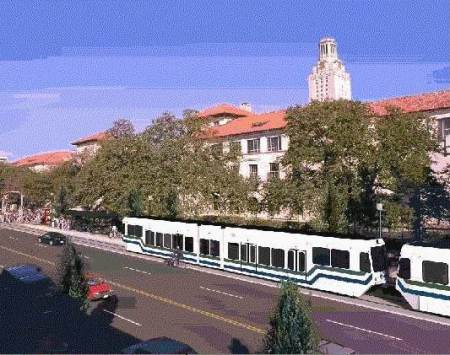

Rendition of LRT train on Guadalupe (the Drag) passing UT campus. Graphic: Capital Metro, via Light Rail Now.

Rendition of LRT train on Guadalupe (the Drag) passing UT campus. Graphic: Capital Metro, via Light Rail Now.


Running in-between and parallel to our two most congested roads, I-35 and MoPac, these trains would reinforce and complement the transit-friendly land uses that have existed in this corridor since the days streetcars plied these same streets. (See «Austin’s First Electric Streetcar Era».) Urban rail in reserved lanes on the street would deliver 40,000 riders a day to and from the city core, while experience elsewhere says that this small beginning would generate billions of dollars’ worth of new tax base for an investment of less than $750 million, half of which would likely come from the Federal Transit Administration.

Compared to rebuilding I-35 from Georgetown to San Marcos, a Guadalupe-North Lamar light rail project is a relatively simple transportation endeavor. It is a project we’d build, we’d own, we’d control, we would pay for with identified funds, and would benefit from directly — compatible with buses, biking, and walking. Plus, it would be built on a relatively predictable schedule of less than five years with an extremely high potential for payback within a decade of opening, while setting the stage for better-funded, more frequent, and more comprehensive public transit throughout the city and the region.

If 2016 is Austin’s year of mobility bonds on November’s ballot, a Guadalupe-North Lamar light rail line should be the first priority. A plan for this could be quickly assembled from at least four official past rail studies done on this corridor since 1984 — the last, a full Preliminary Engineering/Draft Environmental Impact Statement from 2000. Furthermore, it could be accomplished using the well-known competent national consulting team, AECOM, already hired by Capital Metro to essentially study the same corridor.

What’s needed now is political leadership to get it done. With our backs literally up against TxDOT’s wall of debt for an insanely risky My35 rebuild, the facts speak for themselves.

Rail References

Ridership

• Light Rail Corridor. Austin, Texas (November 2000) — Federal Transit Administration New Starts summary
https://keepaustinwonky.files.wordpress.com/2013/03/fta-new-starts_small-starts-austin-texas_light-rail-corridors.pdf

Billions in new tax base

The two best examples of initial light rail lines with similar characteristics, i.e., Big Dot connections and high ridership, are Houston and Phoenix.

• Houston METRO — $324 million to construct, opened 2004
$8 billion in economic development on initial 7.5 mile Main Street line since 2004
http://www.planetizen.com/node/81699/texas-cities-see-mass-transit-path-economicdevelopment

• Phoenix METRO — $1.351 million to construct, opened 2008
$8.2 billion in economic development on 19.6 miles Phoenix to Tempe since 2008
http://www.bizjournals.com/phoenix/news/2015/07/28/valley-metro-development-alonglightrail-tops-8.html

Other examples with more mature systems

• Dallas DART — 157% ROI, 85 miles, 61 stations
https://www.dart.org/about/economicimpact.asp

• Portland MAX (TriMet) — $4.66 billion (adjusted to 2015 $) to construct 59.7 miles of light rail with 97 stations, yielding ROI of $11.5 billion of economic development within walking distance of stations since 1986.
http://trimet.org/business/

• Salt Lake City TRAX and FrontRunner — $3.6 billion to construct 45 miles light rail and 88 miles of regional (commuter) rail, yielding ROI of $7 Billion economic development since 1999.
http://www.sltrib.com/csp/mediapool/sites/sltrib/pages/printfriendly.csp?id=2665260

h1

Capital Metro: Let’s have 2 1/2 more years of analysis paralysis

27 February 2016
Title slide of Capital Metro's CCCTA presentation to Austin City Council Mobility Committee on Feb. 3rd. Screen capture: ARN.

Title slide of Capital Metro’s CCCTA presentation to Austin City Council Mobility Committee on Feb. 3rd. Screen capture: ARN.

After months of preparation, organizing, bidding, and selection, with lots of fanfare Capital Metro at last launched its $3 million, 30-month (2.5-years) Central Corridor Comprehensive Transit Analysis (CCCTA) study. In a Jan. 25th news release, Capital Metro announced that its board of directors had selected engineering firm AECOM as the lead consultant to conduct the Central Corridor analysis.

To the uninitiated, inexperienced, and uninformed, this latest study might seem some kind of step forward for Austin’s transit development. After all, its elements include impressive-sounding goals like “An in-depth study of a variety of transportation modes and their potential for creating improved transit options within the corridor”, “A multimodal transportation plan that improves the feasibility of transit in the Central Corridor while effectively maximizing connections with regional routes in surrounding communities”, and “A realistic cost analysis for building, operating and maintaining the proposed sustainable and connected transit system”.


Capital Metro's planning chief Todd Hemingson explains CCCTA study to Austin Mobility Committee on Feb. 3rd. Photo: ARN screenshot from official video.

Capital Metro’s planning chief Todd Hemingson explains CCCTA study to Austin City Council Mobility Committee on Feb. 3rd. Photo: ARN screenshot from official video.


Analysis Paralysis gold medal

But, among grassroots public transportation advocates in Austin, it’s hard to find a transit supporter who’s enthusiastic about this study. The reason: All of these issues have already been exhaustively studied, and plans prepared and re-prepared, over and over and over and over again, for more than two decades. For Austin transit supporters, we’ve “been there, done that” — multiple times. It’s just one more repetitive “re-study of the re-studies of the re-studies ….”

To get a breathtaking idea of the time, resources, energy, and money Austin has sunk into planning for “high-capacity” public transport, just check out our February 2015 chronicle of studies and re-studies of light rail transit (LRT) in the Guadalupe-Lamar corridor: «Long saga of Guadalupe-Lamar light rail planning told in maps». This central travel corridor’s high level of traffic, population and employment density, and crucial position accessing and connecting vital activity centers (like UT, the Capitol Complex, and downtown) with key established neighborhoods and extended commercial activity along the route have made it the focus of planning for rail transit for over three decades.

In terms of public transit, Austin clearly is a top contender for the Analysis Paralysis gold medal. And Capital Metro’s latest CCCTA study, as it’s currently designed, surely represents Exhibit A toward this dubious award. The confusion, misdirection, conflicting intentions, and lack of purpose underlying this “paralysis” were discussed in our March 2015 article «Austin’s urban transport planning seems struck by catastrophic case of amnesia and confusion».

Meanwhile, as meaningful public transport planning continues to languish, the Austin metro area is experiencing a veritable blitz of intensive highway development and construction, including at least three new tollways, massive projects on I-35, and assorted projects throughout the urban area. As the saying goes, “Roads get built, transit gets studied“.

Project Connect back from the dead?

But confusion and a continuation of “analysis paralysis” aren’t the only problems with the CCCTA study. As currently configured, the study seems little more than a rehash of Project Connect’s ill-fated “High-Capacity Transit Study” which elicited such intense community outrage beginning in 2013, the precursor to its ultimate resounding rejection by voters in November 2014. Indeed, the CCCTA project seems the first major effort to resuscitate Project Connect since its 2014 debacle.

Among the worst weaknesses of the Project Connect disinterment is the revival of the seriously flawed methodology of the earlier “analysis”. This includes ignoring actual, existing travel corridors — such as the pre-eminent Guadalupe-Lamar corridor — and instead mislabeling huge chunks and sectors of the city as “corridors”. (The methodology further subdivided the “Central Corridor” into “subcorridor” mini-sectors.) Thus, according to Capital Metro, per the CCCTA study, “The Central Corridor is defined as an area bordered on the south by Ben White (US-290), on the east by the Capital Metro’s Red Line, on the north by RM 2222/Koenig Lane, and on the west by MoPac Expressway, and includes downtown Austin.”

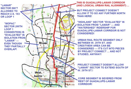
Not only is that vast glob of central Austin not a corridor, but (as in the 2013 activity) this approach slices and truncates actual travel corridors, particularly Guadalupe-Lamar, rather than analyzing them in terms of their suitability and potential for actually solving mobility problems with public transport (particularly urban rail). We analyzed the problems with this in our November 2013 article «Project Connect’s “corridor” study — without corridors!»


Infographic shows how Project Connect’s methodology segmented Guadalupe-Corridor into nonsensical pieces, and summarizes numerous other major problems. (Click to enlarge.)

Methodology of Project Connect study in 2013 labeled huge chunk of central city as a “corridor”, but severed actual intact travel corridors into meaningless pieces. Graphic: ARN. (Click to enlarge.)


Community skepticism about Capital Metro’s “corridor” methodology in the CCCTA study was illustrated as early as last September by Jace Deloney, a co-founder of the influential AURA group (involved with urban and transportation issues) and former chairman of the City’s Urban Transportation Commission and Capital Metro’s Customer Satisfaction Advisory Committee:

It’s very important that we advocate against using the previous subcorridor definitions for any future high capacity transit planning project. In my opinion, these subcorridor definitions were deliberately designed to end up with a Red River alignment recommendation.

Re-direct the CCCTA study!

Besides the exhaustive “saga” of studies of the Guadalupe-Lamar corridor detailed in the ARN article cited and linked above, Austin Rail Now and other community stakeholders have presented LRT alternative alignment and design proposals that provide more than enough basis for quickly reaching a decision for an urban rail starter line. The most recent proposals are described in several ARN articles:

Plan for galvanizing Austin’s public transport development: Light rail starter line in Guadalupe-Lamar (June 2015)

Another major Austin community recommendation for light rail transit in Guadalupe-Lamar (November 2015)

Another possible design for light rail in Guadalupe-Lamar corridor (January 2016)

So far, in the absence of any sense of direction toward a major urban rail investment, Austin’s top political and civic leadership is vulnerable to pressure by highway interests (such as TxDOT) for municipal general obligation bond funding for a heavy local investment in a massive I-35 overhaul and other huge highway projects. To this, a major rail transit starter line investment might be counter-proposed as a far more effective and desirable alternative for city bond funding.

It would definitely seem time to end Austin’s decades of “analysis paralysis” and move forward quickly toward finalizing an urban rail plan for public approval — a strategy that could be expedited by re-directing Capital Metro’s CCCTA study. There is certainly sufficient planning and design preparatory work already in place to provide the voting public a basis on which to make a decision for the Guadalupe-Lamar corridor. The AECOM consultant team (widely respected in the public transportation industry, with experience with LRT in Portland, Minneapolis, and elsewhere) could simply update and tweak the major engineering studies that have already been done (e.g., those in 1993 and 2000) for the Guadalupe-Lamar corridor.


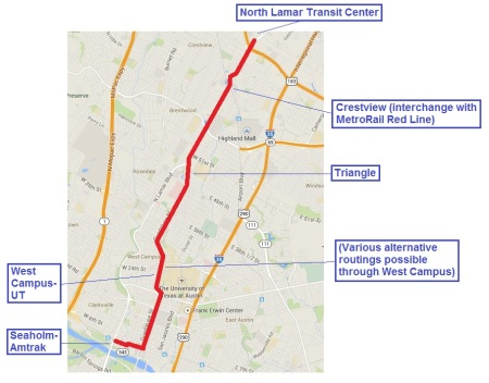
Proposed 6.8-mile "Plan B" light rail transit line in Guadalupe-Lamar corridor would have 17 stations and connect  the North Lamar Transit Center at U.S> 183 with Crestview, the Triangle, UT and the West Campus, the Capitol Complex, the CBD, and the Seaholm-Amtrak area. It's projected to serve 3 times the ridership of the Prop. 1 Highland-Riverside rail line at slightly over half the capital cost.

Austin Rail Now proposal is one of several possible configurations already suggested for light rail starter line in Guadalupe-Lamar corridor. Graphic: ARN.


This would likely require a major intervention by Austin City Council members to request Capital Metro to negotiate with its consultant team for a modification of the CCCTA work plan — eliminating the proposed 30-month “slow track” study, and re-directing the project into planning, design, and engineering of LRT for the Guadalupe-Lamar corridor as suggested above. This would have the aim of placing a measure on the ballot for bond funding (to be kept in escrow till further planning and Preliminary Engineering/Environmental Impact Study tasks are completed). Adequate cost estimates are already on hand for such a ballot measure.

According to Surinder Marwah, the former Capital Metro Senior Planner who secured federal funding for the MetroRapid bus project, this can be “a reasonable plan if the elected officials, business leaders and major stakeholders can come to an agreement” for the general Guadalupe-Lamar alignment corridor. “AECOM can update the preliminary cost estimates quickly and perform fatal flaw analysis for the alignment corridor within few months — by mid-late August to get this into [a] November ballot measure.”

Capital Metro’s currently contrived CCCTA study seems little more than a “holding pattern” reflecting the indecisiveness and lack of will of key public officials in regard to public transport policy. Re-directing this study as proposed above would at long last move Austin’s rail public transport development into a widely supported action phase and head it expeditiously toward the mobility quantum leap Austinites have so long been denied. ■

h1

Austin’s competing growth factions both continuing on road to worsening congestion

25 October 2015
CAMPO's 2040 regional roadway plan emphasizes expanding web of roadways catering to real estate development, intensifying addiction to private motor vehicle travel, and accelerating sprawl. Map: CAMPO 2040 Draft Plan.

CAMPO’s 2040 regional roadway plan emphasizes expanding web of roadways catering to real estate development, intensifying addiction to private motor vehicle travel, and accelerating sprawl. Map: CAMPO 2040 Draft Plan.

By Roger Baker

Roger Baker is a longtime Austin transportation, energy, and urban issues researcher and community activist. The following commentary has been adapted and slightly edited from his comments recently posted by E-mail to multiple recipients.

Most Austin folks still don’t know it (and how could they without much good investigative reporting?) but there is actually a behind-the-scenes struggle being conducted by two Austin-area real estate coalitions with quite different visions — a contest conducted through the agency of our federally mandated transportation planning body, Capital Area Metropolitan Planning Authority, or CAMPO.

For the time being, the more influential growth alliance which benefits from roads and more roads to serve Austin-area sprawl development has won out. There is also a distinctly different group of landed beneficiaries centered around a transition to high-level transit as the future mode choice. This policy difference is basically a long-lasting political battle between two politically influential real estate development coalitions doing normal business under somewhat unique circumstances.

Texas is a “property rights” fundamentalist state, in which unregulated land development is the rule in about the only U.S. state without county zoning. In light of this fact, it is easy to imagine why this land development policy difference would arise. Sometimes the development strategies of these coalitions coincide and at other times they don’t. But they are in complete solidarity when it comes to their support for maintaining maximum Austin-area tech-job-led population growth forever. The impossibility of doing that, as is now being planned by CAMPO, makes Texas politics all the more colorful and interesting.

Let us call these development coalitions first the “sprawler growthers” more closely allied with RECA (Real Estate Council of Austin), and with fast land deal profiteering their uppermost consideration. The other policy bloc is the “transit growthers“, more allied with the Chamber of Commerce and Project Connect, based on somewhat more of a long-term sustainable growth vision. The latter transit-supportive, somewhat smarter-growth coalition recognizes that with congestion becoming a major challenge to maintaining Austin’s tech-based growth, and buses caught up in the same congestion, this leaves only old-fashioned, high-level rail to serve on travel corridors like Lamar/Guadalupe. There is no other way to maintain what still remains of Austin’s severely degraded peak hour travel mobility.

Former Austin Mayor Lee Leffingwell was forced by RECA, which is the more sprawl oriented development coalition, to include $400 million in roads into his rail bond package, which ballooned it to a full billion dollars, using up all the city’s remaining high-grade bonding ability, and likely priming it for defeat. With the defeat of the billion-dollar bond package election in November 2014, and with the recent approval of the heavily sprawl-oriented CAMPO plan favored by TxDOT and the Central Texas Regional Mobility Authority (CTRMA), the sprawl-growth faction now has the upper hand. They are proceeding to build and widen roads as fast as their increasingly limited finances allow, as I’ve recently reported in a Rag Blog article:

http://www.theragblog.com/roger-baker-metro-risky-business-in-central-texas-the-toll-road-bond-gamble/

The recent Travis County support for bringing the Rocky Mountain Institute into the Austin area planning process to tackle Austin congestion can’t change this unhappy reality very much. Nothing can solve problems that really stem from decades of anarchistic sprawl development, and at this late stage in the urban development process.

Now that Uber has created and promoted software that undermines certain traditional inefficiencies of the taxicab industry, there isn’t much to be done there. Capital Metro has gotten a new app that makes it possible for riders to track buses, but these buses are still largely trapped in congestion at peak, which remains their main problem. Squeezing what advantages are left to develop through wider use of telecommuting to eliminate physical travel might help some, but new breakthroughs in that area are getting hard to find.

Much slower regional growth will no doubt win out as the obvious resolution in the end. When things can’t go on any longer, they don’t. ■

h1

Plan Now for Light Rail in South Lamar!

29 April 2015
South Lamar corridor. Map: City of Austin.

South Lamar corridor. Map: City of Austin.

By Lyndon Henry

The following comments, adapted here to webpage format, were distributed to attendees at a public event sponsored by the City of Austin’s South Lamar Boulevard Corridor Study project on 10 December 2014. Lyndon Henry is a transportation planning consultant, a technical consultant to the Light Rail Now Project, and a contributing editor to Austin Rail Now. His comments highlight the vision of Austin Rail Now and other transit advocates that light rail is justified in, and needs to be planned for, a number of the Austin area’s major travel corridors.

► South Lamar light rail transit line makes sense

• In terms of both travel density and traffic congestion, South Lamar Blvd. ranks high among Austin’s major travel corridors (see Latest TTI data confirm — Guadalupe-Lamar is central local arterial corridor with heaviest travel). Current travel density plus rapidly increasing population density plus commercial growth in this corridor all indicate that planning for light rail transit (LRT) should long since have been under way.

• A South Lamar surface LRT line, possibly using an alignment design such as is illustrated below, needs to be a major part of an eventual citywide system branching north, south, east, and west throughout our region from an initial central spine in the Guadalupe-North Lamar corridor.


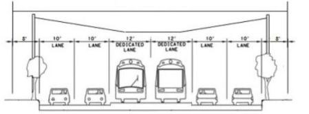
Cross-sectional diagram showing how center LRT reservation could be inserted in South Lamar, maintaining traffic lanes and sidwalks. Design would use side-mounted traction electrification system poles for suspending the overhead contact system for LRT electric propulsion. Graphic: ARN. (Click to enlarge.)

Cross-sectional diagram showing how center LRT reservation could be inserted in South Lamar, maintaining traffic lanes and sidwalks. Design would use side-mounted traction electrification system poles for suspending the overhead contact system for LRT electric propulsion. Graphic: ARN. (Click to enlarge.)


• The South Lamar Corridor Improvement Program should be reconfigured to include planning for LRT as a crucial focus of this project. Planners and traffic engineers need to ensure that any “improvements” in this corridor facilitate dedicated transit lanes for future light rail, and certainly should not impose obstacles to it. It’s way past time to scrap the practice of proceeding with major projects with little if any thought to the future.

► Form a Community Policy & Technical Oversight Committee

• Planning should involve the Austin community as a whole, and this means forming a broad, inclusive community committee to oversee policy and technical decisions, including a comprehensive transit-focused mobility plan for Austin and its surrounding region. No more secretive project teams meeting in a virtual “bunker”, then emerging to tell us what they’ve decided for us! Authentic public participation means including representatives of neighborhood and other community groups, plus others with applicable expertise within the Austin community at large.


Current view of traffic on South Lamar. Photo: Austin Mobility.

Current view of traffic and urban development on South Lamar. Photo: Austin Mobility.


► Dedicate street lanes for light rail transit

Light rail can carry many more peak passengers than private cars, and attract many more riders than buses (both “regular” and MetroRapid). Austin needs to start re-allocating street space from traffic lanes to transit lanes, and the South Lamar corridor must be included. Smart design could install LRT in this corridor while retaining at least 4 lanes of traffic (see diagram in first section, above). ■

h1

Austin’s urban transport planning seems struck by catastrophic case of amnesia and confusion

29 March 2015
Graphic: Rich's Management Blog

Graphic: Rich’s Management Blog

The devastating befuddlement of Austin’s official-level urban transportation planning over the past five months has been nothing short of jaw-dropping. Especially when you consider this in context.

For two and a half decades, local officials and planners have explained why urban rail — affordable light rail transit (LRT), in Austin’s case — has been an absolutely essential component of the metro area’s mobility future. As our recent article «Long saga of Guadalupe-Lamar light rail planning told in maps» describes, the logical starting point for an initial LRT route has been the central city’s heaviest-traveled central corridor, Guadalupe-Lamar.

Year after year, planning proceeded in some way for LRT. Even after 2003, while official planning was distracted and mis-directed toward potential routes more to the east of the central core city, the need for rail transit was still proclaimed. Austin had to have rail to maintain an adequate level of mobility into the future.

Beginning about 2006, an original streetcar “connector” rail transit concept emerged that gradually morphed into more ambitious “urban rail” — a full LRT system. An official blue-ribbon committee of civic leaders, the Transit Working Group (TWG), was hand-picked (first by State Sen. Kirk Watson, then by Austin Mayor Lee Leffingwell) to guide rail planning. Extensive planning documents were finalized for a route scheme linking the Core Area with Seaholm, East Riverside, the East Campus, and Mueller — a rather deranged route, in our view, but rail nonetheless. The City then launched a full-fledged NEPA (National Environmental Policy Act) process (required for federal funding), with a series of “open houses” and other public events.

Activities of the TWG continued to heat up, primarily focused on planning for the urban rail line to Mueller. Route alternatives, cost issues, funding issues, organizational and management arrangements, and all kinds of associated issues were discussed exhaustively. A new consortium of public agencies, called Project Connect, was formed, mainly to coordinate rail planning and to produce a massive regional plan criss-crossed with proposed rail lines. Remember all this?

By 2013, the official establishment apparently felt urban rail needed the scrutiny of a special High-Capacity Transit study. So a special Project Connect team, headed by consultant Kyle Keahey, was formed, and virtually the second half of 2013 was consumed with “studying” (translation: justifying) and finalizing the need, size, and shape of an officially preferred urban rail plan. Mueller was sidelined, replaced by a desperate quest for a rail line from East Riverside to the former Highland Mall site. “Gotta get to Mueller! Mueller! Mueller!” became “Gotta get to Highland! Highland! Highland!”


Urban rail has been on the official planning agenda for decades. Throughout the first 10 months of 2014, the Highland-Riverside plan (envisioned in this simulated scene) was hyped incessantly. Graphic: Project Connect.

Urban rail has been on the official planning agenda for decades. Throughout the first 10 months of 2014, the Highland-Riverside plan (envisioned in this simulated scene) was hyped incessantly. Graphic: Project Connect.


As this blog, and a sizable segment of local transit advocates, insisted, the plan was conceived for the wrong reasons and fundamentally flawed. But for about the last two months of 2013, and ten months of 2014, the City administration, plus Capital Metro, plus the prevailing faction of local civic leaders, all insisted over and over that rail was absolutely, positively essential (although it had to be the peculiar Highland-Riverside plan officials had concocted). An expensive ad campaign, much of it financed from federal funds channeled through Capital Metro, bombarded the public via the Internet and virtually all major media outlets — reiterating the message that traffic congestion was a growing threat to the metro area and rail (the official plan of course) was the essential remedy. Mayor Leffingwell’s familiar aphorism was suddenly appearing and being heard everywhere: “Rail or Fail!

And then, on Nov. 4th, it all hit a wall, as voters said No to the puzzling, nonsensical, controversial, and fabulously expensive Project Connect plan that had been offered.

And all of a sudden, rail was erased, scrubbed, from official discourse. Despite all the years, decades, of documentation of the need for a rail transit system for the city, the official vision of transit became refocused on “becoming the best bus system we can be”; after years of explanations that reliance on further highway development wasn’t a realistic solution for preserving the city’s mobility, regional highway and tollway development has suddenly received a new surge of energy in official policy.

Meanwhile, rail transit planning has basically vanished from official planning. It’s just gone “Poof”. As David Orr has reported in his recent commentary «Austin’s “shadow government” (CAMPO) disappears light rail from local planning», all reference to urban rail has been expunged from the 2040 Transportation Plan of CAMPO (Capital Area Metropolitan Planning Organization), and replaced by line items for “bus rapid transit” (i.e., expansion of the MetroRapid limited-stop bus service).

Affirmed, until last November, as an absolutely essential component of Austin’s future mobility, light rail has now disappeared from public discourse, from the mainstream media, from the lips of politicians and civic leaders. Is it some kind of collective amnesia? Have the local planning and decisionmaking establishment all been struck with a strange disability, like the global mass blindness in Day of the Triffids? Or is the obliteration of rail a calculated excision, like the Soviet Stalin regime’s air-brushing elimination of political undesirables from photos, or the “Photoshopping” of group photos by some misguided religious media to “disappear” women?


Evaporation of Austin's light rail planning resembles a catastrophe of collective affliction, like the mass blindness portrayed in Day of the Triffids. Movie poster: IMDb.com.

Evaporation of Austin’s light rail planning resembles a catastrophe of collective affliction, like the mass blindness portrayed in Day of the Triffids. Movie poster: IMDb.com.


One wonders whether any of these Austin-area leaders and planners have given a thought as to how this plays in public perceptions of their own credibility and integrity. Were all the assurances and explanations of the need for urban rail to maintain Austin’s future mobility and vitality just deceptive hype, a marketing ploy for some kind of alternative agenda?

Maybe, but we believe the fundamental case for LRT in Austin has been grounded in truth — the higher capacity, greater ridership attraction, cost-effectiveness, environmental benefits, unsurpassed magnetism to transit-oriented development and economic development, and other advantages of light rail are indeed essential for the future of this community. Mobility cannot be sustained of a continuing expansion of rivers of highways and tollways and a steadily rising flood of personal motor vehicles. Urban rail continues to be key to providing truly attractive public transit alternative, and shifting at least significant segments of the Austin metro to a sustainable alternative mobility lifestyle.


According data from Texas Transportation Institute, even with implementation of infrastructure expansion in CAMPO 2035 plan, Austin metro travel time would increase 80% due to traffic congestion. Graph: Austin Chamber of Commerce 2013 Mobility Report.

According to data from Texas Transportation Institute, even with implementation of infrastructure expansion in CAMPO 2035 plan, Austin metro travel time would increase 80% due to traffic congestion. Graph: Austin Chamber of Commerce 2013 Mobility Report. (Click to enlarge.)


And we have a strong suspicion that a preponderant number of local planners and officials actually continue to agree with this perspective. If so, they need to realize there’s a lot of community support for urban rail — from voters on both sides of last year’s debate — and they need to start stepping forward. They need to heed their sense of responsibility, find their mojo, or whatever it takes, to take the lead to get LRT planning back on track.

The groundwork, in terms of preliminary planning, is already there — and, in recent articles and other public information, Austin Rail Now along with other mass transit advocates have expanded on it.

Austin is waiting. We’re wondering who’ll take the first step. ■


LRT train on Portland's 5th Ave. transit mall swings to the curbside station to pick up waiting passengers. Photo: L. Henry.

Portland’s light rail trains (in dedicated lanes) share 5th and 6th Avenue transit mall with buses as well as cars — a potential transit design model for Austin? Photo: L. Henry.

h1

Austin’s “shadow government” (CAMPO) disappears light rail from local planning

26 March 2015
Graphic: PEHUB.com

Graphic: PEHUB.com

By David Orr

David Orr, an Austin community activist involved with transportation issues, is a longtime environmental justice and transportation advocate.

The more I learn about how the political sausage gets made around here nowadays, the more I’m convinced that CAMPO (Capital Area Metropolitan Planning Organization) is Austin’s “shadow government“, at least so far as large-scale transportation-related land use decisions are concerned.

The CAMPO 2040 Plan is egregiously deficient in providing alternatives to automobile-based transportation. Indeed, it seems like the plan is designed — intentionally so — to ensure that development of efficient rail-transit infrastructure cannot occur.

From what I’ve read, there are exactly ZERO miles of light rail in the plan, whereas a decision has apparently been made to go all in on BRT (bus rapid transit). It’s not clear to me where, or by whom, the decision was made to pretend light rail is no longer an option, but the fact that this policy is embedded so deeply in CAMPO’s planning documents makes clear that the agency has a clear agenda.

CAMPO 2040 Plan includes hundreds of millions of dollars for additional investment in MetroRapid "BRT" operation. Such facilities could impose a barrier to urban rail in key corridors such as Guadalupe-Lamar. Photo: L. Henry.

CAMPO 2040 Plan includes hundreds of millions of dollars for additional investment in MetroRapid “BRT” operation. Such facilities could impose a barrier to urban rail in key corridors such as Guadalupe-Lamar. Photo: L. Henry.

Where is the political accountability for this? Have local governments adopted resolutions of support for BRT while unequivocally stating opposition to any further study of light rail?

It seems to me that citizens have to demand that the City of Austin and Travis County — the most populous city and county in the CAMPO region — respond to CAMPO’s 2040 Plan before it is finalized next month (April). Even though it seems that the majority of CAMPO’s board have made it clear that their priorities are not in synch with concerns of Austin and Travis County officials who would like to see less emphasis on highway construction, it should be incumbent on both local entities to stand up for the interests and concerns of the residents here.

If CAMPO adopts a plan that zeros out light rail for the next 25 years, that will greatly complicate any effort that we can marshal to promote a light-rail project. I’m not well-versed in U.S. DOT (Department of Transportation) and FTA (Federal Transit Administration) law and regulations, so I don’t know whether an Austin-based light-rail project would have to obtain CAMPO’s support to proceed, but the FTA surely would notice if CAMPO was not behind it. Another crucial question is whether the Austin City Council or the Travis County Commissioners would be inclined to object to the finalizing of the 2040 Plan.

Light rail/urban rail has simply vanished from CAMPO's 2040 Transportation Plan. Screenshot of Urban Transit page: ARN.

Light rail/urban rail has simply vanished from CAMPO’s 2040 Transportation Plan. Screenshot of Urban Transit page: ARN. (Click to enlarge.)

During CAMPO’s meeting on the night of March 9th, the agency’s director stated that they were required by federal rules to adopt this plan in the next month or two. If that’s true, such a requirement may make it impossible to stop this measure, but at least the city and/or county could register official displeasure (and preferably opposition?) at the lack of public input on so many key policies and plan provisions.

I encourage others to join me in expressing concern publicly. If you have a good relationship with friendly elected officials, it seems like this is a critical time to ask them to engage. ■

h1

Baker: CAMPO’s 2040 plan = “prescription for intense and auto-addictive suburban sprawl development far into future”

16 February 2015
Suburban highways, freeways, and tollways like Loop 1 (MoPac) have driven suburban sprawl, forcing dependency on personal motor vehicles for nearly all local transportation. CAMPO's planning continues to be focused mainly on promoting suburban growth through further roadway expansion. Photo: CTRMA.

Suburban highways, freeways, and tollways like Loop 1 (MoPac) have driven suburban sprawl, forcing dependency on personal motor vehicles for nearly all local transportation. CAMPO’s planning continues to be focused mainly on promoting suburban growth through further roadway expansion. Photo: CTRMA.

By Roger Baker

Roger Baker is a longtime Austin transportation, energy, and urban issues researcher and community activist. The following commentary has been adapted and slightly edited from his comments recently posted by E-mail to multiple recipients.

On February 9th, CAMPO (the federally sanctioned Capital Area Metropolitan Planning Organization) held its monthly meeting, as usual to discuss regional planning policies. Although these tend to resemble (and to some extent overlap with) the City of Austin’s own planning issues, CAMPO’s anti-environmental, pro-sprawl policy governs state policy and the disposition of federal money, and thus tends to overrule Austin’s policies. So Austinites involved in local urban planning and transportation issues should take some interest.

Following is a link to the CAMPO agenda. I’d recommend reviewing Items 6A and 6B in particular, which discuss the new long-range 2040 CAMPO plan. When approved in May, this will lock-in regional funding and construction priorities policy for this new $32 billion 2040 plan:

http://www.campotexas.org/wp-content/uploads/2015/02/TPB-Agenda-February-9-2015.pdf

This CAMPO plan currently in the works, and nearing approval as our top regional infrastructure policy, seeks to double the Central Texas population to about 4 million, while putting most of the future population increase In Hays and Williamson Counties. This amounts to a prescription for intense and auto-addictive suburban sprawl development far into the future.

If you feed the projected sprawl-related commuter demand into CAMPO’s secretive travel demand model, you get nightmare-ish congestion throughout the region in 2040, as CAMPO has had to admit. I wrote about that here (my apologies for the misspelling of “congestion”):

http://changeaustin.org/2014/11/campos-congetion-nightmare/

This nightmare presents CAMPO with a political problem — trying to explain how it makes sense to spend $32 billion in fanciful future money only to see congestion get much worse than now, and what happens to congestion without this optimistic funding.

The CAMPO politics of planning policy assumes that the special interests tied to land development proceed as usual. The whole effort amounts to damage control. Congestion is treated like a dragon to be slayed mostly by roads, a process unconstrained by rational land use planning.

One response to CAMPO’s political problem of horrible modeled congestion is to use various behavior change assumptions to make future travel demand disappear, effectively by edict, by a united proclamation of the travel modelers and politicians.

The CAMPO planners have now managed to generate enough driver trip demand assumptions that they make more than 50% of the total Austin’s travel demand disappear as if by magic. This process is called Transportation Systems Management, which makes Austin’s future congestion picture, if still bad, look a lot better, despite CAMPO’s huge predicted level of sprawl development ringing Austin.

According to agenda Item 6A in the agenda linked above:

Staff is developing an analysis section similar to the analysis conducted by the Greater Austin Chamber of Commerce for their 2013 Mobility Report. This analysis will quantify the estimated congestion reduction benefit achieved by implementing 2040 Plan projects as well as additional travel demand management (telework, peak-shift and mode-shift) and transportation system management (operational improvements) strategies. Staff is also preparing a qualitative analysis of the CAMPO activity centers as a land use strategy.

And according to Item 6B:

PURPOSE AND EXECUTIVE SUMMARY

CAMPO staff and modeling consultants are developing a needs analysis for the draft CAMPO 2040 Plan which is similar to the analysis conducted by the Texas A&M Transportation Institute for the Greater Austin Chamber of Commerce 2013 Mobility Report. The analysis will quantify the estimated congestion reduction benefit achieved by implementing 2040 Plan projects as well as additional travel demand management (telework, peak-shift and mode-shift) and transportation system management (operational improvements) strategies. Staff and consultants developed assumptions regarding the implementation rates of the strategies so that the analysis will reflect reasonable results. Staff is requesting that the TAC review and provide input on the assumptions.

However, you won’t find this miracle of congestion reduction anticipation spelled out in CAMPO’s agenda. You would have to know just where to look. Here is where you can go to find the details:

http://www.campotexas.org/wp-content/uploads/2015/02/TAC-Presentation-January-2015.pdf

Scroll down to slide #29 where the future improvements contributing to future traffic flow are quantified in a tiny blurry side box as follows:


Assumed capacity impacts of Transportation System Management measures. Table: CAMPO Technical Advisory Committee.

Assumed capacity impacts of Transportation System Management measures. Table: CAMPO Technical Advisory Committee.


Grand total = 51.15% (assumed) total future trip demand reduction!

You can see these assumed policies/impacts also by going to the end of section 4B “Assumptions for Needs Analysis”, or scrolling down to page 55 of this other PDF file, and finding the list of policies in a box:

http://www.campotexas.org/wp-content/uploads/2015/01/TAC-Agenda-January-28-2015.pdf

Also see the same info at my Google link here:

https://drive.google.com/file/d/0B9kg5NdhKh8RSGhvVjg3aTBRb28/view

All this begs the question of why, assuming these congestion reduction policies can really work as claimed, CAMPO doesn’t put the highest policy priority on reducing our traffic demand 50% in these various ways immediately, instead of waiting any longer.

Are there really examples of this much telecommuting-led travel demand reduction on this scale, or this much voluntary peak travel time shifting? Are there local engineering reports to add credibility to the claimed travel reductions from the various suggested signal policies? How credible is CAMPO’s claim of over 50% demand reduction? If we do this stuff, will we still need rail that bad, or is it already assumed in the “Intermodal Transportation Projects” share of demand reduction?

Bottom line:

Business as usual. Sprawl land developers make no sacrifices, while taxpayers and drivers do all the heavy lifting and funding, and supposedly change their behavior enough to make more than half the projected travel demand go away.


Barton Creek Resort development near Loop 360. Lower-density suburban development, facilitated by publicly funded highway expansion, is virtually impossible to serve effectively and affordably by mass transit — and this leads to near-total dependency on personal motor vehicles for mobility. Photo: Mopacs, via Skyscraperpage.

Barton Creek Resort development near Loop 360. This kind of lower-density suburban development, facilitated by publicly funded highway expansion, and widespread throughout the Austin region, is virtually impossible to serve effectively and affordably by mass transit — and this leads to near-total dependency on personal motor vehicles for mobility. Photo: Mopacs, via Skyscraperpage.

h1

Long saga of Guadalupe-Lamar light rail planning told in maps

10 February 2015
Red highlighting line demarcates North Lamar Blvd. and Guadalupe St., north-south central spine of Guadalupe-Lamar travel corridor. (Click to enlarge.)

Red highlighting line demarcates North Lamar Blvd. and Guadalupe St., north-south central spine of Guadalupe-Lamar travel corridor. (Click to enlarge.)

Last October, in our article titled «Latest TTI data confirm — Guadalupe-Lamar is central local arterial corridor with heaviest travel», this website noted that “For years, many Austin public transit activists have been insisting that the Guadalupe-Lamar (G-L) corridor is the central inner city’s most heavily traveled local travel route, and should be the first priority for installing urban rail.” As the article further explained:

By far, the heavy travel flow in this corridor one of that most compelling features that cry out for the capacity, public attractiveness, and cost-effectiveness of urban rail (light rail transit, LRT). Study after study has documented the fact that this is the most intensely traveled inner-city local corridor — the only major corridor serving the city’s central axis between I-35 and Loop 1 (MoPac).

Now, the latest annual report of the Texas Transportation Institute (TTI), endorsed by the Texas Department of Transportation (TxDOT) not only strongly corroborates these assessments, but provides data that further emphasize the key importance of the G-L corridor.

The article summarized the TxDOT data with several graphs showing that, in both traffic and mobility congestion, Guadalupe-Lamar surpasses all other major local arterial corridors in the city. Conclusion: Once again, “Good sense suggests that Guadalupe-Lamar remains the top-priority corridor for an urban rail starter line.”

This conclusion merely corroborates a reality that has changed relatively little in more than 50 years — a saga of planning for this crucial central corridor that can be more fully grasped in the following series of maps spanning over five decades.

Central Freeway plan

As early as 1962, the Guadalupe-Lamar corridor was proposed as the route of a Central Freeway (also designated a Central Expressway) in a regional transportation plan produced by the Texas Highway Department (predecessor of the Texas Department of Transportation, TxDOT). The map below, an excerpt from the larger 1962 regional map in the official report, zooms in on roadways planned for central Austin, with proposed freeways shown as dashed red lines. We’ve annotated the Central Freeway in the Guadalupe-Lamar corridor (running north-south just to the left of center) with an additional yellow line in the middle of the red.


Central Freeway (annotated here with yellow line in center of dashed red line). (Click to enlarge.)

Central Freeway (annotated here with yellow line in center of dashed red line). (Click to enlarge.)


The prospect of a new freeway slicing through established neighborhoods like Hancock, Hyde Park, and the West Campus eventually prompted interest in a rail transit alternative for the corridor. This is noted in the following information from the Texas Freeway website, which provides a verbal narrative of the proposed Central Freeway route:

Central Freeway Starting downtown just west of the Capitol, this freeway would have been located a block or two west of Guadalupe and proceeded northward up to the UT campus, where it would join Guadalupe and follow Guadalupe northward to Koenig lane. It then curved to follow the route of Lamar street. A light rail line was planned for this route in 2000, but was narrowly rejected by Austin voters in November 2000. In the long run, there is still a very good chance that light rail will be built on this route.

Past light rail plans

The prominence of the Guadalupe-North Lamar travel corridor, the need to effectively provide access to major core activity centers including the University of Texas campus, the Capitol Complex, and downtown, plus the looming prospect of a major freeway to cut through the heart of the city, prompted strong interest in exploring public transit alternatives. Starting in the 1970s, these began to emerge.

► CARTRANS proposal — The possibility of rail transit as an effective and plausible alternative to the Central Freeway for Austin’s central Guadalupe-Lamar corridor emerged decisively in 1973 via the release of A Preliminary Feasibility Study for a Capital Area Rapid Transit System (with the acronym CARTRANS). Prepared by Lyndon Henry, a leader of Texas Association for Public Transportation (TAPT), with the collaboration of Phil Sterzing, a former Austin city planner, the plan proposed a 19.2-mile electrically propelled light transit (LRT) line running in a subway and on elevated structure through the heart of the center-city, then on surface railway alignments north and south. (Lyndon Henry is currently a contributing editor to this website.)


CARTRANS report (left) proposed LRT 19.2-mile route (right) stretching from north to south Austin and paralleling major central flow of travel along North and South Lamar, South Congress, and I-35. Photos: ARN.

CARTRANS report (left) proposed LRT 19.2-mile route (right) stretching from north to south Austin and paralleling major central flow of travel along North and South Lamar, South Congress, and I-35. Photos: ARN.


Published by the Washington, DC-based RAIL Foundation, the CARTRANS report quickly garnered interest and support from the Austin City Council and much of Austin’s top civic leadership. This catapulted rail transit — previously disparaged as inappropriate for any Texas city — into a possibility under serious consideration as a realistic public transit alternative for the central city.

► Capital Metro planning in early 1990s — After approximately a decade of additional transit planning conducted mainly via the Austin Transportation Study, civic interest and public excitement over the possibility of an Austin rail transit system (particularly as an alternative to the metro area’s increasingly congested and dangerous roadways) helped facilitate creation of the Capital Metropolitan Transportation Authority (CMTA, Capital Metro) in 1985. Subsequently, the agency’s initial major planning effort, the Transitway Corridor Analysis Project (TCAP), having concluded in 1989 with robust community involvement, led to the designation of LRT as the agency’s Locally Preferred Alternative (LPA, a federally required decision).

Also emerging from the TCAP experience was the concept of connecting access to the northwest metro area, via the City of Austin’s newly acquired railway line, with the Guadalupe-Lamar corridor, serving multiple destinations, established and high-density neighborhoods, the University of Texas (UT), Capitol Complex, and downtown. In addition, most local transit advocates, including TAPT, as well as local planners and decisionmakers realized that a surface LRT system (rather than significant subway or elevated infrastructure) was best suited for Austin’s scale and financial resources.

Beginning in the early 1990s, Capital Metro contracted with a consulting team led by E.P. Hamilton & Associates to conceptually design and evaluate a surface-routed electric LRT alignment to serve primarily the Guadalupe-Lamar corridor plus a segment of Austin’s northwest corridor, served by available “opportunity assets” including the now publicly owned railway line as well as the major arterials North Lamar and Guadalupe St. Also included was a short additional spur into East Austin, using a segment of the same CMTA railway. As with all such proposals, this was envisioned as merely a “starter line”, seen as the first crucial leg of an ultimately multi-route system serving the entire metro area.

The eventual plan, finalized by a Light Rail Transit Station and Corridor Area Planning consultant team led by Carter Design Associates, in association with 6 other consulting firms, proposed a 14-mile starter line route running from Parmer Lane southward to the CBD. From Parmer to U.S. 183 the route uses the CMTA railway right-of-way; alternative routes using U.S. 183/North Lamar or the railway are proposed from there to Justin Lane; then the route follows Lamar, Guadalupe, and Lavaca into the CBD, with the already mentioned branch into East Austin. The plan was projected to have a total investment cost of $244 million (1992 dollars), with opening targeted for 2000, and daily ridership forecast as 34,900 in 2010. The route map and key features are summarized in the following informational page from Capital Metro, dated April 1994:


Capital Metro LRT plan for Guadalupe-Lamar and northwest, 1994. Map: CMTA. (Click to enlarge.)

Capital Metro LRT plan for Guadalupe-Lamar and northwest, 1994. Map: CMTA. (Click to enlarge.)


► Capital Metro 2000 LRT plan — During the mid-to-late 1990s, Capital Metro changed course somewhat to focus on a possible diesel-operated rail service exclusively on the agency’s railway. Mainly because of this, and political and organizational upheavals at Capital Metro, the 1994 plan was effectively shelved … only to be resurrected, almost intact, in 1999-2000 by a reorganized Capital Metro board chaired by tech industry executive Lee Walker. In a charette convened by the agency, dozens of national transit industry professionals reaffirmed the primacy of the Guadalupe-Lamar and northwest travel corridors, and endorsed the need for a line very similar to the 1994 proposal.

Assisted by the Parsons-Brinckerhoff consulting firm, Capital Metro planners devised an LRT plan intended to be funded 50% with Federal Transit Administration (FTA) grants. As described in our article «Austin’s 2000 light rail plan — Key documents detail costs, ridership of Lamar-Guadalupe-SoCo route», “Capital Metro’s proposal was sectioned into two parts — a shorter Minimum Operable Segment (MOS), running from McNeil Rd. in north Austin — using railway right of way (now used by today’s MetroRail), then Lamar-Guadalupe — to the CBD, and a full Phase 1 plan, which added a line down South Congress to Ben White, and another branch on Capital Metro’s railway right of way to Pleasant Valley Rd.”

The MOS (McNeil Rd. to CBD) consisted of a 14.6-mile initial starter line segment, with ridership for the forecast year (2025) projected at 37,400 per day. The complete Phase 1 plan — adding the South Congress (SoCo) extension, plus a branch into East Austin, comprised 20.0 miles of route. These are shown in the following map from the FTA’s New Starts report on the project:


Capital Metro's 2000 MOS (dashed line) and full Phase 1 light rail plan. Map: FTA.

Capital Metro’s 2000 MOS (dashed line) and full Phase 1 light rail plan. Map: FTA. (Click to enlarge.)


While Capital Metro’s LRT initiative was rejected in a November 2000 referendum, it lost by less than one percentage point — and actually got a solid majority vote within the City of Austin itself. This thread of public support would help keep the project alive.

► Rapid Transit Project planning — Because of the very narrow margin of the loss in the 2000 LRT plan vote, and the clear evidence of support from City of Austin voters, following the 2000 election Capital Metro and the City of Austin established a joint Rapid Transit Project (RTP) that continued planning, with a focus on the Guadalupe-Lamar corridor as well as a potential alignment on Capital Metro’s railway to the northwest. While several alternative segments were considered (including a subway option, which was discarded), the primary route through the heart of the central city remained Guadalupe-Lamar, as indicated in the following annotated map disseminated in April 2002 by the RTP:


Route alternatives considered by the City-Capital Metro joint Rapid Transit Project, as presented in 2002. Guadalupe-Lamar remained the heart of the plan's route into the Core Area, as shown by the red line. Map: RTP. (Click to enlarge.)

Route alternatives considered by the City-Capital Metro joint Rapid Transit Project, as presented in 2002. Guadalupe-Lamar remained the heart of the plan’s route into the Core Area, as shown by the red line. Map: RTP. (Click to enlarge.)


During this period, intensive planning for LRT, particularly in the G-L corridor and downtown, continued, with vigorous public meetings and consultations. Included in these activities was the extensive involvement of community activists and residents of neighborhoods along the proposed route, much of it focused on developing and finalizing neighborhood station-area plans with the aim of effectively utilizing the anticipated resource of LRT.

These planning efforts continued until the RTP’s activities were effectively curtailed and eventually terminated as Capital Metro abruptly ended planning for LRT in the G-L corridor in mid-2003 and turned instead to developing a diesel-operated “urban commuter rail” line (in effect, a revival of a very similar concept from the mid-1990s). That effort led to voter endorsement of the plan in November 2004, and the Red Line, rebranded as MetroRail, opened in the spring of 2010.

However, as this website has related in our Nov. 2014 article «Derailing the Mueller urban rail express — Preamble to Project Connect’s 2013 “High-Capacity Transit Study”», unlike the LRT plan that would run straight to Austin’s Core Area, the new diesel-multiple-unit (DMU) operated system lacked this access: “Since the newly approved DMU line ran on a railway alignment that bypassed most of the heart of the city, ending only at the southeast corner of the CBD, officials and planners realized they needed some way to connect passengers with key activity points, including UT and the Capitol Complex.”

This led officials and planners to try to solve the problem with various schemes, including “connector” buses, then the MetroRapid bus project, and some kind of rail “circulator” that would connect the commuter-like MetroRail with key destinations. As our article cited above explains, a streetcar scheme morphed into a more robust LRT concept that included both a route on East riverside Drive and a more central line running through the east side of downtown, UT’s East Campus on San Jacinto Blvd., and on into the Mueller site, first via Manor Road, then eventually via a route using Red River St., Hancock Center, and Airport Blvd. to access Mueller. Any vestige of LRT in the city’s most heavily traveled central local arterial corridor — Guadalupe-Lamar, including access to the West Campus and the business commercial district and established neighborhoods along it — was abandoned.

Current light rail plans

But while the obsession of Austin’s local political establishment and official planners had turned to a route apparently motivated in part by a desire to bolster real estate development plans at Mueller and East Riverside, and the UT administration’s East Campus expansion plans, local community activists and public transit activists continued to call attention to the abiding need for LRT in the Guadalupe-Lamar corridor. It was clear years ago, and now, that reliable data has continued to corroborate what Austinites can themselves see and experience — that this is the most important, heavily traveled local corridor in the heart of the city. See, for example, data cited in our articles:

Demographic maps show Lamar-Guadalupe trumps Mueller route for Urban Rail

Guadalupe-Lamar urban rail line would serve 31% of all Austin jobs

Guadalupe-Lamar is highest-density corridor in Austin — according to Project Connect’s own data!

Latest TTI data confirm — Guadalupe-Lamar is central local arterial corridor with heaviest travel

This community involvement, including the efforts of TAPT and the Light Rail Now Project, has led in more recent years to a series of alternative proposals for LRT/urban rail alignments in the Guadalupe-Lamar corridor, as described below.

► TAPT “loop route” — In May 2012, responding to an official proposal for a 5.5-mile, $550 million “urban rail” line running from downtown, through the East Campus, to Mueller, TAPT leaders Dave Dobbs and Lyndon Henry presented an alternative $700 million plan for 14.7 miles of LRT serving both the Guadalupe-Lamar corridor and the eastside Red Line corridor. Connected at both north and south ends where the west and eastside lines would converge, the route thus formed a “loop” around the heart of the city. A branch serving the Mueller site was also included. (When an estimated $150 million was added into the official “urban rail” plan — accounting for a projected “BRT” line in the G-L corridor — the TAPT “loop” proposal matched the cost of the official concoction of rail + “BRT”.)

The route proposed in this plan, described in our March 2013 article «An alternative Urban Rail plan», is illustrated in the original map below:


TAPT "loop" plan from the early summer of 2012 proposed a 14.7-mile route "looping" around the heart of the central city, including a line in the G-L corridor, plus a branch to Mueller. Map: TAPT. (Click to enlarge.)

TAPT “loop” plan from the early summer of 2012 proposed a 14.7-mile route “looping” around the heart of the central city, including a line in the G-L corridor, plus a branch to Mueller. Map: TAPT. (Click to enlarge.)


► CACDC proposal — In this general period, prior to the start of Project Connect’s “High-Capacity Transit Study” activities in the late summer of 2013, the Central Austin Community Development Corporation (CACDC), led by Scott Morris, posted maps and data for a seven-mile-long Central Corridor urban rail plan following North Lamar and then Guadalupe. As described in our article «Another alternative urban rail plan for Guadalupe-Lamar corridor»,

The CACDC route would extend from the North Lamar Transfer Center, down North Lamar past the Crestview station, through the West Campus area, to 4th St. From there, it includes an eastward spur to the Seaholm development site, and also proposes a short spur line branching from the existing MetroRail Red Line into the Mueller development site.


CACDC's Central Corridor urban rail plan (blue), with MetroRail (red) and various bus links (grey). Map: CACDC

CACDC proposed 7-mile G-L urban rail route from the North Lamar Transit Center to downtown, then to the Seaholm development site (shown in blue). Existing MetroRail line shown in red. Map: CACDC.(Click to enlarge.)


► Skinner proposal — In late November 2013, while debate raged over the Highland-Riverside route recommendation just presented by the Project Connect study team, community activist Adrian Skinner, a member of Austinites for Urban Rail Action (AURA) group, posted on Twitter a map of a proposed urban rail route along the G-L corridor. Skinner’s annotated map (below) indicates nearly two dozen significant points that would be served, from key activity centers to major neighborhoods.


Adrian Skinner map (Nov. 2013) shows important points that would be connected by urban rail in Guadalupe-Lamar corridor. Screenshot: L. Henry.

Adrian Skinner map (Nov. 2013) shows important points that would be connected by urban rail in Guadalupe-Lamar corridor. Screenshot: L. Henry.


► ARN Plan B proposal — This plan was devised last October (2014) in response to the contention (mainly articulated by supporters of the Highland-Riverside urban rail ballot measure, but also by some media personnel) that “there’s no Plan B” if the official rail proposal were to be rejected by voters (as, of course, it was on Nov. 4th). As we pointed out in our Oct. 5th article «A “Plan B” proposal for a Guadalupe-Lamar alternative urban rail starter line»,

Apparently, they’re willfully ignoring that there definitely is a “Plan B”. All along, there’s been an alternative urban rail project on the table … and it’s ready to replace the Project Connect/Prop. 1 plan if it fails.

Our proposal aimed to provide an example of a “Plan B” for the Guadalupe-Lamar corridor, “a plausible and fairly simple option for an LRT starter line aimed at minimizing design and cost while providing an attractive service with adequate capacity.” As our above-cited article explains, the plan assumes “a 6.8-mile line starting at the North Lamar Transit Center (NLTC, Lamar and U.S. 183) on the north, running south down North Lamar and Guadalupe, then Guadalupe and Lavaca to the CBD, then west on 4th and 3rd Streets to a terminus to serve the Seaholm development and Amtrak station at Lamar. Capital investment cost was roughly estimated at $586 million (2014 dollars), of which it was assumed 50% (less than $300 million) would be locally funded and the other 50% funded via FTA grants.

For this proposed line, our plan also assumed “30,000 to 40,000 as a plausible potential ridership range …, based on previous forecasts for this corridor plus factors such as the interconnection with MetroRail service at Crestview, and extensions both to U.S. 183 and to the Seaholm-Amtrak site.” The route, and several of the most important activity centers served, are shown in the annotated map below.


Proposed 6.8-mile "Plan B" light rail transit line in Guadalupe-Lamar corridor would have 17 stations and connect  the North Lamar Transit Center at U.S> 183 with Crestview, the Triangle, UT and the West Campus, the Capitol Complex, the CBD, and the Seaholm-Amtrak area. It's projected to serve 3 times the ridership of the Prop. 1 Highland-Riverside rail line at slightly over half the capital cost.

ARN’s “Plan B” proposed a 6.8-mile LRT line in the Guadalupe-Lamar corridor, from the North Lamar Transit Center to downtown, plus a short branch to the Seaholm-Amtrak site. Map: ARN. (Click to enlarge.)


► Parsons proposal — One of the most recent proposals for a Guadalupe-Lamar LRT route was presented in late December by Brad Parsons, a community activist involved with urban and transportation issues. As described in our article «Strong community support for Guadalupe-Lamar light rail continues — but officials seem oblivious»,

Starting at the North Lamar Transit Center at U.S. 183, this route would follow North Lamar Blvd., Guadalupe St., Nueces St., San Antonio St., and finally Guadalupe and Lavaca St. past established central Austin neighborhoods and activity centers, through the West Campus, past the Capitol Complex, and into Austin’s CBD. Brad’s proposal underscores the fact that there’s a variety of ways that LRT can be fitted into this constrained but high-volume traffic corridor.

Parsons’s map, shown below, includes markers indicating key points of interest along the route.


Map of Guadalupe-Lamar corridor light rail route proposed by Brad Parsons.

Guadalupe-Lamar LRT route proposed in December by community activist Brad Parsons. Screenshot: ARN. (Click to enlarge.)


Summing up

The experience of more than five decades can be summed up in several major takeaways.

• Clearly, the importance of Austin’s most central travel corridor is underscored by the long history of study and design efforts that has been concentrated on major investments to expand capacity and expedite access, and on planning for a rail line in particular.

• It should be apparent that an enormous volume of examination, evaluation, and analysis has reflected the significant attention — from both the community at large and official agencies — brought to bear on the Guadalupe-Lamar corridor. This has produced an abundance of previous federally approved documentation of the need for LRT in the corridor. In this context, the need for additional study should be minimal — mainly minor updating and evaluation of alignment and design issues.

Recommendations to “go back to Ground Zero” and “start again from scratch” amount merely to a recipe for further delay and dithering. There’s no need for further studies of the re-studies of the re-studies of the studies. It’s high time to finalize a workable, affordable, effective LRT project for this key center-city corridor, and move forward with it.

Support for LRT among Austinites has endured. This is substantiated by evidence, for example, we’ve shown in our earlier-cited article «Strong community support for Guadalupe-Lamar light rail continues — but officials seem oblivious».

Bolstering this is the support of neighborhood associations, community activists, and residents along in the corridor itself — “the extensive involvement of community activists and residents of neighborhoods along the proposed route” noted earlier has translated into a series of endorsements of G-L LRT from neighborhoods. See: Community endorsements.

The seemingly interminable saga of indecision, dithering, agonizing, despairing, dallying, official dementia, waste, and delay that has persisted for over half a century needs to come to an end. An achievable, affordable LRT starter line plan is within reach, and the resources to finalize planning for it are at hand. Let’s do it!


Rendition of LRT on Drag from 2000. Graphic: Capital Metro, via Light Rail Now.

Rendition of LRT on the Drag (2000). Graphic: Capital Metro, via Light Rail Now.

h1

Dobbs: Council’s Feb. 9th “Data Dig” is “wasteful ill-advised exercise of top-down insider back-room-deal-making trying to con the public”

9 February 2015
Graphic: MovieZeal.com

Graphic: MovieZeal.com

By Dave Dobbs

The following comments, slightly edited and adapted here to webpage format, were distributed via Email to members of the Austin City Council on 9 February 2015, prior to a “Data Dig” workshop session on transportation and mobility scheduled for later in the day. Dave Dobbs is Executive Director of the Texas Association for Public Transportation and publisher of the Light Rail Now website.

Once again this afternoon [9 Feb. 2015] Austin will see the kind of insider staff behavior that led voters in November 2012 to choose our current 10-1 city council format in the hope of more open government and real community input. Alas, it seems that staff has learned nothing from the failed Project Connect Urban Rail debacle after pro-rail advocates spent five years, starting in September 2009 with the COA [City of Austin] Transportation staff, warning the staff, the council, the Transit Working Group (TWG), and the Central Corridor Advisory Group (CCAG) that the pre-determined Downtown Austin Plan 2008 streetcar proposal (note 1), that essentially became Project Connect’s (PC) Urban Rail plan, and the gerrymandered planning process to justify it that was devoid of true public input, would be a failure at the bond ballot box.

Repeatedly we pointed out, three minutes at a time, with handouts and on several websites, that any new urban rail starter line had to utilize the Guadalupe-North Lamar (G/L) corridor to get the ridership required to justify the capital investment and operating costs of urban rail. And we had Federal Transit Authority (FTA) and Texas Transit Institute (TTI) data to support it. (Notes 2 and 3) Additionally, we offered well-thought-out detailed G-L alternatives that were far more cost-effective — only to be ignored.

Today you will not hear a balanced assessment of Austin’s transportation situation or get many real solutions to address our problems because staff has ensured that the deck is stacked against it.

Please note that there is no backup material posted with today’s agenda and no list of participants, but of the ten speakers I am told will be present, eight either publicly endorsed the Project Connect Rail Bond Package and/or represent organizations that endorsed, or were complicit in, this wasteful ill-advised exercise of top-down insider back-room-deal-making trying to con the public into tying your hands as new council members with an issue you need more time to study and digest.

Imagine where this council would be if the Project Connect Rail Bonds had passed and you were politically mandated to issue $400 million in Certificates of Obligation (COs). There wouldn’t be any air left in council chambers, today or any other day as special interests clamored continuously for a piece of asphalt public pie.

Only Jim Skaggs of COST and Julio Gonzalez Altamirano of AURA represent the public that prevailed November 4th. On election day 58% of the public said No to the Project Connect Proposition, and yet today 80% of your speakers will be de facto representatives of the minority position.

You should ask why you’re not hearing from former Capital Metro board member and former CMTA [Capital Metro] planner, Lyndon Henry, the person who first brought the light rail concept to Texas, the man most responsible for creating Capital Metro in the early 1980s, and who has, since 1970, made urban rail for Austin and better public transit his life work. Many of his papers for implementing rail in our capital city can be found at the Austin History Center. Mr. Henry holds a Master’s Degree from UT in Urban and Regional Planning, is well represented in professional papers peer-reviewed and accepted by the Transportation Research Board, National Academy of Sciences, writes for Railway Age, and led the public opposition to the PC bond package in public meetings and through our blog, AustinRailNow.com. If you want to know who, what, when, where, which, how and why about Austin transit, Lyndon Henry is an invaluable resource for elected officials wanting to understand our city’s mobility issues.

Another person who should be on your agenda is Scott Morris, Director of the Central Austin Community Development Corporation (CACDC), who early on recognized that city management and the previous council were abandoning the core neighborhoods with rail plans primarily to benefit developers, rather than to provide essential rail transit to keep the city’s congested core alive and growing. Scott’s PAC [political action committee], OurRail.org, played a major role in organizing rail advocates and core neighborhoods to support a Guadalupe-Lamar rail plan and to oppose the Project Connect package voters rejected November 4th. Mr. Morris can offer council considerable political insight and knowledge about Central Austin housing, jobs, and transportation issues and needs, and I recommend his counsel highly.

Mr. Henry and Mr. Morris are two of many who could give council a far better public-interest perspective about transportation than the viewpoints provided by self-serving interlocking private and public special interests. However, as long as city management decides who will be heard and when they will be heard with last-minute agenda postings sans real substance, not much will change. So much for 10-1. In the words of Tammany Hall’s Boss Tweed, “I don’t care who does the electing as long as I get to do the nominating.”


Notes:

(1) “New Rail Plan Rolled Out The latest line on streetcars”
By Katherine Gregor, Austin Chronicle, Fri., April 25, 2008
http://www.austinchronicle.com/news/2008-04-25/616178/

(2) FTA [Federal Transit Administration], Austin, Texas/Light Rail Corridors (November 2000)
http://www.fta.dot.gov/12304_3104.html

(3) CAMPO TWG meeting TTI presentation (PDF), January 13, 2012, page 15
https://txprojectconnect.files.wordpress.com/2011/11/twg-jan-13_ver10_no-video.pdf