
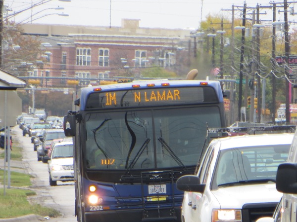
Heavy peak-hour traffic on North Lamar. Guadalupe-Lamar is Austin’s most heavily travelled inner-city central corridor, long seen as top priority for urban rail. Photo: L. Henry.
♦
For years, many Austin public transit activists have been insisting that the Guadalupe-Lamar corridor is the central inner city’s most heavily travelled local travel route, and should be the first priority for installing urban rail. In this blog’s first posting, in the spring of 2013, we described how City of Austin planners were proposing an urban rail starter line to connect downtown and the east side of the University of Texas with the Mueller development site, but “Lamar-Guadalupe is the ‘Missing Link’ in their plan.”
Ironically, COA has also been emphasizing that Lamar-Guadalupe is the primary local traffic corridor in central-city Austin, and even identified this corridor in the NEPA (National Environmental Policy Act) scoping meetings, held throughout Austin in spring 2012, as being at maximum capacity for over the past 2 decades.
In a posting just this past August, we summarized the case for Guadalupe-Lamar (G-L) in a single sentence:
Guadalupe-Lamar is the outstanding corridor to start urban rail — among the top heavy travel corridors in Texas, a long-established commercial district, with major activity centers, the city’s core neighborhoods, and the West Campus, having the 3rd-highest residential density in Texas.
By far, the heavy travel flow in this corridor one of that most compelling features that cry out for the capacity, public attractiveness, and cost-effectiveness of urban rail (light rail transit, LRT). Study after study has documented the fact that this is the most intensely traveled inner-city local corridor — the only major corridor serving the city’s central axis between I-35 and Loop 1 (MoPac).
Now, the latest annual report of the Texas Transportation Institute (TTI), endorsed by the Texas Department of Transportation (TxDOT) not only strongly corroborates these assessments, but provides data that further emphasize the key importance of the G-L corridor. The report tabulates both vehicular traffic (measured as daily vehicle-miles travelled, or VMT) and congestion (measured as annual person-hours of delay) for each major roadway included in the list.
TTI’s complete statewide listing of major roadways, in an Excel XLSX spreadsheet, can be downloaded from this link:
http://tti.tamu.edu/documents/umi/most-congested-in-texas-final.xlsx
Selected data from Austin (Travis County) is summarized (webpage text) at this link:
http://mobility.tamu.edu/most-congested-texas/austin/
Certainly, as north-south highways, I-35 and Loop 1 (MoPac) remain at the top of the list in terms of traffic flow and congestion (person-hours of delay). But these are primarily intercity-regional highways, flanked by frontage roads and sprawling, motor-vehicle-oriented development, mostly commercial. As potential transit corridors, they are physically inappropriate as alignments for regional passenger rail, and definitely unsuitable for urban-suburban light rail, which is ideal for interconnecting points along an inner-city corridor.
Guadalupe-Lamar is ideal for urban rail, since it channels incoming suburban travel from both I-35 and Loop 1 and distributes it to inner-city destinations. And it interconnects those same activity centers as well as many of Austin’s most established central-city neighborhoods.
The TTI data underscore the high-traffic primacy of Guadalupe-Lamar. Since these data a presented for segments of the total corridor, we’ve consolidated these segments to show flow in the entire corridor.
We’ve created graphic comparisons to contrast Guadalupe-Lamar with other major inner-city north-south corridors, both in terms of traffic flow (daily VMT) and congestion (annual person-hours of delay). Data for South Congress, South First, and Manchaca have similarly been consolidated to highlight each of these corridors in its entirety. (Data for South Lamar and Burnet Road were not similarly segmented in the TTI report.)
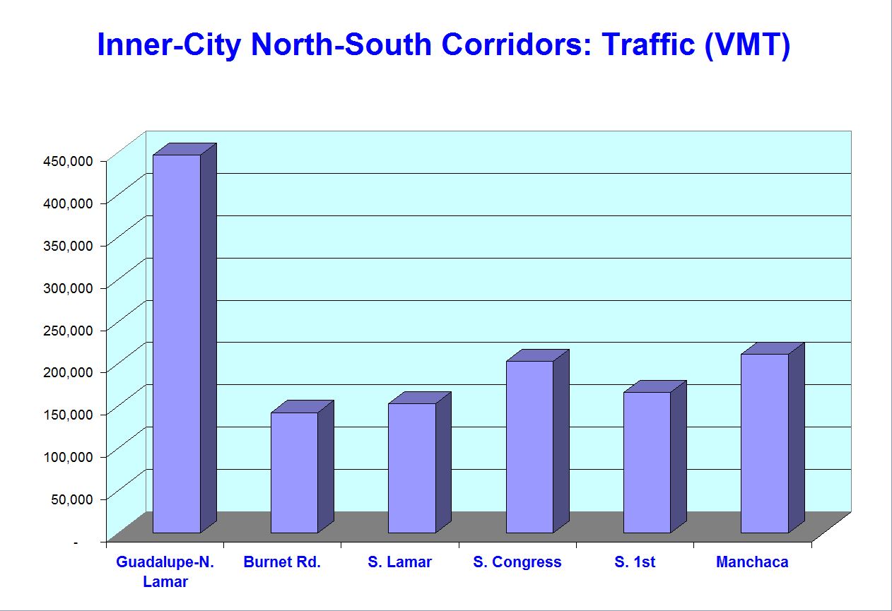
Graph illustrates that traffic flow in Guadalupe-Lamar is more than twice that of any other inner-city north-south corridor.
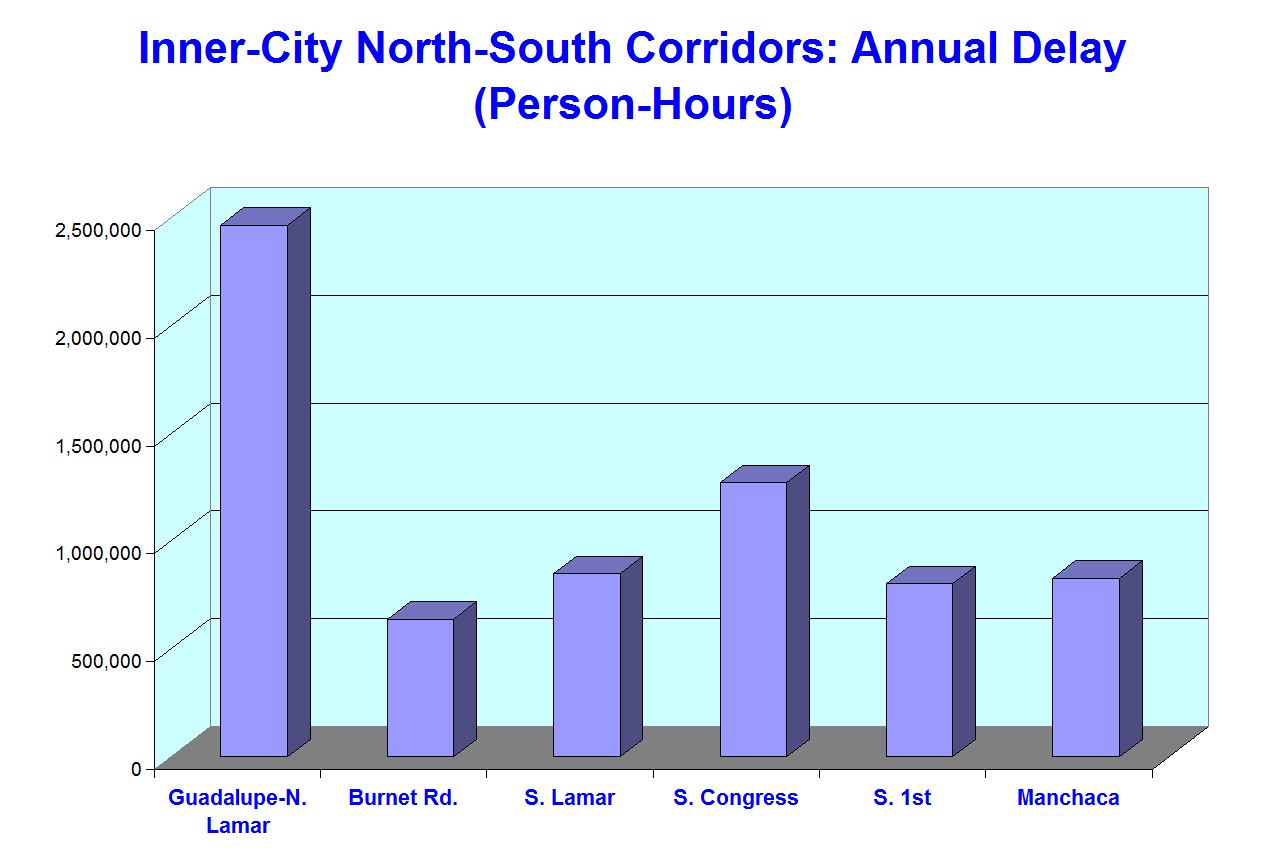
Graph illustrates that congestion (person-hours of delay) in Guadalupe-Lamar is nearly twice that of the next highest inner-city north-south corridor, South Congress.
We also compared the Guadalupe-Lamar data with TTI data for the officially proposed Highland-Riverside (H-R) urban rail route. H-R data were consolidated from available arterial data provided in the TTI report, which included the entire Riverside Drive alignment from South Lamar to S.H. 71, plus Airport Blvd. from North Lamar to I-35. (Other arterials in the Highland-Riverside route, such as Trinity, San Jacinto, and Red River, apparently register too little traffic and congestion to even qualify for inclusion on TTI’s listing.)

Graph illustrates that traffic flow in Guadalupe-Lamar is at a volume about 2.4 times that of arterials in the Highland-Riverside route.
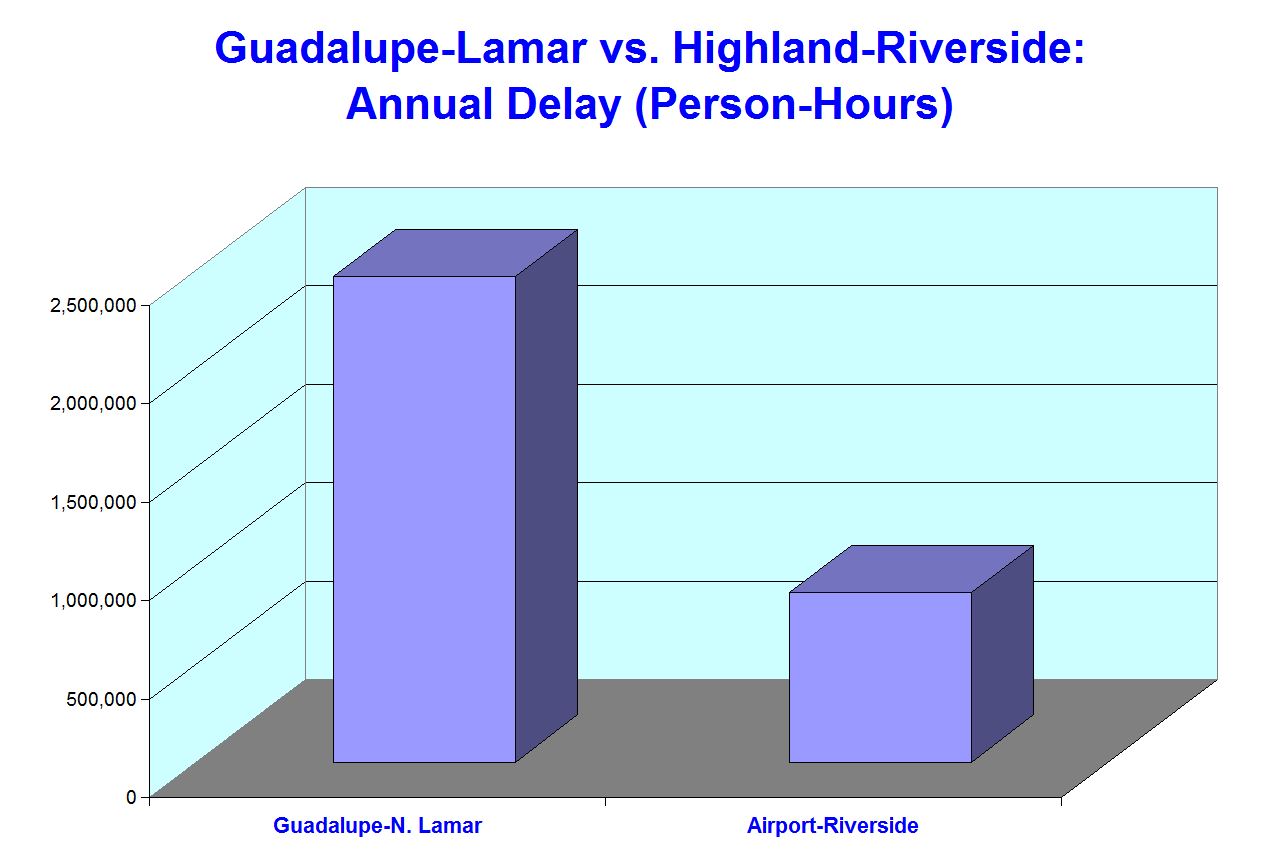
Graph illustrates that congestion (person-hours of delay) in Guadalupe-Lamar is nearly three times that of arterials in the Highland-Riverside route.
This comparison suggests that, in terms of both traffic flow and congestion (which can be interpreted as a proxy for travel density), the Guadalupe-Lamar corridor far outpaces the H-R corridor proposed for urban rail by Project Connect, and offered for public endorsement (i.e., bond funding authorization) in Proposition 1 on November 4th. (It’s worth noting that Project Connect’s much-vaunted “scientific” and “data-based” exercise a year ago, portrayed as a “study”, failed to evaluate a single actual travel corridor, let alone with this kind of data comparison.)
The logical conclusion: Overwhelmingly, in both traffic and mobility congestion, Guadalupe-Lamar trumps not only the official Highland-Riverside line, but every other alternative corridor as well. Good sense suggests that Guadalupe-Lamar remains the top-priority corridor for an urban rail starter line. ■

