Archive for the ‘Project Connect urban rail plan’ Category

h1

Downtown Austin’s Coming Light Rail Service Needs Republic Square Station

23 April 2024
Republic Square station would provide southwest sector of downtown 4-5 minute connectivity to light rail as illustrated by red lines. Graphic: ARN, adapted from original DAA map.

By Lyndon Henry, Editor

Why are urban rail stations in downtowns – central business districts (CBDs) – typically spaced so much more closely than in outlying stretches of rail lines? Of course, one major reason is that more frequent stations are needed to serve the density of these highly compacted activity concentrations – employment density in particular, although population density in city centers, like Austin’s, has also been increasing.

Commuters to downtown jobs will tolerate a longer walk to an outlying light rail transit (LRT) station, or even access of a mile or more to a park & ride. But over a century of experience has shown that most people don’t want to spend much above about five minutes walking to their workplace from their transit stop. Or from their workplace to the nearest transit station, to commute home at the end of a day’s work.

To some extent, in Austin Rail Now’s previous post, these factors are reflected in the map-graphic shown (originally prepared by the Downtown Austin Alliance (DAA) and included in a public document by the Austin Transit Partnership). Using shaded circular areas around several proposed downtown LRT stations, the graphic illustrates a quarter-mile/five-minute walk distance around each station. While the DAA’s graphic bolsters the case for adding a Wooldridge Square station to the LRT plan (an addition we strongly support), it also exposes a large gap in coverage for the southwest segment of downtown.

Republic Square station fills need

This gap can be filled by a Republic Square station (between W. 4th and 5th Streets), as shown in the graphic above (at the head of this article), which we’ve adapted from the DAA map. On our graphic, red lines radiating westward from the proposed station indicate approximate 4 to 5-minute walk distances to points in this area. Southwest downtown includes such major sites as the Federal Courthouse, the Seaholm development (with various shops and restaurants), the Austin Central Library, and several large condo and apartment highrises. The district also includes a multitude of other establishments, such as smaller shops, hotels, restaurants, and more. A Republic Square LRT station would also be just six blocks from the major westside Whole Foods Market.

The need for another downtown station (in addition to stations already proposed by the Project Connect team and the DAA’s Wooldridge Square concept) is highlighted in the following graph comparison of station spacing.  This uses roughly equivalent block lengths in several peer cities (considered quite successful in the industry); the data used for Austin includes the proposed Wooldridge Square station, which Project Connect considers an “option”. This comparison suggests that the downtown station spacing so far proposed for Austin’s coming LRT system seems inconsistent with Best Practices by these typical peer systems.

Even with “optional” Wooldridge station, proposed spacing of Austin’s downtown LRT stops appears to violate Best Practices of several peer city systems. Graphic: ARN.

Easy Interface with current transit hub

In addition to ease of access, another factor typically involved in the layout and spacing of downtown stations is the need to minimize peak crowding and to avoid overcrowding at any station in these high-population areas. Providing too few stations in these situations (which may be indicated by longer stop-spacing) can create excessive crowding that is unpleasant, dangerous, and disruptive to smooth operation and service.

And in regard to the proposed Republic Square station specifically, there’s another major consideration: the opportunity for LRT to interface with the major bus transit hub at Republic Square, which has functioned for years to provide a relatively smooth interface among routes, well-known to the public.

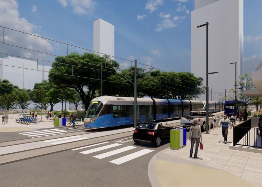
In artistic simulation, a light rail train rolls through Republic Square – but without a station! Graphic: Austin Transit Partnership.

Not only is the Republic Square hub well-established and familiar to the transit-riding community, it’s positioned  six blocks (along 4th St.) from the downtown MetroRail station at the Austin Convention Center, providing a feasible interconnection between MetroRail and the large assortment of bus routes converging at Republic Square. Adding an LRT station here would expand Republic Square’s role into a multi-modal transit hub.

For multiple reasons, a Republic Square station would fill a critical need and eliminate the remaining serious gap in the proposed downtown LRT alignment. But if this gap were to remain in the final plan, we can’t help imagining whether future generations of Austinites will be wondering: “What were they thinking?” And it’s critical to keep in mind here that retrofitting an urban rail station into an existing alignment – particularly in an intensively developed central-city environment – is far more expensive than including it in the original construction project. ■

h1

Downtown Light Rail Plan Needs More Stations

18 December 2023
Simulation of LRT train on Guadalupe St. at Republic Square from Project Connect’s revised plan. But so far, the plan does not actually include a station at this crucial downtown transit hub! Source: ATP

By Lyndon Henry, Editor

Austin’s light rail transit (LRT) project continues to progress despite difficulties. The Austin Transit Partnership (ATP) and Project Connect (PC) planning team have so far been able to overcome serious legislative and litigational threats from public transport opponents. Equally important, they’ve managed to navigate through serious budget problems arising from design complications, external economic inflation, and other factors.

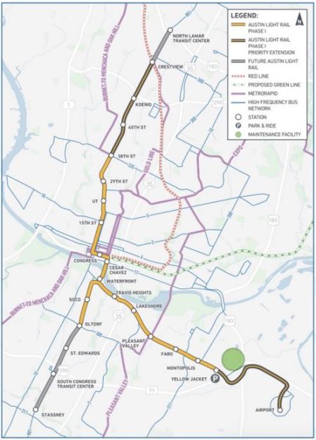
It’s a relief at last to have the workable (and hopefully entirely affordable) 3-branch light rail transit (LRT) system plan that ATP has adopted, shown in this map, publicly released this past May, which indicates proposed station locations as well as planned future line extensions:

ATP’s proposed Phase 1 surface LRT plan. Source: ATP

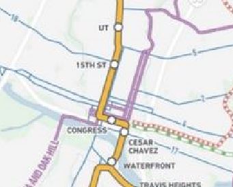
The revised downtown route is a surface alignment following several streets: Trinity St., 3rd St., and Guadalupe St. However, in discussions this past spring and summer with ATP staff and technical advisory committee members, I called attention to a major concern with respect to the small number of stations – just three – to serve both Downtown and the Capitol Complex – i.e., two-thirds of Austin’s critically important Central Area. All three proposed station locations – Cesar Chavez, Congress, and 15th St. – can be seen on this closeup from the map:

Closeup of LRT map with proposed downtown stations (Cesar Chavez, Congress, 15th St,)

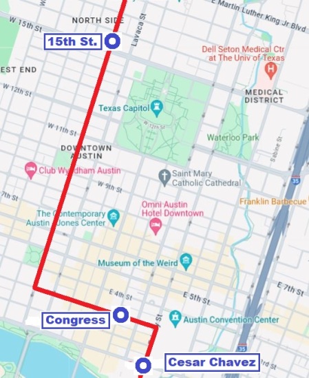
This deficit in stations results in a serious problem of inadequate station spacing in this key activity center complex. In particular, there is a 14-block gap (in line length) between the proposed Congress station (located on 3rd St. west of Congress Ave.) and the proposed 15th St. station (on Guadalupe). The route distance (per Google Maps) for this gap between these two stations measures 5,633 feet. That’s 1.1 mile, or 1,717 meters, between these stations.

The following more detailed map graphic, created from Google Maps, facilitates a more accurate assessment of the proposed LRT route and stations within the grid of streets, blocks, and major landmarks, and a better visual sense of the lack of stations along Guadalupe St., resulting in the sizable gap between the proposed Congress and 15th St. stations.

ATP’s proposed downtown LRT route and stations. Source: LH, via Google Maps

This is an exceptionally long spacing between stations for a major dense central area, and it appears to be inconsistent with Best Practices as exhibited by downtown route configurations in peer cities, particularly with central-city surface alignments, such those in as Portland, San Diego, Sacramento, Phoenix, Minneapolis, Dallas, Houston, Denver, Salt Lake City, and others, where spacing typically ranges from 3 to 8 blocks. In fact, I can’t immediately think of any other light rail system in North America with a station spacing that wide in the heart of its downtown.

Transportation consultant Jarrett Walker has discussed the stop-spacing issue on his website, HumanTransit.org: Basics: The Spacing of Stops and Stations.  As Walker notes, “… transit planners generally observe that the walking distance that most people seem to tolerate — the one beyond which ridership falls off drastically —  is about 400m (around 1/4 mi) for a local-stop service, and about 1000m (around 3/5 mi) for a very fast, frequent, and reliable rapid transit service.”

Here, Walker is discussing stop-spacing for a city as a whole. However, it’s crucial to consider the particular factors in play regarding the spacing of stations and adequate access in a downtown or other densely concentrated high-activity area. Given the dense mesh of downtown street structure, a circular radius yardstick doesn’t seem adequately applicable – transit users can’t walk in straight-line radii between worksites and transit stations, they must follow the zig-zag street configuration, which significantly increases total access distance. Plus additional time spent waiting at traffic lights must be taken into account.

Real access time in minutes would probably be a better comparative measure of ease of access. And it’s not just a matter of convenience. This means that excessively wide station spacing in a downtown may impair access, discourage use of the transit service, and thus significantly reduce ridership. It also imposes extra difficulty for the elderly and mobility-challenged. Potentially the problem could also damage public goodwill.

While the Project Connect team has expressed concern about steep gradients on Guadalupe at 5th St. and several blocks north that affect station construction, I note that industry guidelines are not rigid but do allow design to follow existing street gradients where this can be done consistently with safety and Best Practices. (Reference: TCRP Report 155, 2nd Ed. 201; U.S. Access Board, Accessibility Standards.)

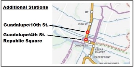
Taking into account these considerations, to remedy this (so far publicly presented) 1.1-mile gap in downtown LRT station spacing, on 28 April I proposed that at least two additional downtown stations on Guadalupe St. be added to ATP’s revised surface LRT plan. As illustrated in the small amended map segment presented below, these include a station at 4th/Guadalupe to serve the existing transit hub at Republic Square and the lower west side of downtown, as well as a station at 10th/Guadalupe, intended to improve accessibility to the north end and upper west side of downtown, including the Travis County Courthouse, many legal and professional offices, and the Austin History Center.

Proposed additional downtown stations. Source: LH

ATP personnel indicated that they were considering these proposals, and the broader possibility of adding more downtown stations to the revised LRT plan. So far, no changes have been publicized. ■

h1

Proposed Cost-Saving Light Rail Design Changes: Downtown and South Congress Avenue

20 November 2022

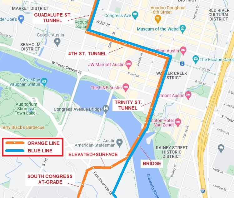
Proposed alternative Orange Line alignment. Source: L. Henry (click on graphic to enlarge).

By Lyndon Henry

Lyndon Henry, an urban and transportation planner, is a technical consultant to the Light Rail Now Project of Texas Association for Public Transportation (a Texas nonprofit organization) and contributing editor to Austin Rail Now (ARN). He is also a member of the Engineering, Architecture and Construction (EAC) Advisory Committee of the Austin Transit Partnership (ATP), the public agency overseeing Austin’s major transit development program (including light rail) approved by city voters in November 2020.
In April 2022, Project Connect reported it was encountering a $4.5 billion budget overrun in its light rail transit (LRT) program, of which $3.9 billion was linked to the Orange Line and tunnel segments. In a May2022 memo to the EAC committee, Lyndon noted that much of this “appears to be a result of the extension of the subway tunnel under the river, the South Bank, and South Congress Avenue” (which had replaced an earlier conception of a surface alignment and bridge). As remedial measures, Lyndon offered proposals to consolidate the Orange and Blue lines into a single tunnel alignment through downtown and onto a single crossing, by bridge, over the Colorado River (Lady Bird Lake). These ideas are being considered by the Project Connect team as possible design alternatives.
In an effort to contribute to the “criteria evaluation and project optimization” goals of a 22 October Light Rail Workshop of several ATP advisory groups, including the EAC, Lyndon submitted a handout proposing his tunnel and bridge consolidation plan plus suggesting a redesign of the South Congress light rail extension as a surface alignment, “avoiding the heavy cost of a subway tunnel in this segment.” These ideas “appear to offer potential to reduce cost and speed up construction, helping to fulfill what voters have approved” he noted, adding that “Hopefully, at least a portion of the proposed extension into Central South Austin might be completed per the original schedule.” The below presents the proposals in that workshop handout.

With serious potential budget overruns posed by the transit system plan designs to date, the Project Connect team has been seeking ideas for alterations and alternatives. Here are some of my own thoughts and proposals toward “criteria evaluation and project optimization” as requested in this workshop.

Securing public trust

A major premise of my approach, based on 50 years of involvement and research in public transportation, is that maintaining public trust is absolutely crucial to a project of this importance and magnitude.

Public expectations should be highly valued. Accordingly, my proposals are intended to maintain as much of the original light rail transit (LRT) route structure and completion schedule as possible, remaining faithful to what voters have approved. Given the budget problems and constraints that have emerged, this seems to imply some major changes to plan configurations, particularly infrastructure design, to reduce budgetary investment cost and minimize construction time.

Downtown subway reconfiguration

In the map [shown above] (originally presented to the EAC Advisory Committee in May), I have proposed an alternative alignment for the Orange Line southward from Republic Square, eliminating the currently proposed tunnel under the river to the South Bank and into South Congress Avenue. Instead, from Republic Square southward the Orange Line would follow the Blue Line alignment via the 4th St. tunnel, then the Trinity tunnel. Emerging just north of the Colorado River, the Orange Line would then share the proposed bridge over to the South Bank.

On the South Bank, the Orange Line would branch westward via available real estate and Riverside Drive right-of-way over to South Congress Avenue (a station could be installed in this area to provide approximately 0.4-mile access to Auditorium Shores and the Long Center). Sharing the Blue Line alignment via 4th St./Trinity St. and the proposed transit bridge as an alternative connection from downtown to the South Bank would alone reduce investment cost significantly (perhaps by $1 billion or more). The Orange Line could then proceed into the South Congress corridor either in tunnel or as a surface alignment.

South Congress surface alignment

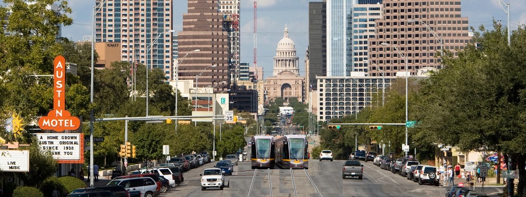
A surface alignment on South Congress Avenue (as proposed in the original conception of this LRT project) in lieu of tunnelling would offer another means of substantial construction cost and time saving and likely facilitate at least some of the previously proposed extension of the Orange Line into Central South Austin by 2029. Perhaps the widest local arterial in the central city, South Congress offers a virtually ideal opportunity for surface light rail. (See graphic simulation, below.)

Construction of surface facilities (e.g., stations, overhead contact system) should be possible within the Capitol View Corridors (CVC) regulatory guidelines at least as far south as Mary Street. (As defined by the Downtown Commission in a 2007 document, “A view corridor is a plane that extends from a defined view point or points to the base of the Capitol dome. … No structure is permitted to pierce the plane.”) To avoid obstructing the CVC in the remaining short segment from Mary to south of Live Oak St., trains could operate on batteries or perhaps a technology such as Alstom’s proprietary APS (alimentation par sol – ground power) electrification system, which uses a surface power strip between the rails which is electrified only when a train is passing on that section of track.


Simulation of surface light rail alignment on South Congress (courtesy George Barsky)

Rethinking intersection with Cesar Chavez St.

So far, design of LRT alignments downtown has been constrained by the assumption that Cesar Chavez St. with its heavy traffic flow cannot tolerate the interruptions from a surface intersection with light rail. However, LRT lines in various other cities have worked well for decades with surface intersections with similar major arterials (e.g., Portland’s original MAX LRT line has crossed the city’s major 5th and 6th Avenues downtown since 1986). Elimination of this constraint, thus permitting LRT surface crossings of Cesar Chavez, could provide Project Connect greater planning flexibility and lead to even more substantial cost savings. ■


h1

Plan now for conversion/inclusion of NW corridor, Red & Green Lines in CapMetro’s new light rail system

7 November 2021

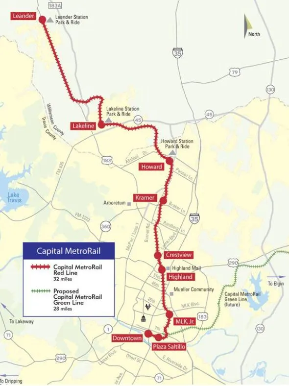
Red Line/NW corridor map
Map shows Red Line and proposed Green Line. Red Line north and west of Crestview station serves metro area’s northwest corridor, currently operated with diesel “urban commuter rail” technology. Conversion to electric light rail and inclusion in new LRT system would provide major advantages. Source: CMTA (click on graphic to enlarge).

By Lyndon Henry

Lyndon Henry, an urban and transportation planner, is a technical consultant to the Light Rail Now Project of Texas Association for Public Transportation and contributing editor to Austin Rail Now (ARN).

Capital Metro, Project Connect, and the Austin Transit Partnership seem to be heading toward a serious and expensive mistake, ultimately with longterm adverse consequences: setting in concrete and steel the exclusion of the metro area’s northwest corridor and Red Line from Austin’s new electric light rail transit (LRT) system. It’s a decision currently in planning and at “only” 15% of design, but the eventual results could include suppressing potential ridership, raising ongoing operating costs significantly, and locking in place a two-tier rail transit operation of two different technologies requiring separate but duplicative facilities to serve similar segments of the metro population.

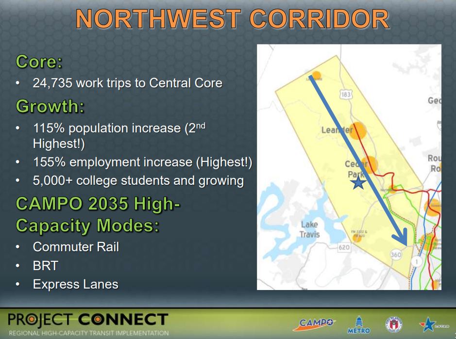
The northwest corridor – generally centered along the US 183 highway and 183A tollway, and also served by the Red Line “commuter rail” transit service to Leander – comprises metro Austin’s second-heaviest growth and travel corridor, after I-35. With density averaging more than 6100 persons per square mile, this corridor includes the City of Austin’s rapidly densifying northwestern suburban neighborhoods as well as the fast-growing suburban cities of Cedar Park and Leander. A member of Capital Metro’s service area since the agency’s inception, in 2020 Leander was described as an “Austin area suburb named as fastest growing city in America”. [Austin Business Journal, 26 July 2020]

“Urban commuter rail” substituted for light rail

From the 1970s, the railway line to Leander was envisioned as a crucial branch of a future LRT system, and as such was included in Capital Metro’s official light plans in the 1990s and early 2000s. However, to install a rail transit operation quickly, the MetroRail DMU (diesel multiple-unit) service, characterized as “urban commuter rail”, was conceived as an interim replacement, and approved by voters as part of the All Systems Go program in 2004.

At that time, the diesel-powered, bare-bones, lower-capacity, mostly single-track approach seemed an affordable, lower-risk way to get a minimalist rail transit operation up and running – in effect, a “demonstration line” allowing the metro Austin public to experience rail transit in their community, and to enable transit planners to assess community response. Unfortunately, current plans appear to perceive the “urban commuter rail” system – both the operating Red Line and new Green Line – as a permanently separate system, distinct from the electric LRT system now being implemented in central-city Austin.


Project Connect presentation in 2012 to Transit Working Group emphasized extraordinary demographic growth and ridership potential of northwest corridor. Source: Project Connect, TWG (click on graphic to enlarge).

Advantages of LRT for northwest corridor

Why is this such an unfortunate policy? Mainly because “commuter” rail (regional passenger rail) is a far less efficient and cost-effective mode than electric LRT for this kind of rapidly developing and densifying urban-suburban corridor. Here are some of LRT’s strongest advantages for Austin’s northwest corridor:

Faster, more frequent service — LRT’s high-power electric rolling stock, with higher acceleration/deceleration rates, would be able to provide faster, much more frequent service and thus substantially higher capacity for journeys within this major travel corridor to and from Austin’s central area.

Seamless connections — By interlining with the Orange and Blue LRT lines, LRT would offer a convenient, comfortable, “seamless” journey – without the need for a transfer – to northwest corridor passengers traveling to and from major destinations such as the University of Texas West Campus area, the Capitol Complex, the heart of downtown, and the ABIA aiport.

Significantly higher ridership — Faster, seamlessly direct rail transit service between the northwest corridor, the major activity centers within Austin’s core, and ABIA should itself stimulate a significant increase in ridership. The higher performance features of LRT could make additional stations in the corridor more feasible, adding a further boost in ridership.

Enhanced TOD potential — The availability of a fast, seamless, direct rail connection to Austin’s core and ABIA can be expected to further enhance the attraction of northwest corridor station sites for transit-oriented development (TOD). This in turn would likely create its own additional stimulus to ridership.

Lower operating costs — On average, the operating & maintenance (O&M) costs of LRT per passenger-mile (p-m) amount to just 34% of those of DMU “light commuter” operations of the same type as Capital Metro’s MetroRail. Put another way, MetroRail DMU operation costs about 3X as much per p-m as LRT. To take some examples from the most recent National Transit Database report (2019) by the Federal Transit Administration, Capital Metro’s Red Line service costs $1.73 per p-m compared to $0.85 for Dallas’s DART LRT system, $0.80 for Portland’s MAX, $0.39 for San Diego’s Trolley.

Elimination of duplicative service — Current planning seems to envision two permanently separate transit systems/technologies, with duplicate rolling-stock fleets, service facilities, etc., to serve corridors with basically very similar demographics within the same urbanized area. This seems inherently wasteful and unnecessary. Unifying these separate operations could further reduce costs by both eliminating duplication and facilitating economies of scale in procurements.

More flexible alignment opportunities — Unlike MetroRail’s “heavy” railroad rolling stock, LRT trains can turn street corners and run in city streets, as needed, compatibly with motor vehicle traffic. This would make possible, say, a simple crosstown rail transit connection between the Convention Center station and the Seaholm development area.

Compatibility with freight rail — Capital Metro’s privately contracted freight rail operation is currently an important revenue source for the agency; in addition, by reducing motor truck traffic on metro area roadways, it provides a net environmental benefit. MetroRail passenger service currently shares these tracks with freight via temporal (time) separation (freight operations run late at night, leaving the tracks free for transit service from morning to evening). LRT could operate likewise. LRT operations elsewhere also provide models and precedents for this: the San Diego Trolley (since 1981) and Salt Lake City Trax (since 1999) have successfully and safely shared tracks with freight railroad services for decades.


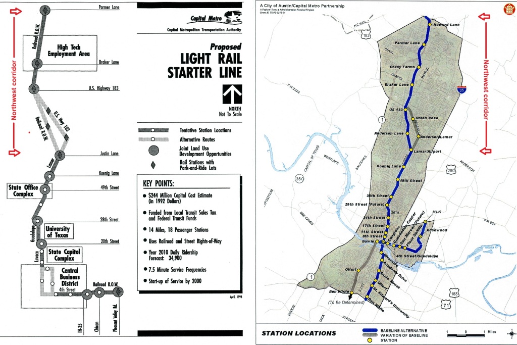
Service in northwest corridor (marked with red arrows on these maps) was proposed in past LRT plans developed by Capital Metro. LEFT: 1993 plan. RIGHT: 2000 plan. Source: CMTA (click on graphic to enlarge).

Unifying MetroRail and LRT

A unified system, with electric LRT service out to Leander, would not only serve one of the heaviest-traffic and fastest-growth corridors in the city with a proper high-capacity rapid transit-type operation, but would also, as noted above, enable an uninterrupted one-seat ride from Leander and other points along the Red Line corridor straight to UT, the Capitol Complex, and the heart of downtown. Making this a northwest extension of the planned Blue Line LRT would also incorporate a direct connection to ABIA. The Red Line service, from Leander to ACC’s Highland campus, through East Austin, and into the lower east side of downtown, could also be maintained with LRT.

Converting the MetroRail Red Line to electric LRT, and incorporating a connection in the grade-separation already being planned at Crestview, would be a relatively moderate-cost project, much less than building a new line from scratch. On average, using and modifying an existing railway alignment provide by far the lowest-cost type of LRT line construction. Planning for an integrated LRT system including the northwest line to Leander would need planning for both design and funding.

In terms of design, two engineering features are necessary:

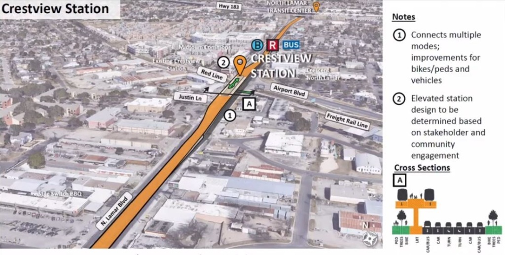
• Plans for the grade-separated interchange at Crestview (N. Lamar/Airport Blvd.) would need to be modified to include a future track junction to enable northwest-corridor trains to join and interline with the Orange/Blue Line tracks on North Lamar. As currently planned, both rail alignments would be separated from the North Lamar roadway lanes; but a total grade separation is also planned between the existing railway (Red Line, which would tunnel under the intersection), and Project Connect’s proposed LRT alignment (which would fly over the intersection on a viaduct). This would force a cumbersome transfer for all LRT passengers traveling to or from the northwest and points south. A track junction would facilitate interlining and enable the seamless, transfer-free ride described earlier.


Diagram illustrates current design (15% complete) of future Orange Line LRT entering elevated alignment on North Lamar at Crestview, with Red Line totally grade-separated and crossing below LRT in tunnel (freight track would remain at-grade). To link northwest corridor into LRT system, this design must be modified to include track junction between Red Line and Orange Line. Graphic: Project Connect (click to enlarge).

• LRT system rail and vehicle wheel profiles that conform with railroad specifications would need to be designed and selected (i.e., the rails and car wheel profiles for the new LRT system would need to match those currently in use for the Red Line). This is standard for transit systems that include track-sharing with heavy railroad operation.

However, it must be realized that Project Connect’s planners are moving quickly toward finalizing a two-tier separated MetroRail and LRT dichotomy permanently in their final design, now 15% completed in late 2021 and expected to be 30% completed in the spring of 2022. Unless that design is tweaked to include the unification and compatibility measures described in this report, residents in the northwest corridor, including Leander, would likely never have that one-seat ride to UT, the Capitol, and ABIA, and Capital Metro’s rail transit services would be burdened with higher-than-necessary O&M costs.

The inclusion of the northwest corridor, and conversion of the Red Line to LRT, are not part of the large Project Connect transit program approved by voters in November 2020 and now underway. These plan changes would need to be approved, funded, and undertaken as a future separate project. This would include negotiating for and receiving a track-sharing waiver from the Federal Railroad Administration (as was done in San Diego and Salt Lake City). But surely the multiple benefits and substantial cost savings justify investing the effort and resources to achieve a unified regional LRT system for metro Austin. ■

h1

Support Project Connect mass transit plan in this crisis? Definitely Yes

31 October 2020

Simulation of light rail train serving ABIA airport station. Source: Project Connect.


The $7.1 billion Project Connect mass transit plan – with two electric light rail lines, intersecting in a downtown subway, plus a network of vastly expanded and upgraded bus lines, running a new fleet of electric buses, and a new extension of the MetroRail diesel-powered light railway – is certainly Austin’s most ambitious mass transit plan to date, and possibly the most ambitious initial urban rail starter system yet proposed for any U.S. city. It represents the culmination of nearly 50 years of planning and intrepid effort by grassroots transit advocates, and unity between those who favored urban rail in an eastside-ABIA route and those favoring a central “spine” following the Guadalupe-Lamar and South Congress corridors.

To fund the local share of Project Connect, the City of Austin has placed Proposition A on the ballot, seeking voter approval of a substantial increase in the municipal property tax rate. City and Capital Metro (transit authority) leaders and planners expect federal funds to supplement nearly half of the investment cost of the plan.

Unfortunately, the Prop. A vote occurs as Austin, and of course the entire USA, writhes in the midst of a disastrous pandemic and concomitant deep economic and social crisis. Mass unemployment, widespread small business failures, rising evictions, foodbanks overwhelmed by mile-long queues of families – these are among the signals of massive distress, perhaps surpassing the Great Depression of the 1930s. Under these conditions, it’s understandable that even some otherwise firm, longtime supporters of public transport are hesitant or reluctant to embrace Prop. A and the tax measure

But in this very context of distress, now is precisely the crucial time to launch a massive public-works project like Project Connect to help resuscitate a semi-collapsed economy and provide a wide variety of new job opportunities. Furthermore, such an infusion of public funds will almost certainly have a multiplier effect – in particular, putting money in people’s pockets to support the many restaurants and other small businesses currently struggling to stay afloat.

While Prop. A would authorize a city tax rate increase averaging about 20%, that affects just a portion of total property taxes (Travis County, AISD, etc.); thus the total rate increase would amount to only about 4%. (See graph below.) Nevertheless, the hard reality is that, dollarwise, for most of us, this is a very hefty tax increase, averaging several hundred dollars for typical homeowners. In other words, in dollar terms the increase would be about as much as a typical monthly car payment.


Actual impact of property tax rate change would average about 4% increase in total taxes. Source: City of Austin.


But that that same ballpark amount for the “transit tax” would be an annual amount, not a monthly cost. In other words, the transit “payment” would be roughly 1/12 of the total annual payments on a typical car loan. (Of course, the car loan probably gets paid off in 4-5 years, but then at some point you’ve got to take out another one to replace your old car.)

So what do we get for the 1/12th of a car loan payment? With the major new flow of revenue, besides the new light rail lines (and subway) – including a rail connection to the ABIA airport – Capital Metro plans to increase frequency on virtually all bus routes, making them more accessible and feasible to use. There would be many more park & ride facilities to help with access to transit. Additional MetroRapid bus routes, with high-frequency service throughout the day, would be added and extended across the city.

By far one of the most useful innovations, especially for more outlying suburban areas and other neighborhoods with less access to fixed-route services, is the expansion of the “pickup-circulator” minibus/van system into 15 new zones – a system currently operating experimentally that functions somewhat like Uber/Lyft, but at far lower cost, to connect homes or other origins with major transit stops or other destinations. This service might not totally eliminate the need for a car, but it might reduce total driving (thus maintenance costs) and possibly eliminate the need for a second car in some households.

Certainly, this is a very difficult time for a big tax rate increase, and no matter when, it would be burdensome for most of us. However, let’s keep in mind that the rate hike would most likely begin with the 2021 assessment, probably becoming due sometime in early 2022. Hopefully we will all be climbing out of this disaster by then, and a major new Project Connect public works project would be injecting essential jobs and cash into the economy to help with the process of revitalization.

h1

Project Connect Plan Can Lead the Way Toward Regional Electric Light Rail System

30 September 2020

Austin metro area is a regional area and needs a complete, comprehensive, fully interlined regional electric light rail system for adequate, cost-effective mobility. Map: ARN, from Google Maps.

By Lyndon Henry

The following statement by Lyndon Henry, a technical consultant to the Light Rail Now Project and contributing editor to Austin Rail Now (ARN), was presented as part of Public Comment by phone on 7 August 2020 to a joint meeting of the Austin City Council and Capital Metro Board considering approval of an Interlocal Agreement and incorporation measure to implement a proposed Austin Transit Partnership to manage the proposed Capital Metro/Project Connect multi-modal transit system expansion project. The $7.1 billion multi-modal transit system plan, with two initial light rail lines, will be presented on the ballot for voter approval as Proposition A in the upcoming election on 3 November 2020. (The complete Project Connect long-range plan includes three eventual light rail lines as well as other regional rail services and various bus-based services.)

I’m Lyndon Henry. I’m an urban planner and transportation planning consultant, a former Capital Metro Board member, and a former data analyst for Capital Metro.

The Project Connect plan, centered on an urban rail system and anchored by a light rail spine along the key North Lamar-Guadalupe-South Congress Orange Line corridor, would basically implement the mass transit vision I’ve been advocating for the past 49 years. In pursuit of that vision, I participated in creating Capital Metro, served four years on its board, and later worked for the agency for nine years.

Starting in the 1970s, I initiated an effort to acquire, for rail transit use, the former Southern Pacific Railroad branch line from Giddings to Llano, the western part of which is in operation today as the Metrorail Red Line. I’ve also been continuously active over four decades as a community participant in the urban rail planning process, including Project Connect.

From its inception Capital Metro was conceived as a regional system with rail transit to serve both suburban and central-city neighborhoods of the Austin metro area. The Project Connect plan, with its three light rail lines, can be a major step toward fulfilment of that original intention to connect Austin’s more outlying neighborhoods with one another and the central city.

Expanding electric light rail is crucial to that regional vision. This can be done relatively easily and cost-effectively.

First, the Metrorail Red Line and proposed Green Line can be converted to faster, more cost-effective, high-capacity electric light rail service for the northwest and eastern sections of the metro area..

Second, the former Katy railroad right-of-way is a natural alignment to link eastern and northeastern suburbs and communities into central Austin.

Third, in south and southeast Austin, the former Bergstrom spur right-of-way offers an excellent route for an additional light rail line directly linking the ABIA airport with the Union Pacific rail corridor, South First St., the South Congress Transit Center, and neighborhoods east of I-35 along the Ben White/US 71 corridor.

I strongly support approving the Interlocal Agreement and incorporation measure to implement the proposed Austin Transit Partnership, and the funding commitments, toward the goal of building the regional highspeed electric light rail network that Austin has needed for so long.

h1

Project Connect’s Light Rail-Centered Plan Is a Huge Step Forward

31 August 2020

Simulation of Austin light rail alignment in roadway median. Graphic: Project Connect.

Commentary by Lyndon Henry


The following statement by Lyndon Henry, a technical consultant to the Light Rail Now Project and contributing editor to Austin Rail Now (ARN), was presented as part of Public Comment by phone to a joint meeting of the Austin City Council and Capital Metro Board on 10 June 2020. Subsequently, Project Connect’s plan for a $7.1 billion multi-modal transit system expansion, including two initial light rail lines, has been approved by the Austin City Council and scheduled as a ballot measure for the upcoming election on 3 November 2020.

I’m Lyndon Henry. I launched the concept of light rail transit for Austin with a feasibility study back in 1973. Over the past 47 years I’ve worked to make this crucial public transport system a reality.

As I’ve long pointed out, light rail has unique potential, as a more affordable high-capacity urban rail mode, to attract ridership, provide more cost-effective operation, stimulate transit-oriented development, galvanize the entire transit system, create a more livable urban environment, and mobilize community support.

At last, decades of effort by the City of Austin and Capital Metro, particularly Project Connect, have brought us to today’s monumental plan, centered on light rail with a central spine along the key North Lamar-Guadalupe-South Congress Orange Line corridor as its anchor.

This massive public-works project will provide jobs and help rebuild Austin’s economy when we finally emerge from the pandemic nightmare. Light rail will open exciting possibilities for catalyzing development in the Core Area, especially around the massive proposed subway infrastructure, as well as elsewhere along other corridors. This will provide crucial economic stimulus to create more jobs as well as expand critical taxbase and fund further service improvements.

Thinking well into the future has been a hallmark of Project Connect’s ambitious planning, preparing for future urban growth and transit capacity needs. This critical foresight must be continued with a view to eventual conversion of the Red Line to light rail transit.

The northwest corridor, paralleling US 183, definitely ranks among the heaviest travel corridors in our metro area. Converting the Red Line to more efficient electric light rail would provide huge service improvements, improve cost-effectiveness, and stimulate much higher ridership, especially by offering seamless, transfer-free travel from northwestern communities into Austin’s core. This would also extend electric light rail service to benefit East Austin neighborhoods.

This future improvement needs to be prepared for now, by designing appropriate infrastructure features into the planned Crestview intersection grade separation

I want to thank all of the diverse team involved with Project Connect for listening to so many of us in the community in developing this plan. It is certainly heartening and refreshing to see the results of this long saga of planning and to be able to support such an ambitious and exciting project.

I urge you to designate this plan as Austin’s Locally Preferred Alternative. Thank you.

h1

Project Connect study: Ridership potential, capacity advantages push light rail into lead

31 January 2020

Chart shows 2040 forecast ridership for both surface (top bar) and grade-separated (lower bar) options of BRT (left end of each bar) and LRT (right end of each bar). In both cases, LRT ridership substantially exceeds that of BRT. That disparity, plus capacity limitations of BRT, seem to tip scales toward LRT. Graphic: Project Connect (click to enlarge).

In what appears to be a dramatic turn in the saga of Austin’s Project Connect planning process, Austin civic leaders, Capital Metro’s Board, and the team of Project Connect (Capital Metro’s major transit investment planning program) appear to have embraced a planning scenario backing light rail transit (LRT) for both the Orange Line (North Lamar-Guadalupe-South Congress) and Blue Line (downtown-East Riverside-ABIA).

Consensus for this option seemed to emerge during and after a joint Austin City Council/Capital Metro Board work session on 14 January. According to a report in the Austin American Statesman of that date, while LRT would cost more to build than a bus rapid transit (BRT) alternative, “a Cap Metro analysis found the [BRT] system would reach its capacity in 2040.”

In comparison, rail would offer much more potential for passenger growth. Maximum capacity for ridership on a bus rapid transit system would be reached less than a decade from when the system is completed — a fact that doomed it as an option.

Bus rapid transit “does not work … and the analysis shows that now,” Council Member Jimmy Flannigan said. “It doesn’t have the capacity we need.”

Advocates for an LRT starter line serving the Orange Line corridor have long predicted the enormous ridership potential of this route, and Project Connect’s ridership forecasts, based on the Federal Transit Administration (FTA) STOPS model integrated with a locally developed model used by the Capital Area Metropolitan Planning Organization (CAMPO), bear out these community predictions. According to Project Connect’s working forecasts in their operations & maintenance documentation, LRT ridership is projected at unusually high levels for a single new starter line.

• For the year 2028, typical weekday ridership is projected at more than 54,200 for a 50% grade separated (elevated or subway) option, and over 47,200 for a 90% surface option.

• For the year 2040, typical ridership is projected at more than 73,500 for a 50% grade separated option, and over 61,600 for a 90% surface option.

The significance of these Orange Line ridership projections for a single starter line can be assessed by placing them in perspective with ridership experienced by the original single lines of other relatively new major rail rapid transit (RRT, “heavy rail”) and LRT projects, for which data has been readily available. (Weekday ridership data from National Transit Database and American Public Transportation Association.)

Light rail lines — Los Angeles (1993) 36,600; Denver (1996) 13,500; St. Louis (2005) 40,900; Dallas (1998) 36,700; Salt Lake City (2002) 31,400; Minneapolis (2005) 25,700; Houston (2005) 36,700

Rail rapid transit (“heavy rail”) lines — Philadelphia-Lindenwold (2019) 38,900; Miami (2019) 59,000; Baltimore 38,400.


For a single-line new-start project, projected 2040 ridership for Orange Line LRT alternative seems to exceed that of even several heavy metro lines, such as this one in Baltimore. Photo: Doug Grotjahn.


It can be seen that the Orange Line projected ridership, if achieved, would fall in the range of some of the highest-ridership new single lines, both LRT and RRT, in the USA, and possibly could count as the highest achieved by any new LRT project in this country.

As Project Connect’s planning proceeds further, attention is focusing on critical details, including fine-tuning and finalizing capital cost estimates that would impact a major municipal bond election proposed for this coming November. Current estimates for the complete Capital Metro service area system, including numerous additional corridors with lighter BRT operations, regional rail services, and other essential transit services as well as the LRT lines, range between $3.8 and $9.4 billion, depending on options such as percentage of surface alignment vs. proposed elevated or subway segments.

h1

Project Connect’s Orange Line operating cost assumptions seem to fail plausibility test

3 December 2019

Cover of Project Connect’s O&M cost methodology and assumptions report. Screen capture by ARN.


This analysis has been adapted and revised from comments originally posted to the #ATXTransit listserv by Lyndon Henry, a technical consultant to the Light Rail Now Project and contributing editor to Austin Rail Now (ARN).

For approximately the past year, Capital Metro’s planning program, Project Connect, has been analyzing two travel corridors for major high-capacity rapid transit investment – the Orange Line (basically following the North Lamar-Guadalupe-South Congress corridor) and the Blue Line (roughly following the Red River-San Jacinto/Trinity corridor through downtown and then the Riverside corridor out to ABIA). A federally required Alternatives Analysis has been undertaken by a consulting team led by AECOM to recommend a modal system choice between light rail transit (LRT) and bus rapid transit (BRT), as well as other features and service characteristics such as vehicle types, station locations, alignments, and the capital costs and operating and maintenance (O&M) costs of each alternative.

Recently the agency released as public information selected details, including methodological procedures and cost assumptions. These have prompted scrutiny by community professionals and activists, particularly in regard to important O&M cost assumptions. In some cases these assumptions have been called into question.

For example, a 13 November posting by research analyst Julio Gonzalez Altamirano (JGA) on his Informatx.org website presented an extensive critical analysis. This resulted in two major findings:

• Project Connect’s BRT revenue hour cost estimate is lower than the national average by 26%. Project Connect does not explain its rationale for the methodological choices that lead to the lower rate.

• Project Connect’s use of a flat passenger car revenue hour rate to calculate LRT costs obfuscates the economies of scale associated with multi-car LRT trains. This is a change from the approach taken by Project Connect in 2013-2014. The new method makes Blue Line LRT appear more productive and Orange Line LRT less productive than an approach that recognizes the cost advantages of LRT scale (e.g. multi-car trains). Project Connect does not explain the rationale for the methodological switch or why its current approach will generate more accurate estimates.

These findings are broadly in line with the results of ARN’s own research into Project Connect’s O&M cost methodology and resultant assumptions, particularly with respect to the Orange Line surface LRT and BRT alternatives. Our analysis relied primarily on data for appropriate peer systems to Austin, reported in the Federal Transit Administration’s National Transit Database (NTD).

Basically, we find that Project Connect’s cost per vehicle-hour assumptions consistently seem to overestimate LRT costs by more than 51% and underestimate BRT costs by over 26%. The bottom-line result is to skew Project Connect’s O&M cost assumptions as much as 70% in favor of the BRT alternative. This produces a relatively huge disparity in evaluating the alternatives, and challenges plausibility. Details of our analysis, plus conclusions and a recommendation, are presented below.

Methodology

Operational configurations and service cycles affect O&M costs, including costs per vehicle-mile. ARN’s methodology has differed somewhat from JGA’s. Most importantly, from the 2017 NTD (latest currently available), ARN selected seven new-start LRT “peer” systems based on both urban characteristics and surface-running alignment and operational configurations that we judged to more closely match those of Austin and the proposed Orange Line surface LRT: Denver, Houston, Minneapolis, Phoenix, Portland, Sacramento, Salt Lake City. Although some have urban or suburban branches on exclusive alignments, all have significant segments in urban streets.

These seven systems have been selected in part for their urban, extensively on-surface, and in some cases predominantly street-routed character (similar to the alignment proposed for Austin’s Orange Line). Generally comparable urban population and density were also an important factor. As state capitals, Denver, Sacramento, Phoenix, Salt Lake City, and St. Paul (included in the Minneapolis-St. Paul system) also make good peer cities for Austin. Other new-start LRT systems that might have some sections on city streets but operate predominantly over extensive regional lines or grade-separated alignments were not considered as fully comparable cost models.

In contrast to our peer-systems approach, Project Connect states that, via its own methodology, “O&M unit costs for LRT service reflect a weighted national average cost per revenue hour ….” [Orange Line Operating and Maintenance Costs, 30 Oct. 2019] Apparently these costs are based on NTD data.

However, if Project Connect calculated its average from national data of all LRT systems reported in the NTD, this would have included a widely disparate collection of O&M and other data, much of it starkly dissimilar to Austin’s demographics and proposed LRT operational conditions. For example, legacy systems (remnants of historic surface electric railways dating back to the late 19th or early 20th century) such as those in Boston, San Francisco, Newark, and Pittsburgh retain a variety of older operating characteristics (e.g., onboard fare collection by train operators) that drive their vehicle-hour costs significantly higher than the average of modern new-start systems.

Other problems with such an indiscriminate approach include differences in alignment engineering configuration. Accordingly, we assessed some modern new-start LRT systems to be less suitable O&M vehicle-hour cost models for Austin’s proposed street-routed LRT Orange Line, including several we excluded particularly because of their proportionately more extensive subway and elevated segments: Buffalo, Los Angeles, St. Louis, Dallas, Seattle.

Nevertheless, despite what appear to be serious weaknesses with its own methodological assumptions, Project Connect has calculated an O&M cost per vehicle-hour of $284.15 (2017) for its Orange Line LRT surface alternative.

As regards BRT, in our judgement eight of the operational configurations of BRT systems reported in the 2017 NTD seemed to conform to the Orange Line BRT surface operating proposal, and can be assumed to represent peer systems with respect to Austin. These BRT services – operating in Cleveland, Eugene, Ft. Collins, Grand Rapids, Hartford, Kansas City, Los Angeles, and Orlando – thus provide an appropriate basis for comparing and evaluating Project Connect’s Orange Line LRT and BRT scenarios. New York City was excluded because its exceptionally high density, population size, and vast multi-model transit system are far out of proportion to Austin’s conditions. Boston’s disconnected system, partly operating as a trolleybus subway, also seemed inappropriate as a peer system. Likewise the Roaring Fork Transportation Authority’s operation, a basically rural system more closely resembling a regional or intercity motor coach service than an urban transit service, was also excluded. Data for the eight peer systems were used to develop metrics for comparison with Project Connect’s assumed cost inputs.

For 2017 O&M cost per vehicle-hour for Project Connect’s Orange Line BRT surface alternative, Project Connect’s own assumptions (based on information from CMTA and NTD) amount to an effective estimate of $119.10, as JGA has converted from Project Connect’s 2028 estimates.

To calculate current national averages and metrics for comparison, we’ve totaled current costs and other relevant values for the target LRT and BRT peer groups from National Transit Database (NTD) profile data, then calculated averages from those totals. All costs discussed are presented in 2017 dollars.

Results

LRT: Average actual 2017 O&M cost per vehicle-hour for the seven peer LRT systems is $187.52, 34.0% lower than Project Connect’s assumed cost of $284.15 for the Orange Line surface LRT option.

BRT: Average actual 2017 O&M cost per vehicle hour for the eight peer BRT systems is $162.23, 36.2% higher than Project Connect’s assumed cost estimate of $119.10 for the Orange Line surface BRT option.

LRT vehicle-costs/hour are typically higher than for buses mainly because LRT cars are larger and stations are also usually larger, creating higher maintenance costs. (These characteristics generally stem from LRT’s higher capacity and propensity to attract greater passenger volumes.) The ratio of actual NTD-reported peer-system LRT to BRT costs is 1.16. However, Project Connect’s cost assumptions amount to an LRT:BRT ratio of 2.39 – in other words, approximately twice the cost ratio in actual operating experience. The disparity between Project Connect’s estimates and costs experienced in actual operations is illustrated in the graph below.


Graphic illustration of disparity between Project Connect’s O&M unit-cost estimates and actual reality of costs experienced by actual operations of comparable peer LRT and BRT systems. Graph: ARN. (Click to enlarge.)


Conclusions and recommendation

Project Connect’s assumption for cost per vehicle-hour appears to substantially underestimate BRT and overestimate LRT – and this has dramatic consequences for the agency’s overall cost model results, seemingly skewing the evaluatory process and calling into question the plausibility and validity of the agency’s O&M cost analysis. The table below, presenting Project Connect’s comprehensive O&M cost calculations for the Orange Line alternatives, illustrates how the differential in O&M cost-per-vehicle-hour estimates translate into enormous differences of tens of millions of dollars in annual O&M cost assumptions.


Table of O&M cost calculations from Project Connect’s report. Screen capture by ARN. (Click to enlarge.)


We would strongly recommend that these assumptions and the overall O&M analysis of these alternatives be reviewed and revised – particularly by basing cost estimates on appropriate peer systems relevant to the LRT and BRT alternatives proposed by Project Connect for the Orange Line.

h1

Austin Coalition for Transit supports light rail transit for proposed Orange Line

26 November 2019

ACT backs light rail for Orange Line. Graphics: ACT logo, Project Connect map.


The following is a media release issued by Austin Coalition for Transit (ACT) on 1 October 2019. Austin Rail Now, a participant in the ACT coalition, supports this policy statement. The statement has been slightly reformatted and edited for website publication.

Press Release:

Tuesday, October 1, 2019

Subject:

Austin Coalition for Transit (ACT) Issues Statement Supporting Light Rail for the Orange Line

Contact:

[Provides names and contact information for: Andrew Clements, Dave Dobbs, Roger Cauvin, Lyndon Henry, Steven Knapp, Roger Baker, Scott Morris, Gabriel Rojas, Mike Wong]

Today marks the one year anniversary of the release of the draft Project Connect Vision Map. It is an appropriate time to discuss some of the benefits an investment could bring to the people of our city and to the region as a whole.

Background

On October 1, 2018, a draft Project Connect Vision Map was released, and the Capital Metro Board went on to adopt an amended Project Connect Long-Term Vision Plan on December 17th. Two high capacity rapid transit corridors, the Orange Line and the Blue Line, were advanced for further study. A Federal Transit Administration (FTA) alternatives analysis has been underway to recommend modes or vehicle types, station locations, street alignments and service characteristics. Transit advocates have participated in this process, and we thank the agency for its public engagement.

Project Connect Orange Line: Unique Purpose and Potential

► The 21-mile Orange Line will be the north-south spine of Austin’s transit system. It will run in the Guadalupe-North Lamar and South Congress corridors between Tech Ridge and Southpark Meadows and may be served by an east-west grid of timed-transfer bus routes.

► The purpose of the Orange Line is to increase affordable, sustainable mobility and create economic opportunity for all, especially for the working class, people of color and the most economically vulnerable.

► The Orange Line will greatly increase the number of people who can move through the region’s core without the hindrance of congestion.

► The Orange Line will catalyze station-area economic development and include affordable housing developments for diverse economic groups to address the acute housing shortage in Austin for lower and middle-income families and individuals.

► Station-area development will also add to the commercial tax base, generating revenue for the City and Capital Metro that can be used to help pay for the costs to operate and maintain a Light Rail Transit system.

► As a successful starter line of a new transportation system, the Orange Line will improve daily life for a significant percentage of the region’s population and unify the city for generations to come.

Why Austin’s Orange Line Needs Light Rail

► The vehicle or mode of transit for this corridor has not yet been finalized, but strong current and future ridership demand in Austin’s most active transit corridor make Light Rail the most appropriate mode or vehicle choice.

► Light Rail offers large-vehicle capacity with speed to meet this ridership demand. The largest Bus Rapid Transit (BRT) vehicles are too small and slow and require wider lanes. The current 60’ MetroRapid BRT buses are overwhelmed by the number of riders even now.

► Orange Light Rail will attract more riders than buses, and use narrower lanes, maximizing the return on the public space required. Since 40% of Orange Line riders are expected to transfer from buses, this attraction factor will benefit the whole system.

► Orange Light Rail will have the capacity and frequency to move large volumes of people safely, reliably and comfortably within our constrained corridors.

► Orange Line Light Rail would serve the highest concentration of employers in the region and offer all people, including those who are economically disadvantaged, the ability to quickly get to well-paying jobs.

► Orange Line Light Rail will increase freedom and economic opportunity for students and the working class by reducing car dependency, maximizing the number of people who are able to live without the expense of a car.

► Orange Line Light Rail will maximize the ridership potential in the corridor, accelerate development of the transit system, and maximize the environmental benefits and human capital return on the investment.

Feasibility and Opportunity

► Orange Line Light Rail has the potential to pay for itself by delivering the highest return on investment (ROI) and will allow tax increment financing (TIF) in station areas to pay for the operation of the system. It will be a catalyst to invigorating and creating rail stations that are great urban places scaled to the pedestrian. Residential taxpayers will benefit from the new commercial tax base over time as a greater portion of city, county and school district property taxes will be covered by new commercial property in downtown and station areas.

► Orange Line Light Rail will efficiently scale to meet passenger growth, reducing Capital Metro’s per-passenger operating costs for each new rider as total system ridership grows over the years.

► Effective high capacity rapid transit requires dedicated transitways. The Orange Line is aligned with the Austin Strategic Mobility Plan (ASMP) allowing for dedicated transitways on Guadalupe, North Lamar and South Congress. This plan reduces car dependency, calling for a mode shift toward high capacity transit and active transportation. These goals will not be reached without good high capacity transit that people actually want to ride and adopt into their daily lives. Once dedicated transitways are built, it will be easier to find political support to retain and defend them with Light Rail than with buses.

► Outside the immediate Orange Line station areas, the City of Austin should consider developing transit-related land use policy to protect the vulnerable populations of North Lamar and South Congress by preserving their contributions and culture, reversing displacement and safeguarding existing affordable housing. Extending north of US 183 into the Rundberg area, the Orange Line will connect a dense and transit-dependent, multi-cultural population to work and play opportunities in other areas of the city.

► The 21-mile Orange Line runs parallel to IH-35 and Mopac and would serve as a bypass to help take pressure off highways by adding people-moving, time-certain mobility capacity for our growing region. Tech Ridge and Southpark Meadows are ideal transfer points for regional commuter buses, large park and rides or sites for affordable housing. Combined with the Red Line connection at Crestview, the Orange Line will give Central Texas commuters real alternatives to IH-35, Mopac and Hwy 183 congestion.

► Linking the neighborhood, town, and regional centers along the Orange Line will serve to activate the vision of the Imagine Austin centers concept by providing necessary transportation infrastructure for these locations.

► The Orange Line should be largely built on the surface to improve station access, maintain cost effectiveness, and keep the project affordable for the taxpayers of the City of Austin. Expensive underground tunneling and elevated segments must be minimized to keep the project competitive for federal capital grant funding.

► On narrow streets, other cities have met this challenge and avoided expensive tunneling or elevation by routing one direction of track down a parallel street, removing the center catenary pole, using curbside stations or purchasing right of way.

► The Orange Line and Blue Line need an interconnection that would allow riders to change lines seamlessly. Both the lines need to share at least one common station. The connector on 4th Street proposed by Project Connect between the Convention Center and Republic Square effectively splits the Blue Line in two. Blue Line passengers need a direct way to access Republic Square. It’s the city’s busiest transfer center and major point of convergence of express, local and MetroRapid buses, as well as a potential interconnection to the Orange Line.

About the Austin Coalition for Transit

Rooted in decades of advocacy, ACT is a coalition of individuals and non-profit organizations. ACT works collaboratively and inclusively to conduct a nonpartisan, equity-based, politically honest and technically accurate discussion about transit and its interrelated policy areas. ACT is independent of any agency or governmental body, and it works to ensure the voice of transit users are heard in transit planning.

Follow the Austin Coalition for Transit on Twitter for updates: @AustinTransit

h1

Project Connect Orange Line: Unique Purpose and Potential

26 October 2019

Project Connect’s Vision Plan map shows proposed Orange Line alignment from Tech Ridge (north) to Slaughter Lane (south). Annotated by ARN.


Commentary by Dave Dobbs

The following summary proposing urban rail for Austin’s Orange Line corridor is adapted and edited from a previous Email commentary by Dave Dobbs, Executive Director of Texas Association for Public Transportation and publisher of LightRailNow.com.

Running in the Guadalupe-North Lamar and South Congress corridors between Tech Ridge and Southpark Meadows (see map at top of post), the 21-mile Orange Line will be Austin’s north-south electric urban rail transit spine. It must be fed by an east-west grid of timed-transfer buses that will provide a viable alternative to the private automobile, thereby increasing affordable, sustainable mobility for all, regardless of income or circumstance.

Regionally, large park & ride facilities at the ends of this “anchor” line, and rail connections at Crestview, will give Central Texas commuters real alternatives to the congestion on IH35, MoPac (Loop 1), and US183, thereby insuring high daily ridership on both trains and buses. Catalyzing station-area economic development will follow, with “alternative downtowns” and dense, mixed-use housing opportunities for a wide range of incomes and for a far larger number of Austin’s citizens – thus providing affordable living space to address the acute housing shortage in Austin for lower and middle-income families.

Every Austin taxpayer, transit rider or not, will benefit from the large commercial tax base created. Revenues from property and sales taxes uniquely generated by the Orange Line urban rail investment will more than pay for the capital and operating and maintenance (O&M) costs of the urban rail itself as shown by the experience of a number of new U.S. light rail transit systems installed since 2001. Examples of cities where documentation is available of these catalytic, massive urban rail economic development effects include: Portland, Dallas, Salt Lake City, Phoenix, Minneapolis/St. Paul, Houston, and Kansas City. (Also see: Methodological Considerations in Assessing the Urban Economic and Land-Use Impacts of Light Rail Development.)

h1

An Alternative Basic Urban Rail Framework for Austin

29 September 2019

Basic Urban Rail Framework, using available “opportunity assets”, is readily implementable, affordable path to a more extensive, interoperable citywide urban rail system using electric light rail transit (LRT) technology. Map: ARN. (Click on image to enlarge.)

This proposed alternative vision for a “foundation” of Austin-area urban rail lines has been revised and updated from a handout originally distributed on 21 August 2019 to a Project Connect community meeting.

An extensive high-capacity urban rail system, together with high-quality bus services and other useful public transport modes, would be a transformational upgrade of mobility for metro Austin and its surrounding region. Towards this goal, the lines in the map above represent a proposed initial “skeleton” or framework of readily implementable, affordable, workable urban rail alignments, upon which routes/branches into other corridors can be added.

The key advantage of this Basic Urban Rail Framework is that these alignments are, in effect, the “low-hanging fruit” of available “opportunity assets” – in this case, available railway alignments and wide roadways – that can expedite implementation of multiple interoperable urban rail lines, deploying electric light rail transit (LRT) technology, providing exceptionally attractive, cost-effective, high-capacity rail transit. Using the technologically common mode of LRT, interconnected urban rail lines (and rolling stock) can be interlined (shared by different routes).

Given Austin’s size, growth dynamics, and financial resources, LRT is optimally scaled to achieve the essential and realistic mobility goals for our metro area. LRT makes the best use of existing “opportunity assets”, particularly available railway alignments. Both the existing Red Line and proposed Green Line (both using CMTA-owned right-of-way) can be upgraded to LRT at approximately half the cost (or less) per mile of new street trackage. In fact, much of the existing trackage and other infrastructure of the Red Line can be converted to LRT at even lower expense.

Capacity and high acceleration capability are critical. LRT would provide adequately high capacity and performance to attract and cost-effectively accommodate heavy ridership volumes (current and future), particularly in the northwest Red Line corridor. More efficient performance, higher capacity, and lower unit operating & maintenance costs would be expected from conversion of the Red Line from diesel multiple units (DMUs) to electrically propelled LRT. Not only would an LRT Red Line enable urban rail service into northwest Austin, but in addition it would provide significantly higher-level urban rail service to East Austin and interconnective links to work, education, and other opportunities.

Freight service could be maintained on both the Red Line and Green Line tracks via a Federal Railroad Administration shared-use waiver based on temporal separation (logically, meaning late-night use of these tracks only by freight trains). The outer segment of the Green Line to Elgin (and other regional extensions) could possibly be served with DMU regional rail using existing rolling stock.

A complete transit network of local routes, “rapid bus”, express bus, etc. can be overlaid on this Basic Framework of primary LRT trunk lines. Additional urban rail lines (possibly as streetcar operations) could branch from these trunk routes to serve other corridors; for example: Manor Road to the Mueller development and northeast Austin; MLK into East Austin; and the Lake Austin Blvd. corridor serving the south segment of West Austin.

LRT systems have demonstrated an exceptional ability to attract new riders, and to catalyze economic development and transit-oriented-development (TOD). Additional taxbase created often can more than recompense the costs of LRT systems. Those are additional reasons why this Basic Urban Rail Framework makes abundant sense.

h1

Blue Line Should Branch from Orange Line Urban Rail — Nix the Redundant Infrastructure!

15 August 2019

Map shows ARN’s alternative proposed urban rail configuration in Core Area connecting Orange Line (Tech Ridge to Slaughter Lane) with Blue Line (UT campus through Core Area and East Riverside to ABIA). Both lines would share First St. (Drake) Bridge over river, thus eliminating need for an expensive redundant Blue Line bridge. Blue Line would branch from Orange Line at Dean Keaton and at W. 4th St. to serve east side of Core Area and provide link to airport. Map: ARN.
(Click image to enlarge)


By Austin Rail Now

Commentary slightly adapted from one-page handout originally produced by ARN and distributed to participants in Project Connect’s Blue Line Workshop at ACC Highland, 31 July 2019.

► Orange Line as primary corridor — Urban rail installation in the Orange Line alignment (N. Lamar-Guadalupe-Lamar-South Congress/NL-G-SC) must be prioritized. Positioned as Austin’s major central local corridor, between I-35 to the east and Loop 1 (MoPac) to the west, the Orange Line corridor is the center city’s 3rd-heaviest north-south travel corridor (after I-35 and MoPac). The City of Austin has repeatedly emphasized that this is the primary local traffic corridor in central-city Austin, with exceptionally heavy traffic at maximum capacity for over the past 2 decades. North Lamar alone is ranked by Texas Transportation Institute as one of the most congested arterials in Texas. With Austin’s highest total employment density on Guadalupe-Lamar, an urban rail line there alone could serve 31% of all Austin jobs. It would also serve the highest-density residential concentrations in the city — including the West Campus, ranking the 3rd-highest in residential neighborhood density among major Texas cities.
https://austinrailnow.com/2014/10/13/latest-tti-data-confirm-guadalupe-lamar-is-central-local-arterial-corridor-with-heaviest-travel/
http://centralaustincdc.org/transportation/austin_urban_rail.htm
https://austinrailnow.com/2019/07/29/future-proof-austins-mobility-with-urban-rail-not-infrastructure-for-techno-fantasies/

► Light rail transit (LRT) — For over 30 years, urban rail in the NL-G-SC (currently designated Orange Line) alignment has been regarded as the key central spine for an eventual citywide and regional urban rail network using well-proven, widely deployed, effective, affordable light rail transit (LRT) technology. Particularly with little to no need for major civil works, the Orange Line is ideal for a surface-installed LRT starter line.

Since initially selected as Capital Metro’s Locally Preferred Alternative in 1989, LRT has remained Austin’s premier major high-capacity transit vision. LRT has demonstrated numerous key advantages over bus rapid transit (BRT). And unlike many “gadget” alternatives, LRT is well-proven in service, a readily available technology, and non-proprietary. (In contrast, “autonomous BRT” has been neither deployed commercially nor even tested.) Compared with buses, LRT systems provide higher capacity and are faster, more user-friendly and more comfortable to access and ride. On average, ridership on new LRT systems is 127% higher than on BRT. LRT is also more cost-effective – average operating cost of new LRT systems is 10% lower than for BRT.
http://www.lightrailnow.org/industry_issues.htm#ridership
http://www.lightrailnow.org/industry_issues.htm#mode-preference
http://www.vtpi.org/bus_rail.pdfAPTA/National Transit Database

► Alternate Blue Line — Simply trying to resurrect the failed 2014 Highland-Riverside plan is not a prudent option. The Blue Line makes the most sense if it shares segments of the Orange Line, branching from it to serve the eastside of the Core Area and UT, and the East Riverside corridor (and ultimately ABIA). Running westward from ABIA on East Riverside, the Blue Line in this proposal would join the Orange Line south of the S.1st St. (Drake) Bridge. Sharing trackage across the bridge, it would proceed northward to Republic Square, where it would turn east to the San Jacinto/Trinity arterial pair, then turn northward and proceed to serve the Medical District and the UT East Campus. At Dean Keaton, the alignment would then turn west and travel on Dean Keaton toward Guadalupe St. to rejoin the Orange Line, proceeding northward from there. Access to-from ACC Highland could be made available via transfer with Red Line trains (with improved frequency) or various bus alternatives (from UT campus or Crestview).

► Eliminate redundant infrastructure — Major advantages of this alternative include more efficient operation, better passenger interconnection between Blue and Orange Lines, and very significant cost savings through eliminating redundancy: the proposed bridge over the Colorado, approximately three miles of line infrastructure paralleling the Orange Line, and five stations.

h1

“Future-Proof” Austin’s Mobility With Urban Rail — Not Infrastructure for Techno-Fantasies

29 July 2019

Orange Line (north-south route indicated within black outline) shown within Project Connect’s map of proposed regional system. Excerpted and edited by ARN.


By Austin Rail Now

Commentary originally produced by ARN and distributed (as one-page handout) to participants in Project Connect’s Orange Line Workshop at Austin Central Library, 17 July 2019.

♦ Light rail transit (LRT) — This well-proven, widely deployed, effective, affordable urban rail alternative has been proposed for the Orange Line (N. Lamar-Guadalupe-S. Congress) corridor for 30 years. Since selected as Capital Metro’s Locally Preferred Alternative in 1989, LRT has remained Austin’s premier major high-capacity transit vision. In early 2018, Project Connect 2’s proposal for LRT in the Orange Line corridor received widespread community acclaim. However, the proposal was subsequently quashed by Capital Metro, which proceeded to restart the Project Connect process.

As noted below, LRT has demonstrated numerous key advantages over bus rapid transit (BRT). And unlike many “gadget” alternatives, LRT is well-proven in public service, a readily available technology, and non-proprietary. (In contrast, “autonomous BRT” has been neither deployed commercially nor even tested.)

♦ Ridership — On average, light rail systems have excelled in attracting passengers, especially new riders who have access to a car but choose to ride LRT. Compared with buses, LRT systems are more user-friendly, more comfortable to access and ride, and perceived as safer and more reliable. On average, ridership on new LRT systems is 127% higher than on bus rapid transit (BRT).
http://www.lightrailnow.org/industry_issues.htm#ridershiphttp://www.lightrailnow.org/industry_issues.htm#mode-preference
APTA/NTD

♦ Affordability — Especially for a city of Austin’s size, light rail has typically provided an affordable capital cost opportunity to install urban rail (costs similar to “real” BRT), with significantly lower operating + maintenance cost per passenger-mile compared to buses. Average operating cost of new LRT systems is 10% lower than for BRT. The lower capital and operational costs of a predominantly surface LRT system make it the ideal affordable mode for future expansion of a rail transit network throughout the Austin metro area.
http://www.vtpi.org/bus_rail.pdfNational Transit Database


Average operational cost of LRT is 10% lower than for BRT. Average costs calculated by ARN from data reported to National Transit Database, 2016.


♦ Environment & energy — Evidence shows LRT systems have the lowest air pollution and noise impacts, preserve neighborhoods and urban quality of life, and reduce energy usage per passenger-mile compared with cars and buses. LRT especially avoids the energy-wasting effects of hysteresis and asbestos pollution of rubber-tire transport.
http://www.lightrailnow.org/industry_issues.htm#environmental-impactshttp://onlinepubs.trb.org/onlinepubs/circulars/ec145.pdf

♦ Urban benefits — In contrast to bus operations (including BRT), light rail systems have demonstrated a consistent, significant, superlative propensity to attract adjacent development and economic growth, and help shape and guide a changing urban landscape.
http://www.lightrailnow.org/industry_issues.htm#urbanhttp://onlinepubs.trb.org/onlinepubs/Conferences/2019/LRT/LyndonHenry.pdf

♦ Capacity — Compared to both buses and “gadget” modes, LRT has far higher capacity in normal service scenarios and greater capability to accommodate future demand.
https://www.thoughtco.com/passenger-capacity-of-transit-2798765

♦ Guadalupe-Lamar (G-L) corridor — Positioned as Austin’s major central local corridor, between I-35 to the east and Loop 1 (MoPac) to the west, G-L has repeatedly been regarded as ideal for an LRT surface starter line (with no need for major civil works) to create the key central spine for an eventually citywide and regional urban rail network. It’s the center city’s 3rd-heaviest north-south corridor. The City of Austin (COA) has repeatedly emphasized that G-L is the primary local traffic corridor in central-city Austin, with exceptionally heavy traffic at maximum capacity for over the past 2 decades. Texas Transportation Institute ranks North Lamar as one of the most congested arterials in Texas. Urban rail is essential to maintaining mobility in this crucial corridor.
https://austinrailnow.com/2014/10/13/latest-tti-data-confirm-guadalupe-lamar-is-central-local-arterial-corridor-with-heaviest-travel/

♦ Employment & population density — With Austin’s highest total employment density on Guadalupe-Lamar, an urban rail line could serve 31% of all Austin jobs. An urban rail line in this corridor would serve the highest-density residential concentrations in the city — including the West Campus, ranking as the 3rd-highest in residential neighborhood density among major Texas cities.
http://centralaustincdc.org/transportation/austin_urban_rail.htm

h1

Let’s Fast-track a Plan for Urban Light Rail — and Make It Happen

31 December 2018

Map and graphics from Project Connect’s Feb. 2018 proposal illustrates possible 12-mile initial light rail line from Tech Ridge (at left end of map) routed south down N. Lamar-Guadalupe corridor to Republic Square in CBD (map is rotated 90°, with north to left and south at right). Other graphics show alignment design options and station attributes. Yet Capital Metro leadership has now withdrawn plan and restarted study process for another two years. Graphics: Project Connect.

by Lyndon Henry

This post is a publication of comments made by Lyndon Henry to the Austin City Council on 13 December 2018. Henry is a technical consultant to the Light Rail Now Project and a contributing editor to the Austin Rail Now website.

For decades, Austinites have been suffering the agonies of a worsening mobility crisis. Help has never been far away – over the past 30 years, no less than six official studies have come to the same conclusion: light rail transit, interconnected with an extensive bus network, is what’s needed.

But time after time, Austin’s leadership has failed to bring a single one of these plans to successful fruition. Austin has become the national poster child of analysis paralysis.

And now Capital Metro and its Project Connect planning program have restarted us on another re-iteration of this same exhausting process for a seventh time and another two years.

Transit advocates appreciate that Capital Metro has revised its Vision concept by restoring light rail and some additional corridors. But much more is needed.

Instead of backsliding to zero again, Capital Metro and the City of Austin need to fast-track this process by building on the data, analysis, community input, and other resources that have already recommended a light rail system and enhanced bus network as the way out of our mobility quagmire.

The Vision plan needs to become a lot more visionary. It needs to preserve a lot more corridors for future dedicated transit lanes. It needs to envision more and longer routes reaching out to serve other parts of the urban area.

Light rail can make this possible. It’s an affordable, cost-effective, off-the-shelf electric transport mode that’s well-proven in hundreds of cities and, best of all, it’s here today – we don’t have to wait for some science fiction technology. Austin needs a solution that’s available now.

Urban light rail is the crucial linchpin of a mobility plan because it has the power to make the whole system work effectively. It’s shown it has the true capacity to cost-effectively handle and grow Austin’s heaviest trunk routes, freeing up buses and resources to expand service into many more neighborhoods citywide. This advantage is validated by solid evidence – in average ridership and cost-effectiveness, cities with urban rail have significantly outpaced cities offering bus service only.

Yet even before Study No. 7 has begun, some Capital Metro and other local officials have been hinting they favor bus rapid transit (BRT) – basically a repackaging of bus service with minimalist capital improvements and lots of fanfare. But it’s unlikely BRT will provide the breakthrough Austin so desperately needs.

On average, compared to BRT, new light rail systems are carrying over three times the ridership at 10% lower operating cost. They’ve shown they can spark adjacent economic development and help shape urban density and growth patterns. BRT has shown almost no such benefits. And light rail comes without the toxic pollution and other problems of rubber tires.

Let’s leave the paralysis behind, and put a light rail starter line on a fast track for a vote in 2020.


An even more affordable light rail starter line project has been proposed by Central Austin Community Development Corporation as a 5.3-mile Minimum Operable System extending from the Crestview MetroRail station (at N. Lamar/Airport) to Republic Square. For a surface alignment with no major civil works, estimated cost in 2016 was less than $400 million. Graphic: CACDC.

h1

Let’s Put Austin’s Urban Rail Planning Back on Track

29 November 2018

Light rail starter line using N. Lamar-Guadalupe corridor from Tech Ridge to downtown was key element of Project Connect comprehensive regional plan presented in February 2018. Despite a three-year data-driven process with community participation, it was subsquently overruled and aborted by Capital Metro officials – setting back planning process another two years.

This post publishes the text of a handout distributed to a “Community Conversation” meeting sponsored by Project Connect in Council District 5 on 17 November 2018.

No more backsliding – Finalize a plan!

Last February (2018), Capital Metro’s Project Connect planning program, with public input, was finally nearing the end of a two-year process to devise a regional public transport proposal with urban rail and other “high-capacity” transit. On the table was a widely acclaimed, tentative plan for a viable, attractive public transport system, centered on a north-south light rail line from Tech Ridge to Slaughter Lane to link the city’s heaviest local travel corridors and provide a spine for ultimate rail extensions to other sections of the city. It was conceivable that details could be finalized to place a starter line on the November ballot for bond funding.

But that wouldn’t happen. Just over a month later, CapMetro’s new incoming CEO, with the blessing of the board, discarded the plan and reset the whole process back to zero – thus adding another two years to the seemingly endless effort to forge a transit remedy to Austin’s worsening mobility crisis.

While this destructive action was unprecedented and outrageous, for Austin it nevertheless fit a pattern of transit system plans aborted, botched, or abandoned by top leaders of CapMetro and the city’s political power elite, persisting over the past three decades. That’s a graveyard of at least six – count ‘em, 6 – urban rail planning efforts, totaling tens of millions of dollars, that have died because of official disinterest or misleadership, prolonging Austin’s mobility crisis pain and misery by 30 years. This delay needs to end – Austin needs to finalize and implement an urban rail system ASAP!

Real-world light rail, not science fiction dreams

In official studies from 1989 to 2018, light rail transit (LRT) has repeatedly been validated as Austin’s best choice for an attractive, cost-effective high-capacity transit system and the centerpiece of a regional system.

In recent decades, at least 19 North American cities have opened brand-new, affordable light rail systems that have typically excelled in attracting passengers, provided essential capacity and cost-effectiveness, and stimulated economic development that has more than repaid the public investment. Yet Austin’s official planning has recently been re-focused on visions of a totally untested, speculative technology (a “Smart Mobility roadmap” and ”Autonomous Rapid Transit”) – i.e., substituting science fiction for realistic, workable planning.

This seems basically a cover for dumping bona fide rapid transit and embracing a rebranded buses-only operation – bus rapid transit (BRT) – contradicting not only the recently aborted Project Connect process, but at least three official comparative studies over the past 28 years that have selected LRT as superior to BRT, particularly in key features such as capacity, ridership, cost, and economic development impacts. Disappeared from planning now are critical goals such as creating livable, transit-friendly, pedestrian-friendly streets and neighborhoods, and shaping public transit to guide growth and create economic investment.

Plans for urban rail should be fast-tracked

Austinites have long been suffering the pain of this region’s prolonged and worsening mobility crisis. We need real-world, proven, effective solutions nownot speculative visions of the possibilities of high-tech toys and autonomous vehicles. For sure, while prudently assessing new technology, we must not let our city be turned into a “Smart Mobility” Petri dish in lieu of installing a well-proven mass transit system such as LRT.

Austin’s mobility planning needs to be re-focused on developing an extensive, attractive, affordable, accessible, cost-effective public transport system with urban rail that can enhance livability, reduce total mobility cost, help guide growth, and encourage economic development that can recoup the public investment. To make up for time lost through delays and top-level debacles, rail planning should be fast-tracked, particularly by reinstating the results and community-participated planning decisions already achieved.

h1

Lessons of the Austin rail bond defeat

20 November 2014

Campaign sign from OurRail PAC, which advocates light rail in Guadalupe-Lamar corridor, but strongly opposed City's Highland-Riverside urban rail plan and the $600 million bond proposition to fund it.

Campaign sign from OurRail PAC, which advocates light rail in Guadalupe-Lamar corridor, but strongly opposed City’s Highland-Riverside urban rail plan and the $600 million bond proposition to fund it.

By Roger Baker

Roger Baker, a longtime Austin transportation, energy, and urban issues researcher and community activist, presented these comments to the November 10th meeting of CAMPO (the Capital Area Metropolitan Planning Organization).

1. A top lesson is that with “affordability” taking the lead in Austin politics, it is getting risky to expect property taxpayers to fund road or rail projects without a lot of grassroots community buy-in. Transportation planners apparently plan for this funding shift onto local taxpayers to continue, despite its obvious unpopularity.

2. Putting a lot of roads and rail on the same complex bond package was a mistake. While technically legal, this was confusing and helped make the issue politically divisive.

3. Expecting voters to approve using up all our enviable AAA debt bonding capacity just before a new council takes office is not only bad policy, but it is likely to be distinctly unpopular with the new council candidates.

4. One lesson of this bond election is that the Austin voting public is probably smarter than many politicians give them credit for. The billion dollars offered little traffic congestion relief to most voters, since it was heavily geared toward future growth rather than existing residents. A slogan like “With roads and rail we cannot fail” couldn’t overcome the lack of much plausible benefit for most Austin voters.

5. It is probably bad policy to let private special interest groups like RECA [Real Estate Council of Austin] dictate the terms of bond elections like this one, simply because it doesn’t look very good when word gets out.

6. It was a mistake to assume that promoting a weak rail corridor designed to serve hypothetical growth would not hurt the proposal. Anti-rail, pro-road sentiment is relatively constant. Meanwhile, Austin has a sizable and active community of smart transit activists, many of them young and actively into social media, where information, both pro and con, travels fast. We already do have a Plan B, in the form of the currently much stronger and cheaper North Lamar/Guadalupe rail corridor.

7. Putting all our eggs in one planning basket, second-guessing the voters, and assuming that the bond promoters could win an election with over a million dollars’ worth of advertising and high-profile political endorsements didn’t work. This shows money power cannot reliably overcome smart, well-organized voter power. ■

h1

The fraudulent “study” behind the misguided Highland-Riverside urban rail plan

4 November 2014

Infographic shows how Project Connect’s methodology segmented Guadalupe-Corridor into nonsensical pieces, and summarizes numerous other major problems. (Click to enlarge.)

Infographic map shows several major flaws of Project Connect methodology, applied to a portion of “study” area. Result was to skew results (and urban rail route) toward desired sectors of central city. Graphic: ARN. (Click to enlarge.)

Few local issues have been more divisive than the City of Austin’s 9.5-mile, $1.4 billion urban rail plan. Envisioned for a route that meanders from the Highland ACC area on the north to the East Riverside area on the southeast, the proposal is now on the Nov. 4th ballot as a $600 million municipal General Obligation bonds measure that would help fund slightly less than half of the projected investment cost.

Community skepticism — and puzzlement — about this rail project is widespread, but sponsors and supporters of it have repeatedly endeavored to bolster its credibility by describing it as the product of a “scientific”, “data-driven”, or “data-based” effort, a “high-capacity transit study” pursued by the Project Connect transportation agency consortium roughly between June and December 2013. However, as this website and numerous other critical sources have exhaustively documented, that “study” was basically a fraud.

It’s useful to review and summarize the origins of this seriously flawed rail plan as election day has come upon us. In particular, it’s important to keep in mind that the Project Connect “study” represents an object lesson in how not to conduct a study for a New Start rail transit project. This review will rely primarily on previous articles published contemporaneously on this website during the “study” exercise.

From Mueller to Riverside to Highland

As our recent article Derailing the Mueller urban rail express — Preamble to Project Connect’s 2013 “High-Capacity Transit Study” recounted, for years, local streetcar and then “urban rail” planning had focused on a starter line to the Mueller redevelopment project. There, the major urban development enterprise Catellus had been promised a rail transit link to help raise density limits, attract more property investors and homebuyers, and thus boost profits. Important also were the desires of the small but growing community of Mueller residents who expected a rail connection to jobs and other destinations.

However, for years the question had been repeatedly raised: Since the North Lamar-Guadalupe corridor was recognized as the city’s heaviest local arterial corridor, with the heaviest congestion — even used to justify the very need for urban rail in official presentations and documents — why was out-of-the-way Mueller targeted for the initial starter line investment? This inconsistency was the focus of our March 2013 article Why abandon Austin’s major corridor and congestion problem? which presented the following graphic, originally contained in a 27 January 2012 commentary by Lyndon Henry (now a contributing editor to this website):


xxxxxxx

Graphic from 2012 suggested official emphasis on urban rail line to Mueller was misplaced, when real mobility need was in Guadalupe-Lamar corridor. Infographic: L. Henry.


As our “Derailing…” article, cited above, further recounts, the City of Austin/Project Connect pretext for continuing to plan an easterly, East Campus urban rail starter line to Mueller began to fall apart when the competency of a 2010 “Route Alternatives Evaluation” — the nominal basis for the plan then current — was questioned. Possibly other factors may also have begun to come into play (such as business community interest in exploring other development opportunities that could affect urban rail route planning).

In any case, the direction of rail planning shifted significantly. As our article noted,

In early 2013, Kyle Keahey was hired as Urban Rail Lead to head a new “High-Capacity Transit Study”, tasked with supposedly re-evaluating everything, racing through a process (with a presumably more competent and defensible methodology) that would result in a recommendation by the end of 2013.

Summary assessments of Project Connect “study”

Personnel associated with Austin Rail Now, the Light Rail Now Project, and other pro-rail organizations were involved intimately in following the planning activities of the “high-capacity transit” exercise from midsummer through the early winter of 2013. A number of our articles, particularly beginning in early November, chronicled revelations and realizations about the planning process as they emerged at the time.

However, a reasonable overview of the fundamental problems with the Project Connect exercise is provided in two of our articles in particular, each of them based on major commentaries by Lyndon Henry addressed to the Central Corridor Advisory Council (a group of community leaders hand-picked by Mayor Lee Leffingwell to review and approve work of the “study” team). These two articles, from early December 2013, together represent in essence an indictment of the competency and indeed the very legitimacy of the Project Connect exercise:

Memo to CCAG: “Pause” study or include “Lamar” sector

Project Connect Needs an Overhaul

What emerges is the sense of a process that was corrupted and skewed to render what, in hindsight, appears to be predetermined results — results seemingly contrived to justify a routing scheme for the proposed urban rail starter line project contrived to fulfill the aims and desires of City of Austin policy and various special interests. As our article Surprise! Mayor and Project Connect select same routes they wanted in the first place (17 November 2013) assessed the process, Project Connect’s “study” seemed to have

… numerous hallmarks of having been rigged, from a peculiarly contrived methodology that departs from longstanding professional practice, to cherry-picking of a highly questionable set of data elements and the exclusion of data indicators far more appropriate for such an ostensible “corridor study”. (And, one might add, a highly secretive and insular process that immunized the ProCon team and their study procedures from public scrutiny and oversight.)

Thus the basic flaw in ProCon’s data analysis can be boiled down to one word: GIGO (“Garbage In, Garbage Out”). In effect, this appears to have been a process that involved limiting the focus to gerrymandered data sources, and then playing games with gerrymandered data.

The task facing Kyle Keahey and the Project Connect team was daunting. The prevalent public sentiment strongly favored the Guadalupe-Lamar corridor for the urban rail starter line. Most Austinites sensed that Guadalupe-Lamar carried the heaviest traffic, served the highest density, and accessed the most key activity centers in the central city. Yet the City of Austin administration, Project Connect political leadership, and a major segment of local political and civic leaders desired a “study” outcome that would validate their economic and real estate development objectives. Project Connect’s effort would therefore have to try to convince the community, “Don’t believe your lying eyes.”


PowerPoint slide in Nov. 2013 Project Connect public presentation shows audience's overwhelming preference for "Lamar" — a proxy for the Guadalupe-Lamar travel corridor. Photo: Workingbird Blog.

PowerPoint slide in Nov. 2013 Project Connect public presentation shows audience’s overwhelming preference for “Lamar” — a proxy for the Guadalupe-Lamar travel corridor. Photo: Workingbird Blog.


Critical failings of the Project Connect “study” charade can be grouped into categories of practices. The following summaries of these practices include references to various ARN articles that may further illuminate these issues.

► Failure to examine travel corridors

Rather than zooming in on, and analyzing, actual travel patterns and density of travel in actual travel corridors within central Austin, the “study” instead carved out a great square of the central city, dubbed it the “Central Corridor” (although it contained multiple corridors in every direction), and then further subdivided this into a series of ten component sectors, some sprawling over considerable expanses of urban real estate. Since virtually the entire central city had been designated a “corridor”, these sectors were then dubbed “sub-corridors” — a kind of camouflage verbiage that masked the actual nature of what were in effect city neighborhoods or districts, not travel corridors. The “sub-corridor” designation also imparted a veneer of “transportation study” truthiness.

Our first analysis of this methodological problem, Project Connect’s “corridor” study — without corridors! noted that Project Connect’s subdivision of the study area in this way thus

… created an array of balkanized sectors that are analyzed more as autonomous geographic-demographic “islands” than as components essential to work together as a whole. As a result, actual, realistic, workable travel corridors have been obscured by all this.

Our article included a detailed explanation, with examples, of what urban travel corridors actually are, and how they should be treated and evaluated in a bona fide transportation corridor study. But, rather than corridors, Project Connect’s sectors (“sub-corridors”), we pointed out at the time, “resemble, to some extent, rather large travel analysis zones (TAZs, also called traffic analysis zones or transportation analysis zones).”

But, rather than TAZs for legitimate analysis purposes, we pointed out,

Project Connect’s sectors, in contrast, seem more designed to pit one part of the city against another — to function more as neighborhood enclaves to be assessed for their isolated demographics and “level of misery” (poverty, congestion, etc.) in a competitive showdown within a game of “Which sector deserves the urban rail prize?” It’s astounding that this charade is presented as a form of officially sponsored urban transportation planning.

Together with the agency team’s “seemingly heedless” segmentation of travel routes, their “treatment of adjacent sectors as insular, isolated enclaves, whose demographics and other characteristics apply only to themselves” was equally harmful to proper analysis. “Likewise travel characteristics are treated in isolation, as if the population in all these different ‘enclaves’ confine themselves to the sector boundaries that ProCon planners have established for them.”

Throughout the “study” process, we repeatedly returned to this problem. Our article Questions for Project Connect (3 December 2013), publishing questions which we raised in a “data dig” with Project Connect team members, asked “Why has this study avoided performing an actual corridor study, and instead spent its time (and taxpayers’ dollars) confined to undertaking a de facto inventory (and ‘beauty contest’) of various urban sectors in isolation?”

In our Memo to CCAG: “Pause” study or include “Lamar” sector (5 December 2013) we noted that “The basic methodology of focusing on sectors (so-called ‘sub-corridors’) meant that the study failed to study a single actual potential travel corridor in the study area.”

► Gerrymandered “study” sectors

Our Project Connect’s “corridor” study — without corridors! article, pointing out the peculiar boundaries applied to Project Connect’s weirdly sprawling sectors, described them as “gerrymandered”, and further experience confirmed this assessment. Our 17 November 2013 article Surprise! Mayor and Project Connect select same routes they wanted in the first place observed that

rather than performing a bona fide study of actual alternative corridors, ProCon embarked on what amounted to an inventory of highly filtered attributes of basically gerrymandered sectors, dubbed “sub-corridors”, devolving into a kind of “beauty contest” among sectors of the city, while distorting as well as ignoring the actual travel corridors that should have been the focus.

The article provides the example of the highly contrived “Highland” sector:

It should be noted that the “Highland” sector bears very little resemblance to the actual Highland neighborhood, delineated by both the Highland Neighborhood Association (see Highland Neighborhood Association endorses Guadalupe-Lamar for urban rail) and the Highland Neighborhood Planning Area defined by the City of Austin (COA). While the actual Highland neighborhood and planning district includes North Lamar Blvd. (mostly as its western boundary) all the way from Denson Drive to U.S. 183, ProCon’s “Highland” sector studiously avoids Lamar, and never reaches U.S. 183; instead, the sector incorporates I-35 (never even touched by the real Highland), and droops down far south of the actual neighborhood to include Hancock Center and the northern edge of the UT campus — thus overlapping the long-proposed Mueller route for urban rail. In this sense, “Highland” appears to be manipulated here as a kind of “proxy” for the COA’s original plan, functioning as a precursor of a full route to Mueller.

► Severed and segmented travel corridors

This was perhaps the single most serious fault of the Project Connect exercise — not only failing to examine actual corridor travel patterns, but essentially destroying intact corridors, such as Guadalupe-Lamar, simply because they crossed boundaries of the arbitrary sectors. As we first noted in Project Connect’s “corridor” study — without corridors!

Perhaps the most serious flaw in ProCon’s urban rail study methodology — actually, catastrophic, because it fundamentally impairs the integrity of the whole process — is that the actual travel corridors are not only basically ignored as workable corridors, but also are truncated and segmented by ProCon’s arbitrary slicing up of the urban area.

If you’re evaluating a travel corridor, you must evaluate the corridor as a whole — what it connects from, to, and in between; what the populations and densities along the corridor are; what activity centers it connects; and so on. All those are important, because they’re critical to what makes a transit line in that corridor actually feasible and worth investing in.

The results for the Guadalupe-Lamar travel corridor were basically fatal, as we pointed out:

the Guadalupe-Lamar route is severed just north of the UT-West Campus area at W. 29th St. In other words, most of this potential route is cut off from its highest-density population district as well as its most productive destinations in the core of the city!

What’s left is a “rump” route, from a few blocks south of U.S. 183 to W. 29th St., that seems to have little purpose beyond perhaps some kind of “shuttle” along this isolated route segment. If there were a prize for idiotic public transport planning, surely Project Connect would be very high on the candidate list.

This problem also was repeatedly underscored. In our article Memo to CCAG: “Pause” study or include “Lamar” sector (5 December 2013) we warned that “The basic methodology of focusing on sectors (so-called ‘sub-corridors’) meant that the study failed to study a single actual potential travel corridor in the study area”, and added:

This methodology also segmented an otherwise viable corridor such as Guadalupe-Lamar into nonsensical pieces, severing the corridor from its most logical destination (West Campus and core area), and thus creating an arbitrary “rump” route (29th St. to south of U.S. 183) that goes from nowhere to nowhere.

Likewise, in Project Connect Needs an Overhaul (7 December 2013), we reiterated: “Project Connect’s methodology segmented the outstanding Guadalupe-Lamar corridor into nonsensical pieces, severing it from its most logical destination (the West Campus and core area), thus creating an arbitrary ‘rump’ route that goes from nowhere to nowhere.” These warnings, of course, were ignored.

► Excluding student and other nonwork travel patterns

While specific travel corridor trips were not examined in the “study”, Project Connect did include tabulations of total travel in each sector and estimates of trips between sectors and the Core Area. However, a particularly breathtaking aspect of the project’s Evaluation Matrix (also called the Comparison Matrix) was the exclusion of all trips except home-based work trips. In other words, non-work trips — including student trips — were omitted from consideration.

As we asked in our “data dig” Questions for Project Connect, “Why has this study’s assessment of “travel demand” from each sector to the core ignored home-based non-work (HBNW) trips — including UT student trips and recreational trips — in a college city with the largest university in Texas in its core area?”

This omission was repeatedly emphasized in subsequent articles. In our Memo to CCAG: “Pause” study or include “Lamar” sector, we pointed out:

As a measure of “Travel Demand” from each sector to the core, non-work trips such as UT student trips and recreational trips (e.g., to restaurants, bars, etc.) have been EXCLUDED — dismissing not only the enormous importance of non-work trips (which are heavy in the off-peak) for more cost-effective transit service, but especially the huge significance of student and recreational trips in a city with the largest university in the state (and located in its core).


Student travel was omitted from Project Connect's evaluation process, although their ultimately recommended route connected UT, the state's largest university, with ACC, the city's major community college. Photo via UTRugby.com.

Student travel was omitted from Project Connect’s evaluation process, although their ultimately recommended route connected UT, the state’s largest university, with ACC, the city’s major community college. Photo via UTRugby.com.


And similarly, in Project Connect Needs an Overhaul, we asked:

Extremely important non-work trips such as UT student trips and recreational trips have been EXCLUDED as a measure of “Travel Demand” from each sector to the core. How could they do this in a city whose core contains the largest university in the state?

In hindsight, the omission of student travel from the Evaluation Matrix is especially ironic in light of the fact that travel between UT and ACC would ultimately be a major component of the purported ridership of the final route presented by Project Connect.

► Manipulation of implausible projections

Skepticism about Project Connect’s heavy reliance on dubious projections began to emerge as the pace quickened toward a “recommendation” from the project team. In our 3 December 2013 article related to the “data dig”, Questions for Project Connect, we asked: “Why has this study used such speculative projections based on procedures that maximize all possible development for targeted areas (such as ‘ERC’, ‘Mueller’, and ‘Highland’), rather than using conservative projections based on conditions closer to reality?”

Local researchers and analysts such as software developer and research analyst Dan Keshet and management consultant Julio Gonzalez Altamirano had exposed serious weaknesses in the array of data projections being deployed by the project team — especially the conversion of what were in effect development “wish lists” into hard projections of future development, population, and employment that were being plugged into Project Connect’s model (an Excel-based “Evaluation Matrix” designed to competitively score the various sectors and render a winner). Their conclusions and other problems of the project’s data projections are discussed in our article What’s with Project Connect’s “2.9 million daily ridership” projection? (16 December 2013). As this article noted,

The question of projections has been an extremely contentious issue in Project Connect’s urban rail “study”. For many critics, the agency’s “projections” have represented de facto fantasies about what they would like to see, rather than the solidly reliable output of competent predictive analytics.

While projections were critical in any process of forecasting future developments and especially public transit ridership, we explained, “…there’s a vast distinction between developing conservative, reliable, and plausible forecasts, and producing exaggerated, fantasy-like projections, as Project Connect has done, heavily skewed toward certain geographical areas.”


Many of Project Connect's "data projections" for 2030 were based on "wish lists" of development, population, employment, and other demographic features — leading critics to ridicule them as "fantasy". Graphic via ARN.

Many of Project Connect’s “data projections” for 2030 were based on “wish lists” of development, population, employment, and other demographic features — leading critics to ridicule them as “fantasy”. Graphic via ARN.


In the 17 November 2013 article Surprise! Mayor and Project Connect select same routes they wanted in the first place, we expressed skepticism about “the selection of a predominantly questionable array of data elements as the basis for ‘evaluation’ of the various sectors. Leaving their ‘weighting’ aside, in the aggregate the evaluatory elements themselves are inappropriate.”

As the article explained,

ProCon relies very heavily on projections of future conditions for their basic measures. As the rail advocacy group AURA (Austinites for Urban Rail Action) has explained in its evaluation guide, projections themselves are basically unreliable, risky, flaky, whereas, in contrast, “We believe use of the real-world, recently-observed data gives the more accurate and reliable picture of potential ridership, as well as the greatest viability for federal funding.”

… Beyond a roughly five-year horizon, projections for specific neighborhoods and similar chunks of real estate basically become unreliably speculative — which seems to be what we’ve actually been dealing with … a significant dollop of real estate speculation, given a kind of veneer of “techiness” by CAMPO and their land use/travel demand model package.

For decades, public transportation advocates have warned repeatedly about the “self-fulfilling prophecy” syndrome in this kind of transportation planning process. In the past, it’s been applied mainly to highway development — justifying “future growth” in just the right places where developers want to build, so as to rationalize huge investments in new freeways and other roads. And, lo and behold, these very projections somehow materialize after the transportation facilities are built, thus “proving” the “validity” of the projections!

Today, in Austin, this process may be at work justifying speculative land development in certain areas of the central city (i.e., the central study area — “Central Corridor”), this time with the added drawback of ignoring or dismissing opportunities for redevelopment of areas in the heart of the core city, particularly centered along the Guadalupe-Lamar corridor.

As an example, in our article “Highland” sector favored by Project Connect — but where’s the travel demand? (19 November 2013) we noted that Project Connect’s presentation of CAMPO travel demand data in their own Map Book contradicted the claims of high travel demand in the “Highland” sector — one of the key underpinnings for their “recommendation” of a route to serve this fabricated sector. Thus, we warned, “since Project Connect based its assessment significantly on this data, the results presented, and the contrary evidence of very strong travel demand in the Guadalupe-Lamar corridor, contradicting Project Connect’s own stated conclusions, should at the very least raise questions about the competency and integrity of the study process.”

As we summarized the pattern in What’s with Project Connect’s “2.9 million daily ridership” projection?

Another way of saying this is that Project Connect’s planners have converted their own wishful thinking into actual data inputs, that are then deployed to make their evaluation. Wishes are used to try to make the wishes come true.

► Applying subjectively derived scores

Despite the characterization by supporters that Project Connect’s efforts were thoroughly “data-driven” and “scientific”, some components of their “study” were not even camouflaged as “projections” or externally derived data, but instead were presented merely as subjective judgements of the project team. In our 3 December 2013 “data dig” Questions for Project Connect, we asked

Project Connect’s “Physical Constraints” metric appears to be based on totally subjective value assessments, and no information has been given as to how these value judgements have been developed. Where’s the factual basis for this?

The response was that these scores were based purely on the team’s “professional judgement”. We highlighted this on our article Memo to CCAG: “Pause” study or include “Lamar” sector:

The study has assigned an extremely high “Constrained Right-of-Way” penalty to the “Lamar” sector, but not to the “Highland”, “Mueller”, “ERC” sectors — apparently implying that Project Connect considers there to be no “Constrained Right-of-Way” problems for “Highland”, “Mueller”, and “ERC”. This also is implausible, and this penalty seems to be arbitrarily applied to sectors (“sub-corridors”) that the Project Connect team dislikes (e.g., “Lamar”), but withheld from sectors they seem to prefer (e.g., “ERC”, “Highland”, “Mueller”).

► Selective manipulation of data

Another practice skewing Project Connect’s “study” results was their “cherry-picking” of data categories and their selective manipulation of their own methodology — pre-eminently, the Transit Orientation Index model they appropriated from Portland. As we explained in our analysis What’s with Project Connect’s “2.9 million daily ridership” projection? (16 December 2013):

Apparently in an attempt at a gesture toward some kind of prediction of future transit ridership, one of the metrics Project Connect decided to use in their Comparison Matrix is a “Transit Orientation Index” (TOI), a ridership demand assessment model developed in 1997 by consultants for Portland, Oregon’s TriMet transit agency. …

According to the documentation, the TOI metric is envisioned to assess transit ridership demand at the level of a small analysis zone …. Project Connect planners, however, have applied the model to considerably larger sectors covering several square miles with hundreds and even thousands of acres.

We’d previously summarized the astounding problem with the TOI model in our Memo to CCAG: “Pause” study or include “Lamar” sector, which warned that, when key projections, already embedded in the Evaluation Matrix, were plugged into the TOI,

… the results are extremely implausible — e.g., for the “ERC” (East Riverside) sector, Project Connect calculates high total daily transit ridership of 2.9 million, about equal to the total citywide daily ridership of Chicago and Philadelphia combined. (Their “low estimate” for that single sector is higher than the total citywide ridership of entire cities like Denver and Seattle.) This strongly tends to corroborate other evidence that Project Connect’s projections have been seriously exaggerated and are utterly implausible.

Likewise, in Project Connect Needs an Overhaul we observed:

Rather than developing conservative, reliable, and plausible forecasts, Project Connect has produced exaggerated, highly questionable projections, heavily skewed toward certain geographical areas. When these same projections are plugged into Project Connect’s own Transit Orientation Index (TOI), the results are ridiculously unbelievable. For the single “ERC” sector, the low-end prediction of daily transit ridership is higher than the total system daily ridership of entire cities like Denver and Seattle. On the high end, it’s about equal to the total system daily ridership of Chicago and Philadelphia combined.

These implausible outputs from the TOI were jaw-dropping. When the projections of Year-2030 population, employment, and other data items that were mainstays of their Evaluation Matrix were fed into the model, even the low-end results were absurd. For the “ERC” (East Riverside) sector, for example, as we pointed out in our What’s with Project Connect’s “2.9 million daily ridership” projection? analysis, “… the low-end figure — daily ridership of 492,682 (493K) — is equally preposterous, exceeding the total system daily ridership of entire large cities.” These cities included Portland, Seattle, Denver, and Atlanta.

As for the Highland sector, TOI results were likewise other-worldly. As we noted,

…the TOI model results for 2030 are similarly off the scale. Whereas current 2013 ridership is about 5K (5100/day), the “low” TOI prediction for 2030 is about 127K — an increase of 2,440%. The “high” prediction (no need for upper-bound substitution in this case) is 279K — a predicted increase of 5,480%.

Put another way, to meet the lower-end ridership suggested by the demographic and economic projections, average daily ridership in the “Highland” sector would have to exhibit sustained average daily ridership growth of about 7,200 each year for 17 years.

Curiously, while the project team excluded such embarrassing outputs from the TOI model from their matrix, they were selectively using other aspects of the TOI as inputs for the same matrix. As we noted,

… Project Connect’s matrix does use the TOI, itself based on the same dubious projection inputs, to render a metric score to bolster their preferred sectors (“sub-corridors”) in the competition they’ve set up. …

But, even more importantly, the TOI for 2030, dependent as it is upon Project Connect’s “projections” (de facto fantasies), exposes their absurdity. No wonder Project Connect and its entourage don’t want these used … no wonder they attempt to distance themselves from them!

It’s very simple — plug Project Connect’s own projections into this otherwise fairly realistic model, and you get bizarrely, unbelievably exaggerated results. Maybe a hint that the original projections are bizarrely unbelievable?

In effect, the TOI is performing here somewhat like a “canary in the coalmine” — telling Project Connect, and all of us, that something is terribly wrong with their demographic and economic projections for 2030.

Big Picture: Fraud

The impact of all these seemingly disconnected errors, missteps, omissions, and methodological shenanigans on a single portion of the “study” area is illustrated by the infographic at the top of this post, which focuses on several of the sectors surrounding the Guadalupe-Lamar travel corridor. (The so-called “Lamar” sector was widely misinterpreted as this corridor itself, but it was actually just a wide swath of urban real estate, stretching as far west as Shoal Creek Blvd., and embracing Burnet Road to the west as well as a segment of Guadalupe-Lamar in its eastern half — and neither of these two major travel corridors was examined.) As this graphic makes clear, the ground rules and methodology of Project Connect’s “study” very effectively prevented meaningful evaluation of this key, heavily traveled, central corridor.

From this grab-bag of colossal problems, your first assessment might be that Project Connect’s team was the rail planning equivalent of The Gang That Couldn’t Shoot Straight. Unfortunately, it’s worse. What actually emerges out of all this, from the vantage point of a year of hindsight, is a much more troubling image than mere ineptitude — by connecting the dots, the outline of a deliberate effort to deceive and to manipulate the “study” becomes unmistakable.


Kyle Keahey promoting "high-capacity transit" route selected by Project Connect, Nov. 2013. Photo: YouTube screengrab.

Project Connect Urban Rail Lead Kyle Keahey presenting “recommendation” of Highland-Riverside urban rail route, Nov. 2013. Photo: YouTube screengrab.


Contradictory as it might seem, it’s entirely plausible that otherwise technically competent members of the Project Connect team, drawn into the “trees” of the exercise, were unaware of the implications of the larger “forest”. Also the mind, with its ability to rationalize, justify, and alibi, can be a very mysterious apparatus.

In any case, the motives for tailoring the proposed urban rail route to the needs of development policies and interests are also very clear. These are described particularly in three of our articles:

Who are those guys? Real estate development interests and Austin’s urban rail boondoggle

UT should pay for East Campus urban rail — not Austin taxpayers

Derailing the Mueller urban rail express — Preamble to Project Connect’s 2013 “High-Capacity Transit Study”

So there’s motivation. There’s an amazing assortment of jaw-dropping methodological botch-ups. And it all fits together to promote the desires of the sponsors of the exercise.

The Big Picture we see of this whole process is dominated by a bright red fluorescent flashing sign. The sign says: Fraud. This is definitely a model of rail planning for other communities — a model to avoid at all costs. ■
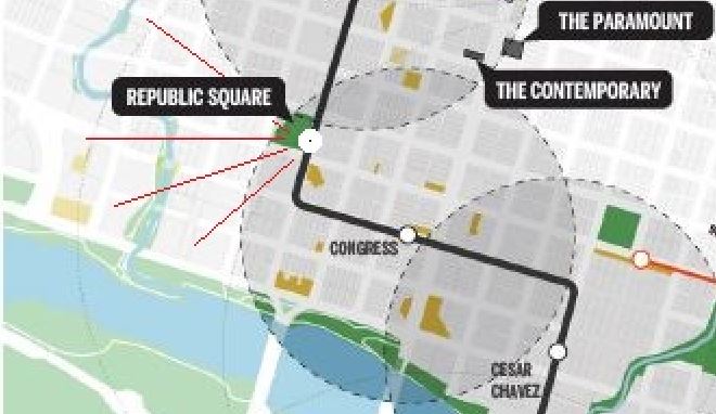
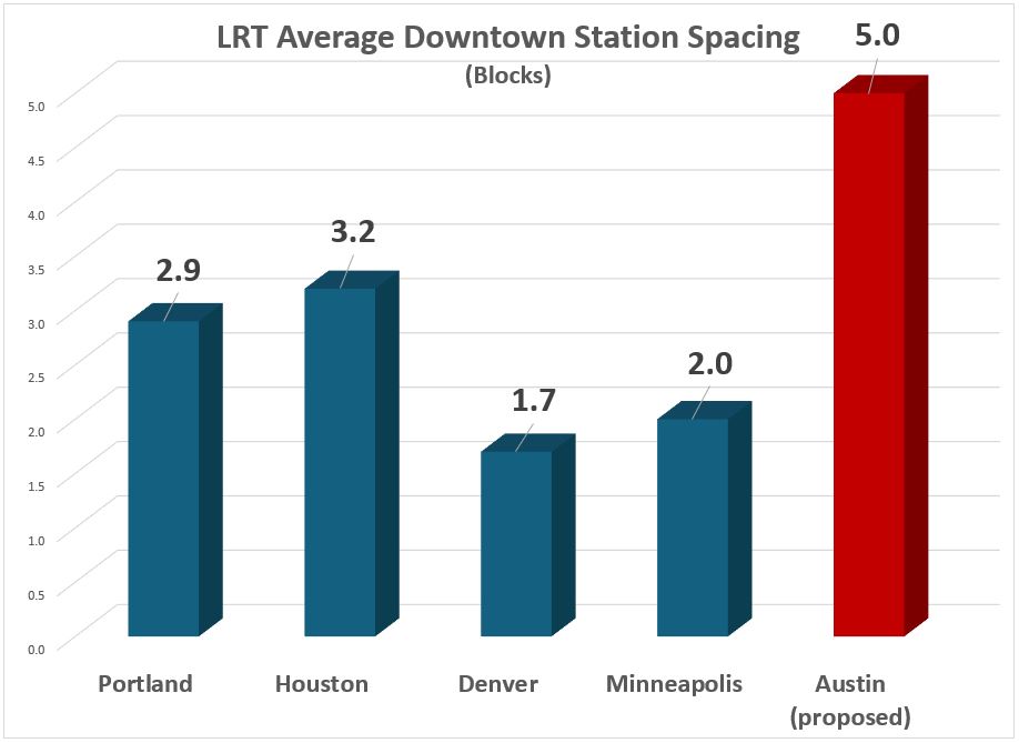
h1

Why Austin is faced with a “Worse-Than-Nothing” urban rail plan

2 November 2014

Graphic via Blip.tv

Graphic via Blip.tv

By Dave Dobbs

The pro-transit group AURA (Austinites for Urban Rail Action) is owed a strong acknowledgement of thanks for posting their exposé pointing out the Republican origins of the money behind Let’s Go Austin’s campaign to try to paint all the opponents of the City’s urban rail bond proposition as captives of the Tea Party. Special thanks are due to the AURA author(s) and researcher(s) who did the homework. (Also see: Let’s Go Austin — Tea-baiting from an awfully glass house.)

One person commenting recently to a local rail discussion forum made some interesting observations about Let’s Go Austin’s tactics:

I expect they’ve taken this angle because their polling says the most popular way to portray the bond is “progressive.” … I think the best chance for defeating Prop 1 is sowing doubt among the self-identified “progressives.”

I think these comments are absolutely right about sowing doubt with progressives about the forces behind the Project Connect Riverside-Highland rail bonds. AURA’s blog post reminds us of Deep Throat’s advice to Woodward and Bernstein in All The President’s Men: “Follow the money!” and Ben Bradlee’s recent death reminds us that this advice still holds today.

Uncovering the money trail reinforces my belief that the Austin rail bonds are really about maintaining “business as usual” with as little disruption as possible. In answer to “Why” Austin has a “Worse-than-Nothing-is-Doing-Stupid-Things” rail plan, I’ve offered the following analysis.

I believe that the powers-that-be chose this approach because it is the approach that does as little as possible to disturb the status quo, while at the same time tying up Capital Metro’s assets far into the future with a faux solution that benefits some of the folks in the Real Estate Council of Austin (RECA) and Greater Austin Chamber of Commerce tent (emphasis here on “Greater”). This satisfies certain city developer insiders who see the rail line as their ticket to access and greater densities, while at the same time perpetuating the business-as-usual-sprawl-ever-outward real estate speculators who need more and more roads to realize their investments on the urban fringes.

Generally, city developers and suburban developers are natural enemies, and this is the compromise to keep order in the house. An ineffectual rail start contingent upon the new city council issuing $400 million in certificates of obligation for road improvements before the bonds can be used, is a pretty clear indication of priorities. So is the fact that the city continues to collect a quarter of Capital Metro’s one-cent sales tax that is mostly spent on roads.

This explains why Guadalupe-Lamar, where light rail would be a smashing success with 40,000 riders daily, was never considered, because a G-L rail line would totally change Capital Metro from “cash cow” to a recognized indispensable tool for bringing growth into city neighborhoods sans the traffic impacts that choke the densities necessary for a more productive tax base, while at the same time creating a demand for more train service in other parts of Austin. It would also build bus ridership because buses would be shuttles to train service for people who would not otherwise use buses. And, in turn, this would create greater public demand to spend more money on public transit, bikes, and pedestrians and less for bigger, wider roads.

Given this reality, fringe-area developers and their political surrogates who control the political process want to minimize the market availability for the alternative lifestyles that many retirees and millennials are seeking. In order to do that, Capital Metro must remain an impotent dog at the heals of Austin’s road warrior masters and suburban real estate investors. (That”s polite talk for “land speculators”.) ■

h1

Derailing the Mueller urban rail express — Preamble to Project Connect’s 2013 “High-Capacity Transit Study”

2 November 2014

Urban rail concept started as a plan for a streetcar "circulator" system, shown in this early map from 2006. Map adapted from Austin Chronicle.

Urban rail concept started as a plan for a streetcar “circulator” system, shown in this early map from 2006. Map adapted from Austin Chronicle.

To understand the roots of the Highland-Riverside urban rail plan on the ballot today, you need to understand how an official “express train” planning process, aiming to lock in an urban rail line to the Mueller redevelopment site, got derailed and sidetracked by community intervention. Here’s a very abbreviated version of the story.

Austin’s current “urban rail” planning arose ca. 2005-2006 following the November 2004 voter approval of Capital Metro’s “urban commuter rail” project, in a package (including “rapid bus” service) called All Systems Go proposing the operation of DMU (diesel multiple-unit) railcars between downtown and the suburb of Leander. The previous light rail (i.e., urban rail) plan for a line on Guadalupe, North Lamar, and the railway alignment northwest as far as McNeil had been shelved in mid-2003 in favor of the cheaper, but very bare-bones, DMU plan.

Since the newly approved DMU line ran on a railway alignment that bypassed most of the heart of the city, ending only at the southeast corner of the CBD, officials and planners realized they needed some way to connect passengers with key activity points, including UT and the Capitol Complex. The answer they devised was a “circulator” system using streetcar technology, which would intersect with the DMU line (eventually rebranded as MetroRail) and connect to downtown Austin, the east side of the Capitol Complex, the East Campus of UT, and the Mueller development site. (See map at top of post.)

But, critics asked, what about the dense West Campus neighborhood and the busy commercial district on The Drag? What about the original plan for light rail along Guadalupe and Lamar? The “rapid bus” service included in the All Systems Go package, intended as a precursor to rail in the Guadalupe-Lamar corridor, was then viewed only as a temporary “fix”, and it seemed clear that rail needed to be planned for that corridor as well.

Within Capital Metro, Lyndon Henry (then a Data Analyst with the transit agency) pressed the case for at least an initial rail line to serve The Drag and West Campus, and at public meetings on the proposed “circulator” Henry and others continued to raise the issue. In this period, as problems emerged with the MetroRail project, Capital Metro’s involvement in the streetcar project was superseded by the City, which assumed control. When Henry’s supervisor Matt Curtis left Metro to become an aide to Mayor Lee Leffingwell, for a brief period a West Campus spur did appear in City of Austin planning maps for the proposed streetcar. (Henry is currently a contributing editor to this website.)

In 2008, as a line on East Riverside to ABIA, with a bridge over the river into the CBD, was proposed, planners became convinced that capacity and speed required fullsize light rail transit (LRT) rolling stock. However, apparently to distinguish the emerging plan from the original, centrally routed Guadalupe-Lamar line, and to retain some of the supposed lower-cost ambience of streetcar technology, the expanded system was dubbed “urban rail”, supposedly a hybrid between a streetcar and a rapid LRT system. By 2010, the Central Austin Transit Study (CATS), prepared by a consortium headed by URS Corporation, recommended a system that stretched from the Mueller site, down Manor Rd. and Dean Keeton to San Jacinto, then south through the East Campus, across the river, and out East Riverside to ABIA. Alternative alignments were suggested, and spurs to Seaholm and the Palmer Auditorium area were also proposed as later extensions.

As the project made its way through the National Environmental Protection Act (NEPA) process, and afterward, the route structure gradually solidified; for a connection to Mueller, a preference was emerging to move the alignment from Manor Rd. to a route via Red River and Airport Blvd. But even the gesture of a spur connection to the West Campus began to vanish, prompting Lyndon Henry and the Light Rail Now Project to call attention to the need for urban rail in the “Missing Link” — the gap between MetroRail’s station at Crestview and North Lamar, and its terminus downtown. Because of that gap, not only were passengers inconvenienced by having to transfer to buses to access their destinations along the Guadalupe-Lamar corridor, but also Capital Metro was running costly bus shuttles to connect MetroRail stations on the east side to the UT campus and the Capitol Complex. See: Give priority to “Missing Link”.


MetroRail Red Line (red) skirts entire heart of central Austin, illustrated by "Missing Link" through Guadalupe-Lamar corridor. Urban rail would provide the crucial connections to core neighborhoods, UT West Campus, and Capitol Complex missed by MetroRail. Infographic Map by Light Rail Now.

“Missing Link” urban rail (green), in Guadalupe-Lamar corridor, would provide the crucial connections to core neighborhoods, UT West Campus, and Capitol Complex missed by MetroRail (dashed red line). Infographic Map by Light Rail Now.


But why had the West Campus, and Guadalupe-Lamar, disappeared from the official urban rail plan? As Henry, Dave Dobbs, Andrew Clements, Roger Baker, and others persistently raised this issue, mainly at meetings of the Transit Working Group (a blue-ribbon committee of civil leaders nominally attached to CAMPO, the Capital Area Metropolitan Planning Organization), planners and officials under the aegis of the Project Connect public agency consortium pointed to a Route Alternatives Evaluation Process included in the 2010 CATS project that had supposedly ruled out a “University of Texas (UT) to North Central Austin (Hyde Park)” route, instead giving top scores to routes serving Mueller, East Riverside, and Seaholm — basically, what City policy actually wanted.

Scrutinizing the “Route Alternatives Evaluation”, Henry identified serious methodological drawbacks and summarized these in a commentary, City’s Urban Rail “alternatives analysis” omitted crucial Lamar-Guadalupe corridor! presented to the TWG on 27 April 2012. These problems are also discussed in our article City’s 2010 urban rail study actually examined corridors! But botched the analysis… (26 November 2013). Basically, the 2010 “evaluation” totally ignored the Guadalupe-Lamar corridor, and “evaluated” an array of alternatives with subjective ratings of 1, 2, or 3. Thus, voila! The preferred official routes, including the route to Mueller, won the “competition”!


CATS map of actual potential rail corridors studied. Map: COA and URS.

CATS map of potential rail corridors studied — but Guadalupe-Lamar was omitted! And subjective scoring system facilitated ratings that favored City’s desired route plan. Map: COA and URS.


In what seemed like an Urban Rail Express to Mueller, by May 2012, the official urban rail proposal had gelled into a Phase 1 project running 5.5 miles from downtown, through UT’s East Campus via San Jacinto, then northeast via Red River St., 41st St., and Airport Blvd. into the Mueller site. The total investment cost was estimated to be $550 million.


Finalized in May 2012, 5.5-mile, $550-million Phase 1 urban rail starter line was proposed to connect downtown, UT East Campus, Hancock Center, and Mueller site. Graphic: Project Connect.

Finalized in May 2012, 5.5-mile, $550-million Phase 1 urban rail starter line was proposed to connect downtown, UT East Campus, Hancock Center, and Mueller site. Graphic: Project Connect.


But the constant pounding by community critics — especially Lyndon Henry’s exposé of the outrageously dubious Route Alternatives Evaluation from 2010 — was taking its toll. The result was that Project Connect placed the Mueller Phase 1 plan on hold and shifted course dramatically. In early 2013, Kyle Keahey was hired as Urban Rail Lead to head a new “High-Capacity Transit Study”, tasked with supposedly re-evaluating everything, racing through a process (with a presumably more competent and defensible methodology) that would result in a recommendation by the end of 2013.

To some, it seemed a new beginning and a possibly more hopeful and fair approach to analyzing travel corridors, particularly the heavily traveled, high-density, and widely popular Guadalupe-Lamar corridor. Unfortunately, that was not to happen. As it proceeded, it became increasingly clear that the much-vaunted “High-Capacity Transit Study” was actually a fraud. The highlights of this process will be summarized in a subsequent report. ■