
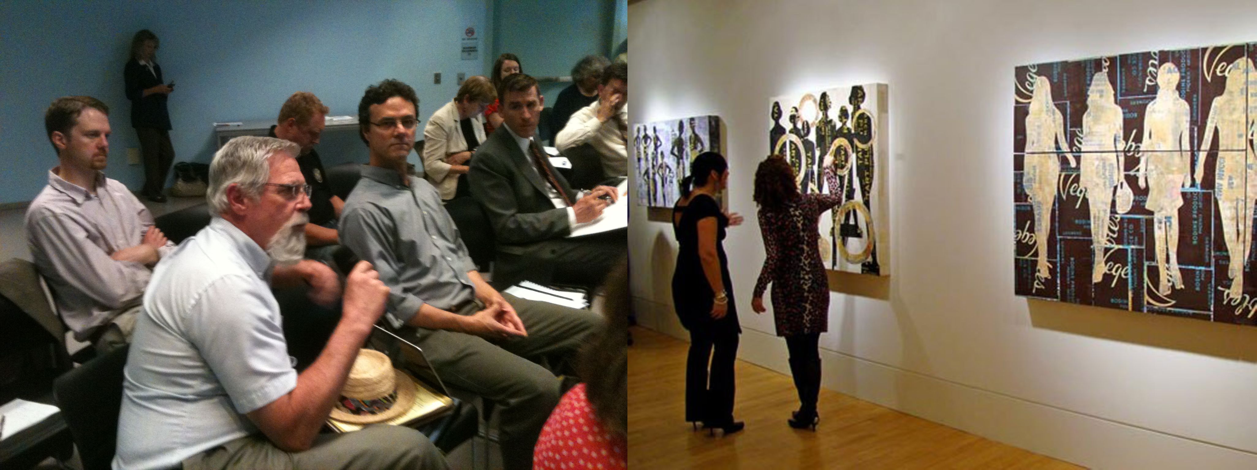
Community meeting (left) vs. art gallery (right)
♦
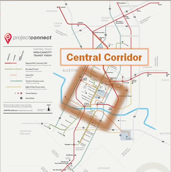
In our article of Sep. 17th, If you support urban rail for Guadalupe-Lamar, attend these community meetings! Austin Rail Now reported that
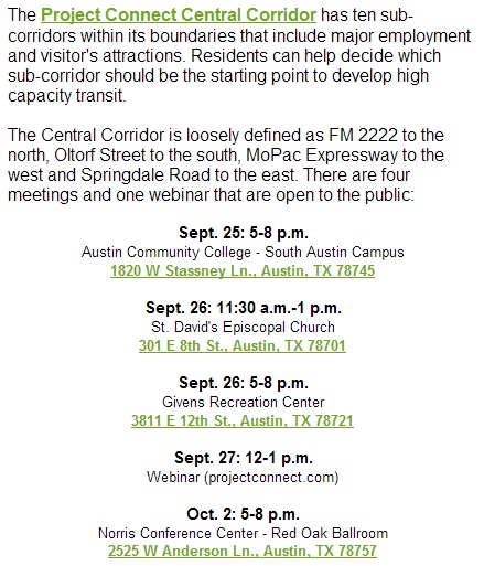
… Project Connect has scheduled some upcoming meetings (and a “webinar”) between Sep. 4th and Oct. 2nd (details below) that seem to offer a bona fide opportunity for the public to meet in a community fashion, both discussing the issues and interacting with one another.
Unfortunately, the prospect of bona fide public meetings “for the public to meet in a community fashion, both discussing the issues and interacting with one another” no longer seems valid.
In a sudden reversal — and what appears to be a breach of trust and a breach of a de facto agreement with many in the Austin community — Project Connect has abruptly stopped describing the forthcoming Urban Rail Central Corridor public involvement events as meetings, and instead is now promoting them as so-called “Open Houses”.
The Sep. 23rd edition of the Austin Mobility Go! Email newsletter from the City of Austin’s Transportation Department now describes the activities this week as “open houses”, not meetings. This was confirmed in Email comments from Capital Metro/Project Connect community outreach specialist John-Michael Cortez:
It is labeled as an Open House because that connotes that people are free to show up at any time, unlike a public meeting or workshop, which usually has a set agenda and starting time, thus limiting full participation to those who are able to show up at the start of the meeting. These meetings will be more of a hybrid open house/workshop. Participants can come at whatever time they choose and be able to see exhibits and speak directly to agency staff to have their questions answered, and formal input will be gathered through questionnaires and encouraging participants to draw and make comments on sub-corridor maps.
This is a crucial point, and one that many community activists involved with the urban rail planning process thought had been settled — in favor of community meetings.
Meetings are fundamental to truly democratic process. They allow for community interactive input, i.e. community discussion along with the project personnel. They bring members of the entire community together, allow them to hear ideas and views from one another, allow them to interact on the public record (or at least with public witnesses) with officials present, force official representatives to deal with and respond to difficult questions and issues, and allow officials and participants to get a sense of community attitudes expressed in a community manner. One person’s question or comment may give ideas or motivation to other participants.
This community interactivity is lost in the individual, one-on-one format of “Open Houses”, which have no set agenda, no community public speaking, and involve agency personnel displaying graphics of their pre-determined plans and chatting individually with the occasional community members that might attend the event. Transportation consultant Lyndon Henry (an Austin Rail Now contributor) has compared these events to wandering through an art gallery, with the chance to chat individually with the gallery guards (agency personnel). There’s no opportunity for real interactive community involvement.
In the view of local Austin researcher and transportation activist Roger Baker,
The major problem I see is that while Open Houses usually have lots of big impressive maps, these meetings commonly tend to evolve toward little unstructured conversation clusters, with an official at their center, near a map, and with others standing around, trying to hear, waiting to ask their own questions. Every citizen can come in and ask the same question as those who came earlier, and these exchanges are essentially rambling private discussions that tend to go on and on without clearly answering certain important policy questions. Usually there is no record of the questions asked, nor the responses given. These events tend to become a succession of unrecorded one to one exchanges.
In a comprehensive explanation and analysis of public involvement, the Federal Highway Administration (FHWA) explains that
Meetings provide a time and place for face-to-face contact and two-way communication-dynamic components of public involvement that help break down barriers between people and the agencies that serve them. Through meetings, people learn that an agency is not a faceless, uncaring bureaucracy and that the individuals in charge are real people. Meetings give agencies a chance to respond directly to comments and dispel rumors or misinformation.
Far from being passive gatherings, meetings are interactive occasions when people discuss issues of consequence to them and their neighbors, listen to opposing viewpoints on the issues, and work together for the common good. Agency staff people who handle public meetings need to be trained in skills that encourage interaction and also keep the process focused and productive.
In contrast, says FHWA,
An open house is an informal setting in which people get information about a plan or project. It has no set, formal agenda. Unlike a meeting, no formal discussions and presentations take place, and there are no audience seats. Instead, people get information informally from exhibits and staff and are encouraged to give opinions, comments, and preferences to staff either orally or in writing.
Is the planning and decisionmaking process really that important to the kind of plan that emerges? You bet it is.
Vigorous, authentic community involvement is absolutely critical, particularly in injecting new ideas and perspectives, raising special concerns, scrutinizing and evaluating official approaches and decisions, safeguarding the project from the influence of special interests and extraneous political issues, and generally keeping the official planners and decisionmakers “honest”.
Furthermore, voters are far more inclined to support ballot measures for major rail projects if they have a sense of ownership through opportunities for bona fide participation in the process.
Project Connect’s seemingly abrupt decision to downgrade the format of these public events from meetings to “art galleries” (“open houses”) suggests more of a desire to minimize, or squelch, rather than maximize, public involvement and dialogue in the urban rail planning process. This would also appear corroborated by Project Connect’s rather puzzling lack of publicity for these public events.
As Lyndon Henry recently warned, in comments Emailed to a list of community transportation activists,
The consistent and steady pattern by local public agencies (particularly involved in public transportation issues) of degrading the bona fide democratic public participation process over the past period has been alarming, and I did speak out about this when I worked at Capital Metro. Individual chats between individual community members and official personnel do not represent a democratic process of community participation, and I’ve personally seen the level of such participation decline significantly over the past couple of decades. It’s very troubling to see this same policy now being carried forward and rationalized despite assurances made otherwise.
Despite these efforts by Project Connect to discourage public participation, Austin Rail Now continues to urge supporters of a Phase 1 urban rail starter line in the Guadalupe-Lamar corridor to attend these events and vigorously express their views.


