Austin’s 2000 light rail plan — Key documents detail costs, ridership of Lamar-Guadalupe-SoCo route
4 May 2014♦
Throughout the debate over urban rail for Austin, and especially Project Connect’s self-styled “central corridor study”, transit advocates who’ve insisted that the Guadalupe-Lamar (G-L) corridor offers a far better route alignment than the more easterly alignment preferred by Project Connect have emphasized the salient advantages of G-L — the core city’s heaviest local arterial traffic flow, vibrant and long-established commercial activity, numerous major activity centers, the very densely populated West Campus — as reasons for anticipating an extremely effective, affordable, and successful urban rail project in this corridor.
These expectations are supported in key official documents produced in the period 1999-2000. In addition, in a comparison of equivalent metrics with the Project Connect plan, the superiority of a Guadalupe-Lamar urban rail alignment is clear. Austin Rail Now is making these two critical documents available as PDF files linked in this posting:
• Capital Metro – Annual Report on New Starts – Executive Summary (November 10,1999)
This important document was formerly available on Capital Metro’s website, but apparently has been removed. This PDF was created from a hardcopy in the possession of Lyndon Henry.
• Federal Transit Administration – Austin Light Rail Corridors – Austin, Texas (November 1999)
This document no longer remains available as a webpage at the FTA’s site. For convenience, Austin Rail Now has posted a PDF on this site. (Note: This has been updated since original posting.)
Project Connect’s plan, at last revealed on May 2nd to a meeting of the Central Corridor Advisory Group (CCAG), proposes an easterly alignment running about 9.5 miles from the Highland/Austin Community College site, through the East Campus of the University of Texas, through the east side of downtown, across the Colorado River, to Grove Blvd. on East Riverside Drive. The investment cost was estimated at about $1.4 billion (about $145 million per mile), yielding projected ridership of 16,000 to 20,000 per day (average weekday).
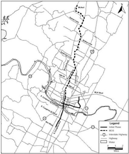
In contrast, the official documents cited above for Capital Metro’s 2000 light rail plan in the Lamar-Guadalupe-South Congress (SoCo) corridor provide an authoritative basis for a comparison. Capital Metro’s proposal was sectioned into two parts — a shorter Minimum Operable Segment (MOS), running from McNeil Rd. in north Austin — using railway right of way (now used by today’s MetroRail), then Lamar-Guadalupe — to the CBD, and a full Phase 1 plan, which added a line down South Congress to Ben White, and another branch on Capital Metro’s railway right of way to Pleasant Valley Rd. (See map at top.)

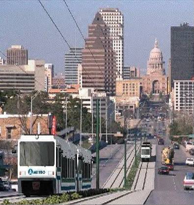
Capital Metro’s 2000 light rail plan envisioned urban rail running through the SoCo area. Simulation: Capital Metro.
As you can see from the information in these documents, the 2000 route plan benefited from the heavy travel densities in these key central corridors, the plethora of major activity centers, and the higher population densities, especially in the West Campus area.
• MOS (McNeil Rd. to CBD) — This 14.6-mile initial starter line segment was projected to cost $739.0 million in 2007 (Year of Expenditure) dollars. In 2014 dollars, this comes to roughly $878 million, or about $60 million per mile — about 41% of the per-mile cost of the Project Connect plan. That’s for about 54% more miles of route. Ridership for the forecast year (2025) was projected at 37,400 per day — 87% higher than Project Connect’s “high” estimate of 20,000 for their own plan.
• Phase 1 (full MOS, East Austin, SoCo) — The full 20.0-mile Phase 1 plan carried a projected cost of $1,085.8 million in 2010 (YOE) dollars. In 2014 dollars, this tallies to about $1,198 million, or (again) about $60 million per mile and about 41% of the unit cost of the Project Connect plan. And that’s for more than double the route-mileage. Yet ridership for the 2025 forecast year was projected at 51,000 per day — over 2.5 times higher than Project Connect’s “high” estimate of 20,000.
Thus, as these documents reveal, for a dramatically lower cost per mile, and total cost, either the “starter line” MOS plan or the full Phase 1 plan centered on the Guadalupe-Lamar corridor delivered strikingly higher ridership, in comparison with the proposal offered by Project Connect and Austin’s current leadership. In other words, far more bang for the buck.
Why would Austin citizens want to invest in Project Connect’s plan, which costs so much more for so much less ridership? This question, and these comparisons, should be kept well in mind by both Austin decisionmakers and the public at large as they continue to ponder the Project Connect plan vs. alternatives for the Guadalupe-Lamar corridor. ■


While I too am in support of a more centrally routed urban rail system, it is somewhat simplistic and disingenuous to compare ridership and inflation-adjusted cost forecasts made nearly 15 years ago. The city has changed too much since then in terms of population and land use to make it a fair comparison, especially without knowing the methodology behind the estimates. What we need is a new in-depth study of the costs of installing light rail along the G-L corridor, which I’m sure would yield much different estimates beyond a simple inflation factor.
We think the inflation-adjusted cost and ridership projections remain valid for a comparison with Project Connect’s own “order of magnitude” cost estimates and “rough” ridership projections. Certainly, demographics and other features can change somewhat over 10-15 years, but if anything, they’ve probably changed to make the original ridership forecasts rather conservative given today’s conditions. As for cost, there appear to be no changes in physical characteristics in the corridor or in light rail technology or regulatory requirements that would dramatically alter the basic assessment so as to make it obsolete.
However, we agree that a more in-depth re-study of the corridor would be desirable, and would very likely yield somewhat different cost estimates. Unfortunately, Project Connect had the opportunity to study the G-L corridor as well as other travel corridors, but ignored actual corridors, focusing the staff’s time and resources on carrying out a “beauty contest” among various broad urban sectors instead. Afterwards, they manipulated data, much of it highly dubious, to justify what seems to be a preordained selection.
— ARN editor ■
[…] • Austin’s 2000 light rail plan — Key documents detail costs, ridership of Lamar-Guadalupe-SoCo ro… […]
[…] Line and a bridge across Lady Bird Lake. The narrowly defeated 2000 light rail proposal would have carried nearly double the riders for nearly half the cost. Transit proponents like me balked. So did the […]