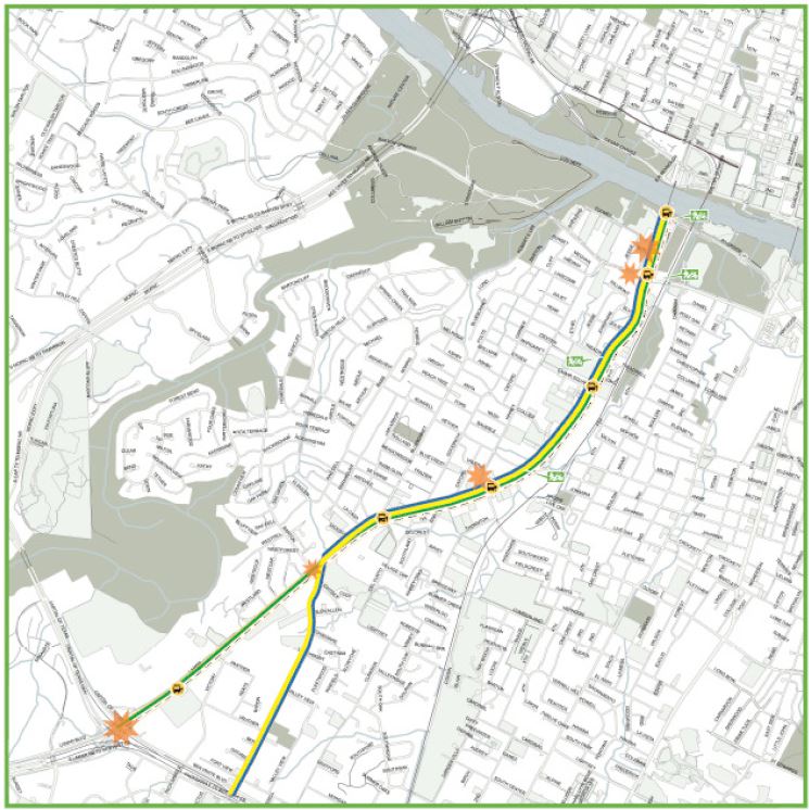
Republic Square station would provide southwest sector of downtown 4-5 minute connectivity to light rail as illustrated by red lines. Graphic: ARN, adapted from original DAA map.
By Lyndon Henry, Editor
Why are urban rail stations in downtowns – central business districts (CBDs) – typically spaced so much more closely than in outlying stretches of rail lines? Of course, one major reason is that more frequent stations are needed to serve the density of these highly compacted activity concentrations – employment density in particular, although population density in city centers, like Austin’s, has also been increasing.
Commuters to downtown jobs will tolerate a longer walk to an outlying light rail transit (LRT) station, or even access of a mile or more to a park & ride. But over a century of experience has shown that most people don’t want to spend much above about five minutes walking to their workplace from their transit stop. Or from their workplace to the nearest transit station, to commute home at the end of a day’s work.
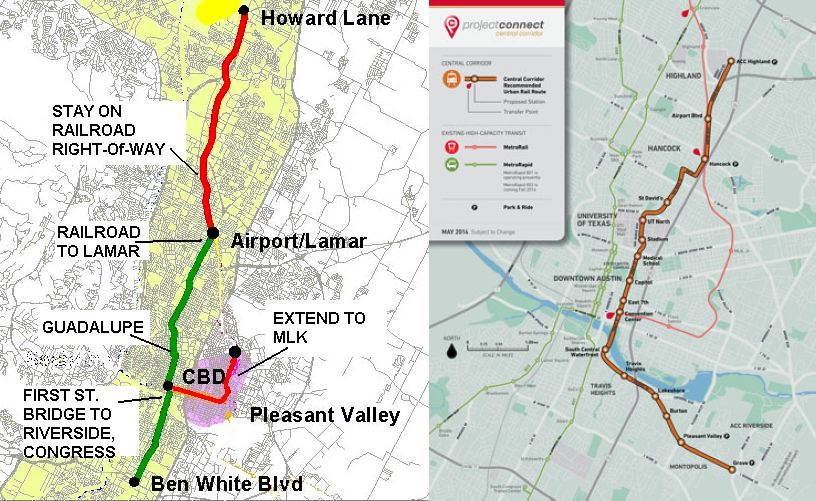
To some extent, in Austin Rail Now’s previous post, these factors are reflected in the map-graphic shown (originally prepared by the Downtown Austin Alliance (DAA) and included in a public document by the Austin Transit Partnership). Using shaded circular areas around several proposed downtown LRT stations, the graphic illustrates a quarter-mile/five-minute walk distance around each station. While the DAA’s graphic bolsters the case for adding a Wooldridge Square station to the LRT plan (an addition we strongly support), it also exposes a large gap in coverage for the southwest segment of downtown.
Republic Square station fills need
This gap can be filled by a Republic Square station (between W. 4th and 5th Streets), as shown in the graphic above (at the head of this article), which we’ve adapted from the DAA map. On our graphic, red lines radiating westward from the proposed station indicate approximate 4 to 5-minute walk distances to points in this area. Southwest downtown includes such major sites as the Federal Courthouse, the Seaholm development (with various shops and restaurants), the Austin Central Library, and several large condo and apartment highrises. The district also includes a multitude of other establishments, such as smaller shops, hotels, restaurants, and more. A Republic Square LRT station would also be just six blocks from the major westside Whole Foods Market.
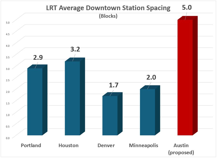
The need for another downtown station (in addition to stations already proposed by the Project Connect team and the DAA’s Wooldridge Square concept) is highlighted in the following graph comparison of station spacing. This uses roughly equivalent block lengths in several peer cities (considered quite successful in the industry); the data used for Austin includes the proposed Wooldridge Square station, which Project Connect considers an “option”. This comparison suggests that the downtown station spacing so far proposed for Austin’s coming LRT system seems inconsistent with Best Practices by these typical peer systems.
Even with “optional” Wooldridge station, proposed spacing of Austin’s downtown LRT stops appears to violate Best Practices of several peer city systems. Graphic: ARN.
Easy Interface with current transit hub
In addition to ease of access, another factor typically involved in the layout and spacing of downtown stations is the need to minimize peak crowding and to avoid overcrowding at any station in these high-population areas. Providing too few stations in these situations (which may be indicated by longer stop-spacing) can create excessive crowding that is unpleasant, dangerous, and disruptive to smooth operation and service.
And in regard to the proposed Republic Square station specifically, there’s another major consideration: the opportunity for LRT to interface with the major bus transit hub at Republic Square, which has functioned for years to provide a relatively smooth interface among routes, well-known to the public.
In artistic simulation, a light rail train rolls through Republic Square – but without a station! Graphic: Austin Transit Partnership.
Not only is the Republic Square hub well-established and familiar to the transit-riding community, it’s positioned six blocks (along 4th St.) from the downtown MetroRail station at the Austin Convention Center, providing a feasible interconnection between MetroRail and the large assortment of bus routes converging at Republic Square. Adding an LRT station here would expand Republic Square’s role into a multi-modal transit hub.
For multiple reasons, a Republic Square station would fill a critical need and eliminate the remaining serious gap in the proposed downtown LRT alignment. But if this gap were to remain in the final plan, we can’t help imagining whether future generations of Austinites will be wondering: “What were they thinking?” And it’s critical to keep in mind here that retrofitting an urban rail station into an existing alignment – particularly in an intensively developed central-city environment – is far more expensive than including it in the original construction project. ■
Wooldridge Square Station proposed by DAA, showing connectivity benefits. Source: DAA via Austin Transit Partnership.
By Lyndon Henry, Editor
In my December 18thARN article, “Downtown Light Rail Plan Needs More Stations”, I explained the need to include additional downtown stations in Project Connect’s revised surface-routed light rail transit (LRT) plan, and specifically recommended adding stations on the Guadalupe St. alignment at Republic Square (W. 4th St.) and W. 10th St. (Wooldridge Square). As I noted, these proposals were developed via my discussions in the previous spring and summer of 2023 with ATP staff and technical advisory committee members; they were eventually presented in a June memo.
As it turns out, the Downtown Austin Alliance (DAA, a consortium of downtown businesses, real estate interests, developers, and related interests) had also perceived the need for at least one additional station – at Wooldridge Square, just as I have also recommended – and included a proposal for such within a memo dated 10 May 2023 to Austin Transit Partnership (ATP) Executive Director Greg Canally. (This is contained in ATP’s Austin Light Rail: Community Engagement Report, a document released publicly in May 2023.)
The Wooldridge Square Station proposal is shown in a graphic map appendix, labeled “Wooldridge Station Connectivity”, illustrating the additional coverage that the station would provide within a ¼-mile radius, and sites of key interest made more accessible by such a station (this is the head map-graphic at top of this post).
As I had pointed out in my own June 2023 memo, Project Connect’s revised plan for downtown was proposing “exceptionally long spacing between stations for a major dense central area, and I believe it is inconsistent with Best Practices ….” DAA’s memo seems to provide some corroboration for this assessment, while emphasizing the enhanced accessibility provided by a Wooldridge Square station:
As currently proposed, the distance between the Congress and 15th Street stations is approximately one mile. We recommend adding an additional station in the vicinity of Wooldridge Square and Sweatt Travis County Courthouse. This would lessen the distance between the Congress and 15th Street stations to less than half a mile and would provide much needed access to courthouses (federal and state), Austin Community College, Pease School redevelopment, Austin History Center, the Paramount and the Old Bakery. It would also facilitate east-west transfers to frequent bus routes at 7th/8th Streets, providing potential congestion relief at Republic Square.
For sure, DAA’s proposal to add a Wooldridge Station represents an important and crucial improvement for the planned downtown LRT alignment. So far, Project Connect and Austin Transit Partnership have presented this as a possible design “option”. Hopefully this will be accepted as a definite element of the plan.
But a Republic Square station is also essential for adequate connectivity and accessibility in Austin’s downtown. The case for this will be presented in a subsequent analysis to be posted shortly. ■
Simulation of LRT train on Guadalupe St. at Republic Square from Project Connect’s revised plan. But so far, the plan does not actually include a station at this crucial downtown transit hub! Source: ATP
By Lyndon Henry, Editor
Austin’s light rail transit (LRT) project continues to progress despite difficulties. The Austin Transit Partnership (ATP) and Project Connect (PC) planning team have so far been able to overcome serious legislative and litigational threats from public transport opponents. Equally important, they’ve managed to navigate through serious budget problems arising from design complications, external economic inflation, and other factors.
It’s a relief at last to have the workable (and hopefully entirely affordable) 3-branch light rail transit (LRT) system plan that ATP has adopted, shown in this map, publicly released this past May, which indicates proposed station locations as well as planned future line extensions:
ATP’s proposed Phase 1 surface LRT plan. Source: ATP
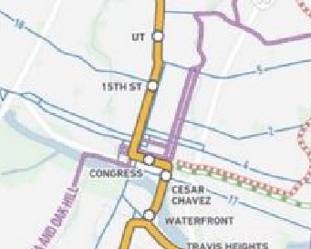
The revised downtown route is a surface alignment following several streets: Trinity St., 3rd St., and Guadalupe St. However, in discussions this past spring and summer with ATP staff and technical advisory committee members, I called attention to a major concern with respect to the small number of stations – just three – to serve both Downtown and the Capitol Complex – i.e., two-thirds of Austin’s critically important Central Area. All three proposed station locations – Cesar Chavez, Congress, and 15th St. – can be seen on this closeup from the map:
Closeup of LRT map with proposed downtown stations (Cesar Chavez, Congress, 15th St,)
This deficit in stations results in a serious problem of inadequate station spacing in this key activity center complex. In particular, there is a 14-block gap (in line length) between the proposed Congress station (located on 3rd St. west of Congress Ave.) and the proposed 15th St. station (on Guadalupe). The route distance (per Google Maps) for this gap between these two stations measures 5,633 feet. That’s 1.1 mile, or 1,717 meters, between these stations.
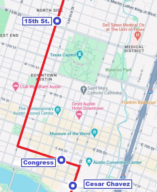
The following more detailed map graphic, created from Google Maps, facilitates a more accurate assessment of the proposed LRT route and stations within the grid of streets, blocks, and major landmarks, and a better visual sense of the lack of stations along Guadalupe St., resulting in the sizable gap between the proposed Congress and 15th St. stations.
ATP’s proposed downtown LRT route and stations. Source: LH, via Google Maps
This is an exceptionally long spacing between stations for a major dense central area, and it appears to be inconsistent with Best Practices as exhibited by downtown route configurations in peer cities, particularly with central-city surface alignments, such those in as Portland, San Diego, Sacramento, Phoenix, Minneapolis, Dallas, Houston, Denver, Salt Lake City, and others, where spacing typically ranges from 3 to 8 blocks. In fact, I can’t immediately think of any other light rail system in North America with a station spacing that wide in the heart of its downtown.
Transportation consultant Jarrett Walker has discussed the stop-spacing issue on his website, HumanTransit.org: Basics: The Spacing of Stops and Stations. As Walker notes, “… transit planners generally observe that the walking distance that most people seem to tolerate — the one beyond which ridership falls off drastically — is about 400m (around 1/4 mi) for a local-stop service, and about 1000m (around 3/5 mi) for a very fast, frequent, and reliable rapid transit service.”
Here, Walker is discussing stop-spacing for a city as a whole. However, it’s crucial to consider the particular factors in play regarding the spacing of stations and adequate access in a downtown or other densely concentrated high-activity area. Given the dense mesh of downtown street structure, a circular radius yardstick doesn’t seem adequately applicable – transit users can’t walk in straight-line radii between worksites and transit stations, they must follow the zig-zag street configuration, which significantly increases total access distance. Plus additional time spent waiting at traffic lights must be taken into account.
Real access time in minutes would probably be a better comparative measure of ease of access. And it’s not just a matter of convenience. This means that excessively wide station spacing in a downtown may impair access, discourage use of the transit service, and thus significantly reduce ridership. It also imposes extra difficulty for the elderly and mobility-challenged. Potentially the problem could also damage public goodwill.
While the Project Connect team has expressed concern about steep gradients on Guadalupe at 5th St. and several blocks north that affect station construction, I note that industry guidelines are not rigid but do allow design to follow existing street gradients where this can be done consistently with safety and Best Practices. (Reference: TCRP Report 155, 2nd Ed. 201; U.S. Access Board, Accessibility Standards.)
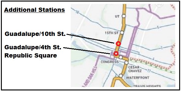
Taking into account these considerations, to remedy this (so far publicly presented) 1.1-mile gap in downtown LRT station spacing, on 28 April I proposed that at least two additional downtown stations on Guadalupe St. be added to ATP’s revised surface LRT plan. As illustrated in the small amended map segment presented below, these include a station at 4th/Guadalupe to serve the existing transit hub at Republic Square and the lower west side of downtown, as well as a station at 10th/Guadalupe, intended to improve accessibility to the north end and upper west side of downtown, including the Travis County Courthouse, many legal and professional offices, and the Austin History Center.
Proposed additional downtown stations. Source: LH
ATP personnel indicated that they were considering these proposals, and the broader possibility of adding more downtown stations to the revised LRT plan. So far, no changes have been publicized. ■
Proposed alternative Orange Line alignment. Source: L. Henry (click on graphic to enlarge).
By Lyndon Henry
Lyndon Henry, an urban and transportation planner, is a technical consultant to the Light Rail Now Project of Texas Association for Public Transportation (a Texas nonprofit organization) and contributing editor to Austin Rail Now (ARN). He is also a member of the Engineering, Architecture and Construction (EAC) Advisory Committee of the Austin Transit Partnership (ATP), the public agency overseeing Austin’s major transit development program (including light rail) approved by city voters in November 2020.
In April 2022, Project Connect reported it was encountering a $4.5 billion budget overrun in its light rail transit (LRT) program, of which $3.9 billion was linked to the Orange Line and tunnel segments. In a May2022 memo to the EAC committee, Lyndon noted that much of this “appears to be a result of the extension of the subway tunnel under the river, the South Bank, and South Congress Avenue” (which had replaced an earlier conception of a surface alignment and bridge). As remedial measures, Lyndon offered proposals to consolidate the Orange and Blue lines into a single tunnel alignment through downtown and onto a single crossing, by bridge, over the Colorado River (Lady Bird Lake). These ideas are being considered by the Project Connect team as possible design alternatives.
In an effort to contribute to the “criteria evaluation and project optimization” goals of a 22 October Light Rail Workshop of several ATP advisory groups, including the EAC, Lyndon submitted a handout proposing his tunnel and bridge consolidation plan plus suggesting a redesign of the South Congress light rail extension as a surface alignment, “avoiding the heavy cost of a subway tunnel in this segment.” These ideas “appear to offer potential to reduce cost and speed up construction, helping to fulfill what voters have approved” he noted, adding that “Hopefully, at least a portion of the proposed extension into Central South Austin might be completed per the original schedule.” The below presents the proposals in that workshop handout.
With serious potential budget overruns posed by the transit system plan designs to date, the Project Connect team has been seeking ideas for alterations and alternatives. Here are some of my own thoughts and proposals toward “criteria evaluation and project optimization” as requested in this workshop.
Securing public trust
A major premise of my approach, based on 50 years of involvement and research in public transportation, is that maintaining public trust is absolutely crucial to a project of this importance and magnitude.
Public expectations should be highly valued. Accordingly, my proposals are intended to maintain as much of the original light rail transit (LRT) route structure and completion schedule as possible, remaining faithful to what voters have approved. Given the budget problems and constraints that have emerged, this seems to imply some major changes to plan configurations, particularly infrastructure design, to reduce budgetary investment cost and minimize construction time.
Downtown subway reconfiguration
In the map [shown above] (originally presented to the EAC Advisory Committee in May), I have proposed an alternative alignment for the Orange Line southward from Republic Square, eliminating the currently proposed tunnel under the river to the South Bank and into South Congress Avenue. Instead, from Republic Square southward the Orange Line would follow the Blue Line alignment via the 4th St. tunnel, then the Trinity tunnel. Emerging just north of the Colorado River, the Orange Line would then share the proposed bridge over to the South Bank.
On the South Bank, the Orange Line would branch westward via available real estate and Riverside Drive right-of-way over to South Congress Avenue (a station could be installed in this area to provide approximately 0.4-mile access to Auditorium Shores and the Long Center). Sharing the Blue Line alignment via 4th St./Trinity St. and the proposed transit bridge as an alternative connection from downtown to the South Bank would alone reduce investment cost significantly (perhaps by $1 billion or more). The Orange Line could then proceed into the South Congress corridor either in tunnel or as a surface alignment.
South Congress surface alignment
A surface alignment on South Congress Avenue (as proposed in the original conception of this LRT project) in lieu of tunnelling would offer another means of substantial construction cost and time saving and likely facilitate at least some of the previously proposed extension of the Orange Line into Central South Austin by 2029. Perhaps the widest local arterial in the central city, South Congress offers a virtually ideal opportunity for surface light rail. (See graphic simulation, below.)
Construction of surface facilities (e.g., stations, overhead contact system) should be possible within the Capitol View Corridors (CVC) regulatory guidelines at least as far south as Mary Street. (As defined by the Downtown Commission in a 2007 document, “A view corridor is a plane that extends from a defined view point or points to the base of the Capitol dome. … No structure is permitted to pierce the plane.”) To avoid obstructing the CVC in the remaining short segment from Mary to south of Live Oak St., trains could operate on batteries or perhaps a technology such as Alstom’s proprietary APS (alimentation par sol – ground power) electrification system, which uses a surface power strip between the rails which is electrified only when a train is passing on that section of track.
Simulation of surface light rail alignment on South Congress (courtesy George Barsky)
Rethinking intersection with Cesar Chavez St.
So far, design of LRT alignments downtown has been constrained by the assumption that Cesar Chavez St. with its heavy traffic flow cannot tolerate the interruptions from a surface intersection with light rail. However, LRT lines in various other cities have worked well for decades with surface intersections with similar major arterials (e.g., Portland’s original MAX LRT line has crossed the city’s major 5th and 6th Avenues downtown since 1986). Elimination of this constraint, thus permitting LRT surface crossings of Cesar Chavez, could provide Project Connect greater planning flexibility and lead to even more substantial cost savings. ■
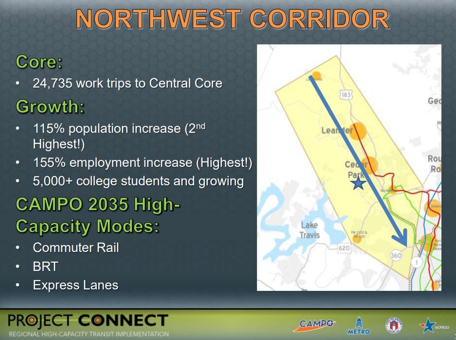
Map shows Red Line and proposed Green Line. Red Line north and west of Crestview station serves metro area’s northwest corridor, currently operated with diesel “urban commuter rail” technology. Conversion to electric light rail and inclusion in new LRT system would provide major advantages. Source: CMTA (click on graphic to enlarge).
By Lyndon Henry
Lyndon Henry, an urban and transportation planner, is a technical consultant to the Light Rail Now Project of Texas Association for Public Transportation and contributing editor to Austin Rail Now (ARN).
Capital Metro, Project Connect, and the Austin Transit Partnership seem to be heading toward a serious and expensive mistake, ultimately with longterm adverse consequences: setting in concrete and steel the exclusion of the metro area’s northwest corridor and Red Line from Austin’s new electric light rail transit (LRT) system. It’s a decision currently in planning and at “only” 15% of design, but the eventual results could include suppressing potential ridership, raising ongoing operating costs significantly, and locking in place a two-tier rail transit operation of two different technologies requiring separate but duplicative facilities to serve similar segments of the metro population.
The northwest corridor – generally centered along the US 183 highway and 183A tollway, and also served by the Red Line “commuter rail” transit service to Leander – comprises metro Austin’s second-heaviest growth and travel corridor, after I-35. With density averaging more than 6100 persons per square mile, this corridor includes the City of Austin’s rapidly densifying northwestern suburban neighborhoods as well as the fast-growing suburban cities of Cedar Park and Leander. A member of Capital Metro’s service area since the agency’s inception, in 2020 Leander was described as an “Austin area suburb named as fastest growing city in America”. [Austin Business Journal, 26 July 2020]
“Urban commuter rail” substituted for light rail
From the 1970s, the railway line to Leander was envisioned as a crucial branch of a future LRT system, and as such was included in Capital Metro’s official light plans in the 1990s and early 2000s. However, to install a rail transit operation quickly, the MetroRail DMU (diesel multiple-unit) service, characterized as “urban commuter rail”, was conceived as an interim replacement, and approved by voters as part of the All Systems Go program in 2004.
At that time, the diesel-powered, bare-bones, lower-capacity, mostly single-track approach seemed an affordable, lower-risk way to get a minimalist rail transit operation up and running – in effect, a “demonstration line” allowing the metro Austin public to experience rail transit in their community, and to enable transit planners to assess community response. Unfortunately, current plans appear to perceive the “urban commuter rail” system – both the operating Red Line and new Green Line – as a permanently separate system, distinct from the electric LRT system now being implemented in central-city Austin.
Project Connect presentation in 2012 to Transit Working Group emphasized extraordinary demographic growth and ridership potential of northwest corridor. Source: Project Connect, TWG (click on graphic to enlarge).
Advantages of LRT for northwest corridor
Why is this such an unfortunate policy? Mainly because “commuter” rail (regional passenger rail) is a far less efficient and cost-effective mode than electric LRT for this kind of rapidly developing and densifying urban-suburban corridor. Here are some of LRT’s strongest advantages for Austin’s northwest corridor:
►Faster, more frequent service — LRT’s high-power electric rolling stock, with higher acceleration/deceleration rates, would be able to provide faster, much more frequent service and thus substantially higher capacity for journeys within this major travel corridor to and from Austin’s central area.
►Seamless connections — By interlining with the Orange and Blue LRT lines, LRT would offer a convenient, comfortable, “seamless” journey – without the need for a transfer – to northwest corridor passengers traveling to and from major destinations such as the University of Texas West Campus area, the Capitol Complex, the heart of downtown, and the ABIA aiport.
►Significantly higher ridership — Faster, seamlessly direct rail transit service between the northwest corridor, the major activity centers within Austin’s core, and ABIA should itself stimulate a significant increase in ridership. The higher performance features of LRT could make additional stations in the corridor more feasible, adding a further boost in ridership.
►Enhanced TOD potential — The availability of a fast, seamless, direct rail connection to Austin’s core and ABIA can be expected to further enhance the attraction of northwest corridor station sites for transit-oriented development (TOD). This in turn would likely create its own additional stimulus to ridership.
►Lower operating costs — On average, the operating & maintenance (O&M) costs of LRT per passenger-mile (p-m) amount to just 34% of those of DMU “light commuter” operations of the same type as Capital Metro’s MetroRail. Put another way, MetroRail DMU operation costs about 3X as much per p-m as LRT. To take some examples from the most recent National Transit Database report (2019) by the Federal Transit Administration, Capital Metro’s Red Line service costs $1.73 per p-m compared to $0.85 for Dallas’s DART LRT system, $0.80 for Portland’s MAX, $0.39 for San Diego’s Trolley.
►Elimination of duplicative service — Current planning seems to envision two permanently separate transit systems/technologies, with duplicate rolling-stock fleets, service facilities, etc., to serve corridors with basically very similar demographics within the same urbanized area. This seems inherently wasteful and unnecessary. Unifying these separate operations could further reduce costs by both eliminating duplication and facilitating economies of scale in procurements.
►More flexible alignment opportunities — Unlike MetroRail’s “heavy” railroad rolling stock, LRT trains can turn street corners and run in city streets, as needed, compatibly with motor vehicle traffic. This would make possible, say, a simple crosstown rail transit connection between the Convention Center station and the Seaholm development area.
►Compatibility with freight rail — Capital Metro’s privately contracted freight rail operation is currently an important revenue source for the agency; in addition, by reducing motor truck traffic on metro area roadways, it provides a net environmental benefit. MetroRail passenger service currently shares these tracks with freight via temporal (time) separation (freight operations run late at night, leaving the tracks free for transit service from morning to evening). LRT could operate likewise. LRT operations elsewhere also provide models and precedents for this: the San Diego Trolley (since 1981) and Salt Lake City Trax (since 1999) have successfully and safely shared tracks with freight railroad services for decades.
Service in northwest corridor (marked with red arrows on these maps) was proposed in past LRT plans developed by Capital Metro. LEFT: 1993 plan. RIGHT: 2000 plan. Source: CMTA (click on graphic to enlarge).
Unifying MetroRail and LRT
A unified system, with electric LRT service out to Leander, would not only serve one of the heaviest-traffic and fastest-growth corridors in the city with a proper high-capacity rapid transit-type operation, but would also, as noted above, enable an uninterrupted one-seat ride from Leander and other points along the Red Line corridor straight to UT, the Capitol Complex, and the heart of downtown. Making this a northwest extension of the planned Blue Line LRT would also incorporate a direct connection to ABIA. The Red Line service, from Leander to ACC’s Highland campus, through East Austin, and into the lower east side of downtown, could also be maintained with LRT.
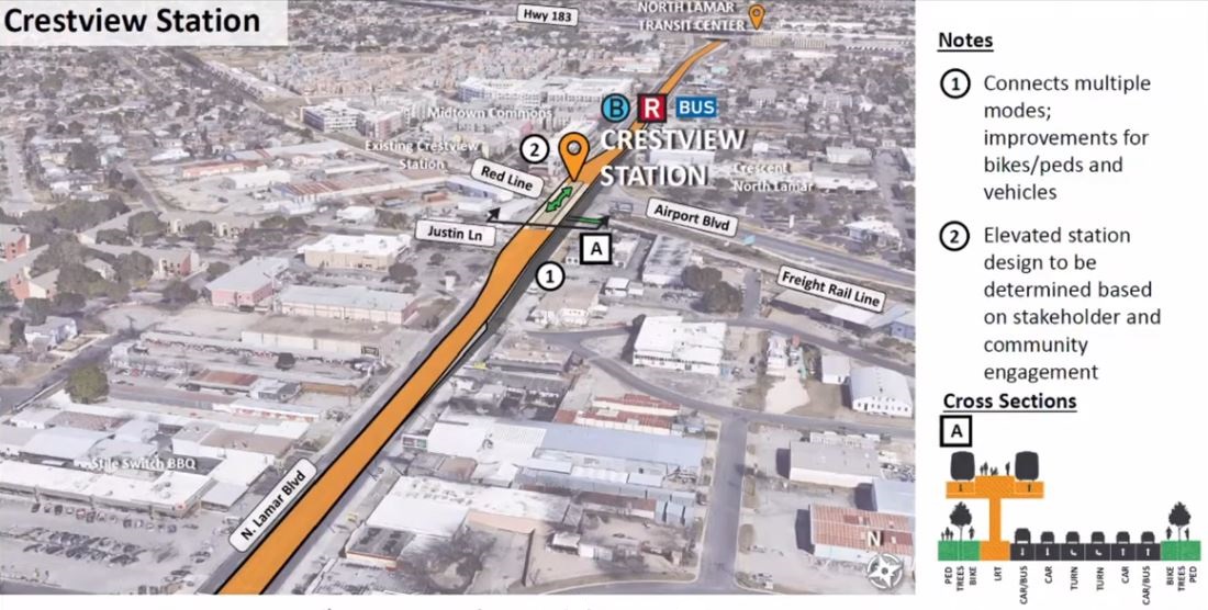
Converting the MetroRail Red Line to electric LRT, and incorporating a connection in the grade-separation already being planned at Crestview, would be a relatively moderate-cost project, much less than building a new line from scratch. On average, using and modifying an existing railway alignment provide by far the lowest-cost type of LRT line construction. Planning for an integrated LRT system including the northwest line to Leander would need planning for both design and funding.
In terms of design, two engineering features are necessary:
• Plans for the grade-separated interchange at Crestview (N. Lamar/Airport Blvd.) would need to be modified to include a future track junction to enable northwest-corridor trains to join and interline with the Orange/Blue Line tracks on North Lamar. As currently planned, both rail alignments would be separated from the North Lamar roadway lanes; but a total grade separation is also planned between the existing railway (Red Line, which would tunnel under the intersection), and Project Connect’s proposed LRT alignment (which would fly over the intersection on a viaduct). This would force a cumbersome transfer for all LRT passengers traveling to or from the northwest and points south. A track junction would facilitate interlining and enable the seamless, transfer-free ride described earlier.
Diagram illustrates current design (15% complete) of future Orange Line LRT entering elevated alignment on North Lamar at Crestview, with Red Line totally grade-separated and crossing below LRT in tunnel (freight track would remain at-grade). To link northwest corridor into LRT system, this design must be modified to include track junction between Red Line and Orange Line. Graphic: Project Connect (click to enlarge).
• LRT system rail and vehicle wheel profiles that conform with railroad specifications would need to be designed and selected (i.e., the rails and car wheel profiles for the new LRT system would need to match those currently in use for the Red Line). This is standard for transit systems that include track-sharing with heavy railroad operation.
However, it must be realized that Project Connect’s planners are moving quickly toward finalizing a two-tier separated MetroRail and LRT dichotomy permanently in their final design, now 15% completed in late 2021 and expected to be 30% completed in the spring of 2022. Unless that design is tweaked to include the unification and compatibility measures described in this report, residents in the northwest corridor, including Leander, would likely never have that one-seat ride to UT, the Capitol, and ABIA, and Capital Metro’s rail transit services would be burdened with higher-than-necessary O&M costs.
The inclusion of the northwest corridor, and conversion of the Red Line to LRT, are not part of the large Project Connect transit program approved by voters in November 2020 and now underway. These plan changes would need to be approved, funded, and undertaken as a future separate project. This would include negotiating for and receiving a track-sharing waiver from the Federal Railroad Administration (as was done in San Diego and Salt Lake City). But surely the multiple benefits and substantial cost savings justify investing the effort and resources to achieve a unified regional LRT system for metro Austin. ■
Austin metro area is a regional area and needs a complete, comprehensive, fully interlined regional electric light rail system for adequate, cost-effective mobility. Map: ARN, from Google Maps.
♦
By Lyndon Henry
The following statement by Lyndon Henry, a technical consultant to the Light Rail Now Project and contributing editor to Austin Rail Now (ARN), was presented as part of Public Comment by phone on 7 August 2020 to a joint meeting of the Austin City Council and Capital Metro Board considering approval of an Interlocal Agreement and incorporation measure to implement a proposed Austin Transit Partnership to manage the proposed Capital Metro/Project Connect multi-modal transit system expansion project. The $7.1 billion multi-modal transit system plan, with two initial light rail lines, will be presented on the ballot for voter approval as Proposition A in the upcoming election on 3 November 2020. (The complete Project Connect long-range plan includes three eventual light rail lines as well as other regional rail services and various bus-based services.)
I’m Lyndon Henry. I’m an urban planner and transportation planning consultant, a former Capital Metro Board member, and a former data analyst for Capital Metro.
The Project Connect plan, centered on an urban rail system and anchored by a light rail spine along the key North Lamar-Guadalupe-South Congress Orange Line corridor, would basically implement the mass transit vision I’ve been advocating for the past 49 years. In pursuit of that vision, I participated in creating Capital Metro, served four years on its board, and later worked for the agency for nine years.
Starting in the 1970s, I initiated an effort to acquire, for rail transit use, the former Southern Pacific Railroad branch line from Giddings to Llano, the western part of which is in operation today as the Metrorail Red Line. I’ve also been continuously active over four decades as a community participant in the urban rail planning process, including Project Connect.
From its inception Capital Metro was conceived as a regional system with rail transit to serve both suburban and central-city neighborhoods of the Austin metro area. The Project Connect plan, with its three light rail lines, can be a major step toward fulfilment of that original intention to connect Austin’s more outlying neighborhoods with one another and the central city.
Expanding electric light rail is crucial to that regional vision. This can be done relatively easily and cost-effectively.
First, the Metrorail Red Line and proposed Green Line can be converted to faster, more cost-effective, high-capacity electric light rail service for the northwest and eastern sections of the metro area..
Second, the former Katy railroad right-of-way is a natural alignment to link eastern and northeastern suburbs and communities into central Austin.
Third, in south and southeast Austin, the former Bergstrom spur right-of-way offers an excellent route for an additional light rail line directly linking the ABIA airport with the Union Pacific rail corridor, South First St., the South Congress Transit Center, and neighborhoods east of I-35 along the Ben White/US 71 corridor.
I strongly support approving the Interlocal Agreement and incorporation measure to implement the proposed Austin Transit Partnership, and the funding commitments, toward the goal of building the regional highspeed electric light rail network that Austin has needed for so long.
■
Simulation of Austin light rail alignment in roadway median. Graphic: Project Connect.
♦
Commentary by Lyndon Henry
The following statement by Lyndon Henry, a technical consultant to the Light Rail Now Project and contributing editor to Austin Rail Now (ARN), was presented as part of Public Comment by phone to a joint meeting of the Austin City Council and Capital Metro Board on 10 June 2020. Subsequently, Project Connect’s plan for a $7.1 billion multi-modal transit system expansion, including two initial light rail lines, has been approved by the Austin City Council and scheduled as a ballot measure for the upcoming election on 3 November 2020.
I’m Lyndon Henry. I launched the concept of light rail transit for Austin with a feasibility study back in 1973. Over the past 47 years I’ve worked to make this crucial public transport system a reality.
As I’ve long pointed out, light rail has unique potential, as a more affordable high-capacity urban rail mode, to attract ridership, provide more cost-effective operation, stimulate transit-oriented development, galvanize the entire transit system, create a more livable urban environment, and mobilize community support.
At last, decades of effort by the City of Austin and Capital Metro, particularly Project Connect, have brought us to today’s monumental plan, centered on light rail with a central spine along the key North Lamar-Guadalupe-South Congress Orange Line corridor as its anchor.
This massive public-works project will provide jobs and help rebuild Austin’s economy when we finally emerge from the pandemic nightmare. Light rail will open exciting possibilities for catalyzing development in the Core Area, especially around the massive proposed subway infrastructure, as well as elsewhere along other corridors. This will provide crucial economic stimulus to create more jobs as well as expand critical taxbase and fund further service improvements.
Thinking well into the future has been a hallmark of Project Connect’s ambitious planning, preparing for future urban growth and transit capacity needs. This critical foresight must be continued with a view to eventual conversion of the Red Line to light rail transit.
The northwest corridor, paralleling US 183, definitely ranks among the heaviest travel corridors in our metro area. Converting the Red Line to more efficient electric light rail would provide huge service improvements, improve cost-effectiveness, and stimulate much higher ridership, especially by offering seamless, transfer-free travel from northwestern communities into Austin’s core. This would also extend electric light rail service to benefit East Austin neighborhoods.
This future improvement needs to be prepared for now, by designing appropriate infrastructure features into the planned Crestview intersection grade separation
I want to thank all of the diverse team involved with Project Connect for listening to so many of us in the community in developing this plan. It is certainly heartening and refreshing to see the results of this long saga of planning and to be able to support such an ambitious and exciting project.
I urge you to designate this plan as Austin’s Locally Preferred Alternative. Thank you.
Map and graphics from Project Connect’s Feb. 2018 proposal illustrates possible 12-mile initial light rail line from Tech Ridge (at left end of map) routed south down N. Lamar-Guadalupe corridor to Republic Square in CBD (map is rotated 90°, with north to left and south at right). Other graphics show alignment design options and station attributes. Yet Capital Metro leadership has now withdrawn plan and restarted study process for another two years. Graphics: Project Connect.
♦
by Lyndon Henry
This post is a publication of comments made by Lyndon Henry to the Austin City Council on 13 December 2018. Henry is a technical consultant to the Light Rail Now Project and a contributing editor to the Austin Rail Now website.
For decades, Austinites have been suffering the agonies of a worsening mobility crisis. Help has never been far away – over the past 30 years, no less than six official studies have come to the same conclusion: light rail transit, interconnected with an extensive bus network, is what’s needed.
But time after time, Austin’s leadership has failed to bring a single one of these plans to successful fruition. Austin has become the national poster child of analysis paralysis.
And now Capital Metro and its Project Connect planning program have restarted us on another re-iteration of this same exhausting process for a seventh time and another two years.
Transit advocates appreciate that Capital Metro has revised its Vision concept by restoring light rail and some additional corridors. But much more is needed.
Instead of backsliding to zero again, Capital Metro and the City of Austin need to fast-track this process by building on the data, analysis, community input, and other resources that have already recommended a light rail system and enhanced bus network as the way out of our mobility quagmire.
The Vision plan needs to become a lot more visionary. It needs to preserve a lot more corridors for future dedicated transit lanes. It needs to envision more and longer routes reaching out to serve other parts of the urban area.
Light rail can make this possible. It’s an affordable, cost-effective, off-the-shelf electric transport mode that’s well-proven in hundreds of cities and, best of all, it’s here today – we don’t have to wait for some science fiction technology. Austin needs a solution that’s available now.
Urban light rail is the crucial linchpin of a mobility plan because it has the power to make the whole system work effectively. It’s shown it has the true capacity to cost-effectively handle and grow Austin’s heaviest trunk routes, freeing up buses and resources to expand service into many more neighborhoods citywide. This advantage is validated by solid evidence – in average ridership and cost-effectiveness, cities with urban rail have significantly outpaced cities offering bus service only.
Yet even before Study No. 7 has begun, some Capital Metro and other local officials have been hinting they favor bus rapid transit (BRT) – basically a repackaging of bus service with minimalist capital improvements and lots of fanfare. But it’s unlikely BRT will provide the breakthrough Austin so desperately needs.
On average, compared to BRT, new light rail systems are carrying over three times the ridership at 10% lower operating cost. They’ve shown they can spark adjacent economic development and help shape urban density and growth patterns. BRT has shown almost no such benefits. And light rail comes without the toxic pollution and other problems of rubber tires.
Let’s leave the paralysis behind, and put a light rail starter line on a fast track for a vote in 2020.
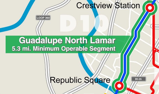
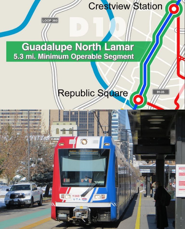
An even more affordable light rail starter line project has been proposed by Central Austin Community Development Corporation as a 5.3-mile Minimum Operable System extending from the Crestview MetroRail station (at N. Lamar/Airport) to Republic Square. For a surface alignment with no major civil works, estimated cost in 2016 was less than $400 million. Graphic: CACDC.
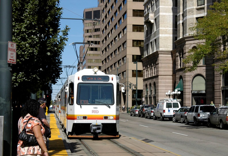
Top: Map of Guadalupe-Lamar light rail starter line minimal operable segment (MOS), proposed in 2016. (Map: CACDC.) Bottom: Salt Lake City light rail line at downtown station could resemble system proposed for Austin. (Photo: L. Henry.)
♦
by Lyndon Henry
This post has been adapted from comments distributed to members of the Multimodal Community Advisory Committee (MCAC) at its meeting of 26 April 2017. Lyndon Henry is a technical consultant to the Light Rail Now Project and a contributing editor to the Austin Rail Now website.
► Affordable — Especially for cities of Austin’s size, light rail has typically demonstrated an affordable capital cost and the lowest operating + maintenance cost per passenger-mile of typical urban transit modes. http://www.vtpi.org/bus_rail.pdf
► Urban benefits — In contrast to bus operations, light rail systems have demonstrated a consistent, significant propensity to attract adjacent development, stimulate economic prosperity, and help shape and guide a changing urban landscape. http://www.lightrailnow.org/industry_issues.htm#urban
► Capacity — Compared to both buses and “gadget” modes like gondolas, LRT has far higher capacity in normal service scenarios and greater capability to accommodate future demand. Unlike many “gadget” alternatives, LRT is well-proven in public service, a readily available technology, and non-proprietary. https://www.thoughtco.com/passenger-capacity-of-transit-2798765
► Expandable — The lower capital cost of a predominantly surface LRT system makes it the ideal affordable mode for future expansion of a rail transit network throughout the Austin metro area.
Why the Guadalupe-Lamar corridor?
► Travel density — Guadalupe-Lamar (G-L) is center city’s 3rd-heaviest north-south corridor. The City of Austin (COA) has repeatedly emphasized that G-L is the primary local traffic corridor in central-city Austin, with exceptionally heavy traffic at maximum capacity for over the past 2 decades. Texas Transportation Institute ranks North Lamar as one of the most congested arterials in Texas. Urban rail is essential to maintaining mobility in this crucial corridor. It’s the most logical location for an urban rail starter line. https://austinrailnow.com/2014/10/13/latest-tti-data-confirm-guadalupe-lamar-is-central-local-arterial-corridor-with-heaviest-travel/
► Employment & population density — With Austin’s highest total employment density on Guadalupe-Lamar, an urban rail line could serve 31% of all Austin jobs. Since, this corridor also has Austin’s highest population density, an urban rail line would serve the highest-density residential concentrations in the city – including the West Campus, ranking as the 3rd-highest neighborhood in residential density among major Texas cities. http://centralaustincdc.org/transportation/austin_urban_rail.htm
► Future expansion — As Austin’s primary central arterial access corridor, Guadalupe-Lamar is ideally positioned to become the spine and anchor for future expansion of LRT into an eventual citywide system.
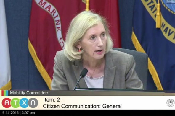
Ann Kitchen chairs City of Austin Mobility Committee meeting of June 14th. Photo: Sceenshot from ATXN video.
♦
By Lyndon Henry
The following comments were made during Citizen Communications to a public meeting of the City of Austin’s Mobility Committee on 14 June 2016. Lyndon Henry is a transportsation planning consultant, a former board member of Capital Metro, a technical consultant to the Light Rail Now Project, and a contributing editor to this website.
I urge you to include a measure for urban rail in the proposed $720 million “mobility” bond package now under consideration. I support the proposal for an affordable 5.3-mile light rail Minimum Operable Segment on North Lamar and Guadalupe from Crestview to downtown.
Currently 83% of the proposed $720 million package is devoted to road projects. Surely some of these road projects could be replaced with the $260 million to $400 million that would facilitate an urban rail project.
Proposed 5.3-mile light rail transit starter line Minimum Operable Segment in Guadaluoe-Lamar corridor. Graphic: CACDC.
It’s absurd that the $720 million bond package you’re considering could be labeled a “mobility” package despite NO major initiative for transit, let alone urban rail, which has been studied and affirmed as a necessity for decades. This bond proposal stands in contradiction to the decades of official “green” rhetoric and policy initiatives such as Envision Central Texas and Imagine Austin that have verbally embraced public transportation and “high-capacity transit” as key “alternative mobility” measures necessary to “keep Austin moving”.
This road-focused $720 million package tries to address congestion by increasing “throughput” of vehicles. Unfortunately, experience and evidence suggest that this is a losing approach — trying to tweak more capacity to squeeze through more cars typically just induces more traffic. Furthermore, this influx of ever-growing vehicle traffic imposes more stress on congested areas such as Austin’s core.
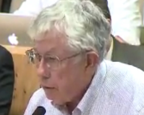
Lyndon Henry presenting comments to City of Austin Mobility Committee on June 14th. Photo: Screenshot from ATXN video.
In contrast, this light rail plan (and future expansions throughout Austin) removes traffic from roadways by attracting motorists to the transit service, adding the equivalent of four lanes of extra peak capacity to this corridor. Can the same be said for the current $720 million road-focused bond plan?
I suggest that urban rail — providing highly attractive rail transit service on its own dedicated tracks — makes far more sense as a solution for alleviating mobility congestion, than simply trying to squeeze more traffic onto the city’s crowded streets, roads, and parking spaces.
I’ve heard the argument that urban rail is “not ready” to be offered as a bond measure. Yet polls and other evidence indicate resounding support for public transit and urban rail, and the Austin community has gone through years of repeated outreach exercises familiarizing them with the technology and the issues. The public seems more ready than ever to support rail; it’s Austin’s civic leadership that seems to have cold feet.
Finally, whatever bond package you choose, I urge you to unbundle the roads bonds from the small proportion of bicycle and pedestrian bonds. This would allow the community at least to consider these alternative mobility elements separately. ■
[
NOTE: As of this posting, the Mobility Committee and City Council have approved the $720 million roads-dominated bond measure, without provision for transit, as a bundled package.
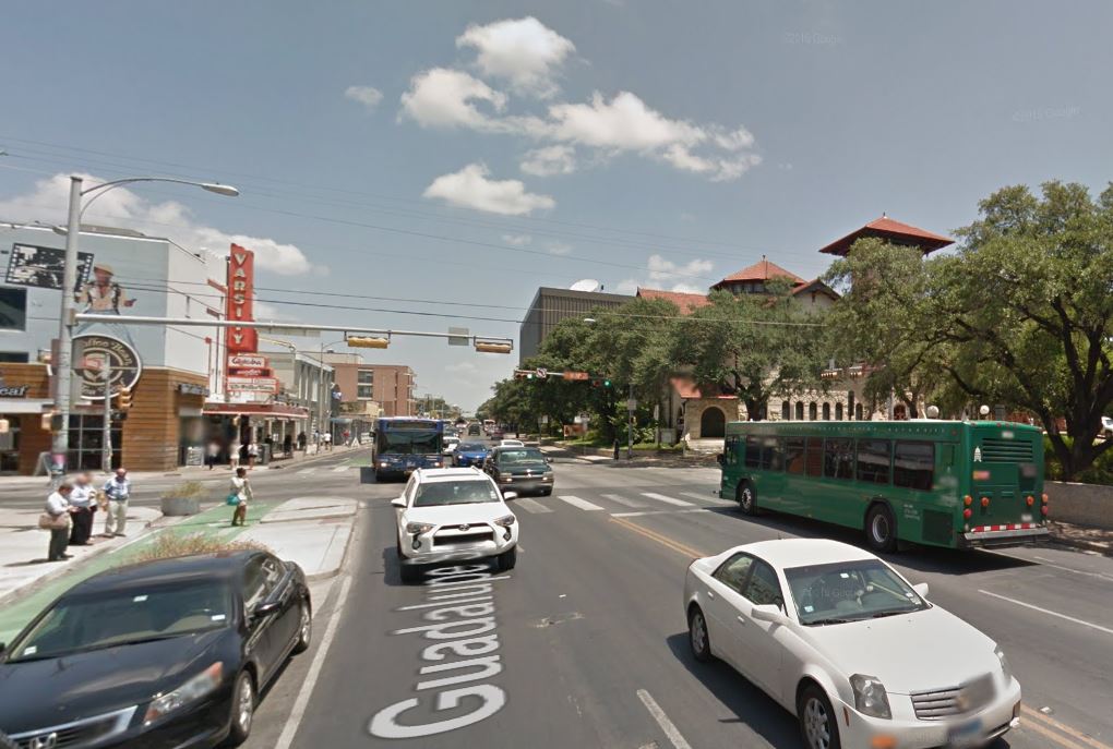
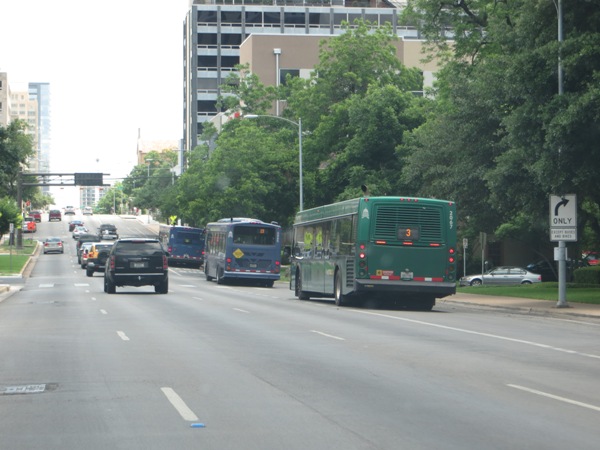
Busy section of Austin’s Drag, Guadalupe St. at W. 24th St. Official city planning by CTR has proposed curbside transit lanes, with buses running on outside lanes as seen in this photo. (Screenshot from Google Streetview.)
♦
By Lyndon Henry
The following commentary has been adapted and expanded from remarks posted to an online Austin rail discussion. Lyndon Henry is a transportation planning consultant, a technical consultant to the Light Rail Now Project, an online columnist for Railway Age magazine, and a contributing editor to Austin Rail Now. He is also a member of the Light Rail Technical Forum and Streetcar Subcommittee of the American Public Transportation Association (APTA). His comments highlight the vision of Austin Rail Now and other transit advocates that light rail is justified in, and needs to be planned for, a number of the Austin area’s major travel corridors.
Map shows the Drag area (Guadalupe St., running north-south in center). UT campus lies on the east, West Campus neighborhood on the west. (Screenshot from Google Maps.)
Now, driven partly by their fixation to substitute buses for rail as “rapid transit”, and partly by pressure from some community groups and activists, local civic leaders and official planners are floating plans for dedicated transit (read “bus”) lanes on the Drag. (Official planning defines “the Drag” as continuing north to W. 29th St.)
Last month (August 2015), AURA (originally Austinites for Urban Rail Action), a grouping of mostly Millennial-aged urban planning enthusiasts, posted a proposal for major improvements on the Drag, one of which suggested: “Extend transit priority lanes from Downtown to the Drag”.
At peak periods, transit moves roughly half of the people passing through the corridor. This is to be expected in a central location like the Drag, as transit is by far the most efficient way to move people in a city.
Given the anticipated growth of the city, increasing the throughput of people in the corridor is of paramount importance. The city should plan ahead for increased frequency of existing bus routes, and continue to examine the viability of Guadalupe as a future corridor for rail service. Buses should not have their effectiveness limited by less efficient forms of mobility. Two lanes of Guadalupe should be dedicated solely to transit.
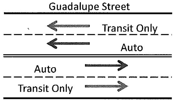
Back in May, per its contract with the City of Austin (COA), UT’s Center for Transportation Research (CTR) produced for city staff a memo of its findings with respect to installing dedicated lanes on the Drag. As summarized by AURA’s John Laycock, the report “modeled three scenarios: Scenario 0) the baseline scenario, Scenario 1) a transit lane in each direction on Guadalupe, and Scenario 2) diverting the buses completely off of Guadalupe onto San Antonio.” Laycock reports that the city subsequently requested CTR to model an additional case, involving one transit lane northbound on Guadalupe and another southbound on Nueces/San Antonio. Results from that additional modeling effort apparently have not yet been released publicly.
Diagram from CTR report for curbside dedicated lanes on the Drag. (Screenshot from CTR memo.)
The proposal for dedicated transit lanes on the Drag may seem fairly benign, helpful to public transport and innocuous to the prospects for light rail (LRT). However, installing reserved transit lanes without broader planning for rail can raise some quite serious problems. Depending on their design and implementation, transit lanes could significantly improve or seriously impede the prospects for light rail transit (LRT) — by far, the most feasible and affordable rail option — in the Guadalupe-Lamar corridor. (See «Plan for galvanizing Austin’s public transport development: Light rail starter line in Guadalupe-Lamar».)
First, I’ll note that implementing a high-quality bus service as a precursor to rail can be an effective way of building ridership and preparing the public for the coming rail upgrade. Likewise, establishing reserved transit lanes that can be dedicated to rail can also be helpful. However, both infrastructure and configuration of dedicated transit lanes, done improperly, can create problems.
• Infrastructure — Proponents of dedicated transit lanes have argued that all that’s needed is to paint some stripes on the street. And certainly, in the scheme of transit capital projects, just “painting” markings on pavement is relatively cheap. But there’s almost always more involved. The Guadalupe-Lavaca transit lanes, for example, included repaving, plus bus stop relocation and upgrading. Parking meters were removed. And the project has resulted in effectively eliminating the possibility of dedicated LRT tracks on those sides of these streets (bus traffic too heavy).
Buses use curbside reserved lanes on one-way Lavaca St. downtown. Curbside lanes on the Drag would be similar, but on two-way street. Photo: L. Henry.
In previous discussions I’ve suggested that LRT dedicated lanes would need to be relocated on the opposite side of each street. Total cost of the downtown bus lane project was about $370,000 — not a billion-dollar investment, but enough of an investment certainly to give pause to totally redoing this project, or making substantial modifications to it (although modification to add LRT would definitely be a highly worthwhile investment).
We also don’t know what COA and Capital Metro have in mind for the Drag project. Some community transit activists might be thinking very minimalist, but what are official planners thinking?
• Configuration — The precise alignment on the transit lanes also needs serious consideration with respect to the needs of LRT (and evidence suggests that a substantial portion of the Austin community would like to see LRT as a project on the planning table now). Curbside lanes — as assumed in the CTR design, described above — are used by several major LRT systems (Portland, Houston, Dallas, and Denver come immediately to mind), but this configuration can often encounter serious problems, mainly with motor vehicle right-turns and especially pedestrian traffic (including where the right turns are made). Another problem for the Drag is the number of driveway cuts and the issue of access to businesses along this commercial alignment.
Denver: Passengers waiting to board LRT train running in curbside lane on Stout St. Photo: Peter Ehrlich.
To be sure, a number of different LRT alignment and configuration options are possible. My preferred alignment concept for the Drag has been to keep both LRT tracks on Guadalupe, in the center (with stations also in the center), and the outside (curb) lanes continued for mixed motor vehicle traffic, including buses. The main reason for this configuration is that buses need access to right-side loading at stops, and I envisioned that local routes like #1 would need to be continued. Of course, bus routes could be moved further west, probably to San Antonio-Nueces, but keeping them on Guadalupe would facilitate relatively easy transfers to and from LRT and bus.
Ideally, the main Drag segment in this heavy-pedestrian/heavy-transit traffic area should be converted to a pedestrian-transit mall, with general motor vehicle traffic prohibited (except perhaps in the case of service vehicles for adjacent businesses). However, a design with reserved transit lanes plus a single mixed-traffic lane in each direction would appear to be possible.
To sum up: While dedicated transit lanes, with very minimal investment, could possibly be helpful as a preparation for LRT, I’d recommend huge caution and vigilance as this notion moves forward. Keeping particularly in mind the considerations I’ve raised above.
In this regard, it’s important to realize that a major chunk of Austin’s civic leadership, and planning establishment, still regard MetroRapid as the city’s “rapid transit system”. Likewise, the fantasy persists that Austin could “become the best bus system we can be” without a rail system. (Cities with the “best bus systems” also seem to happen to have excellent rail systems too.) Reserved transit lanes on the Drag could advance the case for LRT, but only if they’re properly configured, designed, and planned in the context of an ultimate LRT outcome. ■
The following comments, adapted here to webpage format, were distributed to attendees at a public event sponsored by the City of Austin’s South Lamar Boulevard Corridor Study project on 10 December 2014. Lyndon Henry is a transportation planning consultant, a technical consultant to the Light Rail Now Project, and a contributing editor to Austin Rail Now. His comments highlight the vision of Austin Rail Now and other transit advocates that light rail is justified in, and needs to be planned for, a number of the Austin area’s major travel corridors.
► South Lamar light rail transit line makes sense
• In terms of both travel density and traffic congestion, South Lamar Blvd. ranks high among Austin’s major travel corridors (see Latest TTI data confirm — Guadalupe-Lamar is central local arterial corridor with heaviest travel). Current travel density plus rapidly increasing population density plus commercial growth in this corridor all indicate that planning for light rail transit (LRT) should long since have been under way.
• A South Lamar surface LRT line, possibly using an alignment design such as is illustrated below, needs to be a major part of an eventual citywide system branching north, south, east, and west throughout our region from an initial central spine in the Guadalupe-North Lamar corridor.
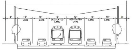
Cross-sectional diagram showing how center LRT reservation could be inserted in South Lamar, maintaining traffic lanes and sidwalks. Design would use side-mounted traction electrification system poles for suspending the overhead contact system for LRT electric propulsion. Graphic: ARN. (Click to enlarge.)
• The South Lamar Corridor Improvement Program should be reconfigured to include planning for LRT as a crucial focus of this project. Planners and traffic engineers need to ensure that any “improvements” in this corridor facilitate dedicated transit lanes for future light rail, and certainly should not impose obstacles to it. It’s way past time to scrap the practice of proceeding with major projects with little if any thought to the future.
► Form a Community Policy & Technical Oversight Committee
• Planning should involve the Austin community as a whole, and this means forming a broad, inclusive community committee to oversee policy and technical decisions, including a comprehensive transit-focused mobility plan for Austin and its surrounding region. No more secretive project teams meeting in a virtual “bunker”, then emerging to tell us what they’ve decided for us! Authentic public participation means including representatives of neighborhood and other community groups, plus others with applicable expertise within the Austin community at large.
Current view of traffic and urban development on South Lamar. Photo: Austin Mobility.
► Dedicate street lanes for light rail transit
• Light rail can carry many more peak passengers than private cars, and attract many more riders than buses (both “regular” and MetroRapid). Austin needs to start re-allocating street space from traffic lanes to transit lanes, and the South Lamar corridor must be included. Smart design could install LRT in this corridor while retaining at least 4 lanes of traffic (see diagram in first section, above). ■
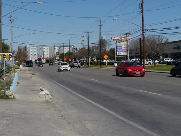
Guadalupe St. at W. 24th St., looking south. The Drag, passing one of the densest residential neighborhoods in Texas and busy commercial district, is major segment of high- travel-density Guadalupe-Lamar corridor. Photo: Google Maps Streetview.
♦
By Lyndon Henry
The following comments, adapted here to webpage format, were distributed to a public event sponsored by the City of Austin’s Guadalupe Transportation Corridor Project on 3 December 2014. Lyndon Henry is a transportation planning consultant, a technical consultant to the Light Rail Now Project, and a contributing editor to this website.
► Guadalupe-Lamar light rail transit starter line makes most sense
• A light rail transit (LRT) starter line for the Guadalupe-Lamar (G-L) corridor has been studied for 40 years, with at least $30 million invested. (Source: AustinRailNow.com) This is a plan that makes sense, and it’s time to move forward with it!
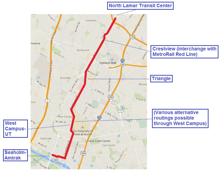
• G-L is Austin’s most central north-south corridor, with by far the heaviest travel and congestion. A starter line from the North Lamar Transit Center to downtown, serving this busy corridor, established neighborhoods, the high-density West Campus, the Capitol Complex, and the central business district, with a branch to the Seaholm-Amtrak development area, is estimated to carry 30,000-40,000 rider-trips a day. (Source: AustinRailNow.com)
6.8-mile starter line, proposed by Austin Rail Now, could launch electric LRT service in the Guadalupe-Lamar corridor for less than $600 million. Proposal includes dedicated lanes for rail, 4 traffic lanes, and sidewalks. Map: ARN. (Click to enlarge.)
• A surface starter line like the one shown at left (6.8 miles) could be installed for less than $600 million. With affordable, cost-effective design, this would become the central spine of an eventual citywide system branching north, south, east, and west throughout our region.
• The Guadalupe Transportation Corridor Project should be reconfigured to focus on development of this long-deferred LRT project, along with the $2.5 million of previous funding for the now-defunct Highland-Riverside urban rail plan, now held by Capital Metro. Re-purpose urban rail planning to focus on light rail transit for G-L!
► Form a Community Policy & Technical Oversight Committee
• Planning should involve the Austin community as a whole, and this means forming a broad, inclusive committee to oversee policy and technical decisions. No more secretive project teams meeting in a virtual “bunker”, then emerging to tell us what they’ve decided for us! Authentic public participation means including representatives of neighborhood and other community groups, plus others with applicable expertise within the Austin community at large.
► Dedicate street lanes for light rail transit
• Light rail can carry many more peak passengers than private cars, and attract many more riders than buses, MetroRapid included. Austin needs to start re-allocating street space from traffic lanes to transit lanes, and G-L is the ideal corridor to start in! Smart design could install LRT in this corridor while retaining at least 4 lanes of traffic for most of the route. For more information, check out: http://austinrailnow.com
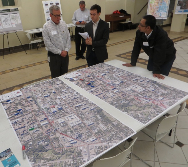
At Dec. 3rd Guadalupe Transportation Corridor Project public event, project manager Alan Hughes (center, in checkered shirt) discusses project issues over table with Drag corridor maps. At far right in photo is Roberto Gonzalez of Capital Metro’s Planning Department. Photo: L. Henry.
Project Connect map (annotated by ARN) showing half-mile radius from proposed urban rail stations. Except for a mainly commercial and retail sliver along the Drag, most of high-density West Campus residential neighborhood is beyond station access radius.
♦
By Lyndon Henry
The following comments were made during Citizen Communications to Project Comnnect’s Central Corridor Advisory Group (CCAG) on 13 June 2014 regarding Project Connect’s proposed 9.5-mile, $1.4 billion urban rail starter line connecting East Riverside (southeast) with the Highland ACC site now under development (north). Ultimately, the group voted to recommend Project Connect’s proposal to the City Council.
Since 2006, UT has insisted on a San Jacinto route that would bolster its development aims for the East Campus. However, the West Campus is where the people are, with the third-highest residential density in Texas. It’s where the heavy travel flow is, and where most activity is clustered. And the FTA-required half-mile demographic “watershed” around proposed urban rail stations on San Jacinto barely touches the eastern edge of the West Campus. (See map at top of this post.)
Meanwhile, although insisting that its East Campus development program must be served by Austin’s urban rail, the UT administration has not offered a dime to fund it. Instead, they’ve happily assumed that Austin taxpayers can obligingly be squeezed with higher property taxes to pay for this amenity.
There’s a “reverse-Robin-Hood” aspect to this. Because of shale oil extraction on Permanent University Fund lands, according to a San Antonio Express-News report last year, “The University of Texas System is rich. … Oil is the reason why.”
The UT system is awash in money to the tune of a billion dollars a year, boosting UT Austin’s share to a total of nearly $200 million. Profits from football and other athletic entertainment bring in another $78 million a year.
While there are certainly various needs for this money — particularly the need to keep tuition costs affordable — and some constraints on how it’s used, it would seem logical and fair that, if UT desperately wants urban rail in the relatively less dense, less active San Jacinto route, UT should dip into its own resources to pay for it.
An East Campus-Medical School alignment could be installed as a branch from the Guadalupe-Lamar alignment proposed as an alternative to Project Connect’s plan. UT could cover the $45 million local cost in five years by modest annual dollops of $9 million from its abundant revenues.
This compromise alternative could buttress the feasibility of urban rail and increase the benefit to the entire Austin community. But UT’s administration needs to stop trying to soak Austin taxpayers, and take responsibility for funding its fair share of what it wants.
The following comments were made during Citizen Communications to the City of Austin’s Urban Transportation Commission on 10 June 2014 regarding Project Connect’s proposed 9.5-mile, $1.4 billion urban rail starter line connecting East Riverside (southeast) with the Highland ACC site now under development (north). In the end, the commission voted, with minor amendments, to recommend Project Connect’s proposal to the City Council.
There are three huge problems with Project Connect’s proposal:
(1) It spends $1.4 billion to put urban rail in the wrong place.
(2) It will hinder and constrain future rail development.
(3) A vote for this flawed plan is also a vote to permanentize lower-capacity MetroRapid bus service in our strongest, densest travel corridor, Guadalupe-Lamar.
Guadalupe-Lamar is the outstanding corridor to start urban rail — among the top heavy travel corridors in Texas, a long-established commercial district, with major activity centers, the city’s core neighborhoods, and the West Campus, having the 3rd-highest residential density in Texas.
In contrast, Project Connect proposes to forsake the central city’s heaviest and densest local corridor and instead connect a weak corridor, East Riverside, with a non-existent travel corridor through the East Campus, Hancock, and Highland. By wasting over a billion dollars on urban rail in this meandering, misguided route, Project Connect will divert scarce funds from future rail development.
Project Connect’s Riverside-East Campus-Hancock-Highland plan comes “gold-plated” with a new $130 million “signature bridge” over the river and a $230 million tunnel at Hancock. But it runs in mixed street traffic from UT to Hancock. This is a proposal that costs too way much for too little value.
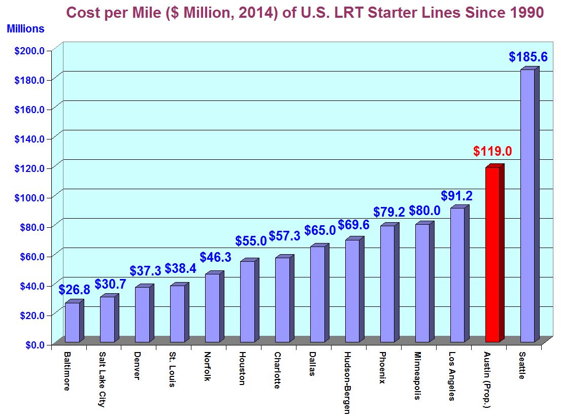
And it’s the third most pricey urban rail starter line, by cost per mile, in U.S. history. City officials now routinely propose a major property tax increase to finance the local share of Project Connect’s plan.
Per mile of route, proposed Highland-Riverside urban rail plan would be second most expensive light rail starter line since 1990, and third most expensive in U.S. history. Graph: ARN. (Click to enlarge.)
Voting for Project Connect’s urban rail plan for East Riverside to Highland also means voting to pour concrete for bus lanes and other bus facilities on Guadalupe and Lamar that will prevent an urban rail alternative in our heaviest, neediest corridor for decades. The current MetroRapid bus service on Guadalupe, Lamar and South Congress carries 6,000 daily riders, less than one-eighth of the 51,000 forecast for light rail in that same corridor.
According to a report yesterday from a private meeting of urban rail “stakeholders” at Capital Metro, representatives of both Project Connect and Capital Metro admitted that Phase 1 of this project, which conjured up Looney-Tunes voodoo and passed it off as “scientific” projections, was “too fast and not at a pace they would typically have proceeded.”
In contrast to major rail planning in the past, the public has basically been cut out of this process. Now Mayor Leffingwell and his administration announce they’re tossing in a dollop of road projects that even some councilmembers criticize as failing to fit into the Imagine Austin concept of a walkable, dense city. In effect, they’re packaging a dubious, wasteful rail project with questionable road projects, and wrapping a “congestion relief” ribbon around it.
This is a planning process that’s gone off course and out of control. This commission needs to do the right thing, and say as much to the city council. ■
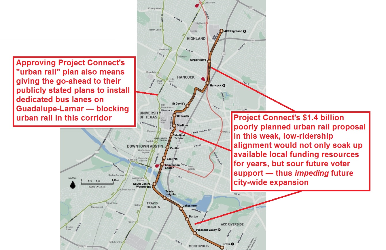
Project Connect’s “urban rail” plan would not only absorb vast local financial resources, but would install “dedicated bus lanes” as an obstacle to urban rail where it’s actually most needed — in Guadalupe-Lamar. Graphic: Adaptation by ARN from Project Connect map. (Click to enlarge.)
♦
By Dave Dobbs and Lyndon Henry
For weeks now, Project Connect (with public tax money) has been carrying out a “saturation bombing” ad campaign promoting its $1.4 billion urban rail plan, primarily aimed at bolstering development plans and centered on the interests of private developers and the East Campus expansion appetites of the University of Texas administration.
It’s a “Pinocchio-style” campaign (and plan) packed with exaggerations contrived to try to sucker voter support. Perhaps the worst problem is the “city-wide system” deception that Project Connect is pushing in its ad blitz — the make-believe that an urban rail line on East Riverside through the East Campus to Highland will lead to rail in other parts of the city.
In fact, just the opposite will happen. The staggering cost will soak up available local funding for years to come — and that in itself will impede future rail transit development.
The “Elephant in the Road” — a vote for Project Connect’s Highland-Riverside “urban rail” project is also a vote for a bus project on Guadalupe-Lamar that will block urban rail where it’s most needed. Image: ARN library.
Once they spend $28 million a mile for bus lanes using 80% federal grants (as stated in official plans) we’ll have to live with that investment for two to three decades. Essentially Guadalupe-Lamar, South Congress, and South Lamar, streets that need rail to handle the potential passenger volumes, will end up with MetroRapid in dedicated right-of-way with an automobile lane and perhaps a bike lane in each direction. Instead of buses being seen as shuttles to good city-wide train service, buses will continue to be seen, as former State Highway Engineer DeWitt Greer once expressed it, as suitable only for “a certain class of people” and a nuisance “in the way of my car.”
Austin has waited a long time for an urban rail system — but it’s far better to wait a bit longer to do it right than to rush into a plan (which includes flawed roadway projects as well) just because it’s “rail”. A plan that impedes good transit development and future system expansion is worse than nothing. ■
I-35 is the most congested roadway in Texas. But is this really the main travel corridor for commuters from “Highland-Riverside” neighborhoods to the Core Area? And would Project Connect’s proposed urban rail line have any perceptible impact? Photo source: KVUE-TV.
♦
By Dave Dobbs and Lyndon Henry
Lately, Project Connect representatives have been trying to claim that their meandering urban rail route proposed from Highland, through Red River and San Jacinto, to East Riverside, somehow addresses the problem of congestion on … I-35.
Really?
Leaving I-35 at the Highland site to ride a slow train to downtown doesn’t make any sense when, at Highland ACC, you are almost at the Core Area. By the time you leave the freeway, park your car, walk to the station, wait for the train, and ride downtown, you might as well have stayed on the freeway.
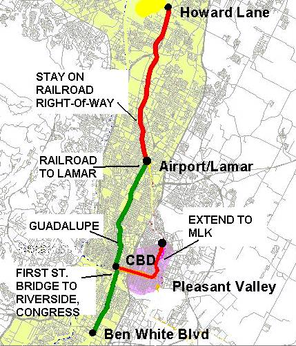
The I-35 traffic jam actually begins way north of Highland — at the confluence of Howard Lane, North Lamar, and I-35 — and that’s where people would park and ride a train if it were there. But first we have to build urban rail in the right place — up Guadalupe and North Lamar.
You have to put your transit station, with park & ride (P&R) access, near the outer end of the traffic jam. You don’t have to be a transportation savant to figure this out.
After all, as the public transit planning profession knows very well, P&R facilities need to be provided well upstream of the heavy congestion on a highway facility. There’s very little hope of attracting travelers off the highway if they already have to travel through severe congestion to access the transit station.
Project Connect’s claim of “congestion relief” is especially implausible when you further consider that they’re expecting prospective urban rail passengers to slog their way through the I-35 congestion, then, just a few minutes from their destination, to exit the freeway, hassle with parking, wait for a train, and then take a long, slow, sinuous train ride into the Core Area — a route that includes entering Airport Blvd., navigating through mixed traffic on Red River St., then winding through San Jacinto Blvd. and other streets comprising this tortuous “Highland” route.
What about the the hints from Project Connect that I-35 may be a major artery that neighborhood commuters themselves, along the proposed “Highland” rail route, supposedly use to reach the Core Area? To believe this speculation, you’d have to accept a vision of about 260 commuters per peak hour from these neighborhoods, currently driving, on average, about 6 blocks to then pack themselves onto a severely congested I-35 (#1 on TxDOT’s list of the state’s most congested roads) to then travel an average 28 blocks into the Core. And doing this when they have at least four other important but much less congested local arterials, including Guadalupe-Lamar, to use instead.
Commuters on I-35 would need to drive through miles of heavy congestion to reach Project Connect’s proposed urban rail P&R at Highland ACC — thus, little potential for “congestion relief”. In contrast, Capital Metro’s Tech Ridge P&R is located upstream of I-35 congestion. Alternative Guadalupe-Lamar urban rail plan would have North Lamar Transit Center P&R at US 183, upstream of congestion. Future urban rail extension up North Lamar to Howard Lane could provide another P&R upstream of I-35 congestion. Infographic map by ARN based on Google Maps. (Click to enlarge.)
Maybe, but this is a scenario that similarly invites powerful skepticism. And is it worth over a billion dollars for an urban rail alignment that would lure perhaps about 65 motorists off I-35 in a peak hour (assuming about 25% modal split for Project Connect’s urban rail)?
Instead, as an authentic urban rail alternative to either I-35 or MoPac into the Core Area, you have to travel through the actual heart of the central city and its core neighborhoods on an actual travel corridor where you actually travel to and get off close to your destination. And a lot more of those destinations are within walking distance of Guadalupe-Lamar. That’s why there are 23,000 bus riders daily in this corridor today.
Some transit planner a quarter century ago put it something like this at an Austin public meeting: “All transit studies show that people will climb high mountains and/or swim deep rivers to access good rail service if it’s far enough out and is easily accessible by another mode (i.e., beyond the traffic jam), providing that their final destinations are within a quarter mile of a stop.”
The MetroRail Red Line demonstrates this wisdom; after Howard Lane, for passengers riding inbound AM peak trains, it’s standing-room only. And don’t expect a seat outbound in the evening rush until Howard Lane.
However, the Red Line’s biggest fault is that while it’s quite long enough, it fails to “connect the dots”. It misses serving the heavy-traffic Guadalupe-Lamar corridor, and bypasses core central-city neighborhoods, the UT campus, the Capitol Complex, and most of downtown (while providing virtually useless service for East Austin en route).
MetroRail Red Line (red) skirts entire heart of central Austin, illustrated by “Missing Link” through Guadalupe-Lamar corridor. Urban rail would provide the crucial connections to core neighborhoods, UT West Campus, and Capitol Complex missed by MetroRail. Infographic Map by Light Rail Now.
In bypassing the heart of the city and the Core Area, the Red Line does indeed miss the big dots, but people hate US 183. Before the freeway to Lakeway and beyond, the bumper sticker read: “Pray for me, I drive 183!” Nothing has changed except that we have a much bigger road, even more traffic, more stress. longer drive times, and only a glimmer of a solution around it.
And by far the biggest part of any solution is urban rail on Guadalupe-Lamar.
Summing up: Most I-35 travelers are not going to get off the freeway at the proposed Highland station when the real traffic jam starts to form at Howard Lane. The current bus park & ride, Tech Ridge Transfer Center, for AM commuters to the Core, is located where it makes most sense — much further north (upstream) from Highland, at Howard near I-35.
Again, it comes back to the real alternative: Urban rail on Guadalupe-Lamar, which could serve a P&R station at the North Lamar Transit Center (upstream of the congestion on North Lamar) — with a clear path for further extension north — and interface with train service to the northwest (initially MetroRail, eventually an extension of electric urban rail) serving outlying P&R facilities such as Howard and Lakeline.
We think that’s a “congestion relief” plan that actually makes sense. ■
Lyndon Henry speaking to Central Corridor Advisory Group, 16 May 2014. Screenshot from City of Austin video.
♦
By Lyndon Henry
The following comments were made during Citizen Communications to Project Connect’s Central Corridor Advisory Group on 16 May 2014. At the meeting, Project Connect’s Urban Rail Lead Kyle Keahey revealed the agency’s estimates and proposals regarding operating & maintenance costs, property valuation and tax revenue increases, funding, phasing issues, and “governance” (oversight and administration) the proposed 9.5-mile, $1.4 billion line connecting East Riverside (southeast) with the old Highland Mall site (north), currently under development as a new Austin Community College campus.
For months, Project Connect and Austin civic leaders have been considering subways, elevated lines, and other extravagant investments way out of scale for an urban rail starter line in a city of Austin’s size and density. The result is a $1.4 billion plan for urban rail linking a weak corridor, East Riverside, with a non-existent corridor, so-called “Highland”.
Meanwhile, Project Connect and the city’s leadership appear to have virtually abandoned the core neighborhoods, and heaviest local travel corridor, in the central city – Guadalupe-Lamar, where urban rail is desperately needed. The problem isn’t $1.4 billion for urban rail, it’s investing this money on what amounts to a very pricey decoration instead of addressing congestion with essential mobility.
At $119 million per mile in current dollars, Project Connect’s urban rail plan for Austin would be the third most costly light rail starter line in U.S. history, in terms of cost per mile. Compared with the previous Guadalupe-Lamar light rail project, planned until 2003, Project Connect’s plan costs 29% more than what that project would cost today, yet provides 35% less route length, and 47% fewer riders.
LEFT: Capital Metro 2000 urban rail plan included initial minimum operable segment (MOS) running 14.6 miles down Capital Metro railway, Lamar, and Guadalupe to CBD, plus 5.4 miles of extension down South Congress to Ben White and branch into East Austin. Total 20.0 miles of surface route (with adaptation of existing river bridge) would cost $1.2 million in current dollars ($60 million/mile). RIGHT: Project Connect plan proposes a 9.5-mile route from East Riverside, crossing river on new “signature” bridge, proceeding through east side of CBD, East Campus, along Dean Keaton and Red River to Hancock Center, then into open cut and tunnel, then along Airport Blvd. into Highland site. Total cost: $1.1 billion ($119 million/mile) in current dollars.
Stretching over 14 miles from McNeil along what’s now the MetroRail corridor, then down Lamar and Guadalupe to the CBD, that original starter line in today’s dollars would cost roughly $878 million, or about $60 million per mile, for 54% more miles of route. Ridership for 2025 was projected at 37,400 per day – 87% higher than the “high” 20,000 for Project Connect’s plan.
The next phase involved expanding into a larger 20-mile urban rail system for roughly $320 million more in today’s dollars, also amounting to about $60 million per mile. But that’s through the heart of central and south Austin, with over twice as much rail as Project Connect’s plan. By serving Austin’s highest-traffic, most populated, densest inner-city corridors, ridership was projected at 51,000 a day.
Project Connect and Austin’s leadership seem to have abandoned all thought of cost-effectiveness and seeking the best value for spending taxpayers’ money. Now they’re playing a game of magic tricks with operating-maintenance costs and dreams of a bonanza of real estate valuation increases.
But many Austin voters realize that lower ridership means higher operating subsidies from taxpayers. And while a tax rate increase is real, projections of future tax revenues are just projections — in other words, hopes and dreams.
Judging from Project Connect’s flawed, fairytale projections from last fall’s study process, Austin voters should view these hopes and dreams with strong skepticism.
Lyndon Henry, a transportation planning consultant, is a technical consultant for the Light Rail Now Project, and a former board member and data analyst for Capital Metro. He also writes an online column for Railway Age magazine.
Map of Project Connect’s urban rail proposal, as shown by KEYE-TV. Despite blurry image quality, the convoluted, meandering character of the route, well to the east of central Austin and its core axis, can be seen. Screenshot: L. Henry.
♦
By Lyndon Henry
The following comments were made during Citizen Communications to Project Connect’s Central Corridor Advisory Group on 2 May 2014. At the meeting, Project Connect’s Urban Rail Lead Kyle Keahey revealed the agency’s proposal for a 9.5-mile, $1.4 billion line connecting East Riverside (southeast) with the old Highland Mall site (north).
I’m Lyndon Henry. I’m a transportation planning consultant, and am considered among the strongest rail transit advocates in Austin. Since I originally launched the notion of urban rail for this region over four decades ago, I’ve consistently made the case for urban rail as a crucial mobility alternative for Austin’s heaviest traffic, plus other benefits such as better urban development patterns.
Urban rail’s primary focus is mobility, to provide some relief for congestion – not to just enhance the value of real estate development or be a decoration for other public projects. Unfortunately, Austin’s political and civic leadership have lost this essential focus, and the result is Project Connect’s seriously misguided plan. Austin voters should reject it.
Austin voters are being asked to authorize a billion-dollar investment for this convoluted adornment for real estate interests and proposed developments — a line that bypasses the heart of the city and slowly meanders nine miles, from the East Riverside “Apartment City” area, through the backwater East Campus, up to Hancock, then through a tunnel and into the old Highland site. How many Austinites are traveling such a route? Installing a second rail line parallel to MetroRail along Airport Blvd. just squanders more money.
Furthermore, a vote for Project Connect’s plan is very likely a vote to lock out any hope of rail on Guadalupe-Lamar — our heaviest travel corridor — and lock in the MetroRapid bus replacement — so-called “BRT”. Project Connect has hundreds of millions of dollars’ worth of dedicated bus lanes and other infrastructure planned for this corridor that would block rail, possibly for decades.
By depleting available financial resources on tunnels and other lavishly expensive construction, this wasteful urban rail plan limits the more effective expansion of rail regionally. Tunnels and subway stations are options way out of scale for an urban rail starter line for Austin or virtually any city this size.
Voter rejection of this plan is the better option, because it opens the possibility for a return to planning a basic north-south rail spine along the central Guadalupe-Lamar corridor. Project Connect’s plan costs way too much to do too little, and Austin deserves better. Voters can opt for a better plan by saying No on November 4th.
Kyle Keahey, Project Connect’s Urban Rail Lead (bottom row, center) during presentation to CCAG. Top row, facing, left to right: CCAG leading members Bill Spelman (Austin City Council), John Langmore (Capital Metro), Mayor Lee Leffingwell, Sid Covington (Lone Star Rail). Photo: L. Henry.
At April 12th “public workshop”, attendees watch presentation from Project Connect Urban Rail Lead Kyle Keahey. Photo: L. Henry.
♦
By Lyndon Henry
On Saturday, April 12th, Project Connect held an event they described as a “Central Corridor Public Workshop” at a location on East Riverside Drive. The notice for the event stated that Project Connect team members would be available “to provide an overview of the issues under study, gather input on maps and final alternatives and answer questions. Input gathered from the workshop will help develop potential transit projects for further study.”
Prior to the event, I prepared a number of questions I would like to have answered. I also disseminated these among other Austin public transit activists.
My questions are presented below, followed by feedback — some of it troubling — that I was able to receive from Project Connect personnel.
• Why are the public (who are expected to vote ultimate approval) being allowed only these rare, occasional, highly constrained opportunities to review and select from a narrow assortment of choices determined by the Project Connect team and officials? Why aren’t the public, through an inclusive community-wide technical committee, being given the opportunity to be involved in reviewing the basic data, interacting with the consultants, and formulating the choices themselves?
One Project Connect representative seemed to recognize the value of “an inclusive community-wide technical committee” in broadening the pool of possible alternative solutions to challenging issues. He suggested that names of possible candidates for such a group could be forwarded to him.
• Why is Project Connect still going through the motions of a purported high-capacity transit “study” to determine alignment and mode, and seek CCAG and Council approval for an LPA (Locally Preferred Alternative), when it’s already submitted $1.6 billion of URBAN RAIL projects for inclusion in CAMPO’s 2040 plan — including $275mn already projected for an initial route to Hancock to open in 2020? If URBAN RAIL and its details are already a foregone conclusion, why is taxpayers’ money and the time and effort of CCAG, the City Council, and other bodies being wasted on this?
A Project Connect representative’s explanation (consistent with arguments already reported in a newspaper account) was that the “urban rail” data were submitted as “placeholders” in CAMPO’s preparatory process for its 2040 regional transportation plan. However, since Project Connect has supposedly “zeroed out” its previous urban rail plans for central Austin, and within the current “high-capacity transit” study process no mode or specific alignment has yet been formally determined, why were specific “urban rail” projects inserted as “placeholders”, and not a more generic “high-capacity transit” designation? “That’s a good question” was the response.
The dollar amounts were described as mere “updates” of previous Project Connect cost estimates from approximately 2012. But at that time, no “Hancock-Highland” route was planned, so where did the $91.4 million cost for this segment come from? This was “another good question”.
• Why is $190mn in “BRT” infrastructure being proposed for Guadalupe-Lamar? Won’t this be a barrier to future urban rail?
Including $12.9 million allocated to “BRT” infrastructure on Guadalupe and Lavaca, the total for Guadalupe-Lamar “BRT” amounts to $202.9 million. A Project Connect representative was unable to say what specific infrastructure items this included, nor whether these would present a physical barrier to future urban rail.
• Why is a Guadalupe-Lamar route omitted from the $1.6bn urban rail submission to CAMPO’s 2040 plan?
I didn’t have a chance to raise this question directly, but a Project Connect representative insisted that urban rail as well as “BRT” and possibly other modes would be evaluated for future needs in this corridor.
• Why is this plan proposing a slow, tortuous, meandering route from downtown, the least active part of the UT campus, and Hancock Center, to ultimately reach Highland/ACC? Where’s evidence of the travel demand in this route? Does this route carry as much travel as the Guadalupe-Lamar corridor?
The basic responses from a couple of Project Connect personnel at this event seemed to be that the situation has changed since the original “straight and simple” urban rail route in the Lamar-Guadalupe-South Congress corridor was proposed in 2000. Issues of comparative travel demand and ridership weren’t addressed by the personnel. However, several Project Connect representatives seemed to regret that official attitudes no longer favor shifting existing street (and bridge) space from motor vehicle traffic capacity to urban rail.
• What’s the ridership projected for this route? (Wouldn’t that be considered in the decision to submit this to CAMPO?) How can Project Connect claim that this route would have more ridership than the 30,000+ daily ridership previously forecast for the Guadalupe-Lamar route?
A Project Connect representative emphasized that ridership figures for the current proposed line will be forthcoming. But Project Connect representatives seemed to regard previous assessments of the potential of urban rail in the Guadalupe-Lamar corridor as a moot issue.
• Why is a new $75mn bridge proposed to cross Lady Bird Lake, when either the Congress or S. First St. bridge could be retrofitted for urban rail at half the cost or less ($23-36mn)?
Project Connect Urban Rail Lead Kyle Keahey indicated that the option of retrofitting one of the existing bridges was presented to the Central Corridor Advisory Group (CCAG) but was rejected by the group. Accordingly, it has not been pursued further, so the only option has been to propose constructing a totally new bridge.
I pointed out that current officials and selected civic leaders in the CCAG and Transit Working Group (TWG) seem to have adopted a position that retrogresses from the general consensus of 2000 that traffic lanes in streets, arterials, and bridges should and would be reallocated from general traffic to rail transit. Thus, Austin’s leaders appear to have taken a big step backward in their mindset.
• Is a grade separation considered necessary for urban rail to cross the MetroRail line? Why? Dispatching is entirely under the control of CapMetro. Light rail already crosses heavy rail lines in Philadelphia and Tampa. (This issue would also be involved in the case of urban rail on N. Lamar and the MetroRail line.)
According to a couple of Project Connect personnel, because Capital Metro is converting MetroRail to full compliance with Federal Railroad Administration (FRA) heavy rail standards, the unfortunate (and disputable) assessment of Project Connect planners is that urban rail can no longer cross this line at grade, unlike general traffic. This has not specifically been discussed with either FRA or the Federal Transit Administration (FTA), but Project Connect doesn’t want to get involved with the FRA over this. This also means that, according to Project Connect, urban rail will not cross the MetroRail line at grade either downtown or on North Lamar.
I pointed out that this now encumbers any urban rail plan with an extra liability of tens of millions of dollars for constructing grade separations at any future crossing, but Project Connect and civic leaders now seem to exhibit an unfortunate willingness to accept this. The “Highland” urban rail route plan now includes options for tunnels with a cost range of $230 to $290 million for urban rail to access the north side of the MetroRail line and reach Airport Blvd. This would seem to push the total cost of just the downtown-Hancock-Highland/ACC segment close to $600 million (roughly $275 million + $90 million + $250 million).
As I pointed out to several Project Connect representatives, this entire “study” process (post-2004 through the creation of the Project Connect consortium) has resulted in morphing from a simple, relatively straight, affordable surface urban rail route through central Austin’s major activity centers and highest residential densities, with no need for any major civil works, into a meandering, convoluted, complicated route serving more marginal activity centers and less density, and requiring vast expense to build bridges and tunnels.
Urban rail (light rail transit) route proposed in 2000 was much straighter, simpler, cost-effective, and affordable, with no major civil works — and it served central Austin’s heaviest travel needs and highest population density. Project was approved by majority of City of Austin voters, but ballot measure very narrowly (<1%) failed in Capital Metro service area as a whole. Map: Light Rail Now library.
This seems to be the result of errors that are built upon previous errors — in a sense, a process whereby Project Connect is simply digging itself (and the Austin community) into a deeper and deeper hole. Perhaps they’ll begin to understand why I and so many other advocates of public transportation expansion in Austin have become so disgusted not only with Project Connect and its process, but also with the proposals that are emerging from it.
Apparently under pressure from City officials and various civic leaders, the Project Connect process unfortunately also seems to have departed from the goal of seeking a cost-effective, affordable urban rail network for metro Austin. In addition to the other revelations, this was indeed very disturbing. Ideally, the entire Project Connect process would be “reset” back to zero, and a totally new process, embracing once again this goal, would be re-launched.
Possibly, a rejection of Project Connect’s plan and quest for bond funding in November by voters would lead to such a “re-boot” of the urban rail planning process. Otherwise, if this approach to rail development goes forward, it would certainly seem that future rail transit infrastructure expansion in Austin would be severely constrained by the legacy of bad past decisions and design criteria that impose very heavy cost encumbrances.
You are currently browsing the archives for the Lyndon Henry’s postings category.
What We’re Seeking
• Development and expansion of an attractive, cost-effective multi-modal light rail and regional passenger rail transit system throughout the Austin metro area
• Improvement and expansion of Amtrak intercity rail passenger service
• Development of regional rail passenger service connecting metro Austin with other communities