Archive for February, 2014

h1

Subway cost per mile nearly 9 times higher than for light rail, says study

15 February 2014
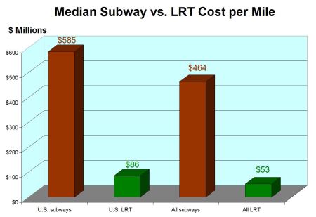
Chart showing median cost results from Light Rail Now subway vs, LRT study. Graphic: Light Rail Now blog.

Chart showing median cost results from Light Rail Now subway vs, LRT study. Graphic: Light Rail Now blog.

For years, Austin’s civic leaders and official urban rail planners have been trying to figure out how to raise more than $500 million in local and federal funding for a new-start surface urban rail project — 5-6 miles of light rail transit (LRT) running in relatively lower-cost surface alignments. Suddenly, at least some official interest has turned to ….building a subway instead?

This seems to be influenced mainly by two factors:

• An aversion or reluctance to shift urban public thoroughfare space away from apparently precious motor vehicle traffic and re-allocate it to public transit (rail in this case), and

• Insistent claims by several subway proponents (disputed by professionals and advocates of LRT) that subway construction costs are nearly the same as, or only slightly more than, surface LRT.

Recent study results of subway-LRT investment costs posted on the Light Rail Now (LRN) blog site provide a sobering reality check on the cost issue. As portrayed graphically in the chart at the top of this post, LRN found median investment cost to be nearly 9 times higher for subway construction projects than for in-street LRT.

Projects examined were an assortment of “recent urban rail projects (all from the 2000s), either completed or well under construction and fully budgeted.” The report lists 24 subway and 13 LRT projects included in the analysis.

• Only “full subway projects (entirely or nearly totally underground)” were examined in the study, including subway portions of LRT projects.

• Only surface LRT projects exclusively, or nearly totally, in street alignments were included (“to compare the most difficult, highest-cost type of surface construction with subway construction”).

Summarizing the study results, LRN underscores the huge cost disparity between subway and in-street LRT construction, and the implications for a long-term rail expansion policy:

…for recent U.S. projects, subway construction has a median cost nearly seven times that of in-street LRT construction. Worldwide, the differential is nearly 9:1. And thats only comparing in-street LRT construction, not accounting for the possibility of, say, transitioning into an available railway alignment outside the city center, with far lower installation cost.

What this means is that, even if your community can somehow afford the initial financial commitment (even with federal assistance), expansion of your system will be severely attenuated. Basically, for a given amount of available funding, you can construct 7 to 9 times as much surface LRT as subway. Put another way: For available resources, you can have a far more comprehensive rail system with surface LRT, many times the size of a system relying on subway construction.

Buffalo's 6.4-mile LRT line, with 5.2 miles (81%) in subway, has never been expanded since its opening in 1985. On the whole, the heavy cost of subway (and elevated) construction has been a powerful deterrent that has delayed or prevented the expansion of totally grade-separated urban rail systems.

Buffalo’s 6.4-mile LRT line, with 5.2 miles (81%) in subway, has never been expanded since its opening in 1985. On the whole, the heavy cost of subway (and elevated) construction has been a powerful deterrent that has delayed or prevented the expansion of totally grade-separated urban rail systems. Photo: Buffalo Tourism.

(LRN’s results — which tabulate subway construction costs ranging from $114 million to well over $1 billion per mile — appear generally consistent with information provided at Project Connect’s Feb. 8th “interactive workshop”. Official consultants at this event described “tunnel” construction as costing in the range of $220 to $350 million per mile. However, it’s unclear whether this included the costs of underground stations, access portals and ramps, and major system costs such as rolling stock and storage-maintenance-operations facilities.)

Noting examples of appropriate subway deployment in Dallas and Portland, LRN emphasizes that, for these mature systems, some underground construction may be needed “to keep pace with ridership growth and the need for fast, more frequent service going beyond in-street capacity.” However, the article points out that “both cities relied primarily on surface construction to start and develop their initial systems….”

LRN’s report ends by cautioning that, in the face of evidence from this study, any commitment to launch a new urban rail startup system “should not be made on the supposition that a subway would cost ‘just a little bit more’ than constructing LRT in the street.”

h1

Science seems missing from Project Connect’s “scientific” transit planning

10 February 2014
Project Connect's proposed "high-capacity transit" alternative alignments for "Highland" sector.

Project Connect’s proposed “high-capacity transit” alternative alignments for “Highland” sector.

By Lyndon Henry

This past Saturday, Feb, 8th, I attended Project Connect’s “interactive workshop” event at the Highland ACC site with a specific mission in mind: raising questions to gather information and data. I particularly wanted to refrain from actually providing input into the process, because Project Connect seems to use this type of public feedback as evidence of popular validation of, and acquiescence to, their overall process, methods, and conclusions — and I wanted to avoid that as much as possible. I did strongly encourage other supporters of the Guadalupe-Lamar alignment proposed for urban rail to attend this event if at all possible.

The most recent documents on the topic of the event, as far as I knew, were the “alternative route” maps that Project Connect had made available online, as a PDF:

http://www.projectconnect.com/connect/sites/default/files/Preliminary%20Alternatives.pdf

Through Project Connect’s presentations to the Transit Working Group and Central Corridor Advisory Group, and in other presentations and statements here and there, a multitude of questions had already been raised, and these maps raised even more issues. Much of my curiosity was motivated by unanswered questions associated with the “Phase 1” study process — supposedly a thoroughly “data-driven” study. Indeed, City Councilman (and Capital Metro chairman) Mike Martinez has emphasized that the route profiles selected by the Project Connect team are all based on a highly “scientific” process. So, in my view, it’s entirely valid to seek the “scientific” evidence that supposedly underpins the route alignment choices now being presented for public perusal.

At the Feb. 8th event, I didn’t have an opportunity to raise all my questions or obtain definitive answers to the ones I did raise, but I’m sharing much of what I did learn in this post. I’ll note that I mainly discussed these with a couple of volunteer Project Connect table moderators, and a couple of Project Connect consultants. I’ve categorized these questions into several sub-issues.

“Highland” issues

• The “Phase 1” study projected huge increases in population and economic activity in this sector by 2030. Where, exactly, would these increases occur?

Basically, the Project Connect representatives I discussed this with didn’t have an answer. They’re planning “high-capacity transit” routes on the basis of projections of enormous population and economic growth, but they seemed somewhat confused about whether there was any data indicating exactly where in this sector such growth would occur.

So, how could station locations be determined if you don’t know where the heaviest growth will be? Is there huge growth projected west of Red River, along the proposed Duval alignment? They couldn’t say.

• Do the proposed alignment alternatives take the actual locations of population and economic concentration into account? If so, how?

Basically, no — for the same reason as with the previous response.

However, I did overhear one of the consultants explain to another participant (who favored an alignment to the Mueller development area) that Project Connect was giving “major consideration” to the possibility that an alignment serving Hancock Center would “set you up” for an ultimate extension to Mueller.

• Of the routes within the “Highland” sector from the UT campus to Highland/ACC, I-35 is omitted. Yet heavy traffic on I-35 was included as a major factor in swaying the Phase 1 recommendation for this sector. So, why is this major travel artery not included as a possible “high-capacity transit” (HCT) alignment for this sector? Where’s the metrics-based evaluation to eliminate it?

The impression I got from discussing this is that there’s no “metrics-based” evaluation, just a sort of hunch that an alignment in or along I-35 would not be a good idea. So, if traffic volumes on I-35 were a major factor in selecting the “Highland” route, are there any park & ride sites in mind? I was told that the Highland/ACC site would be an excellent location for a P&R facility — and that seems a quite reasonable judgement.

However, there’s been no study of the relative attractiveness of such a P&R to I-35 motorists between access to the UT and core area via the eastern “Highland” routes or the more direct, western route via Lamar and Guadalupe.

• Duval and Red River are both capacity-constricted minor thoroughfares narrowing into 2-lane neighborhood streets. Are these routes appropriate for the mainline of a HCT service, particularly an urban rail alignment?

Project Connect is seriously considering rail on these streets, but other than that confirmation, I couldn’t get any evaluatory comments. One participant mentioned a possible streetcar-type alignment, and another argued that these were “three-lane” streets, which is hard to believe from the visual evidence. (To procure a third lane, you’d have to eliminate neighborhood street parking on Red River and bike lanes on Duval.)

Both Red River (left) and Duval (right) are narrow 2-lane neighborhood streets, with barely space for local parking on Red River and bike lanes on Duval. L. Henry screenshot from Google Maps streetview.

Both Red River (left) and Duval (right) are narrow 2-lane neighborhood streets, with barely space for local parking on Red River and bike lanes on Duval. L. Henry screenshot from Google Maps streetview.

I mentioned that “HCT” by Project Connect’s definition could mean MetroRapid bus service, but I was assured that, for reasons not explained, they have rail in mind for this route.

• To install HCT in these alignments, are property acquisitions for right-of-way (ROW) being considered?

I couldn’t get a clear answer on this.

• For these alignments, are elevated or subway alignments under consideration for urban rail? In the case of a subway, where would the portal be located (this generally takes most of a city block)?

Elevated and subway construction seems to be under consideration only in a very general way; I got the definite impression that Project Connect’s thinking is focused more on a surface alignment. I didn’t have a chance to raise the portal issue.

• Where would a storage-maintenance-operations site for rolling stock be located?

I didn’t have a chance to raise this issue. (Previous urban rail planning tended to locate an SMO facility on the Mueller site, or just north of it.)

• For the alignments along Airport Blvd., wouldn’t these duplicate MetroRail service?

A consultant explained that Project Connect doesn’t see duplication, because the HCT service (whatever it is) would have intermediate stops, unlike MetroRail. Apparently, in their minds, you only have duplication if you duplicate all or most of the parallel line’s stations. I found it rather peculiar that Project Connect planners would regard it as impermissible to replace MetroRapid bus service on Guadalupe-Lamar with urban rail, but quite acceptable to in effect duplicate rail transit service along Airport Blvd. with, possibly, another form of rail transit.

• Is Project Connect planning to replace a segment of MetroRail service with urban rail? If so, how would MetroRail connect from downtown to Crestview?

Apparently they’re not planning to replace MetroRail with urban rail in this phase of planning.

• If Project Connect is planning on FTA funding for urban rail, would this be possible with a line paralleling existing MetroRail service?

As discussed above, Project Connect doesn’t consider such a route along Airport Blvd. as duplicate service to MetroRail. I doubt, however, that — in the case of a major rail investment — the Federal Transit Administration (FTA) would readily agree with this, especially after their recent award of a TIGER grant to upgrade the MetroRail line.

Core area issues

• Various routes are proposed through the core area. On what specific core area metrics analyses are these based?

Project Connect representatives were somewhat confused by this question about core area metrics. Having followed the “Phase 1” HCT study process closely, I never saw evidence of any metrics-focused study of the core area (Core “sub-corridor”, i.e., sector). One consultant offered the University of Texas’s campus plan as a factor in the decision to follow the East Campus alignment along San Jacinto, but I explained that a plan is more like a wishlist, not a metrics-based analysis. I was told that maybe there was some kind of comparison of ridership, cost, etc. between the eastside and westside (Drag/West Campus) alignments, but nobody could produce one.

• Was a data-driven analysis of various alignments, evaluating ridership potential, cost, etc., ever performed for alternative routes through the core area?

Apparently there has been no metrics-based analysis that would guide alignments within the core area. Project Connect basically is taking major activity centers, such as the planned medical school, into account — but this is more based on whim rather than a “scientific” analysis evaluating data-based metrics.

• Was any kind of data-driven analysis of projected demographics, economic activity, etc., ever performed on the core area in the “Phase 1” study?

No, per the answer to the previous question.

• On what “scientific” data metrics-based rationale is the Drag excluded as an alignment through the core area?

Apparently none.

• On what data-driven basis is the crosstown alignment on 4th and 3rd Streets included?

I didn’t have a chance to raise this issue.

“East Riverside” issues

• The “Phase 1” study projected huge increases in population and economic activity in this sector by 2030. Where, exactly, would these increases occur?

As with the responses to similar questions in regard to “Highland” there seems to be no data for this.

• Do the proposed alignment alternatives take the actual locations of population and economic concentration into account? If so, how?

Again, apparently not, as with the previous responses. It would seem that much of the placement of alternatives is based on hunch and whim rather than a “scientific” evaluation of data elements.

• Why have other major potential alignments through this sector, such as Oltorf St., Congress Ave., and S. Lakeshore Blvd., been excluded? All of these were included in the original “ERC” sector in the “Phase 1” study. Is there data-based evidence for singling out East Riverside as the sole alignment?

Again, no one could explain this.

• Project Connect has repeatedly referred to MetroRapid, with buses running in normal general road traffic, as “high-capacity transit”. Why, then, are bridge options being considered for the “East Riverside” area? Could these buses not use existing traffic bridges?

Bridges are being considered for urban rail or possibly special bus-only use. But representatives agreed that, if MetroRapid is HCT, you could have Project Connect’s definition of “rapid transit” fulfilled by running MetroRapid buses in mixed traffic over existing bridges.
h1

Project Connect’s “interactive workshop” event was tiny gesture toward democratic engagement

9 February 2014
Structured around issue-oriented tables, Project Connect's Feb. 8th "interactive workshop" finally managed to get dozens of community participants engaged in lively discussion.

Structured around issue-oriented tables, Project Connect’s Feb. 8th “interactive workshop” finally managed to get dozens of community participants engaged in lively discussion.

Project Connect’s Feb. 8th “interactive open house-workshop” event was interesting both in the information to be learned (discussed in another posting) and in the way it was structured — at last, an opportunity in an event, open and publicized to the public, for community participants to actually raise questions and discuss issues in a small-group community environment.

In that sense, it can be regarded as at least a minuscule gesture toward actually democratic community engagement. One can only imagine how the outcome might have been different — in terms of the process of selecting routes — if even this very minimal kind of “interactive workshop” event, rather than the art-gallery-style “open houses” and highly managed shut-up-and-click-on-the-choices-we give-you “clicker workshops”, had been deployed in the “Phase 1” process of this “high-capacity transit study” process.

With at least dozens of people in attendance, the event was structured mainly around small-group tables discussing various issues, such as mode and alignment, for the proposed “high-capacity transit” services along routes selected in “Phase 1”. At these tables, questions could, at last, be asked in a group setting. This facilitated a more earnest discussion of issues, and allowed community members to interact more effectively with one another — learning things, encountering different viewpoints, exchanging new perspectives and information.

This, however, is a very long way from what’s needed for a fully democratic process with effective community oversight (along the lines of the precedence of years ago). Instead of seeking validation and acquiesence from poorly informed and misled participants, an authentic community involvement process would have one or more ongoing, widely accessible oversight committees, meeting with Project Connect staff and receiving reports — somewhat like the so-called CCAG (“Central Corridor Advisory Group”) or TWG (“Transit Working Group”), but with some members well-seasoned in the issues and armed with expertise to enable them to ask the really crucial and trenchant questions, and raise far more critical issues.

General community meetings would dispense with Project Connect’s “lecture-and-clicker” approach, and allow short presentations by staff followed by open public questions and comments at an open mike. These would be supplemented by true workshops and charettes (for which the Feb. 8th event gave a small taste of how this could work).

But don’t hold your breath — Project Connect’s leadership all along has seemed to have a firm idea of what it wants this process to propose, and doesn’t appear to be prepared to allow community input to divert it from its course.

h1

Viewpoint: Community action must clean up public agencies’ transportation planning mess

1 February 2014
Traffic congestion on North Lamar on morning of Jan. 27th, first day of full MetroRapid service. MetroRapid "rapid transit" bus can be seen in far distance at rear of traffic queue. Photo: Steve Knapp.

Traffic congestion on North Lamar on morning of Jan. 27th, first day of full MetroRapid service. MetroRapid “rapid transit” bus can be seen in far distance at rear of traffic queue. Photo: Steve Knapp.

By Mary Rudig

Mary Rudig is a Gracy Woods Neighborhood Association coach and editor of the North Austin Community Newsletter.

While I honestly don’t think it’s intentional, what I see in the recent developments with Project Connect is that Capital Metro and our transportation “experts” are continuing the same pattern government entities have always followed. Somebody at the top gets fixated on an idea, and that becomes the top-down policy for everything to do with transportation. Any thinking outside of the box is strongly discouraged.

When I moved to Austin in 1992, there was a fixation on downtown and all policy was designed to support this. Every bus route had to go downtown, and cross-connections, going around downtown to better connect destinations, and supporting the jobs/growth in the outer ring, were discouraged. This was followed by a series of other fixations — there was a change at the top, and Capital Metro became fixated on rail, going from one plan to another plan. Then came the fixation with the park-and-rides, and the Domain, and moving people from one activity node to another activity node (remember those days?). Then the fixation switched back to moving people to downtown. Again.

Now we have Project Connect, and the latest fixation is with bus rapid transit (BRT) and New Urbanism. New Urbanism will magically create a boom of jobs and housing east of I-35 very, very soon. BRT is the magic pixie dust that City Council has been looking for to fix all our woes. And all this is great — until 2015 when the new City Council takes over and another idea is put forward to be the new magic pill.

The problems though, are the same.

North Lamar/Guadalupe, the backbone of our city, is congested and constrained.

• The outer ring of neighborhoods don’t want to go to downtown, they want to go to their jobs and make cross-connections.

• The other cities in Central Texas need to get people into Austin, in a cost-effective way that won’t put a too high burden on them, because they are struggling to balance their growth needs with a tax base that just isn’t big enough yet.

• Large employers are not being held responsible for assisting with transportation solutions, such as providing shuttles and park and ride space, scheduling shifts away from peak times, flexing workers to work from home/remote offices, etc.

• The high-tech/IT jobs at the north end need more mixed transportation, and most of that transportation need is east-west.

• Many service workers are living either east of I-35 or moving to outlying communities because of the lack of affordable housing, and these populations need better transportation to get to their jobs, which again, are usually not downtown.

• We have huge gaps in how we are serving student populations outside of UT. We have absolutely no idea what the students at our vocational and smaller colleges need in the way of transportation because nobody has asked. ACC’s idea — to rotate campus populations in and out of Highland, so they can close and remodel other campuses — is both brilliant, and a transportation nightmare waiting for a place to happen.

• We are a city of small businesses, but we have barely cracked the shell with what this population needs. 80% of the city works for small business. Think about that — we don’t honestly know where 80% of our workers want to go, transportation-wise. The only study I know of that touches on this issue is the 2012 transportation study by Austin Chamber of Commerce.

• We must connect the urban core in North Austin to the urban core downtown, while figuring out a better way to shuttle people in and out of both of these cores.

Major North Austin neighborhoods. Map: LoveNorthAustin.com.

Major North Austin neighborhoods. Map: LoveNorthAustin.com.

I think Scott Morris (Central Austin Community Development Corporation) and Lyndon Henry (Light Rail Now Project) have made a good start — pick the spine, explore if we can fix it with rail or not, and then maybe we can use the coalition we have built to begin to address these other issues.

Capital Metro and CAMPO and the rest are never going to get their act together, people, because they are too busy worrying about the latest directive from the top. So it’s up to us to fix the mess they have made.

h1

Contradicting local official claims, FTA says it “would consider request” for urban rail on North Lamar

1 February 2014
MetroRapid bus (left) and simulation of urban rail (right). Actual FTA view expresses openness to consider replacing MetroRapid service with urban rail in North Lamar corridor. Photo: L. Henry; simulation: COA.

MetroRapid bus (left) and simulation of urban rail (right). Actual FTA view expresses openness to consider replacing MetroRapid service with urban rail in North Lamar corridor. Photo: L. Henry; simulation: COA.

On December 12th, in the course of a contentious meeting, the Austin City Council endorsed Project Connect’s recommendation to pursue “high-capacity transit” in East Riverside and a narrow swath of area mostly northeast of the UT campus, dubbed the “Highland sub-corridor”. (See City Council to Central Austin: Drop Dead.) Present at this meeting was a long queue of critics of the proposal, and proponents of an alternative urban rail route in the “backbone” West Campus-Guadalupe-Lavaca corridor.

Over previous months, Project Connect and its partisans had repeatedly insisted that Capital Metro’s new MetroRapid bus service in the Guadalupe-Lamar corridor – because it was funded by the Federal Transit Administration (FTA) – was an impenetrable barrier to urban rail. In recent days, the argument had intensified, with solemn declarations that even raising the issue of replacing MetroRapid bus with urban rail might so incense FTA that all future federal funding could be jeopardized.

Thus, in this context, earlier in the December 12th Council meeting, anticipating a barrage of criticism over the rejection of the Guadalupe-Lamar corridor, Councilman Mike Martinez (also chairman of Capital Metro) took the opportunity to make a special announcement, evidently intended to steal a march on Guadalupe-Lamar proponents. Word from the FTA had just come in, he intoned, that the agency considered Metro Rapid an absolutely “permanent” investment, and therefore a daunting obstacle to its replacement by rail.

From the City of Austin transcript, the following are Councilman Martinez’s remarks (for readability, edited for spelling, grammar, and punctuation):

I wanted to read a response from FTA that Capital Metro received this afternoon in a meeting with them in Fort Worth. This is an FTA official that … his response to the question about the high-capacity transit that is already going in, the BRT in the Lamar corridor.

His response was: BRT in the North Lamar corridor is a priority transit project. The project was supported by the region through CAMPO. Capital Metro and FTA signed a contract to this effect. FTA sees their investment as permanent.

It is important to consider that there are many demands for federal funds on new starts and small starts [projects]. and FTA made a permanent investment in this [corridor]. If Capital Metro were to come back to FTA and indicate there is a change in priorities or new need in this corridor, Capital Metro, CAMPO and the community would need to go through the entire planning process again to show that urban rail is the highest priority for this corridor.

That to me is a pretty definitive statement from FTA that it would be difficult, if not impossible, to go back through the process and receive new start money in that corridor. They view the current investment as permanent.

City of Austin transcript excerpt with Councilmember Mike Martinez's Dec. 12th remarks on FTA, MetroRapid, and urban rail for North Lamar. Screenshot: L. Henry.

City of Austin transcript excerpt with Councilmember Mike Martinez’s Dec. 12th remarks on FTA, MetroRapid, and urban rail for North Lamar. Screenshot: L. Henry.

While the FTA statement, as read orally, seemed less of a definitive and absolute rejection of an urban rail alternative in the Lamar corridor than Councilman Martinez portrayed it, as it turned out, further examination or evaluation of the statement was not immediately possible because a printed copy was not made available to the public for scrutiny. Instead, it took a Public Information Request by Scott Morris of the Central Austin Community Development Corporation, and over 40 days, before the actual FTA statement was made available, in the original form provided to Councilman Martinez.

The FTA’s views, as communicated orally to Capital Metro’s representative Ken Cartwright, are summarized by Capital Metro in an internal document available by download from ARN. As this document indicates, Capital Metro raised the issue: “We have been approached about the possibility of putting an urban rail investment in the North Lamar corridor where we already have the BRT investment.”

FTA’s oral (“verbal”) response is summarized:

The Austin community decided that bus rapid transit in the North Lamar corridor was a priority and the next need. The project was supported by the region through CAMPO. Capital Metro and FTA signed a contract to this effect. FTA sees their investments as permanent. However, if the Austin community were to come back to FTA and indicate that there has been a change in priorities or a new need in this corridor, FTA would consider the request. Before making this request, Capital Metro and the community would need to go through the entire planning process again to show that urban rail is the highest priority in this corridor. It is important to consider that there are many demands on federal funds for New Starts and Small Starts projects, and FTA has already made a permanent investment in this corridor.

Of particular interest is FTA’s assurance that “FTA would consider the request” for urban rail if Capital Metro and the Austin community were able “to show that urban rail is the highest priority in this corridor.”

FTA's actual statement, summarized in CMTA memo provided to Councilmember Martinez. Screenshot from PDF by L. Henry.

FTA’s actual statement, summarized in CMTA memo provided to Councilmember Martinez. Screenshot from PDF by L. Henry.

Clearly, the FTA’s actual statement on the issue of replacing MetroRapid service with urban rail is considerably more encouraging than the interpretation verbalized by Councilmember Martinez during the highly polemical Dec. 12th City Council debate on rejecting the Guadalupe-Lamar corridor and endorsing Project Connect’s recommendation for a less centrally located route for “high-capacity transit”. This basically corroborates the position expressed by Austin Rail Now.

See:

MetroRapid bus service should be a precursor to urban rail, not an obstacle!

Why the MetroRapid bus project currently is NOT an obstacle to urban rail in Guadalupe-Lamar

Bottom line: FTA’s actual statement offers a far more propitious prospect for FTA support of urban rail in this crucial core-city corridor.