Posts Tagged ‘coa plan’

h1

Lessons of the Austin rail bond defeat

20 November 2014
Campaign sign from OurRail PAC, which advocates light rail in Guadalupe-Lamar corridor, but strongly opposed City's Highland-Riverside urban rail plan and the $600 million bond proposition to fund it.

Campaign sign from OurRail PAC, which advocates light rail in Guadalupe-Lamar corridor, but strongly opposed City’s Highland-Riverside urban rail plan and the $600 million bond proposition to fund it.

By Roger Baker

Roger Baker, a longtime Austin transportation, energy, and urban issues researcher and community activist, presented these comments to the November 10th meeting of CAMPO (the Capital Area Metropolitan Planning Organization).

1. A top lesson is that with “affordability” taking the lead in Austin politics, it is getting risky to expect property taxpayers to fund road or rail projects without a lot of grassroots community buy-in. Transportation planners apparently plan for this funding shift onto local taxpayers to continue, despite its obvious unpopularity.

2. Putting a lot of roads and rail on the same complex bond package was a mistake. While technically legal, this was confusing and helped make the issue politically divisive.

3. Expecting voters to approve using up all our enviable AAA debt bonding capacity just before a new council takes office is not only bad policy, but it is likely to be distinctly unpopular with the new council candidates.

4. One lesson of this bond election is that the Austin voting public is probably smarter than many politicians give them credit for. The billion dollars offered little traffic congestion relief to most voters, since it was heavily geared toward future growth rather than existing residents. A slogan like “With roads and rail we cannot fail” couldn’t overcome the lack of much plausible benefit for most Austin voters.

5. It is probably bad policy to let private special interest groups like RECA [Real Estate Council of Austin] dictate the terms of bond elections like this one, simply because it doesn’t look very good when word gets out.

6. It was a mistake to assume that promoting a weak rail corridor designed to serve hypothetical growth would not hurt the proposal. Anti-rail, pro-road sentiment is relatively constant. Meanwhile, Austin has a sizable and active community of smart transit activists, many of them young and actively into social media, where information, both pro and con, travels fast. We already do have a Plan B, in the form of the currently much stronger and cheaper North Lamar/Guadalupe rail corridor.

7. Putting all our eggs in one planning basket, second-guessing the voters, and assuming that the bond promoters could win an election with over a million dollars’ worth of advertising and high-profile political endorsements didn’t work. This shows money power cannot reliably overcome smart, well-organized voter power. ■

Advertisement
h1

Austin: Flawed urban rail plan defeated — Campaign for Guadalupe-Lamar light rail moves ahead

5 November 2014
Election night graphic on KXAN-TV News showed heavy loss for Highland-Riverside urban rail bonds proposition. Final tally was 57%-43%. Screenshot by L. Henry.

Election night graphic on KXAN-TV News showed heavy loss for Highland-Riverside urban rail bonds proposition. Final tally was 57%-43%. Screenshot by L. Henry.

On November 4th, Austin voters resoundingly defeated the seriously flawed Highland-Riverside urban rail plan and $600 million bond proposition by a wide 14-point margin. The final tally is 57% against vs. 43% in favor of the bond measure.

Significantly, this was the first rail transit ballot measure to be rejected by Austin voters. In 2000, a proposed 14.6-mile light rail transit (LRT) running from McNeil down the Capital Metro railway alignment to Crestview, then south on North Lamar and Guadalupe to downtown, received a narrow majority of Austin votes — but the measure failed in the broader Capital Metro service area because of rejection by many suburban voters. In 2004, Capital Metro voters, including Austin, approved the 32-mile “urban commuter rail” plan from downtown Austin to Leander, subsequently branded as the MetroRail Red Line.

So why did this proposal fail? We believe it’s because Austin’s most dedicated, most experienced — and most knowledgeable — rail advocates opposed the official Highland-Riverside urban rail plan. These included long-established pro-transit organizations like the Texas Association for Public Transportation (TAPT) and its Light Rail Now Project; the nonprofit Central Austin Community Development Corporation (CACDC); AURA (Austinites for Urban Rail Action); the Our Rail Political Action Committee; and an array of important north and central Austin neighborhood and community groups.

Our own reasons for so intrepidly opposing this plan are presented in numerous articles throughout this website; for a representative summary of several of our key criticisms, see Project Connect’s gold-plated Austin urban rail plan shows planning process way off course.

Opposition from rail advocates and otherwise pro-rail organizations and neighborhood groups throughout the community seems to have thrown preponderant voting weight against the disastrously misguided rail plan, and thus, together with the usual pro-road and anti-tax opponents, tipping the balance toward majority voter rejection. As we wrote in Let’s Go Austin — Tea-baiting from an awfully glass house,

Of course, highway proponents, anti-taxation activists, and, yes, some Tea Party sympathizers have emerged to oppose this rail bonds proposition — but wouldn’t they do so in any case? What’s surely revved them up, and encouraged them to pour exceptionally heavy resources into this fracas, is undoubtedly the leading role of rail supporters disgusted and outraged at the corruption and distortion of the rail transit planning process and de facto disenfranchisement of the wider community from involvement.

But it’s clear that Austin is basically a very pro-rail city. Widespread community sentiment for urban rail — much of it for just about any rail line, anywhere — was palpably strong. This has been an uphill struggle to convince pro-rail voters that a very bad rail plan could actually be worse than nothing. (See Project Connect’s urban rail plan is “worse than nothing”.) That’s one major reason why we believe this community can move forward quickly to a sensibly designed, cost-effective light rail plan in a strong, logical route — a Guadalupe-Lamar starter line.

Nevertheless, channeling pro-rail sentiment into a vote against this terrible project has been a challenge. And added to that was the additional challenge that our side was a relatively small David against a very powerful Goliath — a fairly solidly unified political and civic elite, heavily bankrolled, backed by influential business and real estate interests with a stake in the proposed rail route, able to muster media support, and assisted by a network of various community and professional organizations (environmental, New Urbanist, technical, real estate, and others) seemingly motivated into an almost desperate embrace of the urban rail plan. And let’s not forget the 800-lb gorilla in Goliath’s corner — the University of Texas administration, dead-set on a San Jacinto alignment to buttress their East Campus expansion program.

So, against this Goliath, how did David win this? A lot of this victory is due to the broad public perception of just how appallingly bad the Highland-Riverside rail plan was. And with a staggering $1.38 billion cost that required a staggering local bond commitment, which in turn required a hefty property tax rate increase. And all that in the context of recent homeowner property tax increases and utility rate increases. So, would voters really want to approve over a billion dollars for even a mediocre rail project, much less a terrible one?

That message was disseminated widely through the community — not by pricey media advertising (rail advocacy groups and their followers didn’t have big bucks for that, anyway), but by a vast network of activities involving social media, Email messages, excellent blog-posted information, and community meetings. But traditionally anti-transit, pro-highway groups also weighed in, with big bucks to fund effective advertising (with a message focused predominantly on the shortcomings of the particular Highland-Riverside plan) to rebuff the months-long, heavy ad and media blitz from the Project Connect/Let’s Go Austin forces backing the official proposal.

This vote also represents not only a rejection of an unacceptable rail transit proposal, but also a protest against the “backroom-dealmaking” modus operandi that has characterized official public policymaking and planning in recent years — a pattern that included shutting community members out of participation in the urban rail planning process, relegating the public to the status of lowly subjects, and treating us all like fools. Leaping immediately into a process of community inclusion and direct involvement is now essential. The community must become re-connected and involved in a meaningful way.


Minneapolis-area community meeting on proposed Southwest light rail project. Photo: Karen Boros.

Real community involvement in the planning process means real community meetings with community members having a direct say in planning and policy decisions, as in this meeting in Minneapolis area. Photo: Karen Boros.


On election night, as the defeat of the Highland-Riverside rail bonds proposition became evident, Scott Morris of the Our Rail PAC issued the following statement:

Tonight’s results are gratifying, but the work remains. With this vote, Austin has rejected a bad urban rail plan. It was the wrong route and it was formed by values that were not shared by our community. What we do share with those who supported this measure is a resolve in moving forward with true mobility solutions that make transit a ubiquitous part of life in our growing city.

01_ARN_ourrail9 Today, Austin delivered a strong statement, that transit must serve the existing population first. Transit planning should not be subordinated for the purpose of shaping future development to the exclusion of ridership, cost effectiveness and efficiency. This is a mandate that any first investment in urban rail must serve the community first. If we put service to people first, it will be built and operated in a cost efficient way. The citizens did not accept the argument that a defeat would create a long delay until the next opportunity to vote on rail. Austin is ready to get the right plan on the ballot as soon as possible, with true citizen involvement in shaping that plan.

This election is just one more step in the process. As a grassroots organization, we’re committed to work hard for a solution. Tonight is the first step in a new direction. Austin has a new plan to create and a strong case to build for rail, and we think it will succeed. We will support and work with our transit agency, Capital Metro; to develop a plan for rail that is cost effective, open, fair and transparent with strong community input. It will need the community’s full support and engagement to preserve and enhance its basic services, especially to transit dependent populations, as it adjusts to a growing city.

The people have assumed a new leadership role in determining the future of transit. With this action, they have also assumed a strong responsibility for guaranteeing its future.

Let’s take a breath and get back to work.

The Highland-Riverside plan may be dead, but the campaign for a Guadalupe-Lamar light rail starter line is firing up. Light rail in this heavily traveled, high-density central corridor can become the basic spine of a far more effective and truly extensive urban rail system in the future for the city.

There’s already a strong constituency and base of support for light rail transit (LRT) in the Guadalupe-Lamar corridor. But the majority of Austinites don’t want another 14 years of top-level dithering and wavering — they’re ready to move forward with a workable, sensible urban rail plan. And certainly — especially with a new political leadership — we do face an exciting challenge informing the entire community and explaining why rail transit is essential, why it’s a cost-effective, crucial mobility solution, and why central-city street space needs to be allocated for dedicated transit, including light rail as well as improved bus service.

We’re already rolling up our sleeves. ■


Passengers waiting to board train at Dryden/TMC station Photo: Brian Flint.

Houston’s MetroRail shows how dedicating street lanes to light rail transit can dramatically improve urban mobility. MetroRail has highest passenger ridership per route-mile of any U.S. light rail transit system. Photo: Brian Flint.


This article has been slightly revised since its original posting.

h1

The fraudulent “study” behind the misguided Highland-Riverside urban rail plan

4 November 2014
Infographic shows how Project Connect’s methodology segmented Guadalupe-Corridor into nonsensical pieces, and summarizes numerous other major problems. (Click to enlarge.)

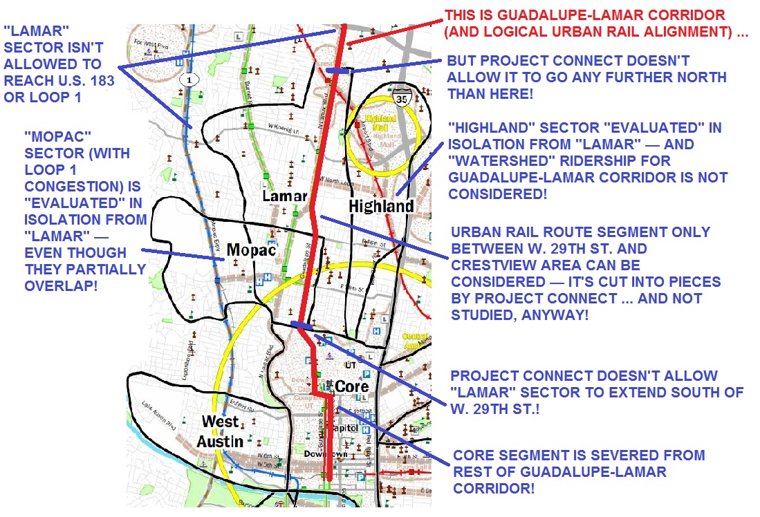
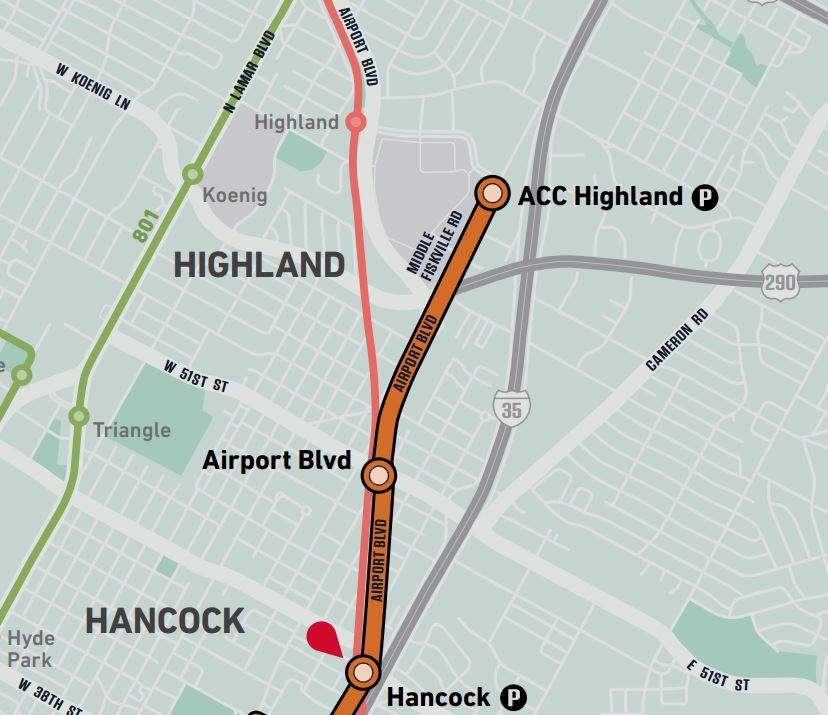
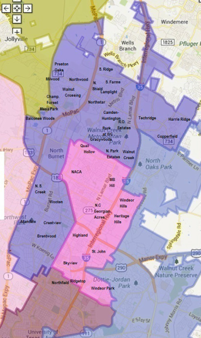
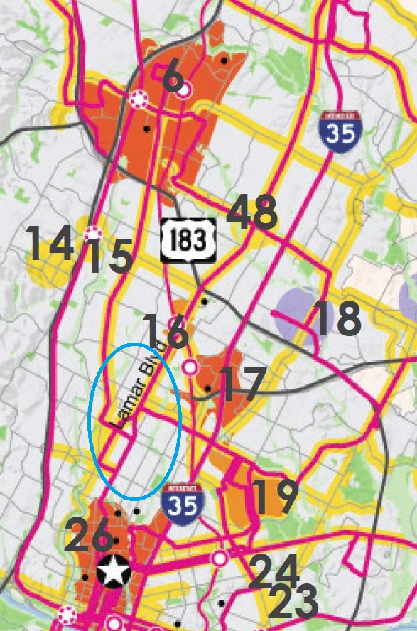
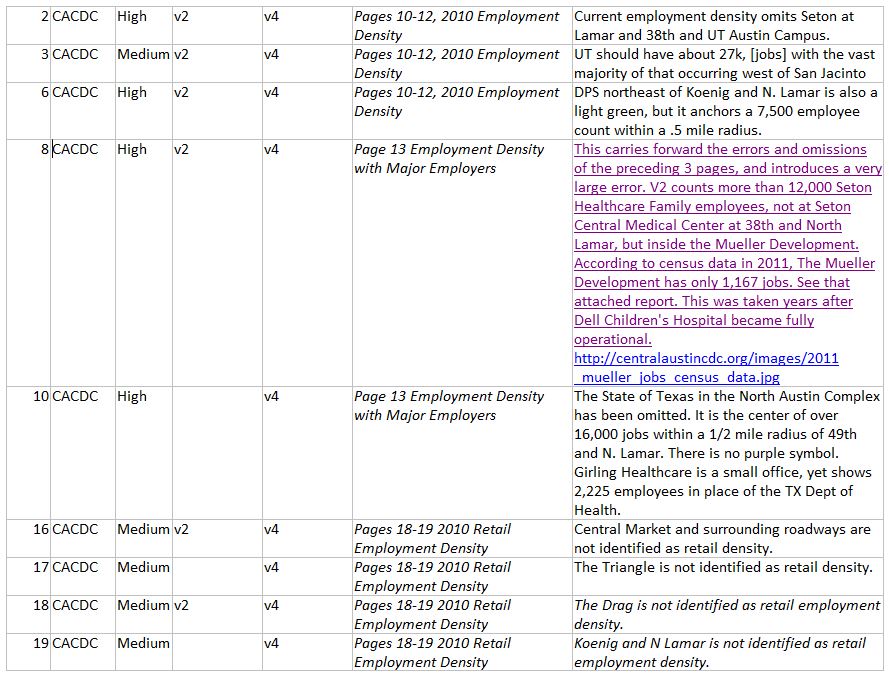
Infographic map shows several major flaws of Project Connect methodology, applied to a portion of “study” area. Result was to skew results (and urban rail route) toward desired sectors of central city. Graphic: ARN. (Click to enlarge.)

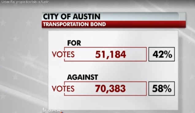
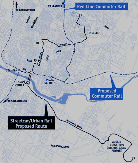
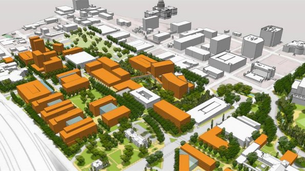
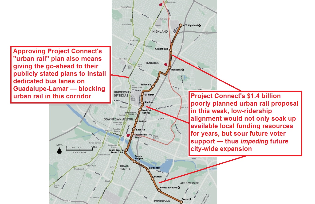
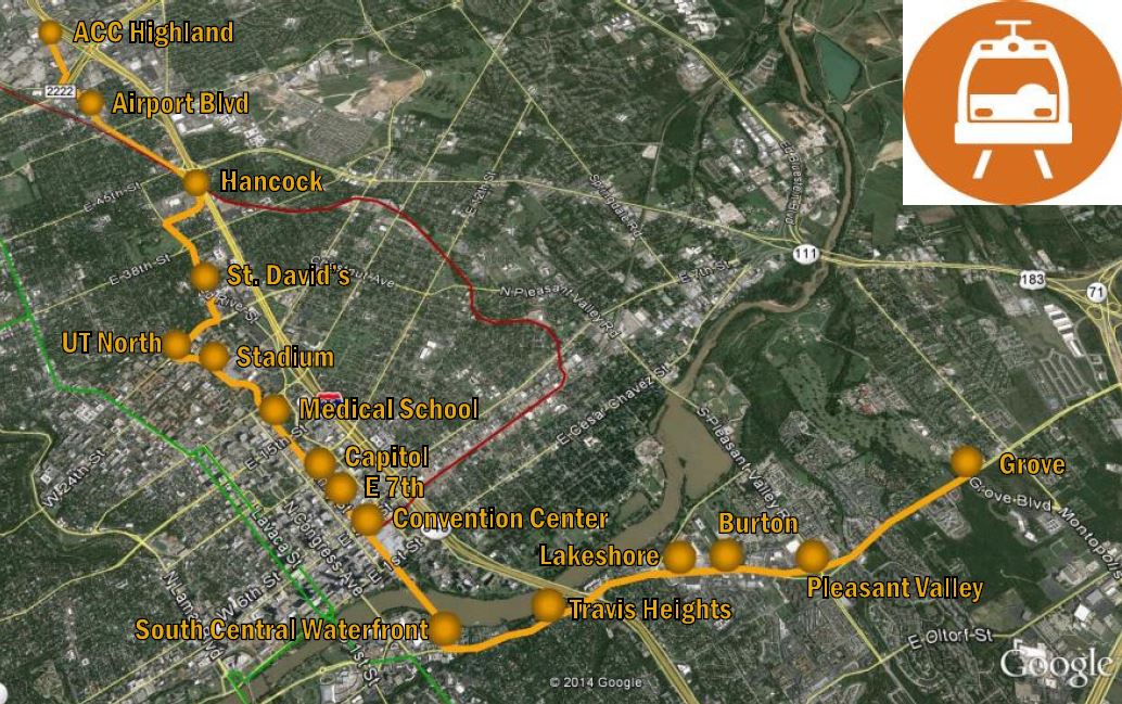
Few local issues have been more divisive than the City of Austin’s 9.5-mile, $1.4 billion urban rail plan. Envisioned for a route that meanders from the Highland ACC area on the north to the East Riverside area on the southeast, the proposal is now on the Nov. 4th ballot as a $600 million municipal General Obligation bonds measure that would help fund slightly less than half of the projected investment cost.

Community skepticism — and puzzlement — about this rail project is widespread, but sponsors and supporters of it have repeatedly endeavored to bolster its credibility by describing it as the product of a “scientific”, “data-driven”, or “data-based” effort, a “high-capacity transit study” pursued by the Project Connect transportation agency consortium roughly between June and December 2013. However, as this website and numerous other critical sources have exhaustively documented, that “study” was basically a fraud.

It’s useful to review and summarize the origins of this seriously flawed rail plan as election day has come upon us. In particular, it’s important to keep in mind that the Project Connect “study” represents an object lesson in how not to conduct a study for a New Start rail transit project. This review will rely primarily on previous articles published contemporaneously on this website during the “study” exercise.

From Mueller to Riverside to Highland

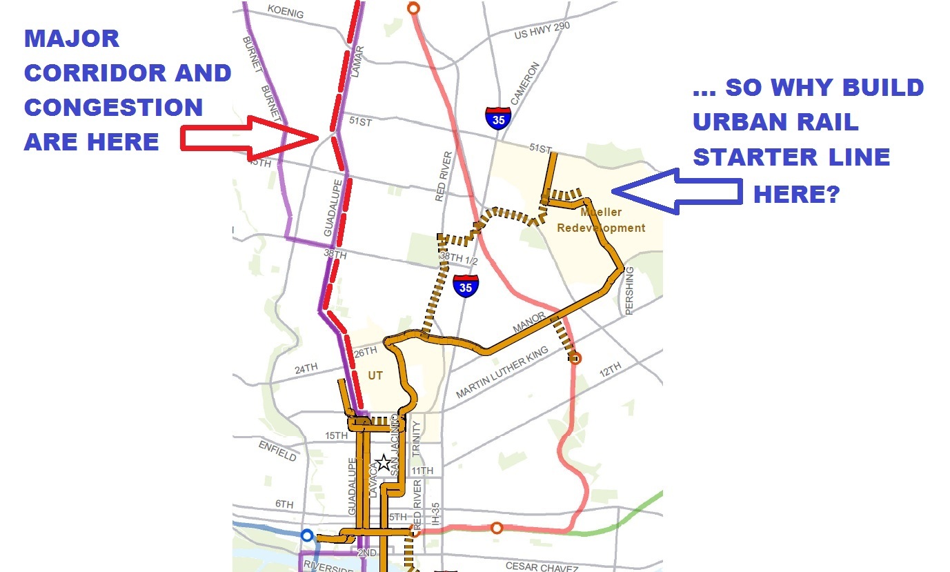
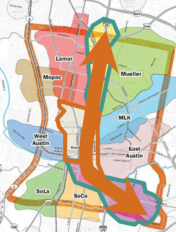
As our recent article Derailing the Mueller urban rail express — Preamble to Project Connect’s 2013 “High-Capacity Transit Study” recounted, for years, local streetcar and then “urban rail” planning had focused on a starter line to the Mueller redevelopment project. There, the major urban development enterprise Catellus had been promised a rail transit link to help raise density limits, attract more property investors and homebuyers, and thus boost profits. Important also were the desires of the small but growing community of Mueller residents who expected a rail connection to jobs and other destinations.

However, for years the question had been repeatedly raised: Since the North Lamar-Guadalupe corridor was recognized as the city’s heaviest local arterial corridor, with the heaviest congestion — even used to justify the very need for urban rail in official presentations and documents — why was out-of-the-way Mueller targeted for the initial starter line investment? This inconsistency was the focus of our March 2013 article Why abandon Austin’s major corridor and congestion problem? which presented the following graphic, originally contained in a 27 January 2012 commentary by Lyndon Henry (now a contributing editor to this website):


xxxxxxx

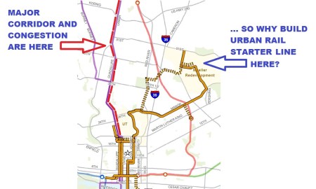
Graphic from 2012 suggested official emphasis on urban rail line to Mueller was misplaced, when real mobility need was in Guadalupe-Lamar corridor. Infographic: L. Henry.


As our “Derailing…” article, cited above, further recounts, the City of Austin/Project Connect pretext for continuing to plan an easterly, East Campus urban rail starter line to Mueller began to fall apart when the competency of a 2010 “Route Alternatives Evaluation” — the nominal basis for the plan then current — was questioned. Possibly other factors may also have begun to come into play (such as business community interest in exploring other development opportunities that could affect urban rail route planning).

In any case, the direction of rail planning shifted significantly. As our article noted,

In early 2013, Kyle Keahey was hired as Urban Rail Lead to head a new “High-Capacity Transit Study”, tasked with supposedly re-evaluating everything, racing through a process (with a presumably more competent and defensible methodology) that would result in a recommendation by the end of 2013.

Summary assessments of Project Connect “study”

Personnel associated with Austin Rail Now, the Light Rail Now Project, and other pro-rail organizations were involved intimately in following the planning activities of the “high-capacity transit” exercise from midsummer through the early winter of 2013. A number of our articles, particularly beginning in early November, chronicled revelations and realizations about the planning process as they emerged at the time.

However, a reasonable overview of the fundamental problems with the Project Connect exercise is provided in two of our articles in particular, each of them based on major commentaries by Lyndon Henry addressed to the Central Corridor Advisory Council (a group of community leaders hand-picked by Mayor Lee Leffingwell to review and approve work of the “study” team). These two articles, from early December 2013, together represent in essence an indictment of the competency and indeed the very legitimacy of the Project Connect exercise:

Memo to CCAG: “Pause” study or include “Lamar” sector

Project Connect Needs an Overhaul

What emerges is the sense of a process that was corrupted and skewed to render what, in hindsight, appears to be predetermined results — results seemingly contrived to justify a routing scheme for the proposed urban rail starter line project contrived to fulfill the aims and desires of City of Austin policy and various special interests. As our article Surprise! Mayor and Project Connect select same routes they wanted in the first place (17 November 2013) assessed the process, Project Connect’s “study” seemed to have

… numerous hallmarks of having been rigged, from a peculiarly contrived methodology that departs from longstanding professional practice, to cherry-picking of a highly questionable set of data elements and the exclusion of data indicators far more appropriate for such an ostensible “corridor study”. (And, one might add, a highly secretive and insular process that immunized the ProCon team and their study procedures from public scrutiny and oversight.)

Thus the basic flaw in ProCon’s data analysis can be boiled down to one word: GIGO (“Garbage In, Garbage Out”). In effect, this appears to have been a process that involved limiting the focus to gerrymandered data sources, and then playing games with gerrymandered data.

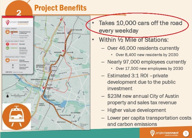
The task facing Kyle Keahey and the Project Connect team was daunting. The prevalent public sentiment strongly favored the Guadalupe-Lamar corridor for the urban rail starter line. Most Austinites sensed that Guadalupe-Lamar carried the heaviest traffic, served the highest density, and accessed the most key activity centers in the central city. Yet the City of Austin administration, Project Connect political leadership, and a major segment of local political and civic leaders desired a “study” outcome that would validate their economic and real estate development objectives. Project Connect’s effort would therefore have to try to convince the community, “Don’t believe your lying eyes.”


PowerPoint slide in Nov. 2013 Project Connect public presentation shows audience's overwhelming preference for "Lamar" — a proxy for the Guadalupe-Lamar travel corridor. Photo: Workingbird Blog.

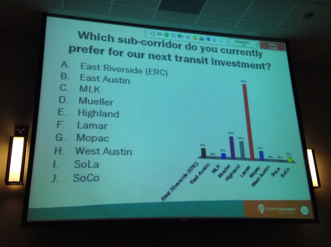
PowerPoint slide in Nov. 2013 Project Connect public presentation shows audience’s overwhelming preference for “Lamar” — a proxy for the Guadalupe-Lamar travel corridor. Photo: Workingbird Blog.


Critical failings of the Project Connect “study” charade can be grouped into categories of practices. The following summaries of these practices include references to various ARN articles that may further illuminate these issues.

► Failure to examine travel corridors

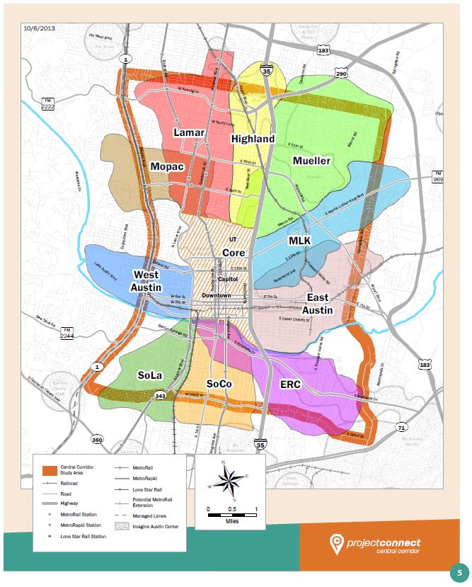
Rather than zooming in on, and analyzing, actual travel patterns and density of travel in actual travel corridors within central Austin, the “study” instead carved out a great square of the central city, dubbed it the “Central Corridor” (although it contained multiple corridors in every direction), and then further subdivided this into a series of ten component sectors, some sprawling over considerable expanses of urban real estate. Since virtually the entire central city had been designated a “corridor”, these sectors were then dubbed “sub-corridors” — a kind of camouflage verbiage that masked the actual nature of what were in effect city neighborhoods or districts, not travel corridors. The “sub-corridor” designation also imparted a veneer of “transportation study” truthiness.

Our first analysis of this methodological problem, Project Connect’s “corridor” study — without corridors! noted that Project Connect’s subdivision of the study area in this way thus

… created an array of balkanized sectors that are analyzed more as autonomous geographic-demographic “islands” than as components essential to work together as a whole. As a result, actual, realistic, workable travel corridors have been obscured by all this.

Our article included a detailed explanation, with examples, of what urban travel corridors actually are, and how they should be treated and evaluated in a bona fide transportation corridor study. But, rather than corridors, Project Connect’s sectors (“sub-corridors”), we pointed out at the time, “resemble, to some extent, rather large travel analysis zones (TAZs, also called traffic analysis zones or transportation analysis zones).”

But, rather than TAZs for legitimate analysis purposes, we pointed out,

Project Connect’s sectors, in contrast, seem more designed to pit one part of the city against another — to function more as neighborhood enclaves to be assessed for their isolated demographics and “level of misery” (poverty, congestion, etc.) in a competitive showdown within a game of “Which sector deserves the urban rail prize?” It’s astounding that this charade is presented as a form of officially sponsored urban transportation planning.

Together with the agency team’s “seemingly heedless” segmentation of travel routes, their “treatment of adjacent sectors as insular, isolated enclaves, whose demographics and other characteristics apply only to themselves” was equally harmful to proper analysis. “Likewise travel characteristics are treated in isolation, as if the population in all these different ‘enclaves’ confine themselves to the sector boundaries that ProCon planners have established for them.”

Throughout the “study” process, we repeatedly returned to this problem. Our article Questions for Project Connect (3 December 2013), publishing questions which we raised in a “data dig” with Project Connect team members, asked “Why has this study avoided performing an actual corridor study, and instead spent its time (and taxpayers’ dollars) confined to undertaking a de facto inventory (and ‘beauty contest’) of various urban sectors in isolation?”

In our Memo to CCAG: “Pause” study or include “Lamar” sector (5 December 2013) we noted that “The basic methodology of focusing on sectors (so-called ‘sub-corridors’) meant that the study failed to study a single actual potential travel corridor in the study area.”

► Gerrymandered “study” sectors

Our Project Connect’s “corridor” study — without corridors! article, pointing out the peculiar boundaries applied to Project Connect’s weirdly sprawling sectors, described them as “gerrymandered”, and further experience confirmed this assessment. Our 17 November 2013 article Surprise! Mayor and Project Connect select same routes they wanted in the first place observed that

rather than performing a bona fide study of actual alternative corridors, ProCon embarked on what amounted to an inventory of highly filtered attributes of basically gerrymandered sectors, dubbed “sub-corridors”, devolving into a kind of “beauty contest” among sectors of the city, while distorting as well as ignoring the actual travel corridors that should have been the focus.

The article provides the example of the highly contrived “Highland” sector:

It should be noted that the “Highland” sector bears very little resemblance to the actual Highland neighborhood, delineated by both the Highland Neighborhood Association (see Highland Neighborhood Association endorses Guadalupe-Lamar for urban rail) and the Highland Neighborhood Planning Area defined by the City of Austin (COA). While the actual Highland neighborhood and planning district includes North Lamar Blvd. (mostly as its western boundary) all the way from Denson Drive to U.S. 183, ProCon’s “Highland” sector studiously avoids Lamar, and never reaches U.S. 183; instead, the sector incorporates I-35 (never even touched by the real Highland), and droops down far south of the actual neighborhood to include Hancock Center and the northern edge of the UT campus — thus overlapping the long-proposed Mueller route for urban rail. In this sense, “Highland” appears to be manipulated here as a kind of “proxy” for the COA’s original plan, functioning as a precursor of a full route to Mueller.

► Severed and segmented travel corridors

This was perhaps the single most serious fault of the Project Connect exercise — not only failing to examine actual corridor travel patterns, but essentially destroying intact corridors, such as Guadalupe-Lamar, simply because they crossed boundaries of the arbitrary sectors. As we first noted in Project Connect’s “corridor” study — without corridors!

Perhaps the most serious flaw in ProCon’s urban rail study methodology — actually, catastrophic, because it fundamentally impairs the integrity of the whole process — is that the actual travel corridors are not only basically ignored as workable corridors, but also are truncated and segmented by ProCon’s arbitrary slicing up of the urban area.

If you’re evaluating a travel corridor, you must evaluate the corridor as a whole — what it connects from, to, and in between; what the populations and densities along the corridor are; what activity centers it connects; and so on. All those are important, because they’re critical to what makes a transit line in that corridor actually feasible and worth investing in.

The results for the Guadalupe-Lamar travel corridor were basically fatal, as we pointed out:

the Guadalupe-Lamar route is severed just north of the UT-West Campus area at W. 29th St. In other words, most of this potential route is cut off from its highest-density population district as well as its most productive destinations in the core of the city!

What’s left is a “rump” route, from a few blocks south of U.S. 183 to W. 29th St., that seems to have little purpose beyond perhaps some kind of “shuttle” along this isolated route segment. If there were a prize for idiotic public transport planning, surely Project Connect would be very high on the candidate list.

This problem also was repeatedly underscored. In our article Memo to CCAG: “Pause” study or include “Lamar” sector (5 December 2013) we warned that “The basic methodology of focusing on sectors (so-called ‘sub-corridors’) meant that the study failed to study a single actual potential travel corridor in the study area”, and added:

This methodology also segmented an otherwise viable corridor such as Guadalupe-Lamar into nonsensical pieces, severing the corridor from its most logical destination (West Campus and core area), and thus creating an arbitrary “rump” route (29th St. to south of U.S. 183) that goes from nowhere to nowhere.

Likewise, in Project Connect Needs an Overhaul (7 December 2013), we reiterated: “Project Connect’s methodology segmented the outstanding Guadalupe-Lamar corridor into nonsensical pieces, severing it from its most logical destination (the West Campus and core area), thus creating an arbitrary ‘rump’ route that goes from nowhere to nowhere.” These warnings, of course, were ignored.

► Excluding student and other nonwork travel patterns

While specific travel corridor trips were not examined in the “study”, Project Connect did include tabulations of total travel in each sector and estimates of trips between sectors and the Core Area. However, a particularly breathtaking aspect of the project’s Evaluation Matrix (also called the Comparison Matrix) was the exclusion of all trips except home-based work trips. In other words, non-work trips — including student trips — were omitted from consideration.

As we asked in our “data dig” Questions for Project Connect, “Why has this study’s assessment of “travel demand” from each sector to the core ignored home-based non-work (HBNW) trips — including UT student trips and recreational trips — in a college city with the largest university in Texas in its core area?”

This omission was repeatedly emphasized in subsequent articles. In our Memo to CCAG: “Pause” study or include “Lamar” sector, we pointed out:

As a measure of “Travel Demand” from each sector to the core, non-work trips such as UT student trips and recreational trips (e.g., to restaurants, bars, etc.) have been EXCLUDED — dismissing not only the enormous importance of non-work trips (which are heavy in the off-peak) for more cost-effective transit service, but especially the huge significance of student and recreational trips in a city with the largest university in the state (and located in its core).


Student travel was omitted from Project Connect's evaluation process, although their ultimately recommended route connected UT, the state's largest university, with ACC, the city's major community college. Photo via UTRugby.com.

Student travel was omitted from Project Connect’s evaluation process, although their ultimately recommended route connected UT, the state’s largest university, with ACC, the city’s major community college. Photo via UTRugby.com.


And similarly, in Project Connect Needs an Overhaul, we asked:

Extremely important non-work trips such as UT student trips and recreational trips have been EXCLUDED as a measure of “Travel Demand” from each sector to the core. How could they do this in a city whose core contains the largest university in the state?

In hindsight, the omission of student travel from the Evaluation Matrix is especially ironic in light of the fact that travel between UT and ACC would ultimately be a major component of the purported ridership of the final route presented by Project Connect.

► Manipulation of implausible projections

Skepticism about Project Connect’s heavy reliance on dubious projections began to emerge as the pace quickened toward a “recommendation” from the project team. In our 3 December 2013 article related to the “data dig”, Questions for Project Connect, we asked: “Why has this study used such speculative projections based on procedures that maximize all possible development for targeted areas (such as ‘ERC’, ‘Mueller’, and ‘Highland’), rather than using conservative projections based on conditions closer to reality?”

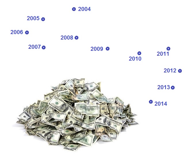
Local researchers and analysts such as software developer and research analyst Dan Keshet and management consultant Julio Gonzalez Altamirano had exposed serious weaknesses in the array of data projections being deployed by the project team — especially the conversion of what were in effect development “wish lists” into hard projections of future development, population, and employment that were being plugged into Project Connect’s model (an Excel-based “Evaluation Matrix” designed to competitively score the various sectors and render a winner). Their conclusions and other problems of the project’s data projections are discussed in our article What’s with Project Connect’s “2.9 million daily ridership” projection? (16 December 2013). As this article noted,

The question of projections has been an extremely contentious issue in Project Connect’s urban rail “study”. For many critics, the agency’s “projections” have represented de facto fantasies about what they would like to see, rather than the solidly reliable output of competent predictive analytics.

While projections were critical in any process of forecasting future developments and especially public transit ridership, we explained, “…there’s a vast distinction between developing conservative, reliable, and plausible forecasts, and producing exaggerated, fantasy-like projections, as Project Connect has done, heavily skewed toward certain geographical areas.”


Many of Project Connect's "data projections" for 2030 were based on "wish lists" of development, population, employment, and other demographic features — leading critics to ridicule them as "fantasy". Graphic via ARN.

Many of Project Connect’s “data projections” for 2030 were based on “wish lists” of development, population, employment, and other demographic features — leading critics to ridicule them as “fantasy”. Graphic via ARN.


In the 17 November 2013 article Surprise! Mayor and Project Connect select same routes they wanted in the first place, we expressed skepticism about “the selection of a predominantly questionable array of data elements as the basis for ‘evaluation’ of the various sectors. Leaving their ‘weighting’ aside, in the aggregate the evaluatory elements themselves are inappropriate.”

As the article explained,

ProCon relies very heavily on projections of future conditions for their basic measures. As the rail advocacy group AURA (Austinites for Urban Rail Action) has explained in its evaluation guide, projections themselves are basically unreliable, risky, flaky, whereas, in contrast, “We believe use of the real-world, recently-observed data gives the more accurate and reliable picture of potential ridership, as well as the greatest viability for federal funding.”

… Beyond a roughly five-year horizon, projections for specific neighborhoods and similar chunks of real estate basically become unreliably speculative — which seems to be what we’ve actually been dealing with … a significant dollop of real estate speculation, given a kind of veneer of “techiness” by CAMPO and their land use/travel demand model package.

For decades, public transportation advocates have warned repeatedly about the “self-fulfilling prophecy” syndrome in this kind of transportation planning process. In the past, it’s been applied mainly to highway development — justifying “future growth” in just the right places where developers want to build, so as to rationalize huge investments in new freeways and other roads. And, lo and behold, these very projections somehow materialize after the transportation facilities are built, thus “proving” the “validity” of the projections!

Today, in Austin, this process may be at work justifying speculative land development in certain areas of the central city (i.e., the central study area — “Central Corridor”), this time with the added drawback of ignoring or dismissing opportunities for redevelopment of areas in the heart of the core city, particularly centered along the Guadalupe-Lamar corridor.

As an example, in our article “Highland” sector favored by Project Connect — but where’s the travel demand? (19 November 2013) we noted that Project Connect’s presentation of CAMPO travel demand data in their own Map Book contradicted the claims of high travel demand in the “Highland” sector — one of the key underpinnings for their “recommendation” of a route to serve this fabricated sector. Thus, we warned, “since Project Connect based its assessment significantly on this data, the results presented, and the contrary evidence of very strong travel demand in the Guadalupe-Lamar corridor, contradicting Project Connect’s own stated conclusions, should at the very least raise questions about the competency and integrity of the study process.”

As we summarized the pattern in What’s with Project Connect’s “2.9 million daily ridership” projection?

Another way of saying this is that Project Connect’s planners have converted their own wishful thinking into actual data inputs, that are then deployed to make their evaluation. Wishes are used to try to make the wishes come true.

► Applying subjectively derived scores

Despite the characterization by supporters that Project Connect’s efforts were thoroughly “data-driven” and “scientific”, some components of their “study” were not even camouflaged as “projections” or externally derived data, but instead were presented merely as subjective judgements of the project team. In our 3 December 2013 “data dig” Questions for Project Connect, we asked

Project Connect’s “Physical Constraints” metric appears to be based on totally subjective value assessments, and no information has been given as to how these value judgements have been developed. Where’s the factual basis for this?

The response was that these scores were based purely on the team’s “professional judgement”. We highlighted this on our article Memo to CCAG: “Pause” study or include “Lamar” sector:

The study has assigned an extremely high “Constrained Right-of-Way” penalty to the “Lamar” sector, but not to the “Highland”, “Mueller”, “ERC” sectors — apparently implying that Project Connect considers there to be no “Constrained Right-of-Way” problems for “Highland”, “Mueller”, and “ERC”. This also is implausible, and this penalty seems to be arbitrarily applied to sectors (“sub-corridors”) that the Project Connect team dislikes (e.g., “Lamar”), but withheld from sectors they seem to prefer (e.g., “ERC”, “Highland”, “Mueller”).

► Selective manipulation of data

Another practice skewing Project Connect’s “study” results was their “cherry-picking” of data categories and their selective manipulation of their own methodology — pre-eminently, the Transit Orientation Index model they appropriated from Portland. As we explained in our analysis What’s with Project Connect’s “2.9 million daily ridership” projection? (16 December 2013):

Apparently in an attempt at a gesture toward some kind of prediction of future transit ridership, one of the metrics Project Connect decided to use in their Comparison Matrix is a “Transit Orientation Index” (TOI), a ridership demand assessment model developed in 1997 by consultants for Portland, Oregon’s TriMet transit agency. …

According to the documentation, the TOI metric is envisioned to assess transit ridership demand at the level of a small analysis zone …. Project Connect planners, however, have applied the model to considerably larger sectors covering several square miles with hundreds and even thousands of acres.

We’d previously summarized the astounding problem with the TOI model in our Memo to CCAG: “Pause” study or include “Lamar” sector, which warned that, when key projections, already embedded in the Evaluation Matrix, were plugged into the TOI,

… the results are extremely implausible — e.g., for the “ERC” (East Riverside) sector, Project Connect calculates high total daily transit ridership of 2.9 million, about equal to the total citywide daily ridership of Chicago and Philadelphia combined. (Their “low estimate” for that single sector is higher than the total citywide ridership of entire cities like Denver and Seattle.) This strongly tends to corroborate other evidence that Project Connect’s projections have been seriously exaggerated and are utterly implausible.

Likewise, in Project Connect Needs an Overhaul we observed:

Rather than developing conservative, reliable, and plausible forecasts, Project Connect has produced exaggerated, highly questionable projections, heavily skewed toward certain geographical areas. When these same projections are plugged into Project Connect’s own Transit Orientation Index (TOI), the results are ridiculously unbelievable. For the single “ERC” sector, the low-end prediction of daily transit ridership is higher than the total system daily ridership of entire cities like Denver and Seattle. On the high end, it’s about equal to the total system daily ridership of Chicago and Philadelphia combined.

These implausible outputs from the TOI were jaw-dropping. When the projections of Year-2030 population, employment, and other data items that were mainstays of their Evaluation Matrix were fed into the model, even the low-end results were absurd. For the “ERC” (East Riverside) sector, for example, as we pointed out in our What’s with Project Connect’s “2.9 million daily ridership” projection? analysis, “… the low-end figure — daily ridership of 492,682 (493K) — is equally preposterous, exceeding the total system daily ridership of entire large cities.” These cities included Portland, Seattle, Denver, and Atlanta.

As for the Highland sector, TOI results were likewise other-worldly. As we noted,

…the TOI model results for 2030 are similarly off the scale. Whereas current 2013 ridership is about 5K (5100/day), the “low” TOI prediction for 2030 is about 127K — an increase of 2,440%. The “high” prediction (no need for upper-bound substitution in this case) is 279K — a predicted increase of 5,480%.

Put another way, to meet the lower-end ridership suggested by the demographic and economic projections, average daily ridership in the “Highland” sector would have to exhibit sustained average daily ridership growth of about 7,200 each year for 17 years.

Curiously, while the project team excluded such embarrassing outputs from the TOI model from their matrix, they were selectively using other aspects of the TOI as inputs for the same matrix. As we noted,

… Project Connect’s matrix does use the TOI, itself based on the same dubious projection inputs, to render a metric score to bolster their preferred sectors (“sub-corridors”) in the competition they’ve set up. …

But, even more importantly, the TOI for 2030, dependent as it is upon Project Connect’s “projections” (de facto fantasies), exposes their absurdity. No wonder Project Connect and its entourage don’t want these used … no wonder they attempt to distance themselves from them!

It’s very simple — plug Project Connect’s own projections into this otherwise fairly realistic model, and you get bizarrely, unbelievably exaggerated results. Maybe a hint that the original projections are bizarrely unbelievable?

In effect, the TOI is performing here somewhat like a “canary in the coalmine” — telling Project Connect, and all of us, that something is terribly wrong with their demographic and economic projections for 2030.

Big Picture: Fraud

The impact of all these seemingly disconnected errors, missteps, omissions, and methodological shenanigans on a single portion of the “study” area is illustrated by the infographic at the top of this post, which focuses on several of the sectors surrounding the Guadalupe-Lamar travel corridor. (The so-called “Lamar” sector was widely misinterpreted as this corridor itself, but it was actually just a wide swath of urban real estate, stretching as far west as Shoal Creek Blvd., and embracing Burnet Road to the west as well as a segment of Guadalupe-Lamar in its eastern half — and neither of these two major travel corridors was examined.) As this graphic makes clear, the ground rules and methodology of Project Connect’s “study” very effectively prevented meaningful evaluation of this key, heavily traveled, central corridor.

From this grab-bag of colossal problems, your first assessment might be that Project Connect’s team was the rail planning equivalent of The Gang That Couldn’t Shoot Straight. Unfortunately, it’s worse. What actually emerges out of all this, from the vantage point of a year of hindsight, is a much more troubling image than mere ineptitude — by connecting the dots, the outline of a deliberate effort to deceive and to manipulate the “study” becomes unmistakable.


Kyle Keahey promoting "high-capacity transit" route selected by Project Connect, Nov. 2013. Photo: YouTube screengrab.

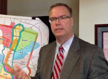
Project Connect Urban Rail Lead Kyle Keahey presenting “recommendation” of Highland-Riverside urban rail route, Nov. 2013. Photo: YouTube screengrab.


Contradictory as it might seem, it’s entirely plausible that otherwise technically competent members of the Project Connect team, drawn into the “trees” of the exercise, were unaware of the implications of the larger “forest”. Also the mind, with its ability to rationalize, justify, and alibi, can be a very mysterious apparatus.

In any case, the motives for tailoring the proposed urban rail route to the needs of development policies and interests are also very clear. These are described particularly in three of our articles:

Who are those guys? Real estate development interests and Austin’s urban rail boondoggle

UT should pay for East Campus urban rail — not Austin taxpayers

Derailing the Mueller urban rail express — Preamble to Project Connect’s 2013 “High-Capacity Transit Study”

So there’s motivation. There’s an amazing assortment of jaw-dropping methodological botch-ups. And it all fits together to promote the desires of the sponsors of the exercise.

The Big Picture we see of this whole process is dominated by a bright red fluorescent flashing sign. The sign says: Fraud. This is definitely a model of rail planning for other communities — a model to avoid at all costs. ■

h1

Why Austin is faced with a “Worse-Than-Nothing” urban rail plan

2 November 2014
Graphic via Blip.tv

Graphic via Blip.tv

By Dave Dobbs

The pro-transit group AURA (Austinites for Urban Rail Action) is owed a strong acknowledgement of thanks for posting their exposé pointing out the Republican origins of the money behind Let’s Go Austin’s campaign to try to paint all the opponents of the City’s urban rail bond proposition as captives of the Tea Party. Special thanks are due to the AURA author(s) and researcher(s) who did the homework. (Also see: Let’s Go Austin — Tea-baiting from an awfully glass house.)

One person commenting recently to a local rail discussion forum made some interesting observations about Let’s Go Austin’s tactics:

I expect they’ve taken this angle because their polling says the most popular way to portray the bond is “progressive.” … I think the best chance for defeating Prop 1 is sowing doubt among the self-identified “progressives.”

I think these comments are absolutely right about sowing doubt with progressives about the forces behind the Project Connect Riverside-Highland rail bonds. AURA’s blog post reminds us of Deep Throat’s advice to Woodward and Bernstein in All The President’s Men: “Follow the money!” and Ben Bradlee’s recent death reminds us that this advice still holds today.

Uncovering the money trail reinforces my belief that the Austin rail bonds are really about maintaining “business as usual” with as little disruption as possible. In answer to “Why” Austin has a “Worse-than-Nothing-is-Doing-Stupid-Things” rail plan, I’ve offered the following analysis.

I believe that the powers-that-be chose this approach because it is the approach that does as little as possible to disturb the status quo, while at the same time tying up Capital Metro’s assets far into the future with a faux solution that benefits some of the folks in the Real Estate Council of Austin (RECA) and Greater Austin Chamber of Commerce tent (emphasis here on “Greater”). This satisfies certain city developer insiders who see the rail line as their ticket to access and greater densities, while at the same time perpetuating the business-as-usual-sprawl-ever-outward real estate speculators who need more and more roads to realize their investments on the urban fringes.

Generally, city developers and suburban developers are natural enemies, and this is the compromise to keep order in the house. An ineffectual rail start contingent upon the new city council issuing $400 million in certificates of obligation for road improvements before the bonds can be used, is a pretty clear indication of priorities. So is the fact that the city continues to collect a quarter of Capital Metro’s one-cent sales tax that is mostly spent on roads.

This explains why Guadalupe-Lamar, where light rail would be a smashing success with 40,000 riders daily, was never considered, because a G-L rail line would totally change Capital Metro from “cash cow” to a recognized indispensable tool for bringing growth into city neighborhoods sans the traffic impacts that choke the densities necessary for a more productive tax base, while at the same time creating a demand for more train service in other parts of Austin. It would also build bus ridership because buses would be shuttles to train service for people who would not otherwise use buses. And, in turn, this would create greater public demand to spend more money on public transit, bikes, and pedestrians and less for bigger, wider roads.

Given this reality, fringe-area developers and their political surrogates who control the political process want to minimize the market availability for the alternative lifestyles that many retirees and millennials are seeking. In order to do that, Capital Metro must remain an impotent dog at the heals of Austin’s road warrior masters and suburban real estate investors. (That”s polite talk for “land speculators”.) ■

h1

Derailing the Mueller urban rail express — Preamble to Project Connect’s 2013 “High-Capacity Transit Study”

2 November 2014
Urban rail concept started as a plan for a streetcar "circulator" system, shown in this early map from 2006. Map adapted from Austin Chronicle.

Urban rail concept started as a plan for a streetcar “circulator” system, shown in this early map from 2006. Map adapted from Austin Chronicle.

To understand the roots of the Highland-Riverside urban rail plan on the ballot today, you need to understand how an official “express train” planning process, aiming to lock in an urban rail line to the Mueller redevelopment site, got derailed and sidetracked by community intervention. Here’s a very abbreviated version of the story.

Austin’s current “urban rail” planning arose ca. 2005-2006 following the November 2004 voter approval of Capital Metro’s “urban commuter rail” project, in a package (including “rapid bus” service) called All Systems Go proposing the operation of DMU (diesel multiple-unit) railcars between downtown and the suburb of Leander. The previous light rail (i.e., urban rail) plan for a line on Guadalupe, North Lamar, and the railway alignment northwest as far as McNeil had been shelved in mid-2003 in favor of the cheaper, but very bare-bones, DMU plan.

Since the newly approved DMU line ran on a railway alignment that bypassed most of the heart of the city, ending only at the southeast corner of the CBD, officials and planners realized they needed some way to connect passengers with key activity points, including UT and the Capitol Complex. The answer they devised was a “circulator” system using streetcar technology, which would intersect with the DMU line (eventually rebranded as MetroRail) and connect to downtown Austin, the east side of the Capitol Complex, the East Campus of UT, and the Mueller development site. (See map at top of post.)

But, critics asked, what about the dense West Campus neighborhood and the busy commercial district on The Drag? What about the original plan for light rail along Guadalupe and Lamar? The “rapid bus” service included in the All Systems Go package, intended as a precursor to rail in the Guadalupe-Lamar corridor, was then viewed only as a temporary “fix”, and it seemed clear that rail needed to be planned for that corridor as well.

Within Capital Metro, Lyndon Henry (then a Data Analyst with the transit agency) pressed the case for at least an initial rail line to serve The Drag and West Campus, and at public meetings on the proposed “circulator” Henry and others continued to raise the issue. In this period, as problems emerged with the MetroRail project, Capital Metro’s involvement in the streetcar project was superseded by the City, which assumed control. When Henry’s supervisor Matt Curtis left Metro to become an aide to Mayor Lee Leffingwell, for a brief period a West Campus spur did appear in City of Austin planning maps for the proposed streetcar. (Henry is currently a contributing editor to this website.)

In 2008, as a line on East Riverside to ABIA, with a bridge over the river into the CBD, was proposed, planners became convinced that capacity and speed required fullsize light rail transit (LRT) rolling stock. However, apparently to distinguish the emerging plan from the original, centrally routed Guadalupe-Lamar line, and to retain some of the supposed lower-cost ambience of streetcar technology, the expanded system was dubbed “urban rail”, supposedly a hybrid between a streetcar and a rapid LRT system. By 2010, the Central Austin Transit Study (CATS), prepared by a consortium headed by URS Corporation, recommended a system that stretched from the Mueller site, down Manor Rd. and Dean Keeton to San Jacinto, then south through the East Campus, across the river, and out East Riverside to ABIA. Alternative alignments were suggested, and spurs to Seaholm and the Palmer Auditorium area were also proposed as later extensions.

As the project made its way through the National Environmental Protection Act (NEPA) process, and afterward, the route structure gradually solidified; for a connection to Mueller, a preference was emerging to move the alignment from Manor Rd. to a route via Red River and Airport Blvd. But even the gesture of a spur connection to the West Campus began to vanish, prompting Lyndon Henry and the Light Rail Now Project to call attention to the need for urban rail in the “Missing Link” — the gap between MetroRail’s station at Crestview and North Lamar, and its terminus downtown. Because of that gap, not only were passengers inconvenienced by having to transfer to buses to access their destinations along the Guadalupe-Lamar corridor, but also Capital Metro was running costly bus shuttles to connect MetroRail stations on the east side to the UT campus and the Capitol Complex. See: Give priority to “Missing Link”.


MetroRail Red Line (red) skirts entire heart of central Austin, illustrated by "Missing Link" through Guadalupe-Lamar corridor. Urban rail would provide the crucial connections to core neighborhoods, UT West Campus, and Capitol Complex missed by MetroRail. Infographic Map by Light Rail Now.

“Missing Link” urban rail (green), in Guadalupe-Lamar corridor, would provide the crucial connections to core neighborhoods, UT West Campus, and Capitol Complex missed by MetroRail (dashed red line). Infographic Map by Light Rail Now.


But why had the West Campus, and Guadalupe-Lamar, disappeared from the official urban rail plan? As Henry, Dave Dobbs, Andrew Clements, Roger Baker, and others persistently raised this issue, mainly at meetings of the Transit Working Group (a blue-ribbon committee of civil leaders nominally attached to CAMPO, the Capital Area Metropolitan Planning Organization), planners and officials under the aegis of the Project Connect public agency consortium pointed to a Route Alternatives Evaluation Process included in the 2010 CATS project that had supposedly ruled out a “University of Texas (UT) to North Central Austin (Hyde Park)” route, instead giving top scores to routes serving Mueller, East Riverside, and Seaholm — basically, what City policy actually wanted.

Scrutinizing the “Route Alternatives Evaluation”, Henry identified serious methodological drawbacks and summarized these in a commentary, City’s Urban Rail “alternatives analysis” omitted crucial Lamar-Guadalupe corridor! presented to the TWG on 27 April 2012. These problems are also discussed in our article City’s 2010 urban rail study actually examined corridors! But botched the analysis… (26 November 2013). Basically, the 2010 “evaluation” totally ignored the Guadalupe-Lamar corridor, and “evaluated” an array of alternatives with subjective ratings of 1, 2, or 3. Thus, voila! The preferred official routes, including the route to Mueller, won the “competition”!


CATS map of actual potential rail corridors studied. Map: COA and URS.

CATS map of potential rail corridors studied — but Guadalupe-Lamar was omitted! And subjective scoring system facilitated ratings that favored City’s desired route plan. Map: COA and URS.


In what seemed like an Urban Rail Express to Mueller, by May 2012, the official urban rail proposal had gelled into a Phase 1 project running 5.5 miles from downtown, through UT’s East Campus via San Jacinto, then northeast via Red River St., 41st St., and Airport Blvd. into the Mueller site. The total investment cost was estimated to be $550 million.


Finalized in May 2012, 5.5-mile, $550-million Phase 1 urban rail starter line was proposed to connect downtown, UT East Campus, Hancock Center, and Mueller site. Graphic: Project Connect.

Finalized in May 2012, 5.5-mile, $550-million Phase 1 urban rail starter line was proposed to connect downtown, UT East Campus, Hancock Center, and Mueller site. Graphic: Project Connect.


But the constant pounding by community critics — especially Lyndon Henry’s exposé of the outrageously dubious Route Alternatives Evaluation from 2010 — was taking its toll. The result was that Project Connect placed the Mueller Phase 1 plan on hold and shifted course dramatically. In early 2013, Kyle Keahey was hired as Urban Rail Lead to head a new “High-Capacity Transit Study”, tasked with supposedly re-evaluating everything, racing through a process (with a presumably more competent and defensible methodology) that would result in a recommendation by the end of 2013.

To some, it seemed a new beginning and a possibly more hopeful and fair approach to analyzing travel corridors, particularly the heavily traveled, high-density, and widely popular Guadalupe-Lamar corridor. Unfortunately, that was not to happen. As it proceeded, it became increasingly clear that the much-vaunted “High-Capacity Transit Study” was actually a fraud. The highlights of this process will be summarized in a subsequent report. ■

h1

Reality Check: How plausible are Project Connect’s time/speed claims for Highland-Riverside urban rail plan?

24 August 2014
LEFT: Phoenix's Metro LRT — similar to Project Connect's proposed Highland-Riverside line — runs almost entirely in street and arterial alignments, with maximum speed limits, traffic signal interruptions, and sharp turning movements that slow running speed. Average schedule speed: 18.0 mph. (Photo: OldTrails.com)  RIGHT: Charlotte's Lynx LRT runs entirely in an exclusive alignment following a former railway right-of-way. Average schedule speed: 23.0 mph. (Photo: RailFanGuides.us)

LEFT: Phoenix’s Metro LRT — similar to Project Connect’s proposed Highland-Riverside line — runs almost entirely in street and arterial alignments, with maximum speed limits, traffic signal interruptions, and sharp turning movements that slow running speed. Average schedule speed: 18.0 mph. (Photo: OldTrails.com) RIGHT: Charlotte’s Lynx LRT runs entirely in an exclusive alignment following a former railway right-of-way. Average schedule speed: 23.0 mph. (Photo: RailFanGuides.us)

In a Blitzkrieg of promotional presentations over the past several months, Project Connect leaders and team members have been touting ambitious travel time and average speed projections for their urban rail project proposed to connect the Highland ACC site with the East Riverside development area. In various presentations, the agency’s Urban Rail Lead, Kyle Keahey, has claimed that the line would provide an average speed of “21 to 22 miles per hour” (impressive, compared to an average of about 25 mph for motor vehicles in urban traffic, and typical local bus transit averages of about 12 mph generally and 4-8 mph running through a in a CBD).

In terms of travel time on Project Connect’s proposed line, the agency has detailed the following:

• From the East Riverside terminus at Grove to the Convention Center downtown (3.9 miles) — 11 minutes

• From the Convention Center to the ACC Highland campus (5.6 miles) — 17 minutes


Screenshot from Project Connect's June 23rd presentation to Capital Metro board, showing travel time claims for proposed urban rail project.

Screenshot from Project Connect’s June 23rd presentation to Capital Metro board, showing travel time claims for proposed urban rail project. (Click to enlarge.)


However, several anomalies immediately leap out to experienced public transit analysts. First, the distance and time projections provided by the agency — totaling 9.5 miles in 28 minutes — imply an average speed of 20.4 mph, not the “21-22” claimed by Kyle Keahey and other representatives. Second, even an average speed of 20.4 for this type of light rail transit (LRT) service in this kind of application raises professional eyebrows (and considerable skepticism) — mainly because it’s significantly higher than what is commonly characteristic of peer systems.

Light rail transit planners commonly know that lines routes in street and arterial alignments, even reservations, face substantially more constraints to speed than do systems routed in exclusive, private right-of-way (ROW) alignments such as railway corridors, tunnels, viaducts, etc. (This is illustrated in the photo composite at the top of this post.) Some major constraints include: maximum speed limited to traffic maximum speed; operation constrained by traffic signals and cross-traffic; sharper curves and turning movements as route follows street grid. Compared with routes in exclusive alignments, the differentials usually aren’t tremendous, but enough to make a difference in schedule speeds, travel times, and other performance factors.

To illustrate this, and perform a rough comparative analysis, we’ve compiled average speeds from two sources. The first is a comparison on the Light Rail Now website, in an article titled Light Rail Schedule Speed – Faster Than Bus, Competitive With Car, with speeds summarized in the following table:


Table of LRT average schedule speeds from Light Rail Now website.

Table of LRT average schedule speeds from Light Rail Now website.


The second source is a recent compilation by Light Rail Now publisher Dave Dobbs, summarized with route lengths, average stop spacing, travel times, and average speeds, in the table below:


Table of LRT average schedule speeds and other data compiled by Dave Dobbs.

Table of LRT average schedule speeds and other data compiled by Dave Dobbs. (Click to enlarge.)


Dave notes that he included the lines he did “because they were examples from Project Connect slides.” He also points out that Project Connect’s East Riverside-to-Highland line “is virtually all street running save for the tunnels and the bridge and I don’t see that much time saving there.”

Indeed, Project Connect’s proposed line is far more of a winding, meandering route, with more traffic speed constraints and sharper turning movements, than any of the comparative peer street-running systems. It includes running in mixed traffic (Red River St.) as well as a segment through the UT campus (San Jacinto Blvd.) with heavy student pedestrian traffic crossing the alignment.

LRT systems are identified with the following designations:

BAL — Baltimore
CHA — Charlotte Lynx
DAL — Dallas DART
HOU — Houston MetroRail Red Line
LA — Los Angeles
MIN — Minneapolis-St. Paul Metro
NFK — Norfolk Tide (Hampton Roads Transit)
PHX — Phoenix Metro
SEA — Seattle Link
SLC — Salt Lake City TRAX

To simplify this comparison, we’ve included clearly identifiable route segments from both table sources, and differentiated them into Predominately Street Alignment and Predominantly Exclusive Alignment categories. For several individual systems, segments are identified in our charts as follow:

Dallas
CBD — West End to Pearl/Arts
Green Line A — West End to Fair Park
Blue Line A — West End to Ledbetter
Blue Line B — West End to Corinth
Blue Line C — Corinth to Illinois
Red Line A — CBD to Plano

Denver
Littleton — CBD to suburb of Littleton

Houston
Red — Red Line

Los Angeles
Blue — Blue Line, CBD to Long Beach

Minneapolis
Blue — Blue Line, Hiawatha
Green — Green Line, Minneapolis-St. Paul

Salt Lake City
701 — Medical Center to Ball Park
704 — West Valley Central to Airport
Sandy — CBD to suburb of Sandy

Using the data from these tabular compilations, we’ve presented a comparative summary of average schedule speeds in the following two graphs. Speed data values (mph) have been rounded to a single decimal point. The first graph presents a comparison of various predominantly street-running lines, similar to Project Connect’s proposed project. This includes an average for the actual, operating peer systems. The second graph presents average speeds for various lines and line segments in exclusive (mostly railway right-of-way) alignments. (Click either graph to enlarge.)


5_ARN_Chart-LRT-mph-street


6_ARN_Chart-LRT-mph-exclusive-rev


From this comparison, it can be seen that the average speed for Project Connect’s Highland-Riverside line, based on the projected travel time presented by the agency, is significantly above all of the peer systems running predominantly in street right-of-way. Not only does Project Connect’s line show a higher average schedule speed than any of its peer systems, but it’s a full 6.4 mph — nearly 46% — above the peer average. This seems highly implausible, particularly in view of the more convoluted, tortuous profile of the proposed alignment and the other encumbrances we’ve cited. Indeed, the travel time (and implicitly schedule speed) assumptions of Project Connect planners seem more appropriate for the operating characteristics of a route in predominantly exclusive right-of-way rather than running on streets and arterials, as they’ve designed it.

Projecting reasonably accurate travel times and speeds is important to planning any rail transit project, and not just because of plausibility with respect to public scrutiny. Travel time constitutes one of the key inputs into the ridership modeling process. Underestimating travel time, by reducing what’s called the “impedance” to the process of calculating trip generation and modal split, can readily lead to overestimation of ridership. In addition, slow travel speeds also raise the possible need for additional rolling stock to fulfill train frequency and passenger capacity requirements.

Bottom line: Project Connect planners may be estimating faster train travel speeds and shorter travel times than is realistically plausible, and the implications may be lower ridership, greater rolling stock requirements, and possibly higher operating costs than they’ve originally projected.

h1

Baker: Connecting some dots on Austin’s urban rail planning

24 August 2014
Graphic by ARN.

Graphic by ARN.

By Roger Baker

Roger Baker is a longtime Austin transportation, energy, and urban issues researcher and community activist. The following commentary has been adapted and slightly edited from his comments posted by E-mail to multiple recipients in June.

How did Project Connect come up with their $1.4 billion rail plan? Let’s take some known facts, and connect the dots. The dots in this case were partly the political momentum behind a new hospital district, combined with a new Opportunity Austin/Chamber-of-Commerce-recommended Austin growth policy.

We know that in 2008, a city consultant, ROMA, recommended that the proposed light rail corridor be moved east to the San Jacinto Corridor (ultimately connecting several years later to the Red River corridor), as opposed to the previously-assumed Lamar Corridor alignment. See, for example:

http://www.austinchronicle.com/news/2008-04-25/616178/


Original urban rail "circulator" system in 2008 map of ROMA consulting team plan, contracted by City of Austin.

ROMA streetcar circulator map from 2008, precursor of urban rail (light rail transit) plan. Map: ROMA, via Austin Chronicle. (Click to enlarge.)


Next, we know that State Sen. Kirk Watson in 2012 announced a plan to develop about $4 billion of future medical facilities and training in the area of Brackenridge and the newly announced Dell medical training center, which would be along this same San Jacinto-Red River corridor. It is pretty obvious that to meet this ambitious goal, to handle this scale of future anticipated development, the existing roads along this corridor could not meet the projected travel demand. I pointed that out in an earlier article here:

http://www.theragblog.com/metro-roger-baker-the-proposed-austin-light-rail-plan-as-i-see-it/

How did the urban rail plan get to Riverside? Here is a downloadable audio clip with Project Connect personnel pointing out that the city sees itself as having an unfunded mandate to provide rail on the Riverside alignment in order to meet the city’s future growth goals in that area:

https://docs.google.com/file/d/0B9kg5NdhKh8RYTM0dzQ4ampmeWs/edit


East Riverside development plan, promoted by City, is a bonanza for powerful real estate development interests. Gentrification is replacing lower-cost affordable apartments with expensive condos and upscale commercial and office developments, many with premium river views. Map: City of Austin via Goodlife Realty.

East Riverside development plan, promoted by City, is a bonanza for powerful real estate development interests. Gentrification is replacing lower-cost affordable apartments with expensive condos and upscale commercial and office developments, many with premium river views. Map: City of Austin via Goodlife Realty. (Click to enlarge.)


Another problem for the medical district was that Texas state funding could not pay for the medical center without a big boost from local Travis taxpayers. This demanded the promotion of a hospital district tax. See, for example:

http://www.kirkwatson.com/the-med-school-solution/

…Ever since Austin state Sen. Kirk Wat­son first unveiled the idea at a Real Estate Council of Austin event last September, regional agencies and governments have scrambled to find funding possibilities for the massive project, which could run the involved parties (all told) as much as $4.1 billion over 12 years. At last check, the University of Texas is on board for at least a $25 million annual contribution that would climb to $30 million over the first eight years of the school’s existence. Central Health, according to the Statesman, would cough up about $35 million annually over 12 years – or a total of $420 million. The Seton Healthcare Family expects to provide nearly $2 billion, including $250 million that would ultimately result in a replacement of its aging but centrally located Brackenridge hospital facility…

But to make it all work, Central Health is asking for a tax increase, to be placed before voters on Nov. 6. Watson asked for a raise of five cents per $100 of property valuation; Central Health’s board obliged, endorsing that increase, which would bring the district’s rate to just over 12 cents for every $100 of property valuation. In dollar figures, that would mean (if voters approve) that someone who lives in a home valued at $200,000 would see an increase of $100 on their annual tax bill…


Simulation of future UT medical school development, providing expansion opportunities for University of Texas, Seton medical interests, and other real estate development investors. Graphic via KUT.org.

Simulation of future UT medical school development, providing expansion opportunities for University of Texas, Seton medical interests, and other real estate development investors. Graphic via KUT.org. (Click to enlarge.)


We know from the following document that the city of Austin is bending over backwards to maximize Austin area growth through relocation, and jobs recruitment to the Austin area.

http://www.austintexas.gov/news/city-releases-report-economic-incentives

As we can see, the City has a very well-developed industrial recruitment policy outlined in this document, which coordinates with the Chamber of Commerce, targets key industries to recruit, and gives tax breaks when certain criteria are met. The city takes its lead from the “Council Special Committee on Economic Incentives”, which in turn takes its lead from Opportunity Austin, and the Austin Chamber of Commerce, as we see in this lengthy presentation. It begins by lamenting Austin’s slow growth!

http://austintx.swagit.com/play/08272012-504

We now see unsigned blogs promoting the same maximum Austin growth recruitment as official policy:

http://www.austintexas.gov/department/about-imagine-austin

What are the specifics of Austin growth recruitment policy? The policy is to prefer that at least 25% of the jobs recruited into this area go to Austin residents, but if not, it is no deal breaker. Jobs that pay at least $11 an hour would be nice, but this too is considered optional. This is taken from page 9.

http://www.austintexas.gov/sites/default/files/files/EGRSO/EGRSO_Report_on_ED_Policy_Final.pdf

REPORT AND RECOMMENDATIONS ON THE COA ECONOMIC DEVELOPMENT POLICY

Motion #5:

Change the Threshold for Extraordinary Economic Impact within the Firm-Based Matrix to include other items

The Threshold for Extraordinary Economic Impact has been used within the Firm-Based Incentive Matrix as a means for providing additional economic incentives for significant economic development projects.

Currently, if a company meets one of the four criteria within this section of the matrix, then the company is eligible for an economic incentive of up to 100% of the property tax generated by the project (see Exhibit A, Section 3 and Section 4).

Current threshold criteria include these four items:

• The firm is in a targeted industry;
• The firm is involved in leading edge technology;
• State economic development funds are available for the firm; or
• The firm will generate 500 jobs or more.

The threshold criteria allow flexibility for various economic incentive options to be considered for projects that have an extraordinary economic impact. The flexibility allows Austin to remain competitive for highly sought after projects. Examples of prior significant economic development projects include Samsung and Apple. In both cases, the Austin City Council approved 100% property tax rebates for a prescribed number of initial years…

This is all predicated on the perpetuation of the Austin tech bubble, which is really a regional manifestation of a national tech bubble. Continuing Federal Reserve stimulus is leading to asset bubbles, which are reflected in the NASDAQ’s mostly-tech growth in particular. How long before the tech bubble driving Austin’s current feverish growth and gentrification deflates is anyone’s guess, as Fortune recently pointed out:

http://fortune.com/2014/05/08/yes-were-in-a-tech-bubble-heres-how-i-know-it/

I have recently pointed out and discussed in detail the unsustainable nature of Austin’s currently-booming growth here:

http://www.theragblog.com/metro-roger-baker-the-rise-and-rise-of-austin/

This accumulation of material may help to provide a plausible political basis behind Project Connect’s rail plan. I personally have little doubt that Austin is in the midst of an unsustainable high tech growth bubble, and that the future travel demand numbers that Capital Area Metropolitan Planning Organization (CAMPO) feeds Project Connect to justify its rail corridors are largely wishful thinking. Demographic forecasting, like economic forecasting, exists to make astrology look good by comparison. ■

h1

Why Project Connect’s urban rail plan would remove just 1,800 cars a day — not 10,000

22 August 2014
Project Connect's Highland-Riverside alignment would have negligible impact on I-35 congestion. Photo via Austin.CultureMap.com.

Congested I-35 traffic has Austinites desperate for a solution, but Project Connect’s Highland-Riverside alignment would have negligible impact. Photo via Austin.CultureMap.com.

Project Connect representatives have been claiming an array of hypothetical benefits they say would result from their proposed Highland-Riverside urban rail project. Among these is “congestion relief”.

For the most part, this sweeping claim has been blurry, undefined, unquantified, and widely dismissed as ridiculous. (See Why Project Connect’s “Highland” urban rail would do nothing for I-35 congestion.)

But in promotional presentations, Project Connect personnel and supporters have repeatedly touted one specific, numerically quantified purported benefit — the claim that their urban rail project “takes 10,000 cars off the road every weekday”.


Screenshot from Project Connect slide presentation claiming Highland-Riverside rail plan would remove "10,000 cars" a day.

Screenshot from Project Connect slide presentation claiming Highland-Riverside rail plan would remove “10,000 cars” a day. (Click to enlarge.)


This figure invites scrutiny. Project Connect has also been touting a 2030 ridership projection of “18,000 a day” — although this appears to rely on flawed methodology. (See our recent analysis Project Connect’s urban rail forecasting methodology — Inflating ridership with “fudge factor”? which, adjusting for apparent methodological errors, suggests that total ridership of 12,000 per weekday is more plausible.)

In any case, of its projected total weekday ridership, Project Connect also claims that only 6,500 are “new transit riders” for the urban rail line. (Project Connect also claims “10,000 new transit riders to system” — but typically these new “system” boardings represent the combination of the new rail rider-trips plus the same passengers using feeder bus routes to access the rail.) This is consistent with industry experience, since a sizable proportion of the ridership of new rail services consists of passengers that had previously been bus transit riders.

But this “new transit riders” figure, while plausible, immediately diminishes the plausibility of the claim of “taking 10,000 cars off the road”. How could 6,500 riders, boarding trains, eliminate 10,000 cars from the road?

Furthermore, the estimate of 6,500 rider-trips (i.e., boarding passengers) actually doesn’t equal 6,500 individual passengers, i.e., persons. Why? Because (as is commonly known and accepted in the industry) a very large percentage of those trips are made by the same, individual passengers — mainly round trips, or extra trips during lunch hour, and so on.

The count of daily “boardings”, or rider trips — i.e., ridership — is actually a tally, in U.S. industry parlance, of unlinked trips. These are the string of trips on transit made over a day by the same individual person; they might include trips on a feeder or connector bus to a rail transit train, possibly other trips during the day by transit, and perhaps that person’s return trips back home by the same modes.

So, how to figure how many individual passengers (persons) are actually involved in a given ridership figure? The American Public Transportation Association (APTA) suggests a conversion factor: “APTA estimates that the number of people riding transit on an average weekday is 45% of the number of unlinked transit passenger trips.”

Thus, applying that 45% factor to those 6,500 “new rider” trips, we realize that figure represents roughly 2,925 actual passengers projected to ride the proposed urban rail line, new to the transit system.

However, we cannot assume that every one of those new passengers would have used a motor vehicle rather than riding transit. On average, about 75% have access to a car. So 2,925 passengers X 75% = 2,194 passengers that could be assumed to leave their cars off the road to ride transit. (It’s pretty much a cinch that these hypothetical transit passengers wouldn’t be driving, on average, more than four cars a day!)

To estimate more realistically how many cars would be affected, we need to factor in average car occupancy of 1.2 persons per car (to account for some carpooling). That final calculation yields 1,828 — or (by rounding for level of confidence) roughly 1,800 cars removed from the road by Project Connect’s proposed urban rail plan.

That 1,800 is an all-day figure. Using an industry rule-of-thumb of 20%, about 400 of those cars would be operated during a peak period, or roughly 100, on average, during each peak hour. As our article on I-35 congestion, cited above, indicates, the impact on I-35 traffic would be very minimal. Most of the effect of that vehicle traffic elimination would be spread among a number of major arterials — particularly Airport Blvd., Red River St., San Jacinto Blvd., Trinity St., and Riverside Drive. This impact on local arterial congestion would be small — but every little bit helps.

While the removal of 1,800 cars from central Austin roads is a far cry from 10,000, once again, every incremental bit helps. And there’s also the decreased demand for 1,800 parking spaces in the city center.

But the point is that $1.4 billion (about $1.2 billion in 2014 dollars) is a huge investment to achieve so little. For many cities, ridership at the level of 12,000 a day typically isn’t so bad, but when you’re missing the potential of 35,000-45,000 a day, plus incurring such a high cost for this level of payoff, you need to reconsider the deal. (For example, see Austin’s 2000 light rail plan — Key documents detail costs, ridership of Lamar-Guadalupe-SoCo route.)

For less than half of Project Connect’s urban rail investment cost, a “backbone” urban rail line on Guadalupe-Lamar (with a branch to the Seaholm-Amtrak area) could plausibly be expected to generate at least three times as much ridership — and eliminate roughly 5,600 cars a day from central-city streets and arterials.


Summary chart compares Project Connect's claim of taking "10,000 cars off the road every weekday" vs. (1) ARN's analysis of probable actual number of cars removed by Highland-Riverside line and (2) projected number of cars that would be removed from Austin's roadways by alternative Guadalupe-Lamar urban rail plan.

Summary chart compares Project Connect’s claim of taking “10,000 cars off the road every weekday” vs. (1) ARN’s analysis of probable actual number of cars removed by Highland-Riverside line and (2) projected number of cars that would be removed from Austin’s roadways by alternative Guadalupe-Lamar urban rail plan. (Click to enlarge.)


Now, that’s some “congestion relief” worth paying for.

h1

Project Connect’s gold-plated Austin urban rail plan shows planning process way off course

15 August 2014
Graphic: GG2.net

Graphic: GG2.net

By Lyndon Henry

The following comments were made during Citizen Communications to the City of Austin’s Urban Transportation Commission on 10 June 2014 regarding Project Connect’s proposed 9.5-mile, $1.4 billion urban rail starter line connecting East Riverside (southeast) with the Highland ACC site now under development (north). In the end, the commission voted, with minor amendments, to recommend Project Connect’s proposal to the City Council.

There are three huge problems with Project Connect’s proposal:

(1) It spends $1.4 billion to put urban rail in the wrong place.

(2) It will hinder and constrain future rail development.

(3) A vote for this flawed plan is also a vote to permanentize lower-capacity MetroRapid bus service in our strongest, densest travel corridor, Guadalupe-Lamar.

Guadalupe-Lamar is the outstanding corridor to start urban rail — among the top heavy travel corridors in Texas, a long-established commercial district, with major activity centers, the city’s core neighborhoods, and the West Campus, having the 3rd-highest residential density in Texas.

In contrast, Project Connect proposes to forsake the central city’s heaviest and densest local corridor and instead connect a weak corridor, East Riverside, with a non-existent travel corridor through the East Campus, Hancock, and Highland. By wasting over a billion dollars on urban rail in this meandering, misguided route, Project Connect will divert scarce funds from future rail development.

Project Connect’s Riverside-East Campus-Hancock-Highland plan comes “gold-plated” with a new $130 million “signature bridge” over the river and a $230 million tunnel at Hancock. But it runs in mixed street traffic from UT to Hancock. This is a proposal that costs too way much for too little value.

And it’s the third most pricey urban rail starter line, by cost per mile, in U.S. history. City officials now routinely propose a major property tax increase to finance the local share of Project Connect’s plan.


Per mile of route, proposed Highland-Riverside urban rail plan would be second most expensive light rail starter line since 1990, and third most expensive in U.S. history.

Per mile of route, proposed Highland-Riverside urban rail plan would be second most expensive light rail starter line since 1990, and third most expensive in U.S. history. Graph: ARN. (Click to enlarge.)


Voting for Project Connect’s urban rail plan for East Riverside to Highland also means voting to pour concrete for bus lanes and other bus facilities on Guadalupe and Lamar that will prevent an urban rail alternative in our heaviest, neediest corridor for decades. The current MetroRapid bus service on Guadalupe, Lamar and South Congress carries 6,000 daily riders, less than one-eighth of the 51,000 forecast for light rail in that same corridor.

According to a report yesterday from a private meeting of urban rail “stakeholders” at Capital Metro, representatives of both Project Connect and Capital Metro admitted that Phase 1 of this project, which conjured up Looney-Tunes voodoo and passed it off as “scientific” projections, was “too fast and not at a pace they would typically have proceeded.”

In contrast to major rail planning in the past, the public has basically been cut out of this process. Now Mayor Leffingwell and his administration announce they’re tossing in a dollop of road projects that even some councilmembers criticize as failing to fit into the Imagine Austin concept of a walkable, dense city. In effect, they’re packaging a dubious, wasteful rail project with questionable road projects, and wrapping a “congestion relief” ribbon around it.

This is a planning process that’s gone off course and out of control. This commission needs to do the right thing, and say as much to the city council. ■

Related links:
Project Connect’s $500 million plan for bus infrastructure — The Elephant in the Road on Guadalupe-Lamar that could block urban rail
Project Connect’s Austin urban rail would be 3rd-most-pricey LRT starter line in U.S. history
Roger Baker: Austin’s ‘Strategic Mobility Plan’ — smart planning or a billion dollar boondoggle?
h1

Three “incontrovertible facts” about urban rail proposals in Austin

2 August 2014
ACC's map from its own website (annotated by Austin Rail Now) shows ACC campus (marked with inverted blue "teardrop" with MetroRail's Highland station at its northwest corner.

ACC’s map from its own website (annotated by Austin Rail Now) shows ACC campus (marked with inverted blue “teardrop”) with MetroRail’s Highland station at its northwest corner.

By Andrew Clements

The following commentary has been slightly adapted from an original Letter to the Editor published July 21st by the Austin Chronicle.

On June 26th, the City Council endorsed Project Connect’s urban rail line route. Public testimony was limited, but I would have pointed out three incontrovertible facts.

(1) The first is that the approved route terminates at the old Highland Mall, with no plans to extend any further. Every initial line, as part of any transit system, should have plans to be extended, but this one isn’t. Terminating Austin’s initial urban rail line there is proven illogical by no plans to extend it.

(2) And doubly illogical because, second, the entire proposed redevelopment is already served by passenger rail. As shown in ACC’s own map at the top of this post (with annotations by ARN), the Highland station on the MetroRail Red Line is within a half-mile of the entire Highland Mall site – the distance passengers are willing to walk in a transit trip.

Spending hundreds of millions of dollars on a tunnel, and placing new rail on Airport Boulevard (paralleling, only a few feet away, the already existing Red Line passenger rail) to reach a planned redevelopment already served by voter-approved (and funded) passenger rail is a very expensive double service.


Closeup of Highland ACC segment of Project Connect's proposed urban rail map shows how the proposed urban rail line (orange) would effectively duplicate the existing MetroRail Red Line paralleling Airport Blvd. (MetroRail drawn as red line, with Highland station shown as red dot near top of map). Project Connect line would terminate at ACC administration building on far east side of campus, with no plans for extension, and no available corridor for extension. Map: Screenshot by ARN, from Project Connect map.

Closeup of Highland ACC segment of Project Connect’s proposed urban rail map shows how the proposed urban rail line (orange) would effectively duplicate the existing MetroRail Red Line paralleling Airport Blvd. (MetroRail drawn as red line, with Highland station shown as red dot near top of map). Project Connect line would terminate at ACC administration building on far east side of campus, with no plans for extension, and no available corridor for extension. Map: Screenshot by ARN, from Project Connect map.


(3) Third, the projected ridership for the Guadalupe/North Lamar light rail route, considered by voters in 2000, was twice what is proposed now. Higher ridership indicates overall success of a rail line, which means federal funding is more likely, with a likelihood of more voter support of the next urban rail line. Guadalupe and North Lamar is where millions of dollars were spent, in 1999-2000, in an already approved federal study determining where rail should be.


Screenshot from Federal Transit Administration's New Start summary table of Capital Metro's 2000 urban rail (light rail transit) plan. Projected daily ridership (circled in red) of 37,400 is more than double the 18,000 Project Connect claims for its current Highland-Riverside proposal — and more than triple a more realistic figure of 12,000. Annotation: ARN.

Screenshot from Federal Transit Administration’s New Start summary table of Capital Metro’s 2000 Guadalupe-Lamar urban rail (light rail transit) plan. Projected daily ridership (circled in red) of 37,400 is more than double the 18,000 Project Connect claims for its current Highland-Riverside proposal — and more than triple a more realistic figure of 12,000. Annotation: ARN.


Mayor Leffingwell has coined the phrase “rail or fail”. A November referendum will likely fail, because the mayor has unfortunately led a special-interest-dominated effort that has not considered neighborhood and rail advocate voices, but instead a process where the data has been manipulated to a point where the result is anything but objective. Rail advocates like me hope that following a likely November referendum failure, we can immediately begin planning, and achieving, rail on Guadalupe/North Lamar. ■

h1

Project Connect’s urban rail plan is “worse than nothing”

21 July 2014
Project Connect's "urban rail" plan would not only absorb vast local financial resources, but would install "dedicated bus lanes" as an obstacle to urban rail where it's actually most needed — in Guadalupe-Lamar. Graphic: Adaptation by ARN from Project Connect map.

Project Connect’s “urban rail” plan would not only absorb vast local financial resources, but would install “dedicated bus lanes” as an obstacle to urban rail where it’s actually most needed — in Guadalupe-Lamar. Graphic: Adaptation by ARN from Project Connect map. (Click to enlarge.)

By Dave Dobbs and Lyndon Henry

For weeks now, Project Connect (with public tax money) has been carrying out a “saturation bombing” ad campaign promoting its $1.4 billion urban rail plan, primarily aimed at bolstering development plans and centered on the interests of private developers and the East Campus expansion appetites of the University of Texas administration.

It’s a “Pinocchio-style” campaign (and plan) packed with exaggerations contrived to try to sucker voter support. Perhaps the worst problem is the “city-wide system” deception that Project Connect is pushing in its ad blitz — the make-believe that an urban rail line on East Riverside through the East Campus to Highland will lead to rail in other parts of the city.

In fact, just the opposite will happen. The staggering cost will soak up available local funding for years to come — and that in itself will impede future rail transit development.

Not only will future voters see the resulting Highland-Riverside ridership as not worth the cost — a future political challenge — but, even worse, Project Connect’s plans to convert automobile travel lanes on the MetroRapid routes to dedicated bus lanes by 2025 will essentially block any expansion of rail in the crucial, high-travel, dense Guadalupe-Lamar corridor. (See our recent article Project Connect’s $500 million plan for bus infrastructure — The Elephant in the Road on Guadalupe-Lamar that could block urban rail.)

Graphic: Panoramio.com

The “Elephant in the Road” — a vote for Project Connect’s Highland-Riverside “urban rail” project is also a vote for a bus project on Guadalupe-Lamar that will block urban rail where it’s most needed. Image: ARN library.

Once they spend $28 million a mile for bus lanes using 80% federal grants (as stated in official plans) we’ll have to live with that investment for two to three decades. Essentially Guadalupe-Lamar, South Congress, and South Lamar, streets that need rail to handle the potential passenger volumes, will end up with MetroRapid in dedicated right-of-way with an automobile lane and perhaps a bike lane in each direction. Instead of buses being seen as shuttles to good city-wide train service, buses will continue to be seen, as former State Highway Engineer DeWitt Greer once expressed it, as suitable only for “a certain class of people” and a nuisance “in the way of my car.”

Austin has waited a long time for an urban rail system — but it’s far better to wait a bit longer to do it right than to rush into a plan (which includes flawed roadway projects as well) just because it’s “rail”. A plan that impedes good transit development and future system expansion is worse than nothing. ■

h1

Project Connect’s Austin urban rail would be 3rd-most-pricey LRT starter line in U.S. history

8 May 2014

0_ARN_money-flying-away

Project Connect’s urban rail plan for Austin, if implemented, at $119 million per mile in current dollars, would be the third most costly light rail transit (LRT) starter line in U.S. history, in terms of cost per mile.

That’s a conclusion Austin Rail Now draws from results emerging from a recent study posted on the Light Rail Now blog, plus other available data. The LRN study, reported in an article titled New U.S. light rail transit starter systems — Comparative total costs per mile, researched the cost per mile of a dozen new “heavy-duty” (as opposed to streetcar-type) LRT starter lines installed since 1990. In 2014 dollars, these range in investment cost from $26.8 million per mile (Baltimore, opened 1992) to $185.6 million per mile (Seattle, opened 2009).

Project Connect’s urban rail proposal

Project Connect revealed their proposal for urban rail (see map below) at a meeting of the Central Corridor Advisory Group (CCAG) on May 2nd. The 9.5-mile project comes with a pricetag of $1.13 billion in current dollars, escalating to $1.38 billion in Year of Expenditure (YOE) dollars by 2020, for a projected ridership in the range of 16,000-20,000 per day.

Project Connect's proposed line, criticized for avoiding Austin's central axis and most serious mobility needs, would run 9.5 miles from the Highland site (north) to a terminus on East Riverside (southeast). Map: Project Connect.

Project Connect’s proposed line, criticized for avoiding Austin’s central axis and most serious mobility needs, would run 9.5 miles from the Highland site (north) to a terminus on East Riverside (southeast). Map: Project Connect.

The proposal invites comparison with the plan for light rail in the Guadalupe-Lamar corridor (see Austin’s 2000 light rail plan — Key documents detail costs, ridership of Lamar-Guadalupe-SoCo route). When compared, Project Connect’s $1.4 billion plan can be seen to cost 29% more than the previous Guadalupe-Lamar line would cost today, yet provide 35% less route length, and 47% fewer riders.

To finance such a plan through general obligation bonds, according to an April 29th Austin American Statesman report, Austin homeowners would face a substantial increase in property tax, estimated to range between $77 to $153 per year for a “typical” $200,000 home. That estimate was based on financing a $965 million project, about 85% of the actual size of the project now on the table.

Even if the Federal Transit Administration agrees to fund half the project cost, city officials and civic leaders are considering “bundling” the rail proposal with several hundred million dollars for additional road projects. The result could be a substantial 67% increase in Austin’s debt load per capita.

Urban rail cost comparison

At the May 2nd CCAG meeting, Project Connect’s Urban Rail Lead Kyle Keahey assured his audience that the investment cost of the 9.5-mile proposal was quite comparable with recent similar projects, particularly in cost per mile, with the chart shown below as evidence:

3_ARN_ProCon_LRT-cost-comparison

However, there’s a serious problem with this comparison — it compares the proposed starter line for Austin with extensions of these several well-established LRT systems, each of them contending with the much more difficult urban and terrain conditions that are typically avoided and deferred in the process of selecting routes for original starter systems. A far more valid cost comparison would evaluate the cost of starter system projects, thus offering better “apples-to-apples” cost equivalence.

That’s because, in designing a starter line — the first line of a brand-new system for a city — the usual practice is to maximize ridership while minimizing costs through avoiding more difficult design and construction challenges, often deferring these other corridors for later extensions. In this way, the new system can demonstrate sufficient ridership and other measures of performance sufficient to convince both local officials and the public that it’s a success from the standpoint of being a worthwhile investment. Thus, comparing the cost of Project Connect’s 9.5-mile project with that of similar U.S. starter lines enables a better evaluation of the Project Connect project in terms of transit industry Best Practices.

Placing the per-mile cost of Project Connect’s proposed line in the cost listing from the recent LRN study affords such a comparison, as shown in the chart below (click to enlarge).

4_ARN_Chart_US-LRT-starter-lines-cost-per-mi_rev2

It’s evident from this comparison that Project Connect’s proposed project for Austin would rank as the second most costly U.S. starter line, in cost per mile, since 1990.

But several of these starter lines benefited from the less challenging, lower-cost advantage of being installed in existing railway rights-of-way. Project Connect’s 9.5-mile line would use predominantly paved trackage embedded in existing streets and arterials. Of the new systems tabulated since 1990, only Houston and Phoenix feature comparable in-street alignments.

To evaluate cost in terms of type of type of alignment, Austin Rail Now has compared Project Connect’s proposed line with these other two systems. The results are displayed in the chart below (click to enlarge).

5_ARN_Chart_US-LRT-starter-lines-in-street-cost-per-mi

It’s clear that Project Connect’s proposed line is significantly more expensive, in cost per mile, than either of these similarly constructed in-street starter lines in considerably larger urban areas than Austin.

Finally, how would Project Connect’s urban rail plan rank among all U.S. LRT starter lines for totally new systems in the modern rail transit era? By far, the most expensive LRT project has been Buffalo’s 6.4-mile Metrorail line, constructed 81% in subway and opened in 1985. Based on a cost analysis prepared by Alan Hoback for the 2008 Annual Meeting of the Transportation Research Board, the cost of Buffalo’s starter line can be calculated as $228.9 million per mile in 2014 dollars.

Thus, Project Connect’s proposed line, in cost per mile among modern systems, would rank as the third most expensive light rail transit starter line in U.S. history. ■

h1

Project Connect’s urban rail plan “costs way too much to do too little”

3 May 2014
Map of Project Connect's urban rail proposal, as shown by KEYE-TV. Despite blurry image quality, the convoluted, meandering character of the route, well to the east of central Austin and its core axis, can be seen. Screenshot: L. Henry.

Map of Project Connect’s urban rail proposal, as shown by KEYE-TV. Despite blurry image quality, the convoluted, meandering character of the route, well to the east of central Austin and its core axis, can be seen. Screenshot: L. Henry.

By Lyndon Henry

The following comments were made during Citizen Communications to Project Connect’s Central Corridor Advisory Group on 2 May 2014. At the meeting, Project Connect’s Urban Rail Lead Kyle Keahey revealed the agency’s proposal for a 9.5-mile, $1.4 billion line connecting East Riverside (southeast) with the old Highland Mall site (north).

I’m Lyndon Henry. I’m a transportation planning consultant, and am considered among the strongest rail transit advocates in Austin. Since I originally launched the notion of urban rail for this region over four decades ago, I’ve consistently made the case for urban rail as a crucial mobility alternative for Austin’s heaviest traffic, plus other benefits such as better urban development patterns.

Urban rail’s primary focus is mobility, to provide some relief for congestion – not to just enhance the value of real estate development or be a decoration for other public projects. Unfortunately, Austin’s political and civic leadership have lost this essential focus, and the result is Project Connect’s seriously misguided plan. Austin voters should reject it.

Austin voters are being asked to authorize a billion-dollar investment for this convoluted adornment for real estate interests and proposed developments — a line that bypasses the heart of the city and slowly meanders nine miles, from the East Riverside “Apartment City” area, through the backwater East Campus, up to Hancock, then through a tunnel and into the old Highland site. How many Austinites are traveling such a route? Installing a second rail line parallel to MetroRail along Airport Blvd. just squanders more money.

Furthermore, a vote for Project Connect’s plan is very likely a vote to lock out any hope of rail on Guadalupe-Lamar — our heaviest travel corridor — and lock in the MetroRapid bus replacement — so-called “BRT”. Project Connect has hundreds of millions of dollars’ worth of dedicated bus lanes and other infrastructure planned for this corridor that would block rail, possibly for decades.

By depleting available financial resources on tunnels and other lavishly expensive construction, this wasteful urban rail plan limits the more effective expansion of rail regionally. Tunnels and subway stations are options way out of scale for an urban rail starter line for Austin or virtually any city this size.

Voter rejection of this plan is the better option, because it opens the possibility for a return to planning a basic north-south rail spine along the central Guadalupe-Lamar corridor. Project Connect’s plan costs way too much to do too little, and Austin deserves better. Voters can opt for a better plan by saying No on November 4th.

Kyle Keahey, Project Connect's Urban Rail Lead (bottom row, center) during presentation to CCAG. Top row, facing, left to right: CCAG leading members Bill Spelman (Austin City Council), John Langmore (Capital Metro), Maypor Lee Leffingwell, Sid Covington (Lone Star Rail). Photo: L. Henry.

Kyle Keahey, Project Connect’s Urban Rail Lead (bottom row, center) during presentation to CCAG. Top row, facing, left to right: CCAG leading members Bill Spelman (Austin City Council), John Langmore (Capital Metro), Mayor Lee Leffingwell, Sid Covington (Lone Star Rail). Photo: L. Henry.

h1

Project Connect data in 2012 showed urban rail beats “BRT” in cost-effectiveness

1 March 2014
xxxxxx

Left: Urban rail simulation (Graphic: COA rev. ARN). Right: MetroRapid bus on the Drag (Photo: L. Henry).

As this blog has noted, it’s curious how, in recent months, Project Connect — at least in official statements — has been somewhat distancing itself from explicitly advocating “urban rail” (Mayor Leffingwell’s recent “rail or fail” rhetoric is an exception, but, then, he’s not officially a Project Connect official) and increasingly portraying its focus to be “high-capacity transit“, a generic term that seems to apply to virtually all surface public transport modes approximately above the capacity of a van.

Moreover, this “high-capacity” concept seems to consider just about everything somehow equal in function. Thus, bus routes and urban rail lines could, in this rather dubious schema, be interchanged or substituted in planning.

This, of course, is nonsense — there are huge differences between rail and bus in performance, attractiveness to the public, operational capabilities, environmental implications, longterm cost-effectiveness, and other attributes, with rail tending to lead. But Project Connect’s approach treating these modes as generally interchangeable seems to accord the agency at least two advantages:

(1) It gives Project Connect and other public officials some flexibility to put urban rail where they want it, MetroRapid (faux “bus rapid transit” or BRT) where they want it … and it helps alibi why some areas supposedly due for “high-capacity transit” end up getting just a fancy bus route (MetroRapid). With money tight, Project Connect can install perhaps a few miles of rail (or perhaps none), cover the rest with bus service, and claim they’re offering a vast “rapid transit” system to the Austin-area public (and voters).

(2) It has allowed City and Capital Metro officials, as well as Project Connect’s leadership, to designate the modest, minimal MetroRapid bus service in the Guadalupe-Lamar corridor as “high-capacity transit” and even “rapid transit” — for which, it’s implied, this key section of the central city should be profoundly grateful. And in any case, it’s all the “high-capacity transit” these core neighborhoods can expect to get for the foreseeable future — so be content with what you’ve got, while we all move on.

But Project Connect’s championing of generic “high-capacity transit” and the alleged marvels of MetroRapid stands in glaring contrast to the agency’s narrative and course of argument of the recent past. Just two years ago, and for the past six or so years before that, City planners and then Project Connect were hammering away incessantly about the need for Urban Rail — urban rail was absolutely essential, it was a must-have, it was the linchpin of the regional transit plan …

Of course, local officials and their planners insisted it had to run from downtown, through the relatively empty East Campus, to Mueller.

So … why not run just a good bus service?

Well, official planners have gone to great lengths to justify the need for rail. Rail, it’s argued, has an exceptional tendency to attract adjacent development, especially transit-oriented development. That’s true. Also true is their insistence that urban rail, particularly as ridership grows, is far more cost-effective than bus service over the longer term.

And that’s precisely the point succinctly made, for example, in a couple of neatly rendered data-visualization slides included in a presentation from Project Connect to the Transit Working Group (TWG) on 1 June 2012.

This first slide compares urban rail and “bus rapid transit” (i.e., bus upgraded transit of some kind) in total cost per passenger. The graph indicates that rail and bus become equal in total cost per passenger (presumably, rider-trip) at a ridership level of around 10,000 daily passengers. After that, urban rail becomes significantly lower.

Total cost per passenger of urban rail becomes lower than "bus rapid transit" as ridership rises above about 10,000 per day. Graph: Project Connect.

Total cost per passenger of urban rail becomes lower than “bus rapid transit” as ridership rises above about 10,000 per day. Graph: Project Connect.

In this second slide (below), Project Connect displays that the operating and maintenance (O&M) cost of urban rail is projected to be consistently less than that of “BRT”.

Operating & maintenance (O&M) cost per passenger-mile of urban rail is projected to be consistently lower than "bus rapid transit". Graph: Project Connect.

Operating & maintenance (O&M) cost per passenger-mile of urban rail is projected to be consistently lower than “bus rapid transit”. Graph: Project Connect.

So these projections from Project Connect raise intriguing questions:

• If urban rail is so much more cost-effective than “BRT”, doesn’t this mean that it would be more cost-effective than MetroRapid, which various Project connect, City, and Capital Metro spokesmen have repeatedly characterized as “BRT”?

• If urban rail is indeed so much more cost-effective than MetroRapid, why is the Guadalupe-Lamar corridor being consigned MetroRapid as its “high-capacity transit” solution — especially when ridership projections have forecast this corridor as having the highest ridership potential in the entire region?

• Put another way — Why is Guadalupe-Lamar — Austin’s heaviest center-city local traffic corridor, and its densest and most promising core neighborhoods and commercial districts — being saddled with a more costly MetroRapid service, less appropriate for needed capacity, while the heavy resources to install urban rail are being focused on a convoluted Rube Goldberg-style route scheme to serve the East Campus, Hancock Center, and (purportedly) an eastern access to the Highland/ACC site?

h1

Viewpoint: Community action must clean up public agencies’ transportation planning mess

1 February 2014
Traffic congestion on North Lamar on morning of Jan. 27th, first day of full MetroRapid service. MetroRapid "rapid transit" bus can be seen in far distance at rear of traffic queue. Photo: Steve Knapp.

Traffic congestion on North Lamar on morning of Jan. 27th, first day of full MetroRapid service. MetroRapid “rapid transit” bus can be seen in far distance at rear of traffic queue. Photo: Steve Knapp.

By Mary Rudig

Mary Rudig is a Gracy Woods Neighborhood Association coach and editor of the North Austin Community Newsletter.

While I honestly don’t think it’s intentional, what I see in the recent developments with Project Connect is that Capital Metro and our transportation “experts” are continuing the same pattern government entities have always followed. Somebody at the top gets fixated on an idea, and that becomes the top-down policy for everything to do with transportation. Any thinking outside of the box is strongly discouraged.

When I moved to Austin in 1992, there was a fixation on downtown and all policy was designed to support this. Every bus route had to go downtown, and cross-connections, going around downtown to better connect destinations, and supporting the jobs/growth in the outer ring, were discouraged. This was followed by a series of other fixations — there was a change at the top, and Capital Metro became fixated on rail, going from one plan to another plan. Then came the fixation with the park-and-rides, and the Domain, and moving people from one activity node to another activity node (remember those days?). Then the fixation switched back to moving people to downtown. Again.

Now we have Project Connect, and the latest fixation is with bus rapid transit (BRT) and New Urbanism. New Urbanism will magically create a boom of jobs and housing east of I-35 very, very soon. BRT is the magic pixie dust that City Council has been looking for to fix all our woes. And all this is great — until 2015 when the new City Council takes over and another idea is put forward to be the new magic pill.

The problems though, are the same.

North Lamar/Guadalupe, the backbone of our city, is congested and constrained.

• The outer ring of neighborhoods don’t want to go to downtown, they want to go to their jobs and make cross-connections.

• The other cities in Central Texas need to get people into Austin, in a cost-effective way that won’t put a too high burden on them, because they are struggling to balance their growth needs with a tax base that just isn’t big enough yet.

• Large employers are not being held responsible for assisting with transportation solutions, such as providing shuttles and park and ride space, scheduling shifts away from peak times, flexing workers to work from home/remote offices, etc.

• The high-tech/IT jobs at the north end need more mixed transportation, and most of that transportation need is east-west.

• Many service workers are living either east of I-35 or moving to outlying communities because of the lack of affordable housing, and these populations need better transportation to get to their jobs, which again, are usually not downtown.

• We have huge gaps in how we are serving student populations outside of UT. We have absolutely no idea what the students at our vocational and smaller colleges need in the way of transportation because nobody has asked. ACC’s idea — to rotate campus populations in and out of Highland, so they can close and remodel other campuses — is both brilliant, and a transportation nightmare waiting for a place to happen.

• We are a city of small businesses, but we have barely cracked the shell with what this population needs. 80% of the city works for small business. Think about that — we don’t honestly know where 80% of our workers want to go, transportation-wise. The only study I know of that touches on this issue is the 2012 transportation study by Austin Chamber of Commerce.

• We must connect the urban core in North Austin to the urban core downtown, while figuring out a better way to shuttle people in and out of both of these cores.

Major North Austin neighborhoods. Map: LoveNorthAustin.com.

Major North Austin neighborhoods. Map: LoveNorthAustin.com.

I think Scott Morris (Central Austin Community Development Corporation) and Lyndon Henry (Light Rail Now Project) have made a good start — pick the spine, explore if we can fix it with rail or not, and then maybe we can use the coalition we have built to begin to address these other issues.

Capital Metro and CAMPO and the rest are never going to get their act together, people, because they are too busy worrying about the latest directive from the top. So it’s up to us to fix the mess they have made.

h1

City Council to Central Austin: Drop Dead

16 December 2013
Growth Concept Centers and Corridors Map from COA's Imagine Austin plan. Numbers indicate proposed "centers", increasing in assumed importance as color becomes redder. Note orientation toward major freeways and highways, and trend to promote development to east of central city.

Growth Concept Centers and Corridors Map from COA’s Imagine Austin plan. Numbers indicate proposed “centers”, increasing in assumed importance as color becomes redder. Note orientation toward major freeways and highways, and trend to promote development to east of central city. (Click to enlarge.)

With its 7-0 unanimous vote on December 12th, endorsing Project Connect’s deeply flawed plan for an initial urban rail line, the Austin City Council made it clear it wasn’t just abandoning good sense and a reliance on sound, fact-based planning — unfortunately, the Council vote continued a pattern of recent policies by the City of Austin (COA) aimed at abandoning Central Austin itself and the core neighborhoods in the heart of the city, concentrating instead on predominantly promoting peripheral areas mostly to the east. In effect, the Council’s action was a vote that said to Central Austin: Drop Dead.

This pattern appears to reveal a major switch from past policies, which have aimed at strengthening the central core city and addressing mobility problems in the city’s major local traffic arteries, Guadalupe St. and Lamar Blvd. For example, urban rail plans in both 1993 and 2000 focused on this corridor, and Guadalupe-Lamar-South Congress was a major focus of the “rapid bus” plan (now MetroRapid).

Project Connect's proposed urban rail route profile forms a crescent emphasizing more eastern sectors of city and avoiding heart of central city along West Campus-Guadalupe-Lamar corridor. Note how "Central Corridor" study area is skewed well to east of core area, encompassing large tracts of developable real estate.

Project Connect’s proposed urban rail route profile forms a crescent emphasizing more eastern sectors of city and avoiding heart of central city along West Campus-Guadalupe-Lamar corridor. Note how “Central Corridor” study area is skewed well to east of core area, encompassing large tracts of developable real estate.

This switch in policy is borne out not just by the Council’s Dec. 12th vote, and not just by the efforts of Project Connect and its supporters to depict Central Austin and its “backbone” travel corridor (West Campus-Guadalupe-Lamar) as more or less “withering away” demographically and economically (in complete disregard for the factual evidence). The pattern of neglecting the central heart of the city has become increasingly clear from COA’s preferential policy emphasis — expressed through tax incentives, infrastructure investment, long-range planning, and special projects focused exclusively on encouraging development in peripheral areas such as Mueller and East Riverside.

While the core area itself (downtown, Capitol Complex, UT campus) has been the focus of densification and new public development initiatives (e.g., Seaholm, Waller Creek project, proposed UT medical teaching facility), most of the city’s established core neighborhoods, both north and south of the core area, have been virtually written off in recent years.

This is well illustrated by the Imagine Austin Comprehensive Plan, adopted by the City Council in June 2012. The pattern is particularly evident in the Growth Concept Centers and Corridors Map, Appendix D, pp. A-29 through A-31, shown in the graphic below. (The relative impact of “centers” proposed in the Imagine Austin plan was an important metric in Project Connect’s carefully rigged “evaluation” matrix.)

COA's Imagine Austin Growth Concept Centers and Corridors Map, with legend.

COA’s Imagine Austin Growth Concept Centers and Corridors Map, with legend. (Click to enlarge.)

Each proposed center is identified in the main document (linked above) by a number, with red indicating major “regional” centers, orange indicating “town” centers, and yellow demarcating “neighborhood” centers. It can be seen that, outside the core area itself (a “regional” center), and the former Highland Mall area (now a major ACC site), most of the central inner city, following the traditional linear growth pattern along Guadalupe-Lamar and South Congress-Manchaca Rd., is comparatively very lightly targeted for “centers” development — there’s just one small “town” center at the Crestview MetroRail station, and a “neighborhood” center in the vicinity of St. Edward’s University (South Austin).

Despite the lofty rhetoric by COA officials promising to “bolster the city’s core” and so on, the really large-scale, influential pattern revealed in this “wish list” map is to emphasize outlying development, mainly associated with major freeways or highways (e.g., U.S. 183, I-35, U.S. 290), and peripheral development areas such as East Riverside and the “close-in suburb” of Mueller. There’s also a decidedly eastward skew to this plan, with major “centers” planned as far as SH 130 and even east of it.

The Imagine Austin plan in fact has a “suburbanization” emphasis uncomfortably reminiscent of the suburbanization policies of both federal and local governments following World War 2 which encouraged the sprawling, private-motor-vehicle-dependent form of development that is yielding such toxic fruit today. In fact, the COA itself, in a document discussing major demographic trends, warns of the threat of “Intensifying urban sprawl”:

The Austin region will continue to experience intense urban sprawl …. Although there is an enormous amount of residential development currently underway within the urban core and in downtown Austin, the thousands of new units being created there will be only a drop in the regional bucket of total residential units created. There simply are very few land availability constraints in the territory surrounding Austin.

And yet this is not to say that the positive effects of new urbanism and Smart Growth policies won’t be felt inside the city, it is rather to say that even with the success of the many enlightened urbanizing efforts currently afoot in Austin, urban sprawl and its footprint will have an enduring presence in central Texas.

This abandonment of the central city and its core neighborhoods is evident in the map segment below, zoomed-in from the larger map. For these core neighborhoods and commercial areas north of the core area — particularly the area circled in blue — there are no “centers” in COA’s vision — despite major activities and opportunities in areas such as Guadalupe-38th St.-Lamar (Central Market, medical facilities), the Triangle (multi-use development), and Koenig at Lamar (major opportunity of for redevelopment as a major center). Similar sites further north (e.g., North Lamar Transit Center area) and south (SoCo area, Manchaca/Stassney, etc.) are also ignored.

Central inner city and established neighborhoods immediately north of core area. Circled area indicates absence of planned "centers", despite abundant opportunities.

Central inner city and established neighborhoods immediately north of core area. Circled area indicates absence of planned “centers”, despite abundant opportunities. (Click to enlarge.)

Central Austin’s core neighborhoods and commercial areas should take heed. Project Connect’s willingness to scrap the future of these crucial areas, and its plan for urban rail to bypass the central city and its established neighborhoods in preference for stimulating outlying development, should cause major concern to Austinites as a whole. Far from confined to Project Connect, it’s apparently merely the latest move in an insidious emerging policy by the COA administration itself.

h1

City’s 2010 urban rail study actually examined corridors! But botched the analysis…

26 November 2013
Closeup of City's Central Austin Transit Study map, showing core, potential rail corridors, and City's version of route to "North Central Austin" (Hyde Park via Speedway). Guadalupe-Lamar was avoided. Map: Snip from COA document.

Closeup of City’s Central Austin Transit Study map, showing core, potential rail corridors, and City’s version of route to “North Central Austin” (Hyde Park via Speedway). Guadalupe-Lamar was avoided. Map: Snip from COA document.

By Lyndon Henry

In this blog and other forums, for months I’ve been making the case that Project Connect’s urban rail study has not been considering actual travel corridors, but rather large tracts of urban land more aptly described as sectors. Actual travel corridors haven’t just been ignored, they’ve been severed and segmented, so that effective evaluation of them for rail transit routes has been impossible. (The best example is Guadalupe-Lamar, for which Project Connect cut off the head — the core area — and then severed the legs — any extensions north of Crestview.)

Project Connect has supposedly been focusing on possible urban rail routes in the center of the city, so it designated a huge central-city study area — implausibly calling it the “Central Corridor”, although it had none of the characteristics of an actual urban travel corridor. (See Project Connect’s “corridor” study ­ without corridors!)

Project Connect's "Central Corridor" (study area) with "sub-corridors" (i.e., sectors). (Click to enlarge.)

Project Connect’s “Central Corridor” (study area) with “sub-corridors” (i.e., sectors). (Click to enlarge.)

As one can see in the map above, within this huge central study area, Project Connect then carved up a number of major study districts — which it then labeled “sub-corridors” (since the entire center of the city was now labeled a “corridor”). Rather than actual travel corridors — which are what you’d need to study fixed transit facilities like urban rail — these subdivisions are, in effect, huge, sprawling sectors of the center-city, mostly comprising several square miles. “Mueller”, for example, reaches out of the Mueller development site to reach central neighborhoods west of I-35, and north to gulp up most of Northeast Austin.

But local officials definitely know what real corridors are. As recently as 2010, the City of Austin, in collaboration with its consultant URS Corporation, produced the Central Austin Transit Study (CATS) — the pre-eminent initial feasibility study for a central Austin urban rail system. And, as the map below shows, they didn’t dither around with huge, arbitrary, misnamed blobs of urban land … they examined actual corridors:

CATS map of actual potential rail corridors studied. Map: COA and URS.

CATS map of actual potential rail corridors studied. Map: COA and URS.

However, then, as now, the basic aim was to justify a Phase 1 urban rail route through the east side of the UT campus and on out to the Mueller redevelopment site. So the study and the map of selected corridors were cleverly contrived to confine and steer the study in the “proper” direction.

In particular, notice how the City planning team studiously avoided the most obvious route going north from the campus — up Guadalupe and North Lamar. Instead, Corridor #11 is fashioned as “University of Texas (UT) to North Central Austin (Hyde Park)”, and directed up Speedway (a minor arterial that’s almost a neighborhood street) as far as 51st St. And of course, it’s purpose is to make a connection to … Mueller!

But manipulating the routes was only half the game. The other half was manipulating the evaluatory methodology.

For the 2010 study, that was a lot simpler than now. Instead of “gerrymandering” data, playing with projections and hypothetical growth rates, and assigning heavy freeway traffic to relatively quiet neighborhoods, the City and URS team in 2010 just devised a simple, subjective 1-2-3 rating system that allowed them to assign a subjective “score” at whim to the various corridors. And whaddaya know … Mueller won!

But the point is that more or less real travel corridors were studied in 2010, although they were shaped and located to fit the outcome desired by top officials. So local planners do know what real corridors should look like.

And it’s real travel corridors that Project Connect’s urban rail study should have been scrutinizing and evaluating all along. That’s what the Austin community deserves. Instead, what Austin has gotten so far is another exercise in smoke-and-mirrors “planning” intended again to achieve a desired outcome.

h1

Huge problems cited with Project Connect’s urban rail study data

3 November 2013
Cover of Project Connect's Map Book version 4. Screen capture: L. Henry

Cover of Project Connect’s Map Book version 4. Screen capture: L. Henry.

One of the most serious flaws in Project connect’s urban rail study process — in which top-level officials and planners are trying to rush to a selection of an Austin city sector for an urban rail starter line on or about November 15th — is problems with data inaccuracy and outright omissions. Focused on designated alternative city sectors (misnamed “sub-corridors”), the study team has been compiling purported data on demographic and transportation features of each sector (such as population, density, transit ridership, etc.) in a series of data-visualization “Map Books” (each new one an update of the previous one).

Map Books rife with data problems

Meanwhile, as this blog reported in a previous posting, Scott Morris, head of the Central Austin Community Development Corporation (CACDC) has been relentlessly and tediously scrutinizing each volume of Map Book data. As we’ve noted “Scott has performed amazingly detailed and well-supported research into these data issues, and he has found and pointed to a lengthy array of dozens of mostly serious errors. A handful of these have been quietly rectified.”

By far, as the Oct. 27th article Project Connect admits major data error in Guadalupe-Lamar corridor study highlighted, “One of the most serious data anomalies that Scott has recently detected is the “disappearance” of virtually all the ridership for Capital Metro’s routes #1M/L and #101, the heaviest-ridership transit routes in the system, serving the G-L corridor as well as South Congress.” As the article reports, Project Connect has publicly admitted that error and corrected it in the next Map Book edition.

Map Book errors go uncorrected

However, an unacceptable large number of similar errors — predominantly erroneous data or outright omissions — remain. The following are just some of the most egregious problems in Map Book v. 2, still carried into v. 4, that Scott has found and cited in a listing submitted by CACDC to the Project Connect urban rail study team:

ARN1_CACDC_Prj-Con-MapBook4-errors1

Partial listing of major errors in Project Connect Map Book and other material identified by CACDC. Screen image: L. Henry.

Partial listing of major errors in Project Connect Map Book and other material identified by CACDC. Screen image: L. Henry.

New error problems with Map Book 4

Scott has appended a listing of major new problems appearing in Map Book Version 4; here’s a summary:

• All “B” Pages and Definition Packages
West University NPA/University Neighborhood Overlay Removed From Defined Sub-Corridors A large, dense city area to the west of the UT campus and Guadalupe Street was moved out of the North Lamar and Mopac Sub-Corridors by the Project Team in response to a request to include UT in the core. This change was made in the current map. We understand the reasoning in placing UT in the core, however the manner in which surrounding non-UT areas were moved with it will create large, unintended impacts on the sub-corridor evaluation process. That area is not a part of UT, nor in the opinion of West Campus residents, can it be adequately served by a San Jacinto alignment on the UT Campus. West University is the densest planning area of our city that also employs over 5,000 people (Non-UT). The area west of Guadalupe anchors the Guadalupe-North Lamar Sub-Corridor and includes the University Neighborhood Overlay and 3 residential neighborhoods that are components of a City of Austin Central Austin Combined Neighborhood Planning Area. West Campus is the largest population differentiator in our city for the purposes of sub-corridor analysis. In our opinion, it should not be considered a common element to the core joining the CBD, UT, and the Capitol Complex, unless it receives a similar commitment to service. In the end, if it is desired to count West Campus as part of the core, we should also count on serving it directly as part of the definition of the core.

• Page 13 Employment Density with Major Employers
The State of Texas in the North Austin Complex has been omitted. It is the center of over 16,000 jobs within a 1/2 mile radius of 49th and N. Lamar. There is no purple symbol. Girling Healthcare is a small office, yet shows 2,225 employees in place of the TX Dept of Health.

• Page 28 Poverty, Vehicles, Affordable Housing
Hundreds of units of affordable housing in West Campus is not identified with the correctly-sized circle.

• Pages 36-37 Bus Ridership 2011
The North Lamar Transit Center has been cropped out of the frame. Much of the bus system for the northern half of the city has boardings there.

• Pages 55-59 Sub-Corridor Definition Package Lamar
Population Studies are not provided for North Lamar sub-corridor definition package.

• Pages 15-16. Employment Growth
Austin State Hospital should show >100% Growth. This is an identified P3.

• Pages 18-19 2010 Retail Employment Density
The Triangle is not identified as retail density.

• Pages 18-19 2010 Retail Employment Density
Koenig and N Lamar is not identified as retail employment density.

• Page 26 Population Growth 2010-2030
The growth projections that occur in an area north of 32nd St. South of 45th St east of Waller Creek, and west of Red River are too high. Per that neighborhood plan and numbers reflected in the zoning capacity studies, population growth should be a more modest 41% for the described area. This includes SF-3 zoning and the Hancock Golf Course, a dedicated park. http://centralaustincdc.org/land_use/Zoning_and_Capacity_Redev_Analysis_v11.pdf

• Page 30 Selected Land Use 2010
Adams Hemphill Park straddling 30th not identified as open space.

CACDC also provides data references as the basis for these corrections.

Summary

It’s understandable that some data problems will be encountered in almost any major study of this kind. What’s astounding, however, is the high number of problems in Project Connect’s urban rail study. Even worse is that almost all of them — even when identified — seem to be going uncorrected!

This seriously compromises the competency of this entire study process (and there are even more fundamental issues involved, as this blog will address). The data problem is especially threatening because data analysis is supposedly the foundation for decisionmaking to select an urban rail corridor; the Central Corridor Advisory Group (CCAG, whose recommendation is a key part of the process) is being led through a process of data scrutiny and analysis by Project Connect staff. Yet the Project Connect team — under duress from high-level local officials eager to force a quick decision on urban rail, and apparently overwhelmed by the need to rush to an imminent recommendation for the Austin City Council — seem merely to be “dumping” volumes of data with little regard for its reliability or relevance to the basic goal of selecting an urban rail route.

All of this calls into question just how “fair and balanced” — and accurate, reliable, and truly data-based — the process of comparatively evaluating alternative urban rail corridors and plans actually is.

What the final outcome will be, and whether its integrity will be accepted by the Austin public and voters in particular, remains to be seen.

h1

Back to “art galleries”! Project Connect reneges on community meetings

25 September 2013
Community meeting (left) vs. art gallery (right)

Community meeting (left) vs. art gallery (right)

In our article of Sep. 17th, If you support urban rail for Guadalupe-Lamar, attend these community meetings! Austin Rail Now reported that

… Project Connect has scheduled some upcoming meetings (and a “webinar”) between Sep. 4th and Oct. 2nd (details below) that seem to offer a bona fide opportunity for the public to meet in a community fashion, both discussing the issues and interacting with one another.

Unfortunately, the prospect of bona fide public meetings “for the public to meet in a community fashion, both discussing the issues and interacting with one another” no longer seems valid.

In a sudden reversal — and what appears to be a breach of trust and a breach of a de facto agreement with many in the Austin community — Project Connect has abruptly stopped describing the forthcoming Urban Rail Central Corridor public involvement events as meetings, and instead is now promoting them as so-called “Open Houses”.

The Sep. 23rd edition of the Austin Mobility Go! Email newsletter from the City of Austin’s Transportation Department now describes the activities this week as “open houses”, not meetings. This was confirmed in Email comments from Capital Metro/Project Connect community outreach specialist John-Michael Cortez:

It is labeled as an Open House because that connotes that people are free to show up at any time, unlike a public meeting or workshop, which usually has a set agenda and starting time, thus limiting full participation to those who are able to show up at the start of the meeting. These meetings will be more of a hybrid open house/workshop. Participants can come at whatever time they choose and be able to see exhibits and speak directly to agency staff to have their questions answered, and formal input will be gathered through questionnaires and encouraging participants to draw and make comments on sub-corridor maps.

This is a crucial point, and one that many community activists involved with the urban rail planning process thought had been settled — in favor of community meetings.

Meetings are fundamental to truly democratic process. They allow for community interactive input, i.e. community discussion along with the project personnel. They bring members of the entire community together, allow them to hear ideas and views from one another, allow them to interact on the public record (or at least with public witnesses) with officials present, force official representatives to deal with and respond to difficult questions and issues, and allow officials and participants to get a sense of community attitudes expressed in a community manner. One person’s question or comment may give ideas or motivation to other participants.

This community interactivity is lost in the individual, one-on-one format of “Open Houses”, which have no set agenda, no community public speaking, and involve agency personnel displaying graphics of their pre-determined plans and chatting individually with the occasional community members that might attend the event. Transportation consultant Lyndon Henry (an Austin Rail Now contributor) has compared these events to wandering through an art gallery, with the chance to chat individually with the gallery guards (agency personnel). There’s no opportunity for real interactive community involvement.

In the view of local Austin researcher and transportation activist Roger Baker,

The major problem I see is that while Open Houses usually have lots of big impressive maps, these meetings commonly tend to evolve toward little unstructured conversation clusters, with an official at their center, near a map, and with others standing around, trying to hear, waiting to ask their own questions. Every citizen can come in and ask the same question as those who came earlier, and these exchanges are essentially rambling private discussions that tend to go on and on without clearly answering certain important policy questions. Usually there is no record of the questions asked, nor the responses given. These events tend to become a succession of unrecorded one to one exchanges.

In a comprehensive explanation and analysis of public involvement, the Federal Highway Administration (FHWA) explains that

Meetings provide a time and place for face-to-face contact and two-way communication-dynamic components of public involvement that help break down barriers between people and the agencies that serve them. Through meetings, people learn that an agency is not a faceless, uncaring bureaucracy and that the individuals in charge are real people. Meetings give agencies a chance to respond directly to comments and dispel rumors or misinformation.

Far from being passive gatherings, meetings are interactive occasions when people discuss issues of consequence to them and their neighbors, listen to opposing viewpoints on the issues, and work together for the common good. Agency staff people who handle public meetings need to be trained in skills that encourage interaction and also keep the process focused and productive.

In contrast, says FHWA,

An open house is an informal setting in which people get information about a plan or project. It has no set, formal agenda. Unlike a meeting, no formal discussions and presentations take place, and there are no audience seats. Instead, people get information informally from exhibits and staff and are encouraged to give opinions, comments, and preferences to staff either orally or in writing.

Is the planning and decisionmaking process really that important to the kind of plan that emerges? You bet it is.

Vigorous, authentic community involvement is absolutely critical, particularly in injecting new ideas and perspectives, raising special concerns, scrutinizing and evaluating official approaches and decisions, safeguarding the project from the influence of special interests and extraneous political issues, and generally keeping the official planners and decisionmakers “honest”.

Furthermore, voters are far more inclined to support ballot measures for major rail projects if they have a sense of ownership through opportunities for bona fide participation in the process.

Project Connect’s seemingly abrupt decision to downgrade the format of these public events from meetings to “art galleries” (“open houses”) suggests more of a desire to minimize, or squelch, rather than maximize, public involvement and dialogue in the urban rail planning process. This would also appear corroborated by Project Connect’s rather puzzling lack of publicity for these public events.

As Lyndon Henry recently warned, in comments Emailed to a list of community transportation activists,

The consistent and steady pattern by local public agencies (particularly involved in public transportation issues) of degrading the bona fide democratic public participation process over the past period has been alarming, and I did speak out about this when I worked at Capital Metro. Individual chats between individual community members and official personnel do not represent a democratic process of community participation, and I’ve personally seen the level of such participation decline significantly over the past couple of decades. It’s very troubling to see this same policy now being carried forward and rationalized despite assurances made otherwise.

Despite these efforts by Project Connect to discourage public participation, Austin Rail Now continues to urge supporters of a Phase 1 urban rail starter line in the Guadalupe-Lamar corridor to attend these events and vigorously express their views.

h1

Demographic maps show Lamar-Guadalupe trumps Mueller route for Urban Rail

30 March 2013

aus-urb-map-rte-decisions-Austin-Densities_Wood
[Map: Jeff Wood. Click to enlarge.]

In early 2012, Jeff Wood, a top planner and analyst for Reconnecting America in Oakland, California (and former Austinite and UT student), prepared and posted on his own website several maps utilizing recent demographic data to compare the City of Austin’s Urban Rail plan with an alternative Urban Rail line in the Lamar-Guadalupe corridor.

As the map above shows, the results are stunning. While the map shows the COA’s entire Urban Rail plan in orange (which includes a route out the Riverside corridor to the ABIA Airport), it’s clear that the proposed starter line from downtown to Mueller serves significantly lower density on the whole than the Lamar-Guadalupe line (shown in gold/yellow), which consistently serves much higher population densities (including the West Campus neighborhood, with the 4th-highest residential density in Texas).

We’ll have more detailed analysis of Jeff’s demographic results in subsequent postings.