
City’s 2010 urban rail study actually examined corridors! But botched the analysis…
26 November 2013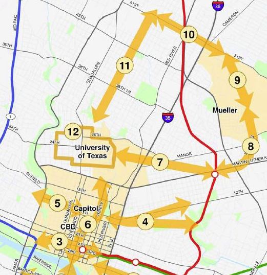
Closeup of City’s Central Austin Transit Study map, showing core, potential rail corridors, and City’s version of route to “North Central Austin” (Hyde Park via Speedway). Guadalupe-Lamar was avoided. Map: Snip from COA document.
♦
By Lyndon Henry
In this blog and other forums, for months I’ve been making the case that Project Connect’s urban rail study has not been considering actual travel corridors, but rather large tracts of urban land more aptly described as sectors. Actual travel corridors haven’t just been ignored, they’ve been severed and segmented, so that effective evaluation of them for rail transit routes has been impossible. (The best example is Guadalupe-Lamar, for which Project Connect cut off the head — the core area — and then severed the legs — any extensions north of Crestview.)
Project Connect has supposedly been focusing on possible urban rail routes in the center of the city, so it designated a huge central-city study area — implausibly calling it the “Central Corridor”, although it had none of the characteristics of an actual urban travel corridor. (See Project Connect’s “corridor” study without corridors!)
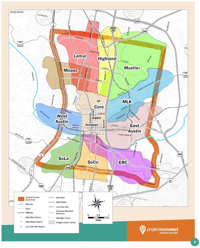
Project Connect’s “Central Corridor” (study area) with “sub-corridors” (i.e., sectors). (Click to enlarge.)
As one can see in the map above, within this huge central study area, Project Connect then carved up a number of major study districts — which it then labeled “sub-corridors” (since the entire center of the city was now labeled a “corridor”). Rather than actual travel corridors — which are what you’d need to study fixed transit facilities like urban rail — these subdivisions are, in effect, huge, sprawling sectors of the center-city, mostly comprising several square miles. “Mueller”, for example, reaches out of the Mueller development site to reach central neighborhoods west of I-35, and north to gulp up most of Northeast Austin.
But local officials definitely know what real corridors are. As recently as 2010, the City of Austin, in collaboration with its consultant URS Corporation, produced the Central Austin Transit Study (CATS) — the pre-eminent initial feasibility study for a central Austin urban rail system. And, as the map below shows, they didn’t dither around with huge, arbitrary, misnamed blobs of urban land … they examined actual corridors:
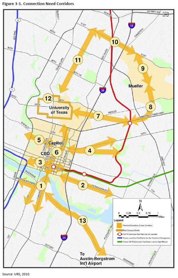
CATS map of actual potential rail corridors studied. Map: COA and URS.
However, then, as now, the basic aim was to justify a Phase 1 urban rail route through the east side of the UT campus and on out to the Mueller redevelopment site. So the study and the map of selected corridors were cleverly contrived to confine and steer the study in the “proper” direction.
In particular, notice how the City planning team studiously avoided the most obvious route going north from the campus — up Guadalupe and North Lamar. Instead, Corridor #11 is fashioned as “University of Texas (UT) to North Central Austin (Hyde Park)”, and directed up Speedway (a minor arterial that’s almost a neighborhood street) as far as 51st St. And of course, it’s purpose is to make a connection to … Mueller!
But manipulating the routes was only half the game. The other half was manipulating the evaluatory methodology.
For the 2010 study, that was a lot simpler than now. Instead of “gerrymandering” data, playing with projections and hypothetical growth rates, and assigning heavy freeway traffic to relatively quiet neighborhoods, the City and URS team in 2010 just devised a simple, subjective 1-2-3 rating system that allowed them to assign a subjective “score” at whim to the various corridors. And whaddaya know … Mueller won!
But the point is that more or less real travel corridors were studied in 2010, although they were shaped and located to fit the outcome desired by top officials. So local planners do know what real corridors should look like.
And it’s real travel corridors that Project Connect’s urban rail study should have been scrutinizing and evaluating all along. That’s what the Austin community deserves. Instead, what Austin has gotten so far is another exercise in smoke-and-mirrors “planning” intended again to achieve a desired outcome.


[…] the debate continues online. Blogs like Austin Rail Now continue to question Project Connect’s recommendation. What do you think about Project Connect’s […]