Posts Tagged ‘LRT’

h1

Success at last! Austin votes to install light rail system

30 November 2020

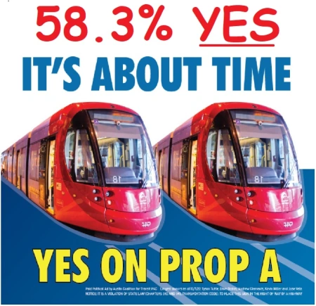
Campaign poster for Austin’s Proposition A transit ballot measure, showing LRT trains, with annotation after Nov. 3 victory. ACTPAC graphic, annotated by ARN.

It’s taken over 40 years of proposals, planning, debate, defeats, and delays, but finally, on 3 November 2020, despite the daunting challenges of the global Covid-19 pandemic and massive economic crisis, 58.3% of Austin voters approved a $7.1 billion major transit upgrade and expansion to the Capital Metro (transit authority) system, including a New-Start electric light rail transit (LRT) system for the city. For the initial starter system, two lines are proposed, intersecting in a downtown subway tunnel. About 45% of the capital funding is expected to come from the U.S. Federal Transit Administration. To cover the local 55% share, even in these hard times, voters okayed a modest increase in the local property tax ($0.0875 per $100 valuation).

At long last, this amazingly successful vote redeems the very narrow failure of Capital Metro’s LRT vote in 2000. While that plan received a majority of City of Austin votes, it failed by less than 2000 total votes in the more suburban and rural parts of Capital Metro’s service area. In contrast, the 2020 ballot measure involved City of Austin voters (and City bonding authority) only, receiving a comfortable majority margin of eight percentage points. Ironically, the Orange Line component of the LRT plan just approved is, in large part, a replication of the central North-Lamar-to-South-Congress alignment proposed in the 2000 plan!

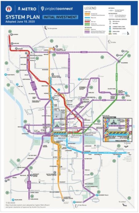
This latest vote, for the ballot measure identified as Proposition A, also approved not just light rail, but a massive increase in Austin’s overall transit system, including an upgrade of the bus network with improved service frequency plus new “bus rapid transit” (more the “light” variety than the full, capital-heavy type); conversion to an all-electric bus fleet; a citywide on-demand pickup/circulator bus/van system; and an upgrade and expansion of the MetroRail light regional railway service, operated with diesel-multiple-unit (DMU) rolling stock compliant with Federal Railroad Administration “heavy” mainline railroad standards. In the map below, the proposed new LRT lines are shown in orange (gold) and light blue; the “BRT” lines are purple; the existing MetroRail line is red, and the new MetroRail line is green.


Map shows system plan of public transit system approved by Austin voters on Nov. 3rd. Graphic: Project Connect.


The basic anchor of the planned LRT system is the Orange Line, which will create a powerful public transport backbone along the crucial North Lamar-Guadalupe-South Congress travel and urban development route – Austin’s heaviest-traffic, highly developed, and most centrally positioned major local corridor. For background, the importance of this corridor, and the decades of intensive, agonizing public interest, studies, hopes, indecision, deliberations, and proposals concerning it, are described in ARN’s 2015 report, Long saga of Guadalupe-Lamar light rail planning told in maps. For additional background on the importance of this corridor, also see: Latest TTI data confirm — Guadalupe-Lamar is central local arterial corridor with heaviest travel and Guadalupe-Lamar urban rail line would serve 31% of all Austin jobs

The initial alignment of the Orange Line is planned to stretch from the North Lamar Transit Center (NLTC) at U.S. 183 and North Lamar, southward down Lamar, then Guadalupe, and into a downtown subway with a major underground hub at Republic Square (W. 4th St.). Continuing south, the subway is currently proposed to extend under the Colorado River (locally known as LadyBird Lake). Emerging back to the surface, it would proceed in the median of South Congress southward to a provisional terminus at Stassney Lane. The longer-range plan entails extending this line north to Capital Metro’s transit hub at Tech Ridge, and southward to a new multi-modal center at Slaughter Lane/Southpark Meadows.

The Blue Line, to be developed concomitantly, would interline with the Orange Line from the NLTC into the downtown subway. At the Republic Square junction, the Blue Line would branch eastward, running in its own short tunnel a few blocks to a proposed Downtown Station. Emerging from the subway, it would then head across the river on a new multi-modal bridge. It would then turn eastward again, following East Riverside Drive and other alignments to reach a terminal at the ABIA Airport

Preliminary tunnel construction plans have envisioned using the cut-and-cover method. However, geometric and engineering constraints and subsurface conditions may favor the use of deep boring. For rolling stock, planning has assumed peak four-car consists of articulated electric LRT vehicles. For the Orange Line alone, ridership in excess of 85,000 per day has been forecast for the year 2040 in systems-level planning.

Vigorous grassroots community involvement has been key to the successful outcome of Austin’s long-recognized need for urban rail. A persistent campaign spearheaded initially by the Texas Association for Public Transportation in the 1970s, joined in the 2000s by the Central Austin Community Development Corporation (CACDC), gradually mobilized a coalition of local activists and organizations to maintain an unrelenting public focus on the need for an LRT system anchored in the North Lamar-Guadalupe-South Congress corridor. To its great credit, Capital Metro’s planning program, Project Connect, mounted a massive community outreach program, reaching tens of thousands of individuals throughout the city, and created the Project Connect Ambassadors Network (PCAN), involving dozens of key community activists who met monthly to interact with the official planning team, inputting ideas and helping shape the development of the final plan.

During the election campaign the official campaign leadership and planning team, organized as Transit for Austin and the Mobility for All PAC, managed a well-run, aggressive, consistent, and effective public involvement and media campaign that certainly played a crucial role in achieving this victory. This was bolstered by other community efforts, particularly the Austin Coalition for Transit PAC (ACTPAC).

All in all, Austin’s LRT New Start achievement is an amazing leap forward for a concept that started with the vision and aspirations of a few community activists in the 1970s. These early dreams and hopes led them to catalyze the effort to create a transit authority in the mid-1980s; to persevere through the narrow LRT plan defeat in 2000; to inspire and attract additional community support; to reject the flawed plan in 2014; and finally to soldier on to an astonishing success for a widely supported multi-line LRT system in this otherwise catastrophic year.

h1

“Future-Proof” Austin’s Mobility With Urban Rail — Not Infrastructure for Techno-Fantasies

29 July 2019

Orange Line (north-south route indicated within black outline) shown within Project Connect’s map of proposed regional system. Excerpted and edited by ARN.


By Austin Rail Now

Commentary originally produced by ARN and distributed (as one-page handout) to participants in Project Connect’s Orange Line Workshop at Austin Central Library, 17 July 2019.

♦ Light rail transit (LRT) — This well-proven, widely deployed, effective, affordable urban rail alternative has been proposed for the Orange Line (N. Lamar-Guadalupe-S. Congress) corridor for 30 years. Since selected as Capital Metro’s Locally Preferred Alternative in 1989, LRT has remained Austin’s premier major high-capacity transit vision. In early 2018, Project Connect 2’s proposal for LRT in the Orange Line corridor received widespread community acclaim. However, the proposal was subsequently quashed by Capital Metro, which proceeded to restart the Project Connect process.

As noted below, LRT has demonstrated numerous key advantages over bus rapid transit (BRT). And unlike many “gadget” alternatives, LRT is well-proven in public service, a readily available technology, and non-proprietary. (In contrast, “autonomous BRT” has been neither deployed commercially nor even tested.)

♦ Ridership — On average, light rail systems have excelled in attracting passengers, especially new riders who have access to a car but choose to ride LRT. Compared with buses, LRT systems are more user-friendly, more comfortable to access and ride, and perceived as safer and more reliable. On average, ridership on new LRT systems is 127% higher than on bus rapid transit (BRT).
http://www.lightrailnow.org/industry_issues.htm#ridershiphttp://www.lightrailnow.org/industry_issues.htm#mode-preference
APTA/NTD

♦ Affordability — Especially for a city of Austin’s size, light rail has typically provided an affordable capital cost opportunity to install urban rail (costs similar to “real” BRT), with significantly lower operating + maintenance cost per passenger-mile compared to buses. Average operating cost of new LRT systems is 10% lower than for BRT. The lower capital and operational costs of a predominantly surface LRT system make it the ideal affordable mode for future expansion of a rail transit network throughout the Austin metro area.
http://www.vtpi.org/bus_rail.pdfNational Transit Database


Average operational cost of LRT is 10% lower than for BRT. Average costs calculated by ARN from data reported to National Transit Database, 2016.


♦ Environment & energy — Evidence shows LRT systems have the lowest air pollution and noise impacts, preserve neighborhoods and urban quality of life, and reduce energy usage per passenger-mile compared with cars and buses. LRT especially avoids the energy-wasting effects of hysteresis and asbestos pollution of rubber-tire transport.
http://www.lightrailnow.org/industry_issues.htm#environmental-impactshttp://onlinepubs.trb.org/onlinepubs/circulars/ec145.pdf

♦ Urban benefits — In contrast to bus operations (including BRT), light rail systems have demonstrated a consistent, significant, superlative propensity to attract adjacent development and economic growth, and help shape and guide a changing urban landscape.
http://www.lightrailnow.org/industry_issues.htm#urbanhttp://onlinepubs.trb.org/onlinepubs/Conferences/2019/LRT/LyndonHenry.pdf

♦ Capacity — Compared to both buses and “gadget” modes, LRT has far higher capacity in normal service scenarios and greater capability to accommodate future demand.
https://www.thoughtco.com/passenger-capacity-of-transit-2798765

♦ Guadalupe-Lamar (G-L) corridor — Positioned as Austin’s major central local corridor, between I-35 to the east and Loop 1 (MoPac) to the west, G-L has repeatedly been regarded as ideal for an LRT surface starter line (with no need for major civil works) to create the key central spine for an eventually citywide and regional urban rail network. It’s the center city’s 3rd-heaviest north-south corridor. The City of Austin (COA) has repeatedly emphasized that G-L is the primary local traffic corridor in central-city Austin, with exceptionally heavy traffic at maximum capacity for over the past 2 decades. Texas Transportation Institute ranks North Lamar as one of the most congested arterials in Texas. Urban rail is essential to maintaining mobility in this crucial corridor.
https://austinrailnow.com/2014/10/13/latest-tti-data-confirm-guadalupe-lamar-is-central-local-arterial-corridor-with-heaviest-travel/

♦ Employment & population density — With Austin’s highest total employment density on Guadalupe-Lamar, an urban rail line could serve 31% of all Austin jobs. An urban rail line in this corridor would serve the highest-density residential concentrations in the city — including the West Campus, ranking as the 3rd-highest in residential neighborhood density among major Texas cities.
http://centralaustincdc.org/transportation/austin_urban_rail.htm

h1

Another possible design for light rail in Guadalupe-Lamar corridor

30 January 2016
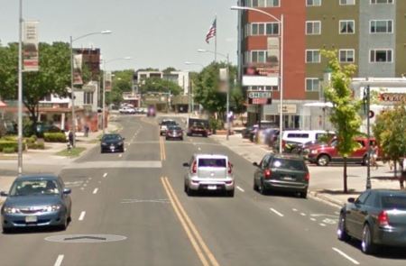
Guadalupe St., near W. 28th St. Graphic: Google Street View.

Guadalupe St., near W. 28th St. Graphic: Google Street View.

As Austin Rail Now has repeatedly pointed out, there are various ways that a starter light rail transit (LRT) line could be fitted workably into the Guadalupe-Lamar corridor. In our December 2014 article «San Francisco’s N-Judah Muni Metro line shows design option for light rail in Austin’s Guadalupe-Lamar corridor» we suggested a design alternative with the objective of inserting dedicated LRT lanes while minimizing disruption and cost and maintaining four traffic flow lanes. In this, we showed how a San Francisco LRT design could serve as a model for installing a dedicated LRT alignment in the relatively narrow 80-foot width of the Guadalupe-Lamar corridor (see illustrations below).
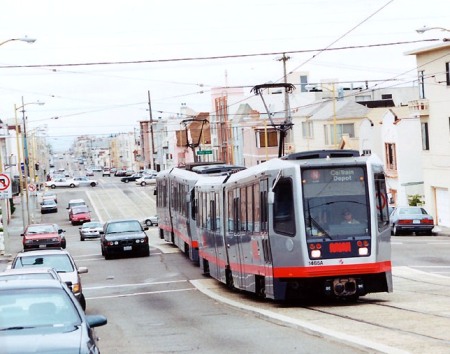

Muni Metro light rail

San Francisco’s N-Judah LRT line could serve as design model for Austin’s Guadalupe-Lamar corridor. Photo (copyright) Eric Haas.
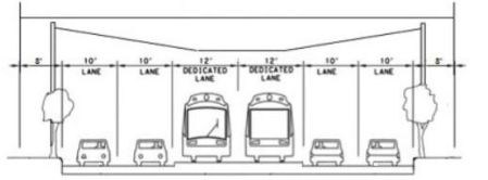

Cross-sectional diagram

ARN’s proposed design shows how LRT, plus 4 traffic lanes and pedestrian/bicycle facilities, could be fitted into relatively narrow Guadalupe-Lamar corridor. Graphic: ARN. (Click to enlarge.)


This past December, another design proposal was made public by Austin community urban activist and Guadalupe-Lamar rail transit supporter Andrew Mayer. Compared to Austin Rail Now’s relatively minimalist approach, Andrew’s design is considerably more ambitious — with undoubtedly more urban impact and capital expense — but it embodies good ideas and hints at the kind of range of optional approaches available to ensure that LRT will work in this key central corridor.

As Andrew explains, “For those who are interested in urban rail along Guadalupe and Lamar … I made a bunch of detailed cross-sections with streetmix several months ago.’ These are posted on the Imgur online image sharing community and image host site: http://imgur.com/a/gsa2n. In this post, we’ll illustrate Andrew’s proposal with sample graphics selected excerpted from his presentation. (Occasional stations are selected to illustrate typical proposed station design.)

Complete Streets approach

While almost any design proposing insertion of dedicated lanes for LRT into this corridor would represent to some extent a Complete Streets approach, Andrew’s proposal seems to be a particularly large-scale and aggressive implementation. As he elaborates,

I feel like these designs are relatively ambitious (2 transit lanes, 4 auto lanes, 2 separated bike lanes, 2 12 ft sidewalks along most of its length), but revamp Guadalupe and Lamar into more complete streets, while seeing if I could retain the existing number of auto lanes. Some of these ideas I came up with way back in 2009 (i.e. the split direction of traffic along west campus, the wide boulevard between 38th and 51st st), some are more recent.

Regardless how much you agree or disagree with these designs, I hope this contributes to the discussion of rail on Guadalupe/Lamar, as I feel like detailed discussion of street design is warranted if there is going to be a push to get [Guadalupe/Lamar/Congress] urban rail on the ballot as soon as possible.

Illustrating this approach is Andrew’s proposal for making the Drag more hospitable to LRT, pedestrian, and bicycle traffic by moving southbound traffic off of Guadalupe and onto either Nueces or “possibly” San Antonio St. (see map below). Andrew notes that “Relatively slow traffic (25 mph) due to traffic calming measures … makes street pedestrian friendly despite higher traffic volumes.”
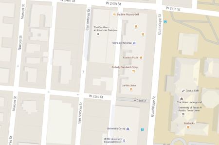

Map snippet shows Guadalupe St. at right (east), with University of Texas campus bordering on east side; San Antonio and Nueces St. in West Campus neighborhood (west of Guadalupe). Graphic: Google Maps. (Click to enlarge.)

Map snippet shows Guadalupe St. at right (east), with University of Texas campus bordering on east side; San Antonio and Nueces St. in West Campus neighborhood (west of Guadalupe). Andrew Mayer’s design proposes moving southbound traffic from the Drag onto either Nueces or San Antonio. Graphic: Google Maps. (Click to enlarge.)
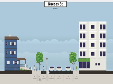

Proposed southbound traffic moved from Guadalupe to Nueces St. Graphic: Andrew Mayer. (Click to enlarge.)

Proposed southbound traffic moved from Guadalupe to Nueces St. Graphic: Andrew Mayer. (Click to enlarge.)


The Drag (West Campus)

As illustrated below, Andrew’s proposal for the main Drag segment (bordering the West Campus neighborhood) seems to envision dedicated LRT lanes occupying the west side of the street (former southbound lanes, with traffic now moved to either Nueces or San Antonio St.). Traffic lanes are narrowed to 10-ft width. Andrew comments: “Bike lane stays pretty much the same, but the parking lane and current southbound lanes are used for transit lanes. Northbound lanes are pushed slightly westward to allow for a separated bike lane and wider sidewalk.”
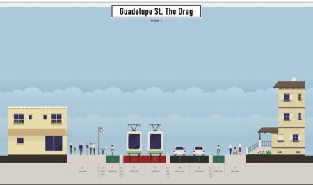

Proposed LRT alignment along Drag. Graphic: Andrew Mayer. (Click to enlarge.)

Proposed LRT alignment along Drag. Graphic: Andrew Mayer. (Click to enlarge.)


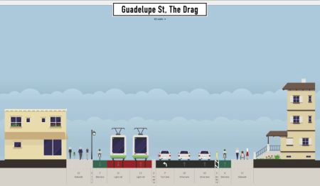
In this proposal, space for station platforms appears to be appropriated from pedestrian/bike space. It’s not explicit in Andrew’s design, but station platforms would likely be staggered across intersections (a common space-conserving technique in LRT design). Andrew also suggests that “platform” space might be allocated to use as a turning lane for motor vehicles (although this could conflict with the need for a station platform at that same point). Another option, deployed in Houston Metro’s MetroRail LRT design, is to allow a turn lane to share the LRT track (with traffic signal control coordinated with train movements — discussed briefly in our article «Houston’s MetroRail shows the way — How to fit urban rail into Austin’s Guadalupe and Lamar»).

Andrew comments that “In this design, there are two platforms and both open on the right side of the vehicle.” Andrew also suggests the possibility that “the idea was that some buses would also use the transit lanes (i.e. 803, 3, other bus lines that feed onto Guadalupe) and thus the right-hand platforms would be compatible with buses that only have doors on the right-hand side.” However, while sharing of lanes between buses and LRT is entirely possible and done in some situations, sharing where there is high-frequency service by both modes is not advisable. (Our own design proposed center-street running with allocation of at least a single curbside lane on each side for local bus access.)
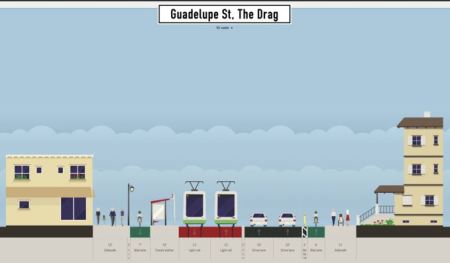

Proposed 24th St. station (southbound direction). Graphic: Andrew Mayer. (Click to enlarge.)
Proposed 24th St. station (southbound direction). Graphic: Andrew Mayer. (Click to enlarge.)


Proposed LRT alignment on Drag at 24th St., with possible turning lane. Graphic: Andrew Mayer.(Click to enlarge.)

Proposed LRT alignment on Drag at 24th St., with possible turning lane. Graphic: Andrew Mayer.(Click to enlarge.)


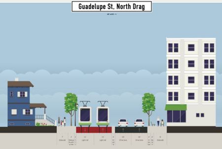
Between 24th and 29th St. (Andrew calls this the North Drag), Guadalupe narrows somewhat, constricting the space for LRT as well as pedestrian and bike facilities (see streetview at top of post, and aerial view, below). Andrew’s solution is to rely on the fact that southbound traffic has been re-routed to other streets; he also narrows the sidewalks and assumes that the bicycle route can be re-routed through this section to an available parallel street (Hemphill Park).
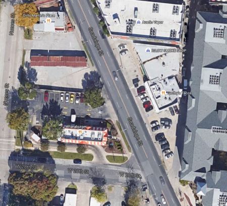

Aerial view of most constricted section of Guadalupe-Lamar corridor, between 24th-29th St. Graphic: Google Earth. (Click to enlarge.)
Aerial view of most constricted section of Guadalupe-Lamar corridor, between 24th-29th St. Graphic: Google Earth. (Click to enlarge.)


Proposed LRT alignment in narrow segment of Drag between 24th-29th St. Graphic: Andrew Mayer. (Click to enlarge.)

Proposed LRT alignment in narrow segment of Drag between 24th-29th St. Graphic: Andrew Mayer. (Click to enlarge.)


Central Guadalupe segment

To insert the LRT alignment in the relatively narrow segment of Guadalupe between 29th and 38th St., Andrew’s option seems to eliminate a traffic lane, although he assumes a turning lane in some cases. (With ROW assumed at 100 feet or more, Andrew’s plan would seem to require additional property acquisition in this section.)
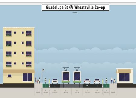

Proposed LRT alignment in narrow segment of Guadalupe between 29th-38th St. Graphic: Andrew Mayer. (Click to enlarge.)
Proposed LRT alignment in narrow segment of Guadalupe between 29th-38th St. Graphic: Andrew Mayer. (Click to enlarge.)


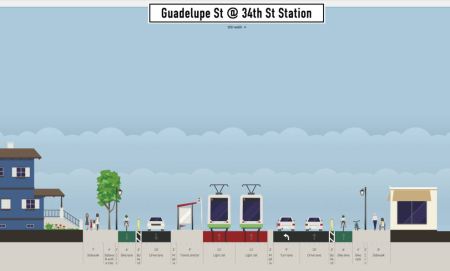
Proposed 34th St. station (platform for southbound direction shown). Graphic: Andrew Mayer. (Click to enlarge.)

Proposed 34th St. station (platform for southbound direction shown). Graphic: Andrew Mayer. (Click to enlarge.)


At West 38th St. (shown in a Google Street View below), Andrew apparently proposes a short subway section, commenting “The transit lanes plunge beneath the street in a shallow cut-and-cover tunnel (basically an underpass) so there can be turning lanes for NB auto traffic without expanding the road’s ROW [right-of-way]….” Technically, this is possible — but quite an expensive feature, particularly since a station for this important east-west arterial would certainly be justified (and a subway station would add a considerable capital expense).
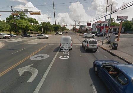

Street view of Guadalupe at 38th St. intersection. Graphic: Google Street View. (Click to enlarge.)

Street view of Guadalupe at 38th St. intersection. Graphic: Google Street View. (Click to enlarge.)


Our own design (which avoids any heavy civil works) assumes that LRT, like MetroRapid buses and ordinary traffic, would simply continue to operate through the W. 38th St. intersection at-grade, following the current surface street profile. Nevertheless, Andrew’s tunnel proposal indicates that there are indeed other options in the planning toolbox that could be considered to address engineering, political, or other concerns.

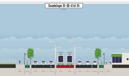
North of W. 38th St., for about eight blocks (to W. 45th St.) this section of Guadalupe is bordered on the east by leafy established neighborhoods such as Hancock and Hyde Park, and on the west by the publicly owned State of Texas property of the Department of Mental Health and Mental Retardation (MHMR, including the Austin State Hospital). Andrew proposes that a narrow strip of this public property be allocated for widening of the Guadalupe ROW, thus facilitating an LRT alignment: “Between 38th and 45th St, about 15 feet of feet from the [public property] is acquired to expand the ROW to 120 feet, allowing for an 2 bike lanes, 2 transit lanes, 4 auto lanes, and a parking lane or left turn lane, and 2 10 ft sidewalks.” Andrew suggests such a transfer of state land to the city would be plausible and workable “because the existing space is basically used for fields, some interior roads, and power lines, all of which can be moved/replaced relatively easily.”
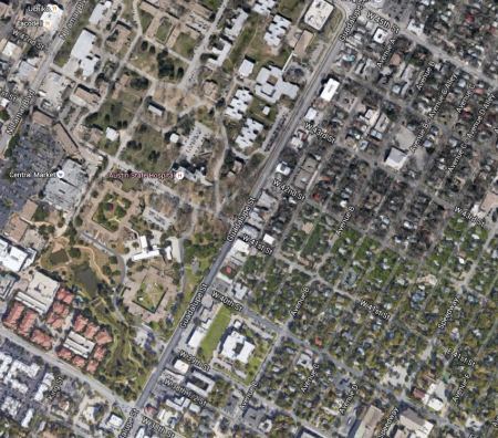

Aerial view of section of Guadalupe St. between 28th-45th St., showing MHMR bordering on west and established residential neighborhood on east side. Graphic: Google Earth. (Click to enlarge.)
Aerial view of section of Guadalupe St. between 28th-45th St., showing MHMR bordering on west and established residential neighborhood on east side. Graphic: Google Earth. (Click to enlarge.)


Proposed LRT alignment in segment of Guadalupe between 38th-45th St. Graphic: Andrew Mayer. (Click to enlarge.)

Proposed LRT alignment in segment of Guadalupe between 38th-45th St. Graphic: Andrew Mayer. (Click to enlarge.)


Use of this property in this manner as part of an LRT alignment has been proposed in various studies and propositions over the past 25 years. The day is surely coming when the State will seek to divest itself of this property, perhaps to private interests, so if an easement for ROW expansion is to be procured, official planning and action would seem urgent. Yet no public body, particularly neither Capital Metro nor the City of Austin, has taken a single official step toward this goal in all the years the idea has been on the table.

In the section north of W. 45th St. West Guadalupe St. branches off Guadalupe to connect with N. Lamar Blvd., forming the Triangle area (see map below). West Guadalupe provides a wider ROW here, and is followed by the LRT route, as shown in Andrew’s design, also below. Andrew comments that “Like in the 38th-45th portion, state land would be acquired (basically fields) to expand the roadway. In this case, the northbound auto and bike lanes would be just east of the existing oak trees next to Guadalupe.”
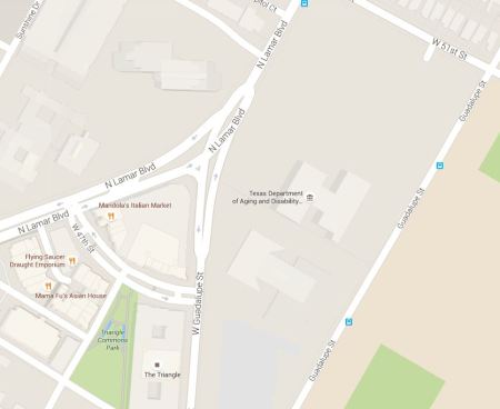

Map snippet shows West Guadalupe St. joining North Lamar at triangular land section now known as "the Triangle". Graphic: Google Maps. (Click to enlarge.)

Map snippet shows West Guadalupe St. joining North Lamar at triangular land section now known as “the Triangle”. Graphic: Google Maps. (Click to enlarge.)
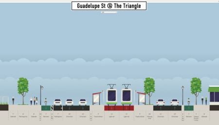

Proposed LRT alignment past Triangle, with station. Graphic: Andrew Mayer. (Click to enlarge.)

Proposed LRT alignment past Triangle, with station. Graphic: Andrew Mayer. (Click to enlarge.)


North Lamar segment

Having transitioned to North Lamar, the alignment with Andrew’s proposed design would seem to require acquisition of more ROW to accommodate a cross-section width of 115 feet for pedestrian and bike facilities, landscaping, and buffer zones (see typical cross-section, below).

As Andrew subsequently explains,

The expanded roadway would work by turning the parking spaces in front of businesses into larger sidewalks and bike lanes. Parking lanes would be put in between the auto lanes and bike lanes where possible to allow for some parking capacity. I HIGHLY recommend doing a study of the traffic going to businesses along this section of N Lamar. How many customers can access the business by foot/bike/transit? For those who have to drive, is there enough parking on the street or behind the business?

Andrew notes that “Interestingly, this section of Lamar Blvd is one of the study areas for CodeNEXT [current process revising Austin’s land-use regulations], so perhaps there is data available there.”

Andrew’s wide streetscape design (which undoubtedly would require extensive and costly adjacent property acquisition) contrasts with our own narrower design proposal which assumed insertion of LRT within existing public ROW (except at intersections with stations, where modest widening would occur). There’s no question that widening North Lamar with amenities such as Andrew has suggested would create a significantly enhanced environment for the public. The issue here is whether it should be included in the initial starter line design, or proposed as a later major upgrade to the corridor.
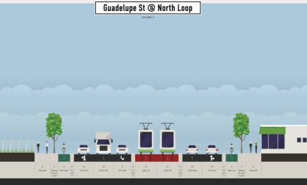

Proposed typical LRT alignment in North Lamar. Graphic: Andrew Mayer. (Click to enlarge.)

Proposed typical LRT alignment in North Lamar. Graphic: Andrew Mayer. (Click to enlarge.)


For a station at the intersection of North Lamar with the major east-west arterial Koenig Lane (shown below), Andrew remarks that “Large parking lots in the shopping center, unused TxDOT land (that was going to be used for freeway along [Koenig] Ln), and fields along the DPS building could all be acquired to make a full-sized boulevard next to [Koenig] Ln.”
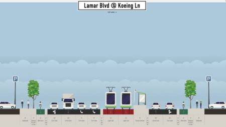

Proposed Koenig Lane station (platform for northbound direction shown). Graphic: Andrew Mayer. (Click to enlarge.)

Proposed Koenig Lane station (platform for northbound direction shown). Graphic: Andrew Mayer. (Click to enlarge.)


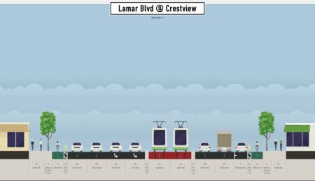
Andrew’s designs terminate at Crestview — a major and rather complex nexus, with the heavily used Airport Blvd. intersecting and the MetroRail Red Line rail transit route crossing North Lamar, parallel to Airport (see aerial view, below). Maintaining a 115-ft ROW assumption, Andrew provides a surface LRT design, shown further below; although an interchange station would be essential here, none is presented. Calling his surface design “Alternative 1”, Andrew explains that “Transit lanes stay at grade, there are only 2 instead of 3 NB auto lanes, and the sidewalks are only 12 ft wide each.”
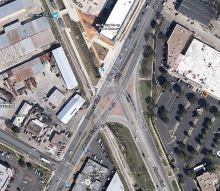

Aerial view of complex intersection of North Lamar with Airport Blvd. and Red Line alignment. Graphic: Google Earth. (Click to enlarge.)
Aerial view of complex intersection of North Lamar with Airport Blvd. and Red Line alignment. Graphic: Google Earth. (Click to enlarge.)


Proposed typical LRT alignment at Crestview. Graphic: Andrew Mayer. (Click to enlarge.)

Proposed typical LRT alignment at Crestview. Graphic: Andrew Mayer. (Click to enlarge.)


Andrew also proposes an “Alternative 2” in which “Transit lanes and the station go into a cut-and-cover tunnel beneath the auto lanes.” He acknowledges that such a subway would be “More expensive and complex to construct, but retains the same number of NB auto lanes and allows for wider sidewalks and more parking.” Andrew indicates a preference for his first alternative, keeping LRT on the surface.

Austin Rail Now believes that an initial surface starter LRT line could safely and efficiently operate through the Crestview intersection as it basically exists. Ultimately, however, some method of grade separation at this complicated intersection may be prudent. We believe this should involve either tunneling or elevating (or both) the motor vehicle trafficleaving the surface to transit, pedestrians, and bicycles. Not only is this approach more compatible with a livable, walkable environment, but it also recognizes that there is many times greater funding available, from all sources, for roadways, while transit is strapped for resources.

Summing up

Considering both our own design proposal and Andrew Mayer’s more ambitious approach, our thoughts return to the controversy over Project Connect’s ill-fated urban rail planning process and proposal that emerged through the fall of 2013 and eventually crashed and burned in the November 2014 vote — in particular, the expressions of skepticism, utter hopelessness, deficit of vision, and outright hostile resistance voiced by several members of the Central Corridor Advisory Group (CCAG) and Austin City Council in their efforts to disparage and dismiss the possibility of installing LRT in the Guadalupe-Lamar corridor. Fortunately, that nonsense (whether based on misunderstanding, ignorance, or cynical political sniping) has mostly evaporated.

Between the two designs now already on the table, it’s possible to see that in reality a broad range of alternatives and design options is available to make this happen. It’s neither impossible nor astronomically expensive. We believe our “minimalist” design is the most immediately affordable, workable, and attractive to voters and the public at large — but that’s just our assessment; we strongly believe all options are worth considering.

It’s time to end Austin’s long saga of indecision, conflict, bumbling, bungling, and diddling. Guadalupe-Lamar is truly the city’s strongest “central corridor”, by far the most logical backbone for a light rail transit starter line. The major task at hand is mustering the community and political will to bring an LRT project here to fruition. ■
h1

Viewpoint: Community action must clean up public agencies’ transportation planning mess

1 February 2014
Traffic congestion on North Lamar on morning of Jan. 27th, first day of full MetroRapid service. MetroRapid "rapid transit" bus can be seen in far distance at rear of traffic queue. Photo: Steve Knapp.

Traffic congestion on North Lamar on morning of Jan. 27th, first day of full MetroRapid service. MetroRapid “rapid transit” bus can be seen in far distance at rear of traffic queue. Photo: Steve Knapp.

By Mary Rudig

Mary Rudig is a Gracy Woods Neighborhood Association coach and editor of the North Austin Community Newsletter.

While I honestly don’t think it’s intentional, what I see in the recent developments with Project Connect is that Capital Metro and our transportation “experts” are continuing the same pattern government entities have always followed. Somebody at the top gets fixated on an idea, and that becomes the top-down policy for everything to do with transportation. Any thinking outside of the box is strongly discouraged.

When I moved to Austin in 1992, there was a fixation on downtown and all policy was designed to support this. Every bus route had to go downtown, and cross-connections, going around downtown to better connect destinations, and supporting the jobs/growth in the outer ring, were discouraged. This was followed by a series of other fixations — there was a change at the top, and Capital Metro became fixated on rail, going from one plan to another plan. Then came the fixation with the park-and-rides, and the Domain, and moving people from one activity node to another activity node (remember those days?). Then the fixation switched back to moving people to downtown. Again.

Now we have Project Connect, and the latest fixation is with bus rapid transit (BRT) and New Urbanism. New Urbanism will magically create a boom of jobs and housing east of I-35 very, very soon. BRT is the magic pixie dust that City Council has been looking for to fix all our woes. And all this is great — until 2015 when the new City Council takes over and another idea is put forward to be the new magic pill.

The problems though, are the same.

North Lamar/Guadalupe, the backbone of our city, is congested and constrained.

• The outer ring of neighborhoods don’t want to go to downtown, they want to go to their jobs and make cross-connections.

• The other cities in Central Texas need to get people into Austin, in a cost-effective way that won’t put a too high burden on them, because they are struggling to balance their growth needs with a tax base that just isn’t big enough yet.

• Large employers are not being held responsible for assisting with transportation solutions, such as providing shuttles and park and ride space, scheduling shifts away from peak times, flexing workers to work from home/remote offices, etc.

• The high-tech/IT jobs at the north end need more mixed transportation, and most of that transportation need is east-west.

• Many service workers are living either east of I-35 or moving to outlying communities because of the lack of affordable housing, and these populations need better transportation to get to their jobs, which again, are usually not downtown.

• We have huge gaps in how we are serving student populations outside of UT. We have absolutely no idea what the students at our vocational and smaller colleges need in the way of transportation because nobody has asked. ACC’s idea — to rotate campus populations in and out of Highland, so they can close and remodel other campuses — is both brilliant, and a transportation nightmare waiting for a place to happen.

• We are a city of small businesses, but we have barely cracked the shell with what this population needs. 80% of the city works for small business. Think about that — we don’t honestly know where 80% of our workers want to go, transportation-wise. The only study I know of that touches on this issue is the 2012 transportation study by Austin Chamber of Commerce.

• We must connect the urban core in North Austin to the urban core downtown, while figuring out a better way to shuttle people in and out of both of these cores.

Major North Austin neighborhoods. Map: LoveNorthAustin.com.

Major North Austin neighborhoods. Map: LoveNorthAustin.com.

I think Scott Morris (Central Austin Community Development Corporation) and Lyndon Henry (Light Rail Now Project) have made a good start — pick the spine, explore if we can fix it with rail or not, and then maybe we can use the coalition we have built to begin to address these other issues.

Capital Metro and CAMPO and the rest are never going to get their act together, people, because they are too busy worrying about the latest directive from the top. So it’s up to us to fix the mess they have made.

h1

How urban rail can be installed in the Guadalupe-Lamar corridor

10 October 2013
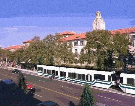
Except for the the somewhat clunkier styling of the railcars, this 2000 simulation of what light rail transit might look like on the Drag is not that different from one of the options today. Graphic: Light Rail Now collection.

Except for the the somewhat clunkier styling of the railcars, this 2000 simulation of what light rail transit might look like on the Drag is not that different from one of the options today. Graphic: Light Rail Now collection.

by Lyndon Henry

Some supporters of the Guadalupe-Lamar (G-L) corridor for Austin’s urban rail starter line have been seeking details about how urban rail (i.e., light rail transit, or LRT) would be installed in these thoroughfares — running in mixed traffic, in reserved lanes, or how? At about the same time, proponents of the Official (aka City of Austin-Capital Metro) proposal for an urban rail line from downtown to Mueller have recently begun raising the issue of right-of-way (ROW) constraints in this same G-L corridor.

It’s important to keep in mind that the Mueller proposal itself has its own ROW constraints and other challenges, but I think it would be helpful here to address some of the issues in the G-L corridor. One of the reasons for this is that I’m not convinced that all parties in the Project Connect team will necessarily make a good-faith effort to find a truly workable, affordable design for inserting urban rail into the G-L thoroughfare alignments — and advocates need to be prepared to insist that valid (and proven) alternatives be examined.

The basic idea is for urban rail (light rail transit, LRT) to operate totally, or almost entirely, in its own lanes. This would require some reconstruction of Lamar Blvd. and probably Guadalupe St. in sections, including slight narrowing of existing lanes, elimination of the turning (“chicken”) lane and replacement with transit-integrated traffic controls (such as left turn lanes), and other measures. Light rail systems in places like Portland, Dallas, Houston, Phoenix, Denver, Salt Lake City, etc. are models for this.

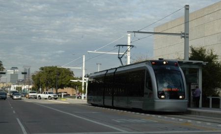
Having crossed intersection, Houston LRT train accesses station on Fannin St. as traffic control system allows queue of motor vehicles to make left turn over track reservation behind it.

Having crossed intersection, Houston LRT train accesses station on Fannin St. as traffic control system allows queue of motor vehicles to make left turn over track reservation behind it. Photo: Peter Ehrlich.

Also keep in mind that Project Connect’s longer-range plan for buses on Lamar-Guadalupe is to install tens of millions of dollars’ worth of reserved lanes — so official planners are already prepared to bite a bullet on this basic issue. What advocates of urban rail in the G-L corridor are saying is that it makes a lot more sense to install reserved lanes for rail rather than buses.

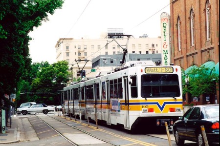
It’s possible that there might be a short section of LRT in mixed traffic (one or both tracks). Sacramento’s LRT operates with this kind of compromise (for about a mile along 12th St., approaching the city’s downtown from the northwest), and has done so for the past 26 years — see Advantages of Light Rail in Street Alignments.
https://austinrailnow.wordpress.com/2013/04/22/advantages-of-light-rail-in-street-alignments/

Sacramento's LRT shares one lane with traffic along 12th St.

Sacramento’s LRT shares one lane with traffic along 12th St.

There’s a very narrow section on the Drag (especially in the 24th-29th St. area) that might require, totally or partially, something like an interlaced (“gauntlet”) track (i.e., two tracks overlapping each other). This would operate effectively like a single-track section but could be fitted into 5-minute headways and possible shorter. (In Amsterdam, interlaced track is even used with 2-minute headways. More on this rail design configuration in a subsequent posting.)

Further downtown, south of MLK Blvd., it would be logical for the double-track line on Guadalupe to split into two single-track lines — southbound on Guadalupe, northbound on Lavaca St. However, it’s likely that LRT would need its own priority lanes in these streets.

Here’s why: The “Transit Priority Lanes” now being installed on the Lavaca and Guadalupe street pair already seem to present major problems for MetroRapid bus, much less LRT. The reason: Official plans involve inserting MetroRapid into a single lane each way along with well over two dozen bus routes. The City’s own 2011 study of this warned that delays to transit might result. And that’s even before urban rail comes along.

It seems eminently reasonable that LRT would need its own reserved lanes on the opposite side of each street (Lavaca and Guadalupe) from the bus lanes. It’s possible that urban rail could perhaps share lane use with MetroRapid, but not with all those other routes.

Since MetroRapid buses can operate only on the righthand side of the street, these buses (with righthand-side doors) couldn’t share a “lefthand” lane with urban rail on the opposite side of each street. So the solution seems to come down to reserving an additional lane exclusively for urban rail on each street.