Posts Tagged ‘station spacing’

h1

Downtown Austin’s Coming Light Rail Service Needs Republic Square Station

23 April 2024
Republic Square station would provide southwest sector of downtown 4-5 minute connectivity to light rail as illustrated by red lines. Graphic: ARN, adapted from original DAA map.

By Lyndon Henry, Editor

Why are urban rail stations in downtowns – central business districts (CBDs) – typically spaced so much more closely than in outlying stretches of rail lines? Of course, one major reason is that more frequent stations are needed to serve the density of these highly compacted activity concentrations – employment density in particular, although population density in city centers, like Austin’s, has also been increasing.

Commuters to downtown jobs will tolerate a longer walk to an outlying light rail transit (LRT) station, or even access of a mile or more to a park & ride. But over a century of experience has shown that most people don’t want to spend much above about five minutes walking to their workplace from their transit stop. Or from their workplace to the nearest transit station, to commute home at the end of a day’s work.

To some extent, in Austin Rail Now’s previous post, these factors are reflected in the map-graphic shown (originally prepared by the Downtown Austin Alliance (DAA) and included in a public document by the Austin Transit Partnership). Using shaded circular areas around several proposed downtown LRT stations, the graphic illustrates a quarter-mile/five-minute walk distance around each station. While the DAA’s graphic bolsters the case for adding a Wooldridge Square station to the LRT plan (an addition we strongly support), it also exposes a large gap in coverage for the southwest segment of downtown.

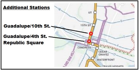
Republic Square station fills need

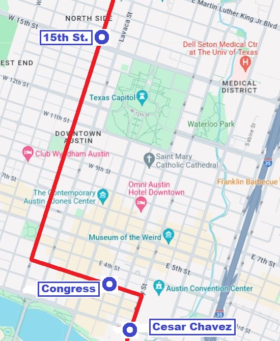
This gap can be filled by a Republic Square station (between W. 4th and 5th Streets), as shown in the graphic above (at the head of this article), which we’ve adapted from the DAA map. On our graphic, red lines radiating westward from the proposed station indicate approximate 4 to 5-minute walk distances to points in this area. Southwest downtown includes such major sites as the Federal Courthouse, the Seaholm development (with various shops and restaurants), the Austin Central Library, and several large condo and apartment highrises. The district also includes a multitude of other establishments, such as smaller shops, hotels, restaurants, and more. A Republic Square LRT station would also be just six blocks from the major westside Whole Foods Market.

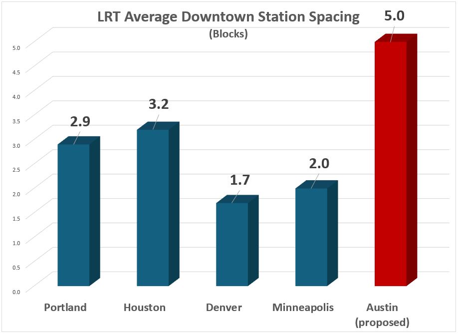
The need for another downtown station (in addition to stations already proposed by the Project Connect team and the DAA’s Wooldridge Square concept) is highlighted in the following graph comparison of station spacing.  This uses roughly equivalent block lengths in several peer cities (considered quite successful in the industry); the data used for Austin includes the proposed Wooldridge Square station, which Project Connect considers an “option”. This comparison suggests that the downtown station spacing so far proposed for Austin’s coming LRT system seems inconsistent with Best Practices by these typical peer systems.

Even with “optional” Wooldridge station, proposed spacing of Austin’s downtown LRT stops appears to violate Best Practices of several peer city systems. Graphic: ARN.

Easy Interface with current transit hub

In addition to ease of access, another factor typically involved in the layout and spacing of downtown stations is the need to minimize peak crowding and to avoid overcrowding at any station in these high-population areas. Providing too few stations in these situations (which may be indicated by longer stop-spacing) can create excessive crowding that is unpleasant, dangerous, and disruptive to smooth operation and service.

And in regard to the proposed Republic Square station specifically, there’s another major consideration: the opportunity for LRT to interface with the major bus transit hub at Republic Square, which has functioned for years to provide a relatively smooth interface among routes, well-known to the public.

In artistic simulation, a light rail train rolls through Republic Square – but without a station! Graphic: Austin Transit Partnership.

Not only is the Republic Square hub well-established and familiar to the transit-riding community, it’s positioned  six blocks (along 4th St.) from the downtown MetroRail station at the Austin Convention Center, providing a feasible interconnection between MetroRail and the large assortment of bus routes converging at Republic Square. Adding an LRT station here would expand Republic Square’s role into a multi-modal transit hub.

For multiple reasons, a Republic Square station would fill a critical need and eliminate the remaining serious gap in the proposed downtown LRT alignment. But if this gap were to remain in the final plan, we can’t help imagining whether future generations of Austinites will be wondering: “What were they thinking?” And it’s critical to keep in mind here that retrofitting an urban rail station into an existing alignment – particularly in an intensively developed central-city environment – is far more expensive than including it in the original construction project. ■

h1

Downtown Light Rail Plan Needs More Stations

18 December 2023
Simulation of LRT train on Guadalupe St. at Republic Square from Project Connect’s revised plan. But so far, the plan does not actually include a station at this crucial downtown transit hub! Source: ATP

By Lyndon Henry, Editor

Austin’s light rail transit (LRT) project continues to progress despite difficulties. The Austin Transit Partnership (ATP) and Project Connect (PC) planning team have so far been able to overcome serious legislative and litigational threats from public transport opponents. Equally important, they’ve managed to navigate through serious budget problems arising from design complications, external economic inflation, and other factors.

It’s a relief at last to have the workable (and hopefully entirely affordable) 3-branch light rail transit (LRT) system plan that ATP has adopted, shown in this map, publicly released this past May, which indicates proposed station locations as well as planned future line extensions:

ATP’s proposed Phase 1 surface LRT plan. Source: ATP

The revised downtown route is a surface alignment following several streets: Trinity St., 3rd St., and Guadalupe St. However, in discussions this past spring and summer with ATP staff and technical advisory committee members, I called attention to a major concern with respect to the small number of stations – just three – to serve both Downtown and the Capitol Complex – i.e., two-thirds of Austin’s critically important Central Area. All three proposed station locations – Cesar Chavez, Congress, and 15th St. – can be seen on this closeup from the map:

Closeup of LRT map with proposed downtown stations (Cesar Chavez, Congress, 15th St,)

This deficit in stations results in a serious problem of inadequate station spacing in this key activity center complex. In particular, there is a 14-block gap (in line length) between the proposed Congress station (located on 3rd St. west of Congress Ave.) and the proposed 15th St. station (on Guadalupe). The route distance (per Google Maps) for this gap between these two stations measures 5,633 feet. That’s 1.1 mile, or 1,717 meters, between these stations.

The following more detailed map graphic, created from Google Maps, facilitates a more accurate assessment of the proposed LRT route and stations within the grid of streets, blocks, and major landmarks, and a better visual sense of the lack of stations along Guadalupe St., resulting in the sizable gap between the proposed Congress and 15th St. stations.

ATP’s proposed downtown LRT route and stations. Source: LH, via Google Maps

This is an exceptionally long spacing between stations for a major dense central area, and it appears to be inconsistent with Best Practices as exhibited by downtown route configurations in peer cities, particularly with central-city surface alignments, such those in as Portland, San Diego, Sacramento, Phoenix, Minneapolis, Dallas, Houston, Denver, Salt Lake City, and others, where spacing typically ranges from 3 to 8 blocks. In fact, I can’t immediately think of any other light rail system in North America with a station spacing that wide in the heart of its downtown.

Transportation consultant Jarrett Walker has discussed the stop-spacing issue on his website, HumanTransit.org: Basics: The Spacing of Stops and Stations.  As Walker notes, “… transit planners generally observe that the walking distance that most people seem to tolerate — the one beyond which ridership falls off drastically —  is about 400m (around 1/4 mi) for a local-stop service, and about 1000m (around 3/5 mi) for a very fast, frequent, and reliable rapid transit service.”

Here, Walker is discussing stop-spacing for a city as a whole. However, it’s crucial to consider the particular factors in play regarding the spacing of stations and adequate access in a downtown or other densely concentrated high-activity area. Given the dense mesh of downtown street structure, a circular radius yardstick doesn’t seem adequately applicable – transit users can’t walk in straight-line radii between worksites and transit stations, they must follow the zig-zag street configuration, which significantly increases total access distance. Plus additional time spent waiting at traffic lights must be taken into account.

Real access time in minutes would probably be a better comparative measure of ease of access. And it’s not just a matter of convenience. This means that excessively wide station spacing in a downtown may impair access, discourage use of the transit service, and thus significantly reduce ridership. It also imposes extra difficulty for the elderly and mobility-challenged. Potentially the problem could also damage public goodwill.

While the Project Connect team has expressed concern about steep gradients on Guadalupe at 5th St. and several blocks north that affect station construction, I note that industry guidelines are not rigid but do allow design to follow existing street gradients where this can be done consistently with safety and Best Practices. (Reference: TCRP Report 155, 2nd Ed. 201; U.S. Access Board, Accessibility Standards.)

Taking into account these considerations, to remedy this (so far publicly presented) 1.1-mile gap in downtown LRT station spacing, on 28 April I proposed that at least two additional downtown stations on Guadalupe St. be added to ATP’s revised surface LRT plan. As illustrated in the small amended map segment presented below, these include a station at 4th/Guadalupe to serve the existing transit hub at Republic Square and the lower west side of downtown, as well as a station at 10th/Guadalupe, intended to improve accessibility to the north end and upper west side of downtown, including the Travis County Courthouse, many legal and professional offices, and the Austin History Center.

Proposed additional downtown stations. Source: LH

ATP personnel indicated that they were considering these proposals, and the broader possibility of adding more downtown stations to the revised LRT plan. So far, no changes have been publicized. ■