
Why light rail transit is crucial for the Orange Line corridor
28 June 2019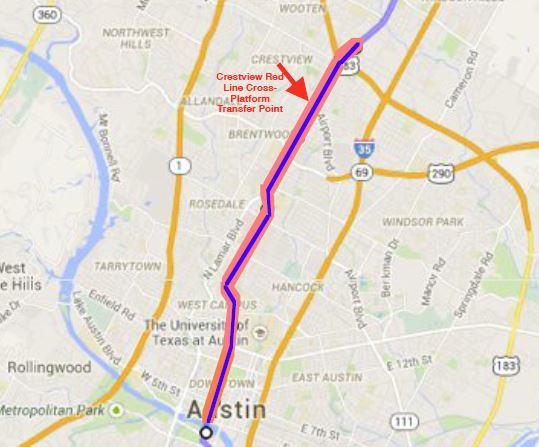
A logical and affordable first step to actually implement a bona fide “high-capacity transit” system in the Orange Line corridor would be a 6.2-mile LRT starter line from US183 to downtown. Map: David Dobbs.
♦
Commentary by David Dobbs
This commentary has been adapted, edited, and slightly expanded from original comments submitted to the Federal Transit Administration in response to Early Scoping for Project Connect’s Orange Line “high capacity” corridor (North Lamar-Guadalupe-downtown). David Dobbs is Executive Director of the Texas Association for Public Transportation and publisher of LightRailNow.org.
Austin, Texas is a line village whose principle population centers are caught between two major north-south freeways that are rapidly approaching maximum capacity and cannot be meaningfully expanded. The Texas Transportation Institute (TTI) states that failure to adequately address Austin’s future mobility in the IH-35 corridor will essentially shut down economic growth by 2035. [1] This approximately 21-mile-long, one-to-three-mile-wide ribbon of urban population has only one continuous north-south travel corridor that can provide sufficient mobility for future residents – and then only if a well-designed electric urban light rail transit (LRT) line is constructed as a surrogate/alternate to IH-35 from Parmer Lane to Slaughter Lane, primarily routed via North Lamar, Guadalupe, and South Congress
This concept – basically, an elaboration of the Orange Line sketched in Project Connect’s Long-Term Vision Plan – is summarized in the linked 5-doc_Dobbs_Objective-2030-Basic-Concept page (PDF). Constructed as surface-running LRT (e.g. Phoenix, Houston, etc.), revenue service could begin in 2030. With a 17 mph average speed, a cross-platform transfer point with the Red Line at the Crestview Station, and major park & ride facilities at each end, such a line could plausibly carry as many as 100,000 daily rider-trips by 2035. Running through the densest sectors of the city, it would serve as a template for dense, mixed-use transit-oriented development (TOD), while at the same time providing excellent access to outlying areas sans the use of automobiles. We estimate the cost of this 21-mile Orange Line at approximately $2 billion in 2019 dollars, a fraction of the cost of expanding IH-35 (see map below).
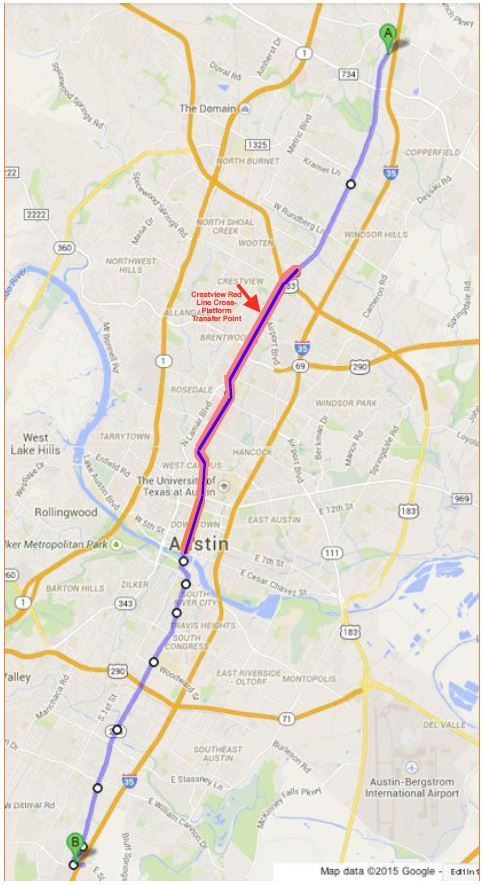
LRT in Orange Line corridor could link Tech Ridge on the north end to Southpark Meadows on the south. Map: David Dobbs.
As the Objective 2030 Basic Concept page also suggests, a first step toward this 21-mile central route could be a much shorter initial starter line (at substantially more modest cost). Illustrated in red on the map (and in the map excerpt included at the top of this post) is a 6.2-mile Minimum Operable Segment running from the North Lamar Transit Center (at US183) on the north end, south via N. Lamar and Guadalupe (and Lavaca) to a south terminus at W. 4th St. downtown.
The Austin community has spent more than $30 million in planning money over the last 40 years trying to get this essential transportation element built here in the Texas capital – see, for example, FTA’s summary of the 2000 LRT plan. [2] Unfortunately, with mobility worsening and the pace of critical urban decisions speeding up, time is running out. We simply cannot wait for some hypothetical new technology to be developed and become available at some undetermined date in the future. Light rail is the proven alternative world-wide.
■
References
[1] Mobility Investment Priorities Project Long-Term Central Texas IH 35 Improvement Scenarios August 2013 pp 58-61
http://tti.tamu.edu/documents/TTI-2013-18.pdf
[2[ FTA New Starts/Small Starts Austin, Texas/Light Rail Corridors (November 1999-& 2000)
https://austinrailnow.com/wp-content/uploads/2014/05/fta_austin-texas-cmta-light-rail-corridors-new-starts-nov-1999_.pdf
■


Leave a comment