Archive for the ‘Urban Rail’ Category

h1

Project Connect gets it wrong — Urban rail starter lines are much cheaper than extensions

14 August 2014
LEFT: Denver's starter LRT line, a 5.3-mile line opened in 1994, was routed and designed as a simple, surface-routed project to minimize construction time and cost. All-surface alignment avoided heavy, expensive civil works and kept design as simple as possible. Photo: Peter Ehrlich. RIGHT: Subsequent extensions, such as this West line opened in 2013, have required bridges, grade separations, and other major civil works, resulting in a unit cost 61% higher than that of the starter line. Photo: WUNC.org.

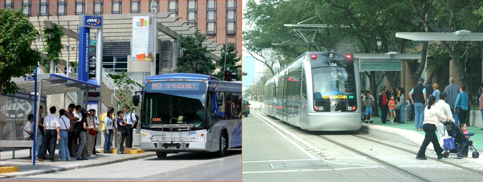
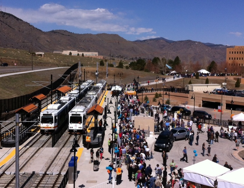
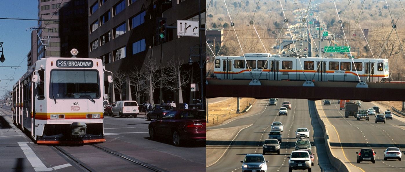
LEFT: Denver’s starter LRT line, a 5.3-mile line opened in 1994, was routed and designed as a simple, surface-routed project to minimize construction time and cost. All-surface alignment avoided heavy, expensive civil works and kept design as simple as possible. Photo: Peter Ehrlich. RIGHT: Subsequent extensions, such as this West line opened in 2013, have required bridges, grade separations, and other major civil works, resulting in a unit cost 61% higher than that of the starter line. Photo: WUNC.org.

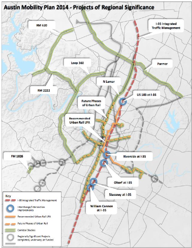
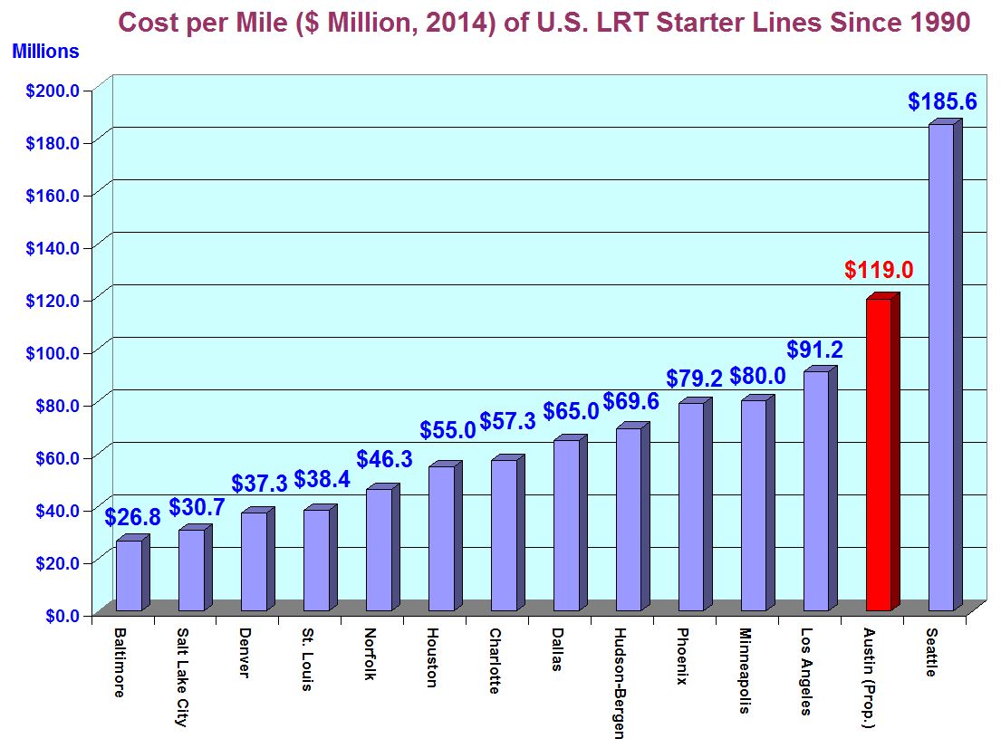
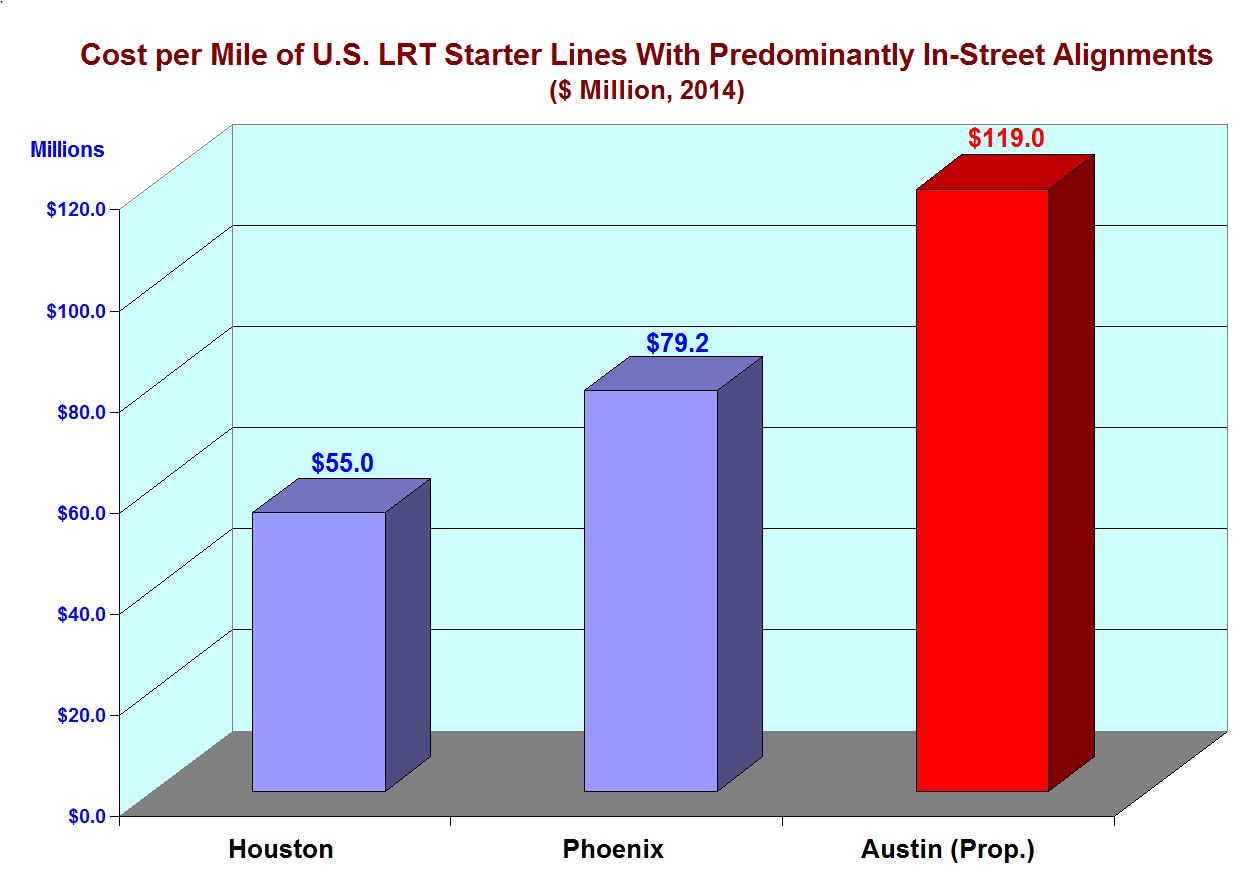
Since Project Connect released the cost estimates for their proposed 9.5-mile Highland-Riverside urban rail starter line last spring, agency representatives have tried to argue that the line’s projected cost of $144.8 per mile (2020 dollars) is comparable to that of other recent light rail transit (LRT) projects, citing new extensions in Houston, Portland, and Minneapolis.

Project Connect's chart comparing their proposed Highland-Riverside "Austin Urban Rail" starter line cost to costs of extensions of several other mature light rail transit systems.

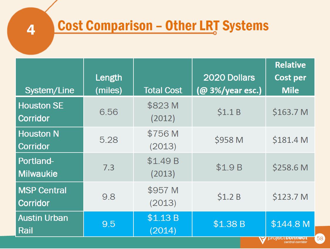
Project Connect’s chart comparing their proposed Highland-Riverside “Austin Urban Rail” starter line cost to costs of extensions of several other mature light rail transit systems. (Click to enlarge.)

Austin Rail Now challenged this comparison In our recent analysis, Project Connect’s Austin urban rail would be 3rd-most-pricey LRT starter line in U.S. history. We argued that comparing the high cost of extensions of other, mature systems, was invalid, because urban rail starter lines tend to be much lower in cost than subsequent extension projects.

That’s because, in designing a starter line — the first line of a brand-new system for a city — the usual practice is to maximize ridership while minimizing costs through avoiding more difficult design and construction challenges, often deferring these other corridors for later extensions. In this way, the new system can demonstrate sufficient ridership and other measures of performance sufficient to convince both local officials and the public that it’s a success from the standpoint of being a worthwhile investment.

In contrast with starter lines, where officials and planners usually strive to keep design minimal and hold costs down in order to get an initial system up and running with the least demand on resources (and public tolerance), extension projects more often are deferred to later opportunities, mainly because they frequently contend with “the much more difficult urban and terrain conditions that are typically avoided and deferred in the process of selecting routes for original starter systems.” Deferring more difficult and expensive alignments till later also allows time for public acceptance, and even enthusiasm, for the new rail transit system to take root and grow.

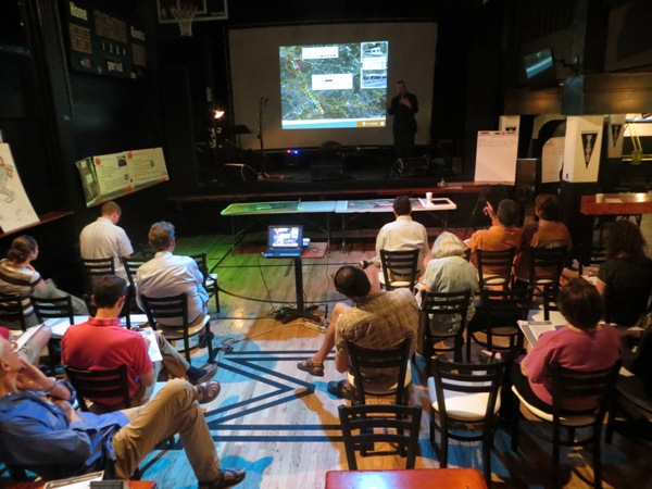
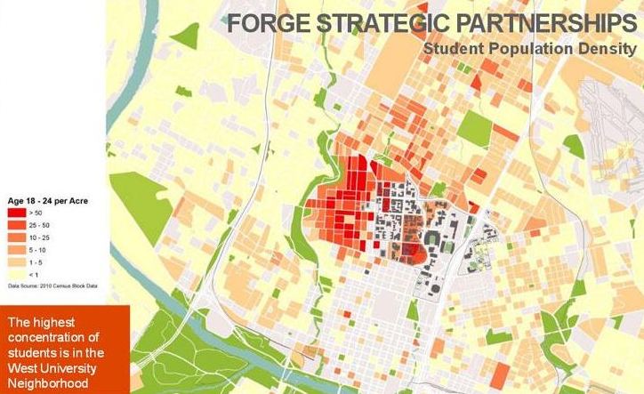
Austin’s case provides an illustration. As our article, Austin’s 2000 light rail plan — Key documents detail costs, ridership of Lamar-Guadalupe-SoCo route, describes, Capital Metro’s original 2000 LRT plan envisioned a “Phase 1” 20-mile system consisting of a 14.6-mile line from McNeil to downtown, plus a short branch to East Austin and a longer extension down South Congress to Ben White Blvd. In Year of Expenditure (YOE) 2010 dollars, that full system was projected to cost $1,085.8 million (about $1,198 million in today’s dollars). But a billion-dollar project was deemed too hefty a bite for the city’s first foray into rail, so decisionmakers and planners designated the shorter 14.6-mile northern section as a Minimum Operable Segment (MOS), with a more affordable (and, hopefully, more politically palatable)pricetag of $739.0 million in 2007 YOE dollars (roughly $878 million in current dollars).

After an initial starter line is established, for most subsequent extension projects the unit cost — per mile — tends to increase because, as previously indicated, officials and designers are willing to tackle more daunting corridors and alignments. Denver is a useful example.

In 1994 Denver established basic LRT service with a comparatively simple 5.3-mile starter line, running entirely on the surface in both dedicated street lanes and an available, abandoned center-city railway alignment, with an installation cost of $37.3 million per mile (2014 dollars). From that beginning, the system has been gradually expanded with increasingly more ambitious and more costly extensions. In 2013, Denver opened its West Line (the W line) to Golden; constructed over much more daunting terrain and obstacles, with multiple grade separations, bridges, and long elevated sections, plus more complex signal and communications systems and more elaborate station facilities. The West line was finished at a cost in 2014 dollars of about $59.9 million per mile — a unit cost about 61% higher than that of the original starter line.

Despite such evidence, at an Aug. 5th urban rail forum sponsored by the Highland Neighborhood Association, Project Connect’s Urban Rail Lead, Kyle Keahey, dismissed the assertion that starter lines were lower in cost per mile than extensions. Instead, he insisted, “the reverse is true.”

Really? But this claim is refuted even by the same cases that Project Connect has presented as peer projects for comparing the estimated $144.8-million-per-mile cost (2020) of its Highland-Riverside proposal.

In the following comparative analysis, we use Project Connect’s own year-2020 cost-per-mile figures for their selected “peer” projects. For each of those we use the starter line cost-per-mile data from our earlier May 8th article (cited above), plus data for Portland’s original starter line (a 15.1-mile line opened in 1986 from central Portland to the suburb of Gresham). These unit costs, in 2014 dollars, were then escalated to year-2020 values via the 3% annual factor specified by Project connect for their own table data.

The resulting comparison is shown below:

Using Project Connect's selected LRT systems, this comparison shows that the cost per mile of new starter lines tends to be significantly less than the cost of later extensions. Graph: ARN.

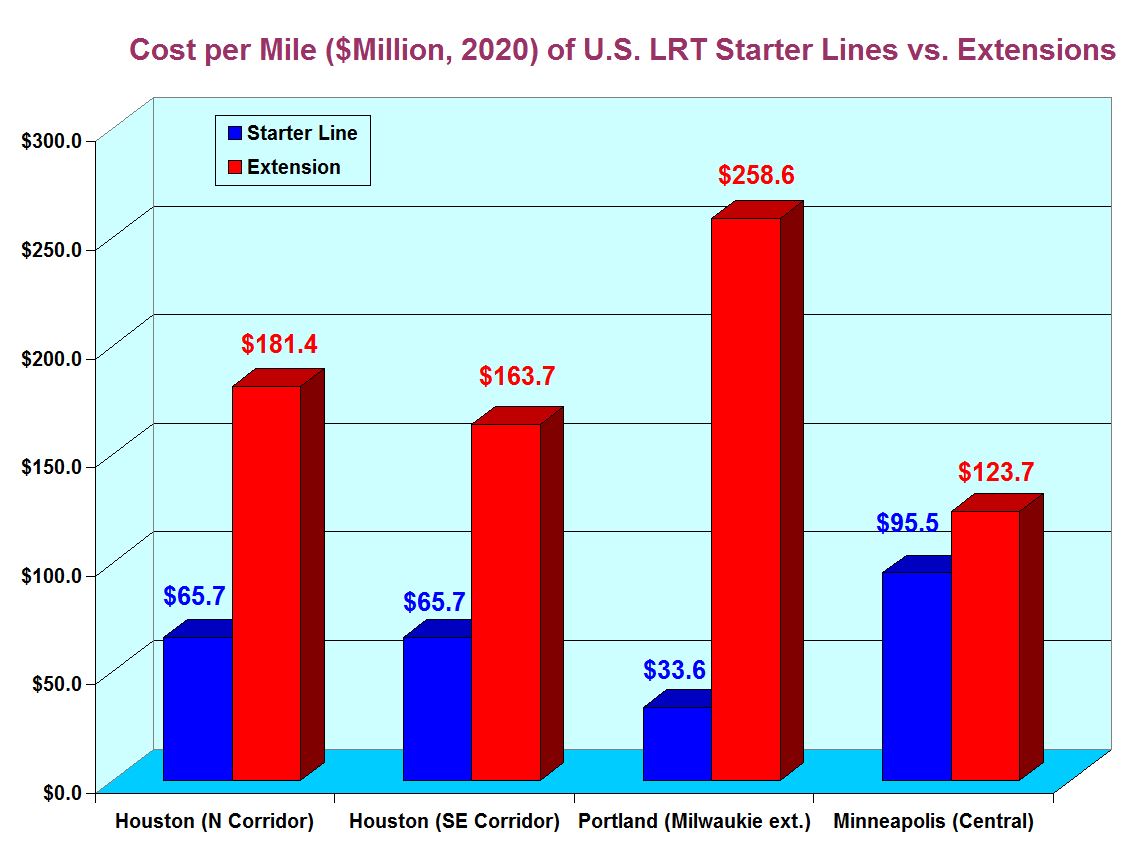
Using Project Connect’s selected LRT systems, this comparison shows that the cost per mile of new starter lines tends to be significantly less than the cost of later extensions. Graph: ARN. (Click to enlarge.)

Clearly, this analysis corroborates our original assertion — based on these cases, the unit costs of LRT starter lines tend to be considerably lower than the unit cost of later extensions when these have developed into more mature systems. And, at $144.8 million per mile, the unit cost of Project Connect’s proposed 9.5-mile Highland-Riverside urban rail starter line is certainly far higher than the cost of any of the original starter lines of these selected systems — all using Project Connect’s own cases and criteria.

Q.E.D., perhaps? ■

h1

Official urban rail plan bulldozed to ballot — in bulging bundle

11 August 2014
City Council's Aug. 7th urban rail ballot measure was included in massive bundle with other disparate items. Graphic: Glogster.com.

City Council’s Aug. 7th urban rail ballot measure was included in massive bundle with other disparate items. Graphic: Glogster.com.

With about as much suspense and excitement as, well, making sausage, the Austin City Council this past Thursday, Aug. 7th, finally rammed through the official (and seriously flawed) Highland-Riverside urban rail plan to the next big step — a ballot item placed up for voters’ approval (or rejection) this coming Nov. 4th.

While Austin transportation officials and some Project Connect representatives have tried to radiate a public image of “openness”, “transparency”, “fairness”, sweetness, and cooperation in their pursuit of their urban rail agenda, the machinations, subterfuges, and intrigues involved with this Council vote expose a more troubling reality. This consistently ruthless, damn-the-torpedoes, bulldoze-the-opposition functional style for well over a year has dismayed, outraged, disgusted, and angered a wide swath of the Austin community who have consistently felt shut out of bona fide participation in the public transportation planning process. (See, for example: City Council to Austin community: Shut Up; Will Project Connect continue to gag the public?; City Council to Central Austin: Drop Dead; Meetings, “open houses”, workshops … and democratic process.)

Another move to gag public criticism

The Council’s Aug. 7th vote shenanigans seemed to draw from this same playbook. Perhaps the most salient indication of this is the City administration’s bundling of the urban rail bond measure in a single ordinance with the totally unrelated authorization of the vote for the new “10-1” Council. Item #17 on the council’s Aug. 7th agenda proposed to

Approve an ordinance ordering a general municipal election to be held in the City of Austin on November 4, 2014, for the purpose of electing a Mayor (at large) and City Council Members (single member districts) for District 1, District 2, District 3, District 4, District 5, District 6, District 7, District 8, District 9, and District 10; ordering a special election for the purpose of authorizing the issuance of general obligation bonds; providing for the conduct of the election; authorizing the City Clerk to enter into joint election agreements with other local political subdivisions as may be necessary for the orderly conduct of the election; and declaring an emergency.

By packaging all this — in effect, the basic election of the new Council itself — in a single “kitchen sink” ordinance, the smooth operators of the current administration thus set up the ordinance so that if a current councilmember would vote against the urban rail/transportation proposals (highly unlikely in any case, given all the strong-arming behind the scenes), he/she would also be voting against calling the election for the new council. Most likely, the real intent of this maneuver was probably to place community opponents of the urban rail bond plan in the awkward position of calling for a No vote to the election of the new council if they called for a No vote against putting the bonds on the ballot. Thus, the tactic seemed yet another method of suppressing criticism and opposition. Machiavelli would surely be proud.

But the urban rail ballot ordinance wasn’t just “bulging” with the entire new Council vote authorization thrown into the package. The Aug. 7th ordinance also includes authorization for Capital Metro — the sales tax-supported transit authority — to allocate its own funds to an urban rail project with lots of amorphous pieces and blurry edges:

As contemplated by the Locally Preferred Alternative contained in the 2014 Strategic Mobility Plan approved by Council on June 26, 2014, the fixed rail transit system is expected to consist of a 9.5 mile urban rail double-tracked, electrified route in mostly dedicated guideways. The general location of the proposed route of the fixed rail transit system is expected to run along a route that will serve the East Riverside Corridor, downtown Austin, the State Capitol complex, the Medical School complex, the University of Texas, Hancock Center, Austin Community College Highland campus, and surrounding neighborhoods. The general description of the form of the fixed rail transit system, including the general location of the proposed route, is provided herein pursuant to Section 451.071, Texas Transportation Code, to authorize Capital Metropolitan Transportation Authority to participate and to spend its funds in building, operating and maintaining the fixed rail transit system. The final alignment of the route may be adjusted to accommodate any required governmental approvals and to maximize service characteristics, including stop spacing, speed, frequency, and reliability. Capital Metropolitan Transportation Authority shall participate in building, operating and maintaining the fixed rail transit system to the extent and pursuant to such terms and conditions as shall be mutually acceptable to the City and Capital Metropolitan Transportation Authority.

Road projects potentially dwarf rail

However, the really huge, disjointed component of this ballot package has been the focus of leaks, news reports, and small dollops of information for weeks. As is now widely known, a hefty assortment of major roadway projects were included in a cumbersome, disparate hodgepodge hastily contrived and christened the “2014 Strategic Mobility Plan”.

According to leaks and hints in news reports, bundling hundreds of millions of dollars’ worth of road projects with the rail proposal had been demanded by major pro-highway business interests as a condition for their support and the contribution of a million dollars to the prospective war chest for Project Connect’s ballot initiative campaign. The result was the “2014 Strategic Mobility Plan” (SMP), reportedly designed to appease the prevailing leadership of groups such the Greater Austin Chamber of Commerce and Real Estate Council of Austin with $400 million of politically selected road project sweeteners.


Council's ballot measure makes urban rail funding contingent on road construction projects potentially more expensive than rail. Photo: Robert Miller, via TexasFreeway.com.

Council’s ballot measure makes urban rail funding contingent on road construction projects potentially more expensive than rail. Photo: Robert Miller, via TexasFreeway.com.


Another “sweetening” factor: Federal funding match for road projects is typically far higher than for transit; for Interstate highway system projects, the nominal Federal Highway Administration (FHWA) match is 90%. Thus, the $240 million of I-35 projects listed in the SMP could well facilitate projects of $2.4 billion in actual magnitude. And the other federal-system road projects in the SMP could also receive outsized FHWA matching grants. Plus contributions by the Texas Department of Transportation (TxDOT).

In contrast, the rail project is expected, at best, to qualify for just 50% Federal Transit Administration match, implying a maximum project of about $1.2 billion. Thus, under the “green” facade of “urban rail”, the SMP package is a rubber-and-asphalt-oriented concoction in which the potential highway projects grotesquely dwarf the rail component.


City's "2014 Strategic Mobility Plan" is packed with road projects that must be funded before urban rail bonds can be issued. Potential cost dwarfs cost of rail. ("Future Phases of Urban Rail" dashed lines on map are likely just sucker bait to lure support from gullible voters; fine print specifies merely "high-capacity transit" which could mean "bus rapid transit", term used to describe MetroRapid bus service.) Map: Screenshot from SMP.

City’s “2014 Strategic Mobility Plan” is packed with road projects that must be funded before urban rail bonds can be issued. Potential cost (including federal and state match) dwarfs cost of rail. (“Future Phases of Urban Rail” dashed lines on map are likely just sucker bait to lure support from gullible voters; fine print specifies merely “high-capacity transit” which could mean “bus rapid transit”, term used to describe MetroRapid bus service.) Map: Screenshot from SMP. (Click to enlarge.)


As City of Austin officials endeavored to craft the ballot language for the “roads + rail” bond package, they at first envisioned a combined $1 billion package ($600 million rail + $400 million roads). However, they hit a snag: Texas law forbids the bundling of such bonds. To avoid a deal-killer with the pro-road interests, a peculiar work-around was conceived — zap the bond proposal for the roads component, but make the rail bonds contingent on “providing” $400 million of unspecified road works funding! We’re not kidding!

At first most news media reporters and journalists were fooled, reporting the Council’s Aug. 7th ordinance as placing “a one-billion-dollar bond package” on the ballot. But their stories were quickly revised to report a $600 million rail bond package, plus the cumbersome, contingent road funding component, as they read the actual ballot language more closely:

The issuance of $600,000,000 bonds and notes for rail systems, facilities and infrastructure, including a fixed rail transit system to be operated by Capital Metropolitan Transportation Authority (which may spend its funds to build, operate and maintain such system) servicing the East Riverside Corridor, downtown Austin, the State Capitol complex, the Medical School complex, the University of Texas, Hancock Center, Austin Community College Highland campus, and surrounding neighborhoods, and roadway improvements related to such rail systems, facilities, and infrastructure; provided that the City may not issue bonds or notes to pay costs of the fixed rail transit system (other than expenditures for planning, designing and engineering) unless (i) the City obtains grant or match funding for the cost of the fixed rail transit system from the Federal Transit Administration or one or more other federal or state sources and (ii) the City provides funding in an amount not less than $400,000,000 to pay costs of roadway improvement projects of regional significance that are designed to relieve congestion, enhance mobility and manage traffic in the I-35, US 183, SH 71, RM 620, RM 1826, RM 2222, FM 734 (Parmer), Lamar Boulevard, and Loop 360 corridors; and the levy of a tax sufficient to pay for the bonds and notes.

More debt, but without public vote?

So where might this mysterious $400 million in road funding come from? Unless the City has a hidden cache of $400 million tucked away somewhere, almost surely this would require some form of debt financing. One option could be to place another bond measure on a future ballot asking voters to approve $400 million in additional City debt for these road projects.

However, as Austin community transportation activist and researcher Roger Baker has pointed out, other debt financing options are available that don’t require public votes, as do bonds. For example, there are Certificates of Obligation (COs), Anticipation Notes, and Time Warrants. Useful descriptions of such public funding alternatives can be found online in a “Public Finance Handbook” published by the Texas Association of Counties and a “Public Finance Issues” guide posted by Thomas M. Pollan with Austin-based Bickerstaff Heath Delgado Acosta LLP.

Of these alternatives, COs may be the leading choice for City of Austin and Project Connect leaders in their quest for a $400 million road project funding solution that avoids a risky and awkward public vote. As the Handbook cited above relates, “Unlike G.O. Bonds that always require an election, the CO’s do not require an election unless at least 5% of the registered voters in the county submit a valid petition protesting the issuance.” (Emphasis added.)

Often, the public entity may desire to sell the COs for cash “in order to have funds to pay contractors, equipment suppliers, and costs of issuance.” But there’s a catch — “The list for which CO’s may be sold for cash with only a tax pledge is limited…”, including fairly extraordinary situations such as “it is necessary to preserve or protect the public health of the residents” of the district holding the COs. (Emphasis added.)

Well, whaddaya know — lo and behold, the Austin City Council’s humongous hodgepodge ordinance, authorizing the new Council election, the urban rail bond election, and the kitchen sink, just happens to contain a Part 13 that — hold on to your chair — stipulates the following:

The Council finds that the need to immediately begin required preparations for this election constitutes an emergency. Because of this emergency, this ordinance takes effect immediately on its passage for the immediate preservation of the public peace, health, and safety. [Emphasis added.]

Hefty property tax rate increase

So how much would all this debt to preserve our “peace, health, and safety” cost us? Part 7 of the ordinance itself details the bad news:

As reported in the 2014 Strategic Mobility Plan, applying the assumptions used in the General Obligation Bond Capacity Analysis dated April 29, 2014, which includes forecasted growth in taxable assessed values, City financial staff has determined that, if the bonds and notes are issued, the City’s total tax rate would increase by $0.0625 per $100 of taxable assessed valuation (as compared to the City’s total tax rate as of the date of adoption of this ordinance) …

Even for fairly lower-middle-income and low-income homeowners, that implies an annual property tax bill increase of at least over $100. For average-income and homeowners and those at higher levels, it almost surely means an additional tax bite of at least several hundred dollars — an additional body-blow to taxpayers already seriously financially stressed with steep home valuation hikes, other prospective property tax increases, and hikes in electric and water service rates. Meanwhile, local officials continue to dispense seemingly endless giveaways from the public treasury to corporate interests (in exchange for dubious and largely undefined and untracked benefits).


Austin homeowners and other residents are steadily burdened with higher taxes and utility rates, with the rationale of vague "projections" of local "new jobs" and other benefits whose validity is never reliably tracked. Are massive subsidies to real estate developers, projects like the F1 racetrack, UT's East Campus expansion plans, the Medical Center development, a largely "showpiece" urban rail line, and other ventures worth this sacrifice?

Austin homeowners and other residents are steadily burdened with higher taxes and utility rates, with the rationale of vague “projections” of local “new jobs” and other benefits whose validity is never reliably tracked. Are massive subsidies to real estate developers, projects like the F1 racetrack, UT’s East Campus expansion plans, the Medical Center development, a largely “showpiece” urban rail line, and other ventures worth this sacrifice? Graphic: Active Rain website.


If what’s proposed were a worthwhile new urban rail line, cautiously implemented and cost-effective, that actually addressed true mobility problems, would local voters consider that a beneficial project worth paying for? Maybe.

But it may be hard for many voters to perceive any way the Highland-Riverside alignment proposed by the City of Austin on November’s forthcoming ballot solves, or even addresses, any real mobility needs or congestion problems. Particularly since it misses the city’s densest, most heavily traveled central corridor (Guadalupe-Lamar), with its string of major activity and employment centers plus the West Campus.

So, Austin voters need to ask themselves: Is this proposed line useful enough, and beneficial enough, to justify the cost to us? Are the land development goals of local real estate interests, and the East Campus expansion aims of the University of Texas, worthy of this much taxpayer subsidy?

The answer to those questions will come on November 4th. ■

h1

Three “incontrovertible facts” about urban rail proposals in Austin

2 August 2014
ACC's map from its own website (annotated by Austin Rail Now) shows ACC campus (marked with inverted blue "teardrop" with MetroRail's Highland station at its northwest corner.

ACC’s map from its own website (annotated by Austin Rail Now) shows ACC campus (marked with inverted blue “teardrop”) with MetroRail’s Highland station at its northwest corner.

By Andrew Clements

The following commentary has been slightly adapted from an original Letter to the Editor published July 21st by the Austin Chronicle.

On June 26th, the City Council endorsed Project Connect’s urban rail line route. Public testimony was limited, but I would have pointed out three incontrovertible facts.

(1) The first is that the approved route terminates at the old Highland Mall, with no plans to extend any further. Every initial line, as part of any transit system, should have plans to be extended, but this one isn’t. Terminating Austin’s initial urban rail line there is proven illogical by no plans to extend it.

(2) And doubly illogical because, second, the entire proposed redevelopment is already served by passenger rail. As shown in ACC’s own map at the top of this post (with annotations by ARN), the Highland station on the MetroRail Red Line is within a half-mile of the entire Highland Mall site – the distance passengers are willing to walk in a transit trip.

Spending hundreds of millions of dollars on a tunnel, and placing new rail on Airport Boulevard (paralleling, only a few feet away, the already existing Red Line passenger rail) to reach a planned redevelopment already served by voter-approved (and funded) passenger rail is a very expensive double service.


Closeup of Highland ACC segment of Project Connect's proposed urban rail map shows how the proposed urban rail line (orange) would effectively duplicate the existing MetroRail Red Line paralleling Airport Blvd. (MetroRail drawn as red line, with Highland station shown as red dot near top of map). Project Connect line would terminate at ACC administration building on far east side of campus, with no plans for extension, and no available corridor for extension. Map: Screenshot by ARN, from Project Connect map.

Closeup of Highland ACC segment of Project Connect’s proposed urban rail map shows how the proposed urban rail line (orange) would effectively duplicate the existing MetroRail Red Line paralleling Airport Blvd. (MetroRail drawn as red line, with Highland station shown as red dot near top of map). Project Connect line would terminate at ACC administration building on far east side of campus, with no plans for extension, and no available corridor for extension. Map: Screenshot by ARN, from Project Connect map.


(3) Third, the projected ridership for the Guadalupe/North Lamar light rail route, considered by voters in 2000, was twice what is proposed now. Higher ridership indicates overall success of a rail line, which means federal funding is more likely, with a likelihood of more voter support of the next urban rail line. Guadalupe and North Lamar is where millions of dollars were spent, in 1999-2000, in an already approved federal study determining where rail should be.


Screenshot from Federal Transit Administration's New Start summary table of Capital Metro's 2000 urban rail (light rail transit) plan. Projected daily ridership (circled in red) of 37,400 is more than double the 18,000 Project Connect claims for its current Highland-Riverside proposal — and more than triple a more realistic figure of 12,000. Annotation: ARN.

Screenshot from Federal Transit Administration’s New Start summary table of Capital Metro’s 2000 Guadalupe-Lamar urban rail (light rail transit) plan. Projected daily ridership (circled in red) of 37,400 is more than double the 18,000 Project Connect claims for its current Highland-Riverside proposal — and more than triple a more realistic figure of 12,000. Annotation: ARN.


Mayor Leffingwell has coined the phrase “rail or fail”. A November referendum will likely fail, because the mayor has unfortunately led a special-interest-dominated effort that has not considered neighborhood and rail advocate voices, but instead a process where the data has been manipulated to a point where the result is anything but objective. Rail advocates like me hope that following a likely November referendum failure, we can immediately begin planning, and achieving, rail on Guadalupe/North Lamar. ■

h1

Why Project Connect’s “Highland” urban rail would do nothing for I-35 congestion

9 July 2014
I-35 is the most congested roadway in Texas. But is this really the main travel corridor for commuters from "Highland-Riverside" neighborhoods to the Core Area? And would Project Connect's proposed urban rail line have any perceptible impact? Photo source: KVUE-TV.

I-35 is the most congested roadway in Texas. But is this really the main travel corridor for commuters from “Highland-Riverside” neighborhoods to the Core Area? And would Project Connect’s proposed urban rail line have any perceptible impact? Photo source: KVUE-TV.

By Dave Dobbs and Lyndon Henry

Lately, Project Connect representatives have been trying to claim that their meandering urban rail route proposed from Highland, through Red River and San Jacinto, to East Riverside, somehow addresses the problem of congestion on … I-35.

Really?

Leaving I-35 at the Highland site to ride a slow train to downtown doesn’t make any sense when, at Highland ACC, you are almost at the Core Area. By the time you leave the freeway, park your car, walk to the station, wait for the train, and ride downtown, you might as well have stayed on the freeway.

The I-35 traffic jam actually begins way north of Highland — at the confluence of Howard Lane, North Lamar, and I-35 — and that’s where people would park and ride a train if it were there. But first we have to build urban rail in the right place — up Guadalupe and North Lamar.

You have to put your transit station, with park & ride (P&R) access, near the outer end of the traffic jam. You don’t have to be a transportation savant to figure this out.

After all, as the public transit planning profession knows very well, P&R facilities need to be provided well upstream of the heavy congestion on a highway facility. There’s very little hope of attracting travelers off the highway if they already have to travel through severe congestion to access the transit station.

Project Connect’s claim of “congestion relief” is especially implausible when you further consider that they’re expecting prospective urban rail passengers to slog their way through the I-35 congestion, then, just a few minutes from their destination, to exit the freeway, hassle with parking, wait for a train, and then take a long, slow, sinuous train ride into the Core Area — a route that includes entering Airport Blvd., navigating through mixed traffic on Red River St., then winding through San Jacinto Blvd. and other streets comprising this tortuous “Highland” route.

What about the the hints from Project Connect that I-35 may be a major artery that neighborhood commuters themselves, along the proposed “Highland” rail route, supposedly use to reach the Core Area? To believe this speculation, you’d have to accept a vision of about 260 commuters per peak hour from these neighborhoods, currently driving, on average, about 6 blocks to then pack themselves onto a severely congested I-35 (#1 on TxDOT’s list of the state’s most congested roads) to then travel an average 28 blocks into the Core. And doing this when they have at least four other important but much less congested local arterials, including Guadalupe-Lamar, to use instead.

Commuters on I-35 would need to drive through miles of heavy congestion to reach Project Connect's proposed urban rail P&R at Highland ACC  — thus, little potential for "congestion relief". In contrast, Capital Metro's Tech Ridge P&R is located upstream of I-35 congestion. Alternative Guadalupe-Lamar urban rail plan would have North Lamar Transit Center P&R at US 183, upstream of congestion. Future urban rail extension up North Lamar to Howard Lane could provide another P&R upstream of I-35 congestion. Infographic map by ARN based on Google Maps.

Commuters on I-35 would need to drive through miles of heavy congestion to reach Project Connect’s proposed urban rail P&R at Highland ACC — thus, little potential for “congestion relief”. In contrast, Capital Metro’s Tech Ridge P&R is located upstream of I-35 congestion. Alternative Guadalupe-Lamar urban rail plan would have North Lamar Transit Center P&R at US 183, upstream of congestion. Future urban rail extension up North Lamar to Howard Lane could provide another P&R upstream of I-35 congestion. Infographic map by ARN based on Google Maps. (Click to enlarge.)

Maybe, but this is a scenario that similarly invites powerful skepticism. And is it worth over a billion dollars for an urban rail alignment that would lure perhaps about 65 motorists off I-35 in a peak hour (assuming about 25% modal split for Project Connect’s urban rail)?

Instead, as an authentic urban rail alternative to either I-35 or MoPac into the Core Area, you have to travel through the actual heart of the central city and its core neighborhoods on an actual travel corridor where you actually travel to and get off close to your destination. And a lot more of those destinations are within walking distance of Guadalupe-Lamar. That’s why there are 23,000 bus riders daily in this corridor today.

Some transit planner a quarter century ago put it something like this at an Austin public meeting: “All transit studies show that people will climb high mountains and/or swim deep rivers to access good rail service if it’s far enough out and is easily accessible by another mode (i.e., beyond the traffic jam), providing that their final destinations are within a quarter mile of a stop.”

The MetroRail Red Line demonstrates this wisdom; after Howard Lane, for passengers riding inbound AM peak trains, it’s standing-room only. And don’t expect a seat outbound in the evening rush until Howard Lane.

However, the Red Line’s biggest fault is that while it’s quite long enough, it fails to “connect the dots”. It misses serving the heavy-traffic Guadalupe-Lamar corridor, and bypasses core central-city neighborhoods, the UT campus, the Capitol Complex, and most of downtown (while providing virtually useless service for East Austin en route).

MetroRail Red Line (red) skirts entire heart of central Austin, illustrated by "Missing Link" through Guadalupe-Lamar corridor. Urban rail would provide the crucial connections to core neighborhoods, UT West Campus, and Capitol Complex missed by MetroRail. Infographic Map by Light Rail Now.

MetroRail Red Line (red) skirts entire heart of central Austin, illustrated by “Missing Link” through Guadalupe-Lamar corridor. Urban rail would provide the crucial connections to core neighborhoods, UT West Campus, and Capitol Complex missed by MetroRail. Infographic Map by Light Rail Now.

In bypassing the heart of the city and the Core Area, the Red Line does indeed miss the big dots, but people hate US 183. Before the freeway to Lakeway and beyond, the bumper sticker read: “Pray for me, I drive 183!” Nothing has changed except that we have a much bigger road, even more traffic, more stress. longer drive times, and only a glimmer of a solution around it.

And by far the biggest part of any solution is urban rail on Guadalupe-Lamar.

Summing up: Most I-35 travelers are not going to get off the freeway at the proposed Highland station when the real traffic jam starts to form at Howard Lane. The current bus park & ride, Tech Ridge Transfer Center, for AM commuters to the Core, is located where it makes most sense — much further north (upstream) from Highland, at Howard near I-35.

Again, it comes back to the real alternative: Urban rail on Guadalupe-Lamar, which could serve a P&R station at the North Lamar Transit Center (upstream of the congestion on North Lamar) — with a clear path for further extension north — and interface with train service to the northwest (initially MetroRail, eventually an extension of electric urban rail) serving outlying P&R facilities such as Howard and Lakeline.

We think that’s a “congestion relief” plan that actually makes sense. ■

h1

Project Connect’s $500 million plan for bus infrastructure — The Elephant in the Road on Guadalupe-Lamar that could block urban rail

21 June 2014
Graphic: Panoramio.com

Graphic: Panoramio.com

As this blog has been warning, there’s substantial evidence that the Project Connect consortium has plans in mind for major investments in bus infrastructure for the MetroRapid bus routes, including Guadalupe-Lamar — infrastructure that would have the effect of a de facto barrier to installing urban rail.

From various recent statements by local officials, Project Connect personnel, and supporters of their current Highland-Riverside urban rail plan, it also seems likely that such a so-called “Bus Rapid Transit” (BRT) infrastructure program for Guadalupe-Lamar would be initiated if their rail proposal receives public approval. Thus, our predictive analysis that “a vote for Project Connect’s Highland-Riverside urban rail project is a vote for a bus project on Guadalupe Lamar.” In effect, this is the Elephant in the Road shadowing all the debate over Project Connect’s Highland-Riverside urban rail proposal.

Context of cumulative evidence

The evidence for this is hard to miss. For example:

• Project Connect’s stated plans — As our article No urban rail on Guadalupe-Lamar? Then get ready for bus lanes… has previously reported, in a PowerPoint presentation to the 25 May 2012 meeting of the Transit Working Group (TWG), the Project Connect team envisioned a “Preferred System Phase 1” program of projects, to be implemented within “0 to 10 years”, that included $500 million (2012 dollars) targeted for the MetroRapid “BRT” system then under development in four major corridors (and now in operation in the Guadalupe-Lamar and South Congress corridors). This half-billion-dollar investment would include covering the “Cost of 40%-50% dedicated lanes”.

Excerpt from Project Connect presentation in May 2012 indicating planned $500 million package for MetroRapid "BRT" facilities, including Guadalupe-Lamar. Graphic: Project Connect.

Excerpt from Project Connect presentation in May 2012 indicating planned $500 million package for MetroRapid “BRT” facilities, including Guadalupe-Lamar. Graphic: Project Connect, with annotations by Dave Dobbs.

This was proposed in the context of Project Connect’s plan for urban rail (aka light rail transit, LRT) to serve UT’s East Campus, Red River, and Hancock Center, and at that time, the Mueller site … plus a clear rejection of proposals by Lyndon Henry, Dave Dobbs, Andrew Clements, and others that the Guadalupe-Lamar (G-L) corridor had far more potential for an urban rail starter line. (The line to Mueller has, at least for now, been replaced by a proposed line to the former Highland Mall site.) So, in effect, even then, Project Connect envisioned a somewhat beefed-up, more heavily invested version of what they called “BRT” as the mode of “high-capacity transit” planned for Guadalupe-Lamar well into the future.

• Framing MetroRapid as an obstacle — Starting in the spring of 2012, Project Connect representatives and members of the Transit Working Group began portraying the Small Starts MetroRapid project as a “bus rapid transit” replacement for urban rail in Guadalupe-Lamar, and thus an obstacle to any urban rail alternative in the corridor. Moreover, it was hinted that any effort to switch from MetroRapid to urban rail would sour Austin’s relationship with the FTA and jeopardize future funding for any projects of any mode in the Austin area.

Supporters of urban rail for the G-L corridor have responded that not only was the FTA investment — and the project itself — very minimal, but MetroRapid was originally intended, and should be regarded as, a precursor to urban rail in the corridor, not a barrier. See:

MetroRapid bus service should be a precursor to urban rail, not an obstacle!

Why the MetroRapid bus project currently is NOT an obstacle to urban rail in Guadalupe-Lamar

Why MetroRapid bus service is NOT “bus rapid transit”.

MetroRapid bus stops are currently designed to be modular and movable, and could be relocated to other routes or to use by urban rail. But civic officials and Project Connect representatives portray MetroRapid bus service as "permanent" form of "rapid transit" that "blocks" urban rail. Photo: L. Henry.

MetroRapid bus stops are currently designed to be modular and movable, and could be relocated to other routes or to use by urban rail. But civic officials and Project Connect representatives portray MetroRapid bus service as “permanent” form of “rapid transit” that “blocks” urban rail. Photo: L. Henry.

Nevertheless, in the spring of 2012, national transportation legal and policy consultant Jeff Boothe was hired by the city to reinforce the offical argument. In various public statements, including a presentation to a City Council work session on 22 May 2012, Boothe claimed that the minimalist Small Starts MetroRapid bus service would pose a daunting barrier to urban rail on Guadalupe and Lamar for decades. Asked by Councilman Bill Spelman how long this supposedly “BRT” operation would need to run in the corridor before urban rail could be substituted, Booth claimed “At least a minimum of 20 years. . . .That is FTA’s expectation.” (This assertion has subsequently been debunked; see, for example, Contradicting local official claims, FTA says it “would consider request” for urban rail on North Lamar.)

This theme continued in the fall of 2013 as Project Connect representatives Kyle Keahey, Linda Watson, and others portrayed the MetroRapid project as an obstacle, particularly citing the FTA’s “commitment” to “BRT” in this corridor. During the crucial final decisions by the Central Corridor Advisory Group (CCAG) and Austin City Council leading to an endorsement of Project Connect’s “Highland-Riverside” recommendation, the same argument was repeatedly brandished prominently by public officials such as Mayor Lee Leffingwell, Councilman Bill Spelman, Capital Metro Chairman Mike Martinez, and Capital Metro board member John Langmore as a compelling reason to rule out urban rail for the Guadalupe-Lamar corridor.

While these specious claims of the “permanence” of “BRT” in this corridor, and the supposed intransigence of the FTA, in themselves don’t explicitly include detailed plans to install a G-L “BRT” infrastructure, they certainly bolster a strong suspicion of intent to proceed with the $500 million program already announced by Project Connect.

• Public statements — Not only have officials, Project Connect representatives, and supporters of their program made it clear that they see MetroRapid “BRT” as the “rapid transit” system “permanently” allocated to Guadalupe-Lamar, but Project Connect representatives have also indicated intent to install more substantial infrastructure for this operation. For example, at a Project Connect “Data Dig” on 3 December 2013, team representatives acknowledged that MetroRapid, running almost entirely in mixed traffic, fell short of “rapid transit”. In response, Project Connect staff assured participants that “dedicated lanes” were among the measures being considered to speed MetroRapid buses in the corridor.

MetroRapid buses running in mixed traffic are portrayed as central Austin's "rapid transit" — but this has become local joke. Photo: L. Henry.

MetroRapid buses running in mixed traffic are portrayed as central Austin’s “rapid transit” — but this has become a target of local jokes. Photo: L. Henry.

In the context of a proposed $500 million “dedicated lane” program, it’s extremely unlikely that mere paint-striping of transit lanes is what’s under consideration here. Technical issues of operational needs, safety, and other factors, plus “Best Practices” in the industry, all strongly point to a much more robust infrastructure investment than mere paint-striping to render a safe, efficient dedicated-lane facility.

And in the context of repeated affirmations of “commitment” to “BRT” in the G-L corridor, it’s entirely reasonable to expect that any further MetroRapid-related investments — even paint-striped lanes — would be regarded as a further reinforcement of the “permanence” of “BRT” in this corridor.

• “North Corridor BRT” integration — Project Connect has concocted a “regional” plan for the so-called “North Corridor” (in effect, a vast sector with multiple travel corridors located north of the core city) that consists almost entirely of bus operations, including “BRT”. In various presentations, Project Connect representatives such as Kyle Keahey have indicated that this “North Corridor BRT” system would connect neatly with “high-capacity transit” in the Guadalupe-Lamar corridor.

Project Connect's North Corridor plan includes "BRT" extensions of MetroRapid (shown in green) into northern suburbs. Map: Project Connect.

Project Connect’s North Corridor plan includes “BRT” extensions of MetroRapid (shown in green) into northern suburbs. Map: Project Connect.

While no explicit proposals for specific facilities have been presented publicly, it seems reasonable to infer that, within the previously described context, this plan for a northern “BRT” connection would encourage and bolster the “Preferred System Phase 1” vision for “40%-50% dedicated lanes” in the G-L corridor.

Concrete vs. painted lanes

But if merely paint-striping reserved lanes on Lavaca and Guadalupe Streets downtown is adequate there, why can’t this be applied north of downtown, through the Drag, and on north, up Guadalupe and North Lamar?

The answer is that there’s a qualitative difference between separating slower-moving, congested downtown street traffic from bus lanes, and separating dedicated lanes designed for buses traveling 35-45 mph. As we’ve already noted, operational features (such as providing for general traffic turning movements), right-of-way constraints, and safety considerations virtually mandate much “more robust” — and thus expensive — facilities, not just striped-off lanes. In addition, heavy bus use typically requires construction of reinforced paveways for the running lanes.

All that implies pouring concrete and asphalt, not just brushing stripes with paint. And as we’ve also noted, given recent history, virtually any further capital improvements — no matter how minimal — for MetroRapid will be used to reinforce the contentions of a faction of Austin’s civic leadership that MetroRapid is too “permanent” to be relocated to permit the installation of urban rail.

Reinforced paveway on San Bernardino's sbX "BRT" Green Line shows that adequately "dedicated" bus lanes require more than just paint striping. Photo: TTC Inland Empire blog.

Reinforced paveway on San Bernardino’s sbX “BRT” Green Line shows that adequately “dedicated” bus lanes require more than just paint striping. Photo: TTC Inland Empire blog.

“BRT” funding and implementation options

Some skeptics question how Project Connect’s $500 million project for partially “dedicated lanes” on Guadalupe and Lamar would be funded and implemented. Austin Rail Now suggests it would probably be done incrementally, perhaps in route segments, rather than implemented as a single large program. And, besides possible right-of-way acquisition, it might involve an array of bus-traffic-related measures, from demarcated and reinforced running lanes, fully new paveways, reversible center bus lanes, queue-jumper lanes, and other options. But in any case, it would involve a substantial overhaul of these major arterials.

FTA Section 5307 or 5309 funds might cover 80%, with the local 20% share coming perhaps from a variety of sources, such as the quarter-cent contractual transfer from Capital Metro to the City of Austin (COA); COA funds possibly remaining for non-specific mobility improvements in North Lamar and Guadalupe; and even COA’s ongoing public works maintenance budget. Project segments and funding allocations could be added to CAMPO’s annual Transportation Improvement Program as Project Connect is ready to proceed with them.

However the details might materialize, Austin Rail Now is convinced that the preponderance of the evidence overwhelmingly points to desires and intentions on the part of the city administration and Project Connect to pursue this kind of massive program to “permanentize” MetroRapid “BRT” facilities in the Guadalupe-Lamar corridor — and that these facilities would effectively reinforce official contentions that urban rail is blocked as an option. Thus, we underscore our warning that a vote for Project Connect’s urban rail plan is also a vote to institute major bus infrastructure as an impediment to urban rail on Guadalupe-Lamar. ■

Passenger stations of Kansas City's MAX "BRT" (left) and Houston's MetroRail LRT (right) illustrate significant design differences between bus and LRT facilities. Thus major infrastructure, from running ways to stations, installed for "BRT" must be removed or reconstructed for LRT — a substantial expense and thus obstacle to rail. Photos: ARN library.

Passenger stations of Kansas City’s MAX “BRT” (left) and Houston’s MetroRail LRT (right) illustrate significant design differences between bus and LRT facilities. Thus major infrastructure, from running ways to stations, installed for “BRT” must be removed or reconstructed for LRT — a substantial expense and thus obstacle to rail. Photos: ARN library.

h1

Project Connect’s urban rail forecasting methodology — Inflating ridership with “fudge factor”?

20 June 2014
Graphic: Watts Up With That blog

Graphic: Watts Up With That blog

By Susan Pantell

Recently Project Connect posted a Technical Memorandum dated 13 June 2014 from Alliance Transportation Group discussing what it describes as “Central Corridor Initial LPA Transit Ridership Forecasting Methodology and Summary Ridership Forecasts”. In this posting, researcher Susan Pantell provides a critical analysis of this memo.
Screenshot of page 1 of Alliance Transportation Group's Technical Memorandum on Project Connect's ridership forecasting methodology.

Screenshot of page 1 of Alliance Transportation Group’s Technical Memorandum on Project Connect’s ridership forecasting methodology.

This memo does not really provide data on their methodology since the model is secret. Beyond that, their documentation is largely hand-waving.

1. Most importantly, they did analysis only for 2030. FTA now requires current year ridership analysis. “Current year” is the most recent year for which data on the existing system and demographic data are available. An applicant may choose to also evaluate a 10-year or 20-year horizon, and, in that case, the current-year and future-year estimates will each count 50%. Current year ridership would be a lot lower because there is not the development around Highland or the eastern side of UT, but they did not do it.

2. They estimate 15,580 daily trips using the model, which they round up to 16,000. Then they say that on game or event days, ridership could be 20,000 or higher. So they conclude “the project team believes that the median value of 18,000 is a reasonable preliminary estimate of 2030 ridership.” At the end of the memo they explain that this is not based on their calculations, but on their assumption of a 10-15% increase in ridership based on future development (18,000 is a 15% increase).

Lyndon Henry says that is a reasonable assumption, and it may be, but it is not based on data or adequately documented in this memo. They don’t say how many days they predict ridership will be 20,000 or over. There are a lot of events in Austin, but not a lot with high ridership — only 8-9 game days for football and about 10 days for SXSW. If I assume 40 days with 21,000 ridership and 15,600 on the other days, the average comes to 16,300.

They are also accounting for the special event days by adding 25 to the annualization factor of 300 that FTA uses. In addition, they add 103,000 to the annual ridership figure to account for special events.

3. Note that they estimate that total trips for the Capital Metro system will increase by 10,700 in 2030, which is lower than the ridership estimate above because bus ridership will be reduced along the route. Based on that figure, bus ridership will go down by almost 5,000 trips.

4. “Transit fares were set at the equivalent Capital Metro fares for premium transit modes discounted to 2005 model base year dollars.”

Why are they estimating 2030 ridership based on 2005 fares? Because ridership is higher with lower fares. They are assuming $1.50 fare. Using an online calculator, $1.50 is $2.78 in 2030 dollars for a 2.5% inflation rate. (For 2020 it would be $2.02 – $2.34.) That’s assuming they don’t raise the rates beyond the inflation rate.

I calculated the ridership based on a 2030 fare of $2.78 and assuming a 0.4% decrease in transit ridership for every 1% fare increase [TCRP, Report 95, Transit Pricing and Fares, 2004, Chapter 12, p. 12-6. TCRP RRD #61, Traveler Response to Transportation System Changes, 2003, p.19]. I come up with a 2030 ridership of 12,300, as compared with their 15,580. If you add their 15% fudge factor, it comes out to 14,000. If you decrease the base ridership of 12,300 by the same percentage as they do to come up with the total system trips, it comes to 8,500 new trips for the system.

Is that worth $1.4 billion?

h1

Austin pro-rail group declares war on Project Connect urban rail plan

15 June 2014
Julie Montgomery, AURA leader, was sole member of Central Corridor Advisory Group (CCAG) to vote against Project Connect's urban rail plan. Photo: L. Henry.

Julie Montgomery, AURA leader, was sole member of Central Corridor Advisory Group (CCAG) to vote against Project Connect’s urban rail plan. Photo: L. Henry.

In a 13-1 vote this past Friday (June 13th), a key mayor-appointed review committee, the Central Corridor Advisory Group (CCAG), approved recommending Project Connect’s urban rail proposal to the Austin City Council. If (as expected) the council endorses the plan as the city’s Locally Preferred Alternative (LPA) for urban rail, it could set the basis for approving, perhaps in August, a ballot measure for bond funding in the November 4th election.

The CCAG vote context on this controversial project was far from placid, with public comments criticizing the plan as well as supporting it (the usual speakers’ limit of five was obligingly expanded to allow two extra supporters, while an opponent was turned away). The first speaker, Marcus Denton, representing a major pro-rail group, Austinites for Urban Rail Action (AURA), announced the organization’s opposition. AURA’s constituency includes a significant segment of particularly influential and technologically savvy young professionals in the Austin community.

Lyndon Henry, a transportation planning consultant and former Capital Metro board member (and currently a contributing editor for Austin Rail Now), noted that the Project Connect plan fell short of serving the University of Texas West Campus, one of the densest neighborhoods in Texas. He suggested that a rail line in the Guadalupe-Lamar corridor — backed by many community groups and individuals — could include branches serving both the West and East Campuses, but called for UT’s administration to take “responsibility for funding its fair share of what it wants.”

CCAG member Julie Montgomery, one of AURA’s top leaders (see photo at top), was the sole member of CCAG to vote against endorsing Project Connect’s urban rail plan, particularly questioning the validity of the data, methodology, and projections on which it’s based.

AURA immediately issued a media release (below), now posted on the AURA website.

Marcus Denton announces AURA's opposition to Project Connect plan at CCAG meeting. Screenshot from City of Austin video.

Marcus Denton announces AURA’s opposition to Project Connect plan at CCAG meeting. Screenshot from City of Austin video.

Following today’s vote by the Central Corridor Advisory Group (CCAG) recommending a $1.4 billion Riverside-to-Highland urban rail line, AURA announced the route would act as a long-term barrier to a comprehensive, efficient transportation system and urged Austin City Council not to put it on the November ballot.

“We’ve worked for months – some of us years – trying to get an urban rail route we could support, but unfortunately this is worse than no rail,” AURA board member Steven Yarak said. “Squandering scarce funds on a second low-ridership rail line would set back public support for more effective public transit investments for decades.”

AURA’s Project Connect Central Corridor Committee co-chair Brad Absalom noted that, “While we’re supportive of the more cost-effective Riverside segment, we’re very worried the northern section will block rail on Guadalupe-Lamar, our most productive corridor, indefinitely, even as it drains funds from buses.”

AURA urged City Council not to place a Riverside-Highland urban rail bond proposition on the November ballot. Susan Somers, AURA board member, described AURA’s transportation agenda going forward: “Step one in building a better transportation system is preventing this urban rail bond from making the ballot, and defeating it if it does. As we continue lobbying for an urban rail line we can support, we’ll be pushing hard for improvements to Austin’s bus, cycling, and pedestrian infrastructure.”

AURA is a grassroots urbanist organization focused on building an Austin for everyone by improving land use and transportation through policy analysis, public involvement, and political engagement.

AURA leaders indicated they would actively campaign to defeat a bond measure for Project Connect’s rail plan, while striving to substitute a new urban rail plan, more effectively meeting community needs, together with broader public transport and other alternative mobility initiatives. ■

Majority of CCAG votes to endorse Project Connect urban rail plan. AURA leader Julie Montgomery, at table at left in photo, voted No. Photo: L. Henry. (Click to enlarge.)

Majority of CCAG votes to endorse Project Connect urban rail plan. AURA leader Julie Montgomery, at table at left in photo, voted No. Photo: L. Henry. (Click to enlarge.)

h1

Austin Business Journal guru slams Highland-Riverside urban rail proposal as “a very small plan benefiting a limited group of people”

6 June 2014
Because design and implementation dollars have been invested wisely, Denver’s light rail system increasingly resembles a network that’s expanding to serve more crucial corridors in the region. High ridership has also attracted transit oriented development (TOD) near stations, helping influence urban growth patterns. Map: RTD.

Because design and implementation dollars have been invested wisely, Denver’s light rail system increasingly resembles a network that’s expanding to serve more crucial corridors in the region. High ridership has also attracted transit oriented development (TOD) near stations, helping influence urban growth patterns. Map: RTD.

For the most part, Austin’s business and civic elite seem to have closed ranks around Mayor Lee Leffiingwell (“The Lee Team”) and his administration’s efforts to promote a very pricey 9.5-mile, $1.4-billion urban rail project widely suspected to be concocted more as a giveaway to the development ambitions of the University of Texas and a faction of private developers, and less as a remedy for alleviating Austin’s most serious mobility deficits. Included in this “business and civic elite” is virtually the entirety of the local media establishment.

Jan Buchholz. Photo: Austin Business Journal.

Jan Buchholz. Photo: Austin Business Journal.

But occasionally there are fractures in this ostensibly solid consensus, and one of these is represented by Jan Buchholz, an Austin Business Journal staff writer who seems to have the professional role of a de facto guru specializing in real estate market happenings. In a May 7th column, comparing urban development and transportation in Denver and Austin, she seems very favorably impressed with Denver, a model from which Austin, in her estimation, falls far short.

“Rejuvenated neighborhoods are cropping up across Denver and development is being defined in many instances by the evolution of public transit” she writes. But unfortunately, “This dynamic does not exist in Austin to any great degree, and there’s little evidence that transit will play a significant role here any time soon.”

The reason? Mainly that Project Connect’s urban rail plan is pretty crummy:

The latest rail plan rolled out … is a $1.4 billion project that will run from Highland Mall to East Riverside Drive. Already, folks are decrying its high cost, but I don’t think it’s the cost that’s the real issue. It’s the fact that it’s a very small plan benefiting a limited group of people. That makes this price tag hard to swallow.

One of Buchholz’s gripes is that the proposal, which runs a short way southeast, ends way short of the region’s ABIA airport. And while local politicians are talking about “sweetening” the urban rail ballot measure with some dollops of highway projects, Buchholz doesn’t feel the highway capacity element is enough. (For the record, Austin Rail Now believes the Austin area’s emphasis on highway expansion is excessive, and should be ended.)

In regard to Denver’s urban rail development, Buchholz admires how the Mile-High City has prudently and energetically installed and expanded its system:

During the past 20 years, the Denver Regional Council of Governments — with support from a wide spectrum of stakeholders from government officials to businesses and residents — has embraced a huge vision for transportation improvements across the five-county metro area. It was never an easy sell, but for the most part taxpayers have supported the expensive, time-consuming and often inconvenient plan.

… The light rail is fully built out to the south, southeast and western suburbs. Construction is in progress for the light-rail line from downtown Denver to Denver International Airport, and another line will be built to the northwest suburbs.

Rejuvenated neighborhoods are cropping up across Denver and development is being defined in many instances by the evolution of public transit.

This dynamic does not exist in Austin to any great degree, and there’s little evidence that transit will play a significant role here any time soon.

What’s critical to understand is that, from the start, Denver planners and political honchos realized that resources were scarce and that the region’s first light rail transit (LRT) — i.e., urban rail — starter line had to be located where it would get the proverbial “best bang for the buck”. And they also realized that, to influence developers’ decisions and encourage transit-oriented development (TOD), rail lines would need to be routed to maximize ridership.

Yes, most rail stations often do attract some adjacent development. But it’s the potential volume of ridership — i.e. the traffic on the line — that carries the most influence on private developers’ decisions. The more people, the more residents and customers at your development, which in turn becomes more attractive in the real estate market.

Opening day of Denver's West Line light rail extension to Golden, Colorado, April 2013. Photo: David Warner.

Opening day of Denver’s West Line light rail extension to Golden, Colorado, April 2013. Photo: David Warner.

Key to urban rail expansion is conserving financial resources and deploying them wisely. Relatively lower outlays in the initial installation and operation of a new system means more funding available for expansion. So Denver started with a minimalist, 5.3-mile route from a northeastern neighborhood, proceeding down a busy corridor, via both street-running and a railway alignment, through a major commercial district, into the CBD, including a multi-institution university complex.

In 1994, they did that for $115 million. In 2014 dollars, about $37 million a mile. Compare that with Project Connect’s extravagant plan, including a tunnel and below-ground station, plus a “signature” bridge, at $119 million a mile. And Project Connect’s plan doesn’t even serve a major travel corridor!

Partly because they’d conserved financial resources, and partly because of the “big bang for the buck” effect that galvanized popular support, Denver’s Regional Transportation District (RTD) was able to embark on the vigorous urban rail expansion and TOD development program that so impresses Jan Buchholz. As a result, Denver’s light rail ridership mushroomed from 15,000 in 1994 to 86,900 a day by the end of 2013 — a nearly five-fold increase.

But Denver’s approach to urban rail has been virtually the polar opposite of Austin’s. Project Connect’s extravagantly wasteful billion-dollar starter line, with its peculiar, head-scratching route structure and high-dollar infrastructure, has divided potential urban rail supporters, pitting pro-rail community members and neighborhoods against one another in a way the pro-highway, anti-transit Road Warriors never could.

And the results are apparent in potential ridership. An alternative route for urban rail, long proposed for the heavily traveled, busy, dense Guadalupe-Lamar corridor, serving the high-density West Campus of the University of Texas, has been forecast to attract six times as much ridership as Project Connect’s meandering, peripheral line — at about 20% lower capital cost.

The prospects for voter approval of municipal bonds to finance Project Connect’s project are not sanguine. As Buchholz points out,

No one wants to be nickel and dimed to death for a mediocre and limited public transit system. Add to that the public perception that the MetroRail from Leander to downtown has been only marginally effective and has been fraught with issues from the get-go. Combine those two factors and this latest plan doesn’t have a chance for ever leaving the station.

If Austin has any hope of matching urban development and public transport successes like Denver’s it needs to start with an affordable urban rail starter line that makes sense. This notion seems to have “Lamar-Guadalupe-West Campus” written all over it.

h1

Project Connect’s wasteful plan — Ultra-pricey urban rail “decoration” in the wrong route

17 May 2014
Lyndon Henry speaking to Central Corridor Advisory Group, 16 May 2014. Screenshot from City of Austin video.

Lyndon Henry speaking to Central Corridor Advisory Group, 16 May 2014. Screenshot from City of Austin video.

By Lyndon Henry

The following comments were made during Citizen Communications to Project Connect’s Central Corridor Advisory Group on 16 May 2014. At the meeting, Project Connect’s Urban Rail Lead Kyle Keahey revealed the agency’s estimates and proposals regarding operating & maintenance costs, property valuation and tax revenue increases, funding, phasing issues, and “governance” (oversight and administration) the proposed 9.5-mile, $1.4 billion line connecting East Riverside (southeast) with the old Highland Mall site (north), currently under development as a new Austin Community College campus.

For months, Project Connect and Austin civic leaders have been considering subways, elevated lines, and other extravagant investments way out of scale for an urban rail starter line in a city of Austin’s size and density. The result is a $1.4 billion plan for urban rail linking a weak corridor, East Riverside, with a non-existent corridor, so-called “Highland”.

Meanwhile, Project Connect and the city’s leadership appear to have virtually abandoned the core neighborhoods, and heaviest local travel corridor, in the central city – Guadalupe-Lamar, where urban rail is desperately needed. The problem isn’t $1.4 billion for urban rail, it’s investing this money on what amounts to a very pricey decoration instead of addressing congestion with essential mobility.

At $119 million per mile in current dollars, Project Connect’s urban rail plan for Austin would be the third most costly light rail starter line in U.S. history, in terms of cost per mile. Compared with the previous Guadalupe-Lamar light rail project, planned until 2003, Project Connect’s plan costs 29% more than what that project would cost today, yet provides 35% less route length, and 47% fewer riders.

LEFT: Capital Metro 2000 urban rail plan included initial minimum operable segment (MOS) running 14.6 miles down Capital Metro railway, Lamar, and Guadalupe to CBD, plus 5.4 miles of extension down South Congress to Ben White and branch into East Austin. Total 20.0 miles surface route (with adaptation of existing river bridge) would cost $1.2 million in current dollars ($60 million/mile). RIGHT: Project Connect plan proposes a 9.5-mile route from East Riverside, crossing river on new "signature" bridge, proceeding through east side of CBD, East Campus, along Dean Keaton and Red River to Hancock Center, then into open cut and tunnel, then along Airport Blvd. into Highland site.  Total cost: $1.1 billion ($119 million/mile) in current dollars.

LEFT: Capital Metro 2000 urban rail plan included initial minimum operable segment (MOS) running 14.6 miles down Capital Metro railway, Lamar, and Guadalupe to CBD, plus 5.4 miles of extension down South Congress to Ben White and branch into East Austin. Total 20.0 miles of surface route (with adaptation of existing river bridge) would cost $1.2 million in current dollars ($60 million/mile). RIGHT: Project Connect plan proposes a 9.5-mile route from East Riverside, crossing river on new “signature” bridge, proceeding through east side of CBD, East Campus, along Dean Keaton and Red River to Hancock Center, then into open cut and tunnel, then along Airport Blvd. into Highland site. Total cost: $1.1 billion ($119 million/mile) in current dollars.

Stretching over 14 miles from McNeil along what’s now the MetroRail corridor, then down Lamar and Guadalupe to the CBD, that original starter line in today’s dollars would cost roughly $878 million, or about $60 million per mile, for 54% more miles of route. Ridership for 2025 was projected at 37,400 per day – 87% higher than the “high” 20,000 for Project Connect’s plan.

The next phase involved expanding into a larger 20-mile urban rail system for roughly $320 million more in today’s dollars, also amounting to about $60 million per mile. But that’s through the heart of central and south Austin, with over twice as much rail as Project Connect’s plan. By serving Austin’s highest-traffic, most populated, densest inner-city corridors, ridership was projected at 51,000 a day.

Project Connect and Austin’s leadership seem to have abandoned all thought of cost-effectiveness and seeking the best value for spending taxpayers’ money. Now they’re playing a game of magic tricks with operating-maintenance costs and dreams of a bonanza of real estate valuation increases.

But many Austin voters realize that lower ridership means higher operating subsidies from taxpayers. And while a tax rate increase is real, projections of future tax revenues are just projections — in other words, hopes and dreams.

Judging from Project Connect’s flawed, fairytale projections from last fall’s study process, Austin voters should view these hopes and dreams with strong skepticism.

Lyndon Henry, a transportation planning consultant, is a technical consultant for the Light Rail Now Project, and a former board member and data analyst for Capital Metro. He also writes an online column for Railway Age magazine.
h1

Project Connect’s Austin urban rail would be 3rd-most-pricey LRT starter line in U.S. history

8 May 2014

0_ARN_money-flying-away

Project Connect’s urban rail plan for Austin, if implemented, at $119 million per mile in current dollars, would be the third most costly light rail transit (LRT) starter line in U.S. history, in terms of cost per mile.

That’s a conclusion Austin Rail Now draws from results emerging from a recent study posted on the Light Rail Now blog, plus other available data. The LRN study, reported in an article titled New U.S. light rail transit starter systems — Comparative total costs per mile, researched the cost per mile of a dozen new “heavy-duty” (as opposed to streetcar-type) LRT starter lines installed since 1990. In 2014 dollars, these range in investment cost from $26.8 million per mile (Baltimore, opened 1992) to $185.6 million per mile (Seattle, opened 2009).

Project Connect’s urban rail proposal

Project Connect revealed their proposal for urban rail (see map below) at a meeting of the Central Corridor Advisory Group (CCAG) on May 2nd. The 9.5-mile project comes with a pricetag of $1.13 billion in current dollars, escalating to $1.38 billion in Year of Expenditure (YOE) dollars by 2020, for a projected ridership in the range of 16,000-20,000 per day.

Project Connect's proposed line, criticized for avoiding Austin's central axis and most serious mobility needs, would run 9.5 miles from the Highland site (north) to a terminus on East Riverside (southeast). Map: Project Connect.

Project Connect’s proposed line, criticized for avoiding Austin’s central axis and most serious mobility needs, would run 9.5 miles from the Highland site (north) to a terminus on East Riverside (southeast). Map: Project Connect.

The proposal invites comparison with the plan for light rail in the Guadalupe-Lamar corridor (see Austin’s 2000 light rail plan — Key documents detail costs, ridership of Lamar-Guadalupe-SoCo route). When compared, Project Connect’s $1.4 billion plan can be seen to cost 29% more than the previous Guadalupe-Lamar line would cost today, yet provide 35% less route length, and 47% fewer riders.

To finance such a plan through general obligation bonds, according to an April 29th Austin American Statesman report, Austin homeowners would face a substantial increase in property tax, estimated to range between $77 to $153 per year for a “typical” $200,000 home. That estimate was based on financing a $965 million project, about 85% of the actual size of the project now on the table.

Even if the Federal Transit Administration agrees to fund half the project cost, city officials and civic leaders are considering “bundling” the rail proposal with several hundred million dollars for additional road projects. The result could be a substantial 67% increase in Austin’s debt load per capita.

Urban rail cost comparison

At the May 2nd CCAG meeting, Project Connect’s Urban Rail Lead Kyle Keahey assured his audience that the investment cost of the 9.5-mile proposal was quite comparable with recent similar projects, particularly in cost per mile, with the chart shown below as evidence:

3_ARN_ProCon_LRT-cost-comparison

However, there’s a serious problem with this comparison — it compares the proposed starter line for Austin with extensions of these several well-established LRT systems, each of them contending with the much more difficult urban and terrain conditions that are typically avoided and deferred in the process of selecting routes for original starter systems. A far more valid cost comparison would evaluate the cost of starter system projects, thus offering better “apples-to-apples” cost equivalence.

That’s because, in designing a starter line — the first line of a brand-new system for a city — the usual practice is to maximize ridership while minimizing costs through avoiding more difficult design and construction challenges, often deferring these other corridors for later extensions. In this way, the new system can demonstrate sufficient ridership and other measures of performance sufficient to convince both local officials and the public that it’s a success from the standpoint of being a worthwhile investment. Thus, comparing the cost of Project Connect’s 9.5-mile project with that of similar U.S. starter lines enables a better evaluation of the Project Connect project in terms of transit industry Best Practices.

Placing the per-mile cost of Project Connect’s proposed line in the cost listing from the recent LRN study affords such a comparison, as shown in the chart below (click to enlarge).

4_ARN_Chart_US-LRT-starter-lines-cost-per-mi_rev2

It’s evident from this comparison that Project Connect’s proposed project for Austin would rank as the second most costly U.S. starter line, in cost per mile, since 1990.

But several of these starter lines benefited from the less challenging, lower-cost advantage of being installed in existing railway rights-of-way. Project Connect’s 9.5-mile line would use predominantly paved trackage embedded in existing streets and arterials. Of the new systems tabulated since 1990, only Houston and Phoenix feature comparable in-street alignments.

To evaluate cost in terms of type of type of alignment, Austin Rail Now has compared Project Connect’s proposed line with these other two systems. The results are displayed in the chart below (click to enlarge).

5_ARN_Chart_US-LRT-starter-lines-in-street-cost-per-mi

It’s clear that Project Connect’s proposed line is significantly more expensive, in cost per mile, than either of these similarly constructed in-street starter lines in considerably larger urban areas than Austin.

Finally, how would Project Connect’s urban rail plan rank among all U.S. LRT starter lines for totally new systems in the modern rail transit era? By far, the most expensive LRT project has been Buffalo’s 6.4-mile Metrorail line, constructed 81% in subway and opened in 1985. Based on a cost analysis prepared by Alan Hoback for the 2008 Annual Meeting of the Transportation Research Board, the cost of Buffalo’s starter line can be calculated as $228.9 million per mile in 2014 dollars.

Thus, Project Connect’s proposed line, in cost per mile among modern systems, would rank as the third most expensive light rail transit starter line in U.S. history. ■

h1

Austin’s 2000 light rail plan — Key documents detail costs, ridership of Lamar-Guadalupe-SoCo route

4 May 2014
Capital Metro's 2000 MOS (dashed line) and full Phase 1 light rail plan. Map: FTA.

Capital Metro’s 2000 MOS (dashed line) and full Phase 1 light rail plan. Map: FTA.

Throughout the debate over urban rail for Austin, and especially Project Connect’s self-styled “central corridor study”, transit advocates who’ve insisted that the Guadalupe-Lamar (G-L) corridor offers a far better route alignment than the more easterly alignment preferred by Project Connect have emphasized the salient advantages of G-L — the core city’s heaviest local arterial traffic flow, vibrant and long-established commercial activity, numerous major activity centers, the very densely populated West Campus — as reasons for anticipating an extremely effective, affordable, and successful urban rail project in this corridor.

These expectations are supported in key official documents produced in the period 1999-2000. In addition, in a comparison of equivalent metrics with the Project Connect plan, the superiority of a Guadalupe-Lamar urban rail alignment is clear. Austin Rail Now is making these two critical documents available as PDF files linked in this posting:

Capital Metro – Annual Report on New Starts – Executive Summary (November 10,1999)

This important document was formerly available on Capital Metro’s website, but apparently has been removed. This PDF was created from a hardcopy in the possession of Lyndon Henry.

Federal Transit Administration – Austin Light Rail Corridors – Austin, Texas (November 1999)

This document no longer remains available as a webpage at the FTA’s site. For convenience, Austin Rail Now has posted a PDF on this site. (Note: This has been updated since original posting.)

Project Connect’s plan, at last revealed on May 2nd to a meeting of the Central Corridor Advisory Group (CCAG), proposes an easterly alignment running about 9.5 miles from the Highland/Austin Community College site, through the East Campus of the University of Texas, through the east side of downtown, across the Colorado River, to Grove Blvd. on East Riverside Drive. The investment cost was estimated at about $1.4 billion (about $145 million per mile), yielding projected ridership of 16,000 to 20,000 per day (average weekday).

In contrast, the official documents cited above for Capital Metro’s 2000 light rail plan in the Lamar-Guadalupe-South Congress (SoCo) corridor provide an authoritative basis for a comparison. Capital Metro’s proposal was sectioned into two parts — a shorter Minimum Operable Segment (MOS), running from McNeil Rd. in north Austin — using railway right of way (now used by today’s MetroRail), then Lamar-Guadalupe — to the CBD, and a full Phase 1 plan, which added a line down South Congress to Ben White, and another branch on Capital Metro’s railway right of way to Pleasant Valley Rd. (See map at top.)

Capital Metro's 2000 light rail plan envisioned urban rail running through the SoCo area. Simulation: Capital Metro.

Capital Metro’s 2000 light rail plan envisioned urban rail running through the SoCo area. Simulation: Capital Metro.

As you can see from the information in these documents, the 2000 route plan benefited from the heavy travel densities in these key central corridors, the plethora of major activity centers, and the higher population densities, especially in the West Campus area.

MOS (McNeil Rd. to CBD) — This 14.6-mile initial starter line segment was projected to cost $739.0 million in 2007 (Year of Expenditure) dollars. In 2014 dollars, this comes to roughly $878 million, or about $60 million per mile — about 41% of the per-mile cost of the Project Connect plan. That’s for about 54% more miles of route. Ridership for the forecast year (2025) was projected at 37,400 per day — 87% higher than Project Connect’s “high” estimate of 20,000 for their own plan.

Phase 1 (full MOS, East Austin, SoCo) — The full 20.0-mile Phase 1 plan carried a projected cost of $1,085.8 million in 2010 (YOE) dollars. In 2014 dollars, this tallies to about $1,198 million, or (again) about $60 million per mile and about 41% of the unit cost of the Project Connect plan. And that’s for more than double the route-mileage. Yet ridership for the 2025 forecast year was projected at 51,000 per day — over 2.5 times higher than Project Connect’s “high” estimate of 20,000.

Thus, as these documents reveal, for a dramatically lower cost per mile, and total cost, either the “starter line” MOS plan or the full Phase 1 plan centered on the Guadalupe-Lamar corridor delivered strikingly higher ridership, in comparison with the proposal offered by Project Connect and Austin’s current leadership. In other words, far more bang for the buck.

Why would Austin citizens want to invest in Project Connect’s plan, which costs so much more for so much less ridership? This question, and these comparisons, should be kept well in mind by both Austin decisionmakers and the public at large as they continue to ponder the Project Connect plan vs. alternatives for the Guadalupe-Lamar corridor. ■

h1

Project Connect’s urban rail plan “costs way too much to do too little”

3 May 2014
Map of Project Connect's urban rail proposal, as shown by KEYE-TV. Despite blurry image quality, the convoluted, meandering character of the route, well to the east of central Austin and its core axis, can be seen. Screenshot: L. Henry.

Map of Project Connect’s urban rail proposal, as shown by KEYE-TV. Despite blurry image quality, the convoluted, meandering character of the route, well to the east of central Austin and its core axis, can be seen. Screenshot: L. Henry.

By Lyndon Henry

The following comments were made during Citizen Communications to Project Connect’s Central Corridor Advisory Group on 2 May 2014. At the meeting, Project Connect’s Urban Rail Lead Kyle Keahey revealed the agency’s proposal for a 9.5-mile, $1.4 billion line connecting East Riverside (southeast) with the old Highland Mall site (north).

I’m Lyndon Henry. I’m a transportation planning consultant, and am considered among the strongest rail transit advocates in Austin. Since I originally launched the notion of urban rail for this region over four decades ago, I’ve consistently made the case for urban rail as a crucial mobility alternative for Austin’s heaviest traffic, plus other benefits such as better urban development patterns.

Urban rail’s primary focus is mobility, to provide some relief for congestion – not to just enhance the value of real estate development or be a decoration for other public projects. Unfortunately, Austin’s political and civic leadership have lost this essential focus, and the result is Project Connect’s seriously misguided plan. Austin voters should reject it.

Austin voters are being asked to authorize a billion-dollar investment for this convoluted adornment for real estate interests and proposed developments — a line that bypasses the heart of the city and slowly meanders nine miles, from the East Riverside “Apartment City” area, through the backwater East Campus, up to Hancock, then through a tunnel and into the old Highland site. How many Austinites are traveling such a route? Installing a second rail line parallel to MetroRail along Airport Blvd. just squanders more money.

Furthermore, a vote for Project Connect’s plan is very likely a vote to lock out any hope of rail on Guadalupe-Lamar — our heaviest travel corridor — and lock in the MetroRapid bus replacement — so-called “BRT”. Project Connect has hundreds of millions of dollars’ worth of dedicated bus lanes and other infrastructure planned for this corridor that would block rail, possibly for decades.

By depleting available financial resources on tunnels and other lavishly expensive construction, this wasteful urban rail plan limits the more effective expansion of rail regionally. Tunnels and subway stations are options way out of scale for an urban rail starter line for Austin or virtually any city this size.

Voter rejection of this plan is the better option, because it opens the possibility for a return to planning a basic north-south rail spine along the central Guadalupe-Lamar corridor. Project Connect’s plan costs way too much to do too little, and Austin deserves better. Voters can opt for a better plan by saying No on November 4th.

Kyle Keahey, Project Connect's Urban Rail Lead (bottom row, center) during presentation to CCAG. Top row, facing, left to right: CCAG leading members Bill Spelman (Austin City Council), John Langmore (Capital Metro), Maypor Lee Leffingwell, Sid Covington (Lone Star Rail). Photo: L. Henry.

Kyle Keahey, Project Connect’s Urban Rail Lead (bottom row, center) during presentation to CCAG. Top row, facing, left to right: CCAG leading members Bill Spelman (Austin City Council), John Langmore (Capital Metro), Mayor Lee Leffingwell, Sid Covington (Lone Star Rail). Photo: L. Henry.

h1

Austin urban rail: Unfortunate revelations from Project Connect’s April 12th “workshop”

14 April 2014
At April 12th "public workshop", attendees watch presentation from Project Connect Urban rail Lead Kyle Keahey. Photo: L. Henry.

At April 12th “public workshop”, attendees watch presentation from Project Connect Urban Rail Lead Kyle Keahey. Photo: L. Henry.

By Lyndon Henry

On Saturday, April 12th, Project Connect held an event they described as a “Central Corridor Public Workshop” at a location on East Riverside Drive. The notice for the event stated that Project Connect team members would be available “to provide an overview of the issues under study, gather input on maps and final alternatives and answer questions. Input gathered from the workshop will help develop potential transit projects for further study.”

Prior to the event, I prepared a number of questions I would like to have answered. I also disseminated these among other Austin public transit activists.

My questions are presented below, followed by feedback — some of it troubling — that I was able to receive from Project Connect personnel.


• Why are the public (who are expected to vote ultimate approval) being allowed only these rare, occasional, highly constrained opportunities to review and select from a narrow assortment of choices determined by the Project Connect team and officials? Why aren’t the public, through an inclusive community-wide technical committee, being given the opportunity to be involved in reviewing the basic data, interacting with the consultants, and formulating the choices themselves?

One Project Connect representative seemed to recognize the value of “an inclusive community-wide technical committee” in broadening the pool of possible alternative solutions to challenging issues. He suggested that names of possible candidates for such a group could be forwarded to him.

• Why is Project Connect still going through the motions of a purported high-capacity transit “study” to determine alignment and mode, and seek CCAG and Council approval for an LPA (Locally Preferred Alternative), when it’s already submitted $1.6 billion of URBAN RAIL projects for inclusion in CAMPO’s 2040 plan — including $275mn already projected for an initial route to Hancock to open in 2020? If URBAN RAIL and its details are already a foregone conclusion, why is taxpayers’ money and the time and effort of CCAG, the City Council, and other bodies being wasted on this?

A Project Connect representative’s explanation (consistent with arguments already reported in a newspaper account) was that the “urban rail” data were submitted as “placeholders” in CAMPO’s preparatory process for its 2040 regional transportation plan. However, since Project Connect has supposedly “zeroed out” its previous urban rail plans for central Austin, and within the current “high-capacity transit” study process no mode or specific alignment has yet been formally determined, why were specific “urban rail” projects inserted as “placeholders”, and not a more generic “high-capacity transit” designation? “That’s a good question” was the response.

The dollar amounts were described as mere “updates” of previous Project Connect cost estimates from approximately 2012. But at that time, no “Hancock-Highland” route was planned, so where did the $91.4 million cost for this segment come from? This was “another good question”.

• Why is $190mn in “BRT” infrastructure being proposed for Guadalupe-Lamar? Won’t this be a barrier to future urban rail?

Including $12.9 million allocated to “BRT” infrastructure on Guadalupe and Lavaca, the total for Guadalupe-Lamar “BRT” amounts to $202.9 million. A Project Connect representative was unable to say what specific infrastructure items this included, nor whether these would present a physical barrier to future urban rail.

• Why is a Guadalupe-Lamar route omitted from the $1.6bn urban rail submission to CAMPO’s 2040 plan?

I didn’t have a chance to raise this question directly, but a Project Connect representative insisted that urban rail as well as “BRT” and possibly other modes would be evaluated for future needs in this corridor.

• Why is this plan proposing a slow, tortuous, meandering route from downtown, the least active part of the UT campus, and Hancock Center, to ultimately reach Highland/ACC? Where’s evidence of the travel demand in this route? Does this route carry as much travel as the Guadalupe-Lamar corridor?

The basic responses from a couple of Project Connect personnel at this event seemed to be that the situation has changed since the original “straight and simple” urban rail route in the Lamar-Guadalupe-South Congress corridor was proposed in 2000. Issues of comparative travel demand and ridership weren’t addressed by the personnel. However, several Project Connect representatives seemed to regret that official attitudes no longer favor shifting existing street (and bridge) space from motor vehicle traffic capacity to urban rail.

• What’s the ridership projected for this route? (Wouldn’t that be considered in the decision to submit this to CAMPO?) How can Project Connect claim that this route would have more ridership than the 30,000+ daily ridership previously forecast for the Guadalupe-Lamar route?

A Project Connect representative emphasized that ridership figures for the current proposed line will be forthcoming. But Project Connect representatives seemed to regard previous assessments of the potential of urban rail in the Guadalupe-Lamar corridor as a moot issue.

• Why is a new $75mn bridge proposed to cross Lady Bird Lake, when either the Congress or S. First St. bridge could be retrofitted for urban rail at half the cost or less ($23-36mn)?

Project Connect Urban Rail Lead Kyle Keahey indicated that the option of retrofitting one of the existing bridges was presented to the Central Corridor Advisory Group (CCAG) but was rejected by the group. Accordingly, it has not been pursued further, so the only option has been to propose constructing a totally new bridge.

I pointed out that current officials and selected civic leaders in the CCAG and Transit Working Group (TWG) seem to have adopted a position that retrogresses from the general consensus of 2000 that traffic lanes in streets, arterials, and bridges should and would be reallocated from general traffic to rail transit. Thus, Austin’s leaders appear to have taken a big step backward in their mindset.

• Is a grade separation considered necessary for urban rail to cross the MetroRail line? Why? Dispatching is entirely under the control of CapMetro. Light rail already crosses heavy rail lines in Philadelphia and Tampa. (This issue would also be involved in the case of urban rail on N. Lamar and the MetroRail line.)

According to a couple of Project Connect personnel, because Capital Metro is converting MetroRail to full compliance with Federal Railroad Administration (FRA) heavy rail standards, the unfortunate (and disputable) assessment of Project Connect planners is that urban rail can no longer cross this line at grade, unlike general traffic. This has not specifically been discussed with either FRA or the Federal Transit Administration (FTA), but Project Connect doesn’t want to get involved with the FRA over this. This also means that, according to Project Connect, urban rail will not cross the MetroRail line at grade either downtown or on North Lamar.

I pointed out that this now encumbers any urban rail plan with an extra liability of tens of millions of dollars for constructing grade separations at any future crossing, but Project Connect and civic leaders now seem to exhibit an unfortunate willingness to accept this. The “Highland” urban rail route plan now includes options for tunnels with a cost range of $230 to $290 million for urban rail to access the north side of the MetroRail line and reach Airport Blvd. This would seem to push the total cost of just the downtown-Hancock-Highland/ACC segment close to $600 million (roughly $275 million + $90 million + $250 million).

As I pointed out to several Project Connect representatives, this entire “study” process (post-2004 through the creation of the Project Connect consortium) has resulted in morphing from a simple, relatively straight, affordable surface urban rail route through central Austin’s major activity centers and highest residential densities, with no need for any major civil works, into a meandering, convoluted, complicated route serving more marginal activity centers and less density, and requiring vast expense to build bridges and tunnels.

Urban rail (light rail transit) route proposed in 2000 was much straighter, simpler, cost-effective, and affordable, will no major civil works. Project was approved by majority of City of Austin voters, but failed in Capital Metro service area as a whole. Map: Light Rail Now library.

Urban rail (light rail transit) route proposed in 2000 was much straighter, simpler, cost-effective, and affordable, with no major civil works — and it served central Austin’s heaviest travel needs and highest population density. Project was approved by majority of City of Austin voters, but ballot measure very narrowly (<1%) failed in Capital Metro service area as a whole. Map: Light Rail Now library.

This seems to be the result of errors that are built upon previous errors — in a sense, a process whereby Project Connect is simply digging itself (and the Austin community) into a deeper and deeper hole. Perhaps they’ll begin to understand why I and so many other advocates of public transportation expansion in Austin have become so disgusted not only with Project Connect and its process, but also with the proposals that are emerging from it.

Apparently under pressure from City officials and various civic leaders, the Project Connect process unfortunately also seems to have departed from the goal of seeking a cost-effective, affordable urban rail network for metro Austin. In addition to the other revelations, this was indeed very disturbing. Ideally, the entire Project Connect process would be “reset” back to zero, and a totally new process, embracing once again this goal, would be re-launched.

Possibly, a rejection of Project Connect’s plan and quest for bond funding in November by voters would lead to such a “re-boot” of the urban rail planning process. Otherwise, if this approach to rail development goes forward, it would certainly seem that future rail transit infrastructure expansion in Austin would be severely constrained by the legacy of bad past decisions and design criteria that impose very heavy cost encumbrances.

h1

Average time for rail transit vote to succeed after first failing: 3.8 years

8 April 2014

0_ARN_Ballot-Box-Cartoon-crying-kid

If a proposed rail transit project is rejected by local voters, how long does it take to get voters to approve a subsequent rail project, if one is presented?

According to a study of applicable U.S. cases by the Light Rail Now Project (one of the organizations sponsoring ARN), on average, it takes between 3 and 4 years (i.e., mean delay of 3.8 years). What this means is that — if there’s community will do do so — a new rail transit proposal (typically, a revision of the original one that has failed) can be re-submitted to voters and approved within a relatively short time.

Here in Austin’s “transit war” over competing visions of urban rail, these results challenge contentions of dire consequences (from a possible rail vote loss) being made by partisans of the official Project Connect plan for “high-capacity transit” in a dubious “Highland-East Riverside” route. Rail supporters that perceive major flaws and drawbacks in the Project Connect plan are being advised to swallow their disgust and support the official plan, on the premise that if it fails to win voter support, the development of urban rail would be catastrophically delayed another decade or more, perhaps even forever.

A couple of comments posted online in response to news reports on local media websites give some of the flavor of this line of argument.

See the problem is, if we vote against the urban rail, it will get put off for another ten years. Unfortunately, our fate was sealed when the urban rail committee, who wants the urban rail to eventually go to Mueller, decided upon the San Jacinto/Highland route. We might as well vote for it so that we’ll get some sort of rail closer and more relevant to downtown than MetroRail.
Daily Texan, 3 February 2014

Referring to the Austinites United for Rail Action (AURA) group — many of whose members seems to have misgivings about the official “Highland-East Riverside” route recommendation — another reader, in a comment posted to an article in the Feb. 28th Austin Chronicle, warned

For the good of the city I hope the AURA folks will reconsider their opposition to the likely starter route. With an entirely new district-based City Council taking office in January, November will probably be our last chance at rail for many, many years.

Other proponents of Project Connect’s “high-capacity transit” route recommendation (which currently still doesn’t specify whether it would involve buses or trains meandering along it) have conjured even more dire warnings that urban rail could be stalled for “10 or 20 years or more” if voters fail to pass bond funding for the official plan. For example, in a similar online news site exchange in late February, a commenter identifying herself as a UT development associate argued:

The Federal Government just gave Austin $35 Million for MetroRapid. There is no way they are going to allow us to spend more Federal Money on that route. We have to look forward and make a first step. If we don’t do it now, it’s going to be another 20 years before it’s on the table again. No one wins if we don’t support Project Connect.

The results from the LRN study would seem to debunk these contentions and warnings of doom upon the failure of Project Connect’s plan. LRN explains the methodology used:

To … assess the actual delay between the failure of rail ballot measures and the ultimate passage of support for a subsequent rail transit ballot initiative, the LRN Project team examined available cases since 2000 where an initial rejection of rail was followed by a successful later vote. LRN’s approach has examined this issue strictly from the standpoint of attracting voter support — in other words, if the issue of rail transit is re-voted, how long does it take to win approval?

It should be noted that this study has examined the sequence of events only in cities where, after the failure of an initial measure, a new measure for rail transit (often with a somewhat different plan) was offered to voters. In other cases, poorly prepared or presented rail plans were rejected by voters, but rail planning was subsequently dropped (e.g., Spokane, Columbus) or has proceeded without needing a public vote (e.g., San Antonio).

The study examined six cases, meeting the basic critieria, where such re-votes have occurred — Austin, Kansas City, Cincinnati, Tucson, Seattle, and St. Louis. The analysis indicated that “recent re-votes on rail transit have taken from one to seven years to succeed”, with an average delay of 3.8 years.

In addition, LRN notes that “the data seems to suggest a pattern, whereby the delay before a successful rail transit re-vote is less in cities already operating some form of rail transit (Seattle, St. Louis), in contrast to cities where rail would be a totally new addition to the transit mix (Austin, Tucson, Kansas City, Cincinnati).” Indeed, in the two cities operating some form of rail transit (St. Louis and Seattle), the delay averaged just 1.5 years:

Left bar: Average years of delay in cities already operating rail transit. Right bar: Average delay in cities with no current rail transit.

Left bar: Average years of delay in cities already operating rail transit. Right bar: Average delay in cities with no current rail transit.

While this study “with its very small data set does not offer a basis for strong conclusions” states the LRN report, nevertheless it is possible “to infer that the loss of a vote does not inevitably represent a ‘catastrophic’ setback for rail transit in a given city….” Furthermore, “there is opportunity for plausible speculation….”

• Conditions for a more speedy re-vote and approval of a rail transit ballot measure may be more propitious in communities that already have experience with successful rail transit systems.

• The process of re-submitting a rail transit measure to a vote may depend not so much on public attitudes but on the determination of sponsoring officials, their responsiveness to public input, and their willingness to re-craft specific project details to more closely conform to public needs and desires.

h1

West Campus is where the students are!

26 March 2014
Rendition of LRT on Drag from 2000. Graphic: Capital Metro, via Light Rail Now.

Rendition of urban rail on Drag from 2000. From the late 1980s until the mid-2000s, Guadalupe-Lamar was recognized as the primary major corridor for an urban rail starter line. Graphic: Capital Metro, via Light Rail Now.

For at least the past 8 years, City of Austin and Capital Metro officials, and the planners and engineers following their bidding, have insisted on plotting a route for urban rail (light rail transit, LRT) along San Jacinto Street, through the relatively quiet, marginal East Campus of the University of Texas campus. Meanwhile they’ve continually dismissed and avoided the high-activity West Campus area, with the busy commercial activity center along the Drag, plus the third-highest-density residential population in Texas, and the intense Guadalupe-Lamar (G-L) travel corridor, ranking as the highest-traffic local arterial corridor in central Austin.

Where urban rail needs to be is emphasized in the following map graphic, based on 2010 Census data and prepared by the Central Austin Community Development Corporation (CACDC), a nonprofit headed by Scott Morris (Scott also leads the separate Our Rail coalition promoting voter support for urban rail in the G-L corridor).

Large cluster of red sections illustrates residents in age cohort 18-24 years old, overwhelmingly located in West Campus neighborhood just west of the Drag and the UT campus. Additional high-density clusters can be seen on campus, as well as north along and near Guadalupe. Density enclave along San Jacinto (bulge in southeast corner of campus) is small fraction of West Campus concentration. Map: CACDC.

Large cluster of red sections illustrates residents in age cohort 18-24 years old, overwhelmingly located in West Campus neighborhood just west of the Drag and the UT campus. Additional high-density clusters can be seen on campus, as well as north along and near Guadalupe. Density enclave along San Jacinto (bulge in southeast corner of campus) is small fraction of West Campus concentration. Map: CACDC. (Click to enlarge.)

It can be seen that the overwhelming preponderance of typically college-student-aged population (18-24) is concentrated in the West Campus neighborhood, on the west side of the campus itself, and along or near the G-L corridor north of the campus. As CACDC explains on its website, UT’s Student Government (UTSG) — described as “the official voice of 52,000 students” — has made clear its preference for a West Campus urban rail alignment:

On April 23, 2013, and October 1, 2013 the University of Texas Student Government Assembly passed Resolution AR-5 and Resolution AR-15 respectively, unanimously calling for the Guadalupe-North Lamar Alignment to connect West Campus to Downtown as Austin’s first rail alignment priority. UT students want a connection to their downtown from their homes, not from the east side of campus.

At the time of the first UTSG vote, a Daily Texan editorial emphasized the importance of connecting urban rail to the West Campus:

According to new census data, the UT campus and West Campus are among the most densely populated census tracts in the state. Failing to link these neighborhoods to a new rail system would be a disservice to the students who live there — all of whom contribute to the city’s property tax revenue every time they mail their sky-high rent checks.

The editorial noted that the UTSG resolution voiced concerns about the official plans “for rail to run through the UT campus along San Jacinto Boulevard, a route that is too far from the density of activity and residents along the western edge of campus.”

Instead, reports the Texan, “The resolution endorses a rail line along or near Guadalupe that would ‘directly serve students in their home communities, by building through the heart of residential student density.'”

It’s clear that the East Campus route using San Jacinto fails to meet this need. But instead of serving its students — and the desperately more pressing mobility needs of Austin’s population as a whole — UT’s administration has focused on demanding urban rail as a kind of embellishment to its own East Campus expansion plans. This began with envisioning rail as a campus circulator following the decision in the early 2000s to relocate the major campus shuttlebus hub from the Speedway/21st St. area at Jester Center to the East Fountain on San Jacinto near Memorial Stadium. Since then, UT has become increasingly insistent that Austin’s rail planners heed their bidding and keep urban rail’s route planned for San Jacinto. In repeated public statements, UT’s Vice-President for University Operations, Pat Clubb, has emphasized the University’s plans for museums, administration buildings, and other facilities that administrators would like to have served by rail in the East Campus.

But an urban rail starter line cannot go everywhere and serve every “nice to have” location or activity point. Particularly for a New Start project, it’s crucial for the line to go where the people actually are, where the density is, and especially where the public have been demonstrating, with their own behavior, they want to go. That’s the West Campus and the Guadalupe-Lamar corridor.

So here’s a couple of suggestions for UT and Project Connect: (1) Launch a nice MetroRapid Bus Upgraded Transit service for the Trinity-Jacinto corridor and East Campus (current MetroRapid buses could even be relocated for that purpose as urban rail is installed in Guadalupe-Lamar); and (2) If UT’s administration are desperate for urban rail to complement their East Campus development plans, how about they fund and install an eastside branch of urban rail themselves?

Just sayin’…

h1

SXSW transit — MetroRail trains attracted crowds, excitement! MetroRapid buses? Nyah…

18 March 2014
Commuting passengers deboard a MetroRail train. During SXSW, passengers have jammed onto trains, setting new ridership records. Photo: L. Henry.

Commuting passengers deboard a MetroRail train. During SXSW, passengers have jammed onto trains, setting new ridership records. Photo: L. Henry.

For at least most of the past year, as this blog has been noting, Project Connect has gradually shifted away from promoting “urban rail” (light rail transit, LRT) and more into emphasizing the delights of an abstract, amorphous mode of travel they’re calling “high-capacity transit”, which can supposedly range from dressed-up buses running in mixed traffic (MetroRapid) to actual high-capacity trains or railcars running on tracks.

In Project Connect’s schema, the impression is conveyed that it’s all the same — rubber-tired buses running on the street, or trains running on tracks, either will do the same basic job. So, for the Guadalupe-Lamar (G-L) corridor, where Capital Metro launched the first MetroRapid route this past January, the new bus service has been christened “bus rapid transit” (BRT).

This has occurred in the midst of Project Connect’s jaw-dropping campaign to forsake the City of Austin’s long-standing commitments of urban rail for core neighborhoods and commercial activities along the heavy-traffic Guadalupe-Lamar and the high-density West Campus, in favor of serving the much weaker East Riverside area and a virtually non-existent “corridor” connecting downtown, the relatively backwater East Campus, Hancock Center, and the old Highland Mall site (now becoming a major ACC campus). Curiously, more than half of the “Highland” route replicates the previous Mueller route that had already sparked enough controversy to force Project Connect to embark on its “study” charade last summer.

As the debate heated up over Project Connect’s very dubious “study” and subsequent decision to proceed with the Riverside-Highland route, neighborhood residents and other supporters of the G-L route found themselves repeatedly lectured that they should be satisifed with the spiffy new MetroRapid bus service they were getting — just like rail, but cheaper, it was implied. And in any case, these buses are so “permanent”, you can just forget any urban rail for decades, so just take it and accept it.

Meanwhile, after launching MetroRapid bus (accompanied by a rather low-key ceremony with invited guests) in late January, CapMetro encountered a swarm of new problems, mainly (1) widespread passenger irritation over the disruption and degradation of previous bus service in the corridor, (2) complaints over the tendency of MetroRapid buses (with no fixed schedule. but supposedly about 10 minutes apart at peak) to bunch up (leaving many passengers waiting 20 minutes), and (3) a decidedly unexcited public reception of the new service — prompting CapMetro to issue a steady stream of marketing pitches on Twitter and in other media attempting to persuade the public to try the service. And despite CapMetro’s hoopla, the fact remains that MetroRapid buses run almost entirely in mixed traffic, often congested, and it’s arguable that the actual level of service has been degraded, not improved. (Also see: Is Capital Metro’s New MetroRapid Service Leaving Bus Riders Behind?)

MetroRapid bus at a stop on the Drag. Passengers have not crowded aboard the new service as they have on MetroRail. Photo: L. Henry.

MetroRapid bus at a stop on the Drag. Passengers have not crowded aboard the new service as they have on MetroRail. Photo: L. Henry.

… Which brings us to Austin’s famous South by Southwest (SXSW) annual extravaganza March 7th-16th in the city’s core area. With a daunting array of street closures and street-fair-style activities, local transportation officials’ efforts to encourage people to leave their cars elsewhere and ride transit are virtually a no-brainer. And, by Project Connect’s schema, besides regular buses, visitors have had two major choices in “high-capacity transit” to choose from in getting downtown: the brand-new, MetroRapid service with its spiffy-looking, red-and-grey articulated (“bendy”) buses, and MetroRail, CapMetro’s “commuter” light railway with its large, comfortable, smooth-riding railcars, now in their fourth year of service.

The choices that SXSW transit riders have made, the object of media attention and other indications of public excitement, and reports from CapMetro via Twitter and other media have spoken volumes about what kind of “high-capacity transit” mode — rail or MetroRapid bus — generates real excitement and is most preferred by the public. And it ain’t MetroRapid bus.

Overwhelmingly, it’s been CapMetro’s MetroRail rail transit trains that have been crowded with passengers, and it’s been MetroRail that has gotten nearly all the focus of favorable news coverage and other attention. And that should give you some idea of why so many neighborhoods, UT students, and others along the G-L corridor are clamoring for urban rail, not a faux “bus rapid transit” substitute, to provide the high-quality transit service they need.

Typical of news coverage during SXSW was a KXAN-TV report Web-posted with the headline “Additional road closures during SXSW push more people to take MetroRail”.

“During South by Southwest, traffic jams are not unusual…” observed the reporter. “But for those who live here, trying to get to and from work can be even more frustrating than usual.”

One commuter, Shermayne Crawford, told the reporter: “I drove to work Monday and I think it took me an hour and a half to get home.” Because of that, explained the reporter, “She decided she would be using MetroRail for the rest of the week.”

“It’s worth taking it. It moves fast…” said Crawford. “It’s a little packed this week but overall I’ve been able to get a seat and enjoy myself on my way to work.”

According to a report by KUT-FM radio, MetroRail has been experiencing record ridership during the festival, with boardings “up from last year by almost 7,000” just in “the first several days” according to CapMetro. .

Capital Metro even had to operate an additional train after hours to carry more than 100 passengers still waiting on the platform. The trains on Saturday are starting at 10 a.m. – a few hours earlier than usual.

Perhaps nothing better highlights the enthusiasm of SXSW visitors for MetroRail’s train service than CapMetro’s own announcements and news bulletins. For example, on its website the agency posted:

Extended MetroRail Service
We know MetroRail is popular for traveling downtown during SXSW. We’re expanding our regular MetroRail service to help ease congestion:

Extra service on Saturday, March 8 and 15 (10 a.m. – 2 a.m.)
Additional trips all day, March 10-14
Monday – Tuesday, March 10-11: 6 a.m. – 7 p.m.
Wednesday – Thursday, March 12-13: 6 a.m. – 12:30 a.m.
Friday, March 14: 6 a.m. – 1 a.m.

Friday & Monday, March 7 & 17 – Regular schedule
No MetroRail service on Sunday, March 9 & 16
See the extended schedule tables below for exact times.
Our train is popular, so expect some crowding onboard. What can you do if the train’s full?

Cyclists encouraged to use at-station bike racks
Check our Trip Planner or station signage for alternative routes downtown, many bus routes accessible within a few blocks

As the crush of passengers on the trains grew, in some cases causing delays, CapMetro labored to keep riders informed and assured that the service was being maintained, via an avalanche of nearly frenzied Twitter news feeds. Here’s just a small sampling from the past several days:

Capital Metro ‏@CapMetroATX 19h
It’s 2 AM & you still have one more chance to ride the #MetroRail during #SXSW. Last Northbound train from Downtown Station departs at 2:19.

Capital Metro ‏@CapMetroATX 20h
MetroRail experiencing delays of approx. 20-25 mins. due to overcrowding & operating additional trains. Trains at capacity. #MetroRailAlert

Capital Metro ‏@CapMetroATX 21h
Though the clock has hit midnight, #MetroRail is still going strong. Last Northbound train from the Downtown Station is at 2:19 AM.

Capital Metro ‏@CapMetroATX 21h
MetroRail experiencing delays of approx. 15-20 mins. due to overcrowding & operating additional trains. Trains at capacity. #MetroRailAlert

Capital Metro ‏@CapMetroATX 22h
MetroRail currently experiencing delays of approximately 10-15 minutes due to overcrowding & operating additional trains. #MetroRailAlert

Capital Metro ‏@CapMetroATX 25h
MetroRail is currently experiencing delays of 15-20 minutes due to overcrowding. #MetroRailAlert

Capital Metro ‏@CapMetroATX 26h
MetroRail experiencing delays of approximately 10-12 minutes due to overcrowding & operating additional trains. #MetroRailAlert

Capital Metro ‏@CapMetroATX 28h
Be aware: Trains have been packed this #SXSW! It’s a great way to get around, but expect crowds and possible waits at platforms all day.

Capital Metro ‏@CapMetroATX Mar 15
Parking and riding? Temp. #SXSW MetroRail parking available at Kramer at City Electric Supply on 2540 Brockton Dr.

Capital Metro ‏@CapMetroATX Mar 15
Rail riders: MetroRail frequency being bumped up, service every 34 mins ALL DAY this SXSW Saturday to ease crowds: http://bit.ly/1lFtEH4

Capital Metro ‏@CapMetroATX Mar 15
MetroRail is running on a 15-20 min. delay at this time. Thanks for your patience. #MetroRailAlert

Capital Metro ‏@CapMetroATX Mar 15
MetroRail is currently operating on a 15-20 min. delay due to overcrowding. #MetroRailAlert

Capital Metro ‏@CapMetroATX Mar 15
MetroRail is currently operating on a 15 min. delay due to overcrowding. #MetroRailAlert

Capital Metro ‏@CapMetroATX Mar 15
FRI 3/14: See tonight’s MetroRail schedules here: http://www.capmetro.org/sxsw.aspx?id=3262#scheduletables …. #MetroRailAlert ^AP

Capital Metro ‏@CapMetroATX Mar 14
MetroRail is experiencing 15 min delays due to crowds and running an extra train. #MetroRailAlert

To be fair, CapMetro’s buses have also seen strong ridership. As the above-cited KUT report recounts,

The bus service has also been popular. Capital Metro could not provide preliminary figures on ridership, but the transit company says many buses have been at full capacity.

However, next to no mention of the previously much-vaunted MetroRapid bus service. That new “bus rapid transit” operation? No reports of crowding, no extra service rollout, no media excitement. No frenzy of Twitter feeds or other media messages from CapMetro.

It’s trains, not dressy buses, that have drawn the crowds aboard and captured news media attention.

Keep in mind, however, that urban rail — using electric light rail transit trains — would be vastly superior even to MetroRail’s diesel-powered service. Instead of MetroRail’s circuitous “dogleg” around the heart of Austin and into lower downtown, urban rail trains would ride straight down Lamar and Guadalupe, able to make more stops and offer faster service because of their electric-powered acceleration. And they’d also be cheaper to operate.

As in this example from Houston's light rail system, urban rail would be powered by electricity and operate mainly in the street — in Austin's case, Guadalupe and Lamar. Photo: Peter Ehrlich.

As in this example from Houston’s light rail system, urban rail would be powered by electricity and operate mainly in the street — in Austin’s case, Guadalupe and Lamar. Photo: Peter Ehrlich.

However, MetroRail at least gives a taste of the advantages of rail transit. And the SXSW experience has provided a de facto “test case” of MetroRail and MetroRapid bus running more or less “head-to-head”, providing somewhat “parallel” transit service opportunities. And it certainly looks like the one rolling with steel wheels on steel rails wins.

That should give a clue as to why supporters of urban rail for Guadalupe-Lamar are far from satisified with being given a bus “rapid transit” substitute for bona fide LRT. One would hope that Project Connect, CapMetro, and City of Austin officials and transportation planners would get the message.

But even if they don’t, maybe Austin voters will.

h1

Northfield Neighborhood Association: “First investment of light rail” should be Guadalupe-Lamar!

11 March 2014
Left map shows Northfield Neighborhood Association (shaded brown) in central-city context, between North Lamar and I-35. Right map zooms in on the association's boundaries, with the MetroRail Red Line (labeled as "Austin and Northwestern"), albeit with no stations, cutting through its easten side. "University of Texas" section just southwest of Northfield is UT's Intramural Fields property, which has been used for athletics and a park & ride facility for UT shuttlebuses. Maps: Northfield NA.

Left map shows Northfield Neighborhood Association (shaded brown) in central-city context, between North Lamar and I-35. Right map zooms in on the association’s boundaries, with the MetroRail Red Line (labeled as “Austin and Northwestern”), albeit with no stations, cutting through its easten side. “University of Texas” section just southwest of Northfield is UT’s Intramural Fields property, which has been used for athletics and a park & ride facility for UT shuttlebuses. Maps: Northfield NA.

They just keep piling up — community and neighborhood endorsements of urban rail (light rail transit, LRT) for the Guadalupe-Lamar (G-L) corridor as a key public transport “backbone” for the heart of the central core city.

This time it’s a resolution passed unanimously late last month by the Northfield Neighborhood Association (NA), basically located along the east side of North Lamar just south of the Highland NA. According to the association’s website, the boundaries of Northfield Neighborhood Association are defined by 51st, Lamar, Airport, and Koenig (see map at top).

There are approximately 1,400 households in the neighborhood. … There is also a thriving local business scene on North Loop Blvd and two of our border streets: Airport Blvd and Lamar Blvd.

Screenshot of Northfield NA resolution supporting light rail transit on Guadalupe-Lamar corridor. (Click to enlarge.)

Screenshot of Northfield NA resolution supporting light rail transit on Guadalupe-Lamar corridor. (Click to enlarge.)

Emphasizing that “light rail would improve the quality of life of our residents by giving them a new and efficient transportation choice and reducing dependency on cars of those of those who use our area’s roads to commute …,” the resolution proceeds to note that

…the Northfield Neighborhood Association is a signatory of the North Loop Neighborhood Plan, City of Austin Ordinance 020523-30, a planning area with a 2010 population of 5,814, in which Northfield residents took part in extensive light rail planning for specific alignment and station placement along North Lamar Blvd. up to the North Lamar Transit Center, providing for light-rail to commuter rail transfers at Crestview station, and a future commuter rail line on Airport Boulevard corridor ….

As the resolution also points out,

…several other neighborhood plans have planned light rail along the Guadalupe-North Lamar corridor such as the Central Austin Combined Neighborhood Plan, City of Austin Ordinance 040826-56, Crestview-Wooten Combined Neighborhood Plan, City of Austin Ordinance 040513-30, Hyde Park Neighborhood Plan, City of Austin Ordinance 000413-63, and the Brentwood-Highland Combined Neighborhood Plan, City of Austin Ordinance 040513-30 ….

This underscores the long record of cooperation by Austin’s core central neighborhoods with the planning objectives and assurances given to them by the City of Austin — now basically being shredded by Project Connect and the current city council, which are proceeding to forsake these commitments and discard rational, data-supported planning in preference for fabricating a rigged “high-capacity transit” plan aimed at fulfilling the needs of private developers and pushing Austin’s center of gravity away from the core city and further eastward. (See: City Council to Central Austin: Drop Dead.)

In contrast, the Northfield resolution focuses squarely on the clear and obvious public transportation priority for the city, affirming that

…the Northfield Neighborhood Association believes that any first investment in light rail must serve as an expandable backbone of rapid transit, and such an alignment is most suited along North Lamar Blvd. and Guadalupe Street and terminated at or near the North Lamar Transit Center; [and]

…the Northfield Neighborhood Association supports a phase one locally preferred alternative to include light rail service that connects the densely populated and diverse communities of North Central Austin to the cultural, residential, and employment centers of the University of Texas, the Capitol Complex, and Downtown Austin….

This strong endorsement of central Austin’s top-priority local travel corridor as a potential urban rail starter line, provided by another of Austin’s most important central-neighborhood associations, has political implications that should send a pointed message to local officials and decisionmakers. As Scott Morris — head of the Central Austin Community Development Corporation and leader of the Our Rail coalition — has observed, this action by Northfield “is a major milestone.”

Not only is Northfield “a dual-alignment neighborhood” (i.e., served both by North Lamar and the MetroRail Red Line), Morris points out, but the association’s constituency “have had tremendous exposure to the Red Line operations, and have participated directly in the Airport Corridor Initiative.”

Of particular significance, Morris notes, is that the resolution action “came weeks after council action” — emphasizing that, despite the pretense of planning “derived from the Project Connect process”, the momentum in favor of Guadalupe-North Lamar “is not going away.” With Northfield’s formal support through its resolution endorsing the G-L corridor, Morris emphasizes, “it is now possible to walk from MLK to 183 by only passing through communities that support rail on Guadalupe-North Lamar.”

h1

Project Connect data in 2012 showed urban rail beats “BRT” in cost-effectiveness

1 March 2014
xxxxxx

Left: Urban rail simulation (Graphic: COA rev. ARN). Right: MetroRapid bus on the Drag (Photo: L. Henry).

As this blog has noted, it’s curious how, in recent months, Project Connect — at least in official statements — has been somewhat distancing itself from explicitly advocating “urban rail” (Mayor Leffingwell’s recent “rail or fail” rhetoric is an exception, but, then, he’s not officially a Project Connect official) and increasingly portraying its focus to be “high-capacity transit“, a generic term that seems to apply to virtually all surface public transport modes approximately above the capacity of a van.

Moreover, this “high-capacity” concept seems to consider just about everything somehow equal in function. Thus, bus routes and urban rail lines could, in this rather dubious schema, be interchanged or substituted in planning.

This, of course, is nonsense — there are huge differences between rail and bus in performance, attractiveness to the public, operational capabilities, environmental implications, longterm cost-effectiveness, and other attributes, with rail tending to lead. But Project Connect’s approach treating these modes as generally interchangeable seems to accord the agency at least two advantages:

(1) It gives Project Connect and other public officials some flexibility to put urban rail where they want it, MetroRapid (faux “bus rapid transit” or BRT) where they want it … and it helps alibi why some areas supposedly due for “high-capacity transit” end up getting just a fancy bus route (MetroRapid). With money tight, Project Connect can install perhaps a few miles of rail (or perhaps none), cover the rest with bus service, and claim they’re offering a vast “rapid transit” system to the Austin-area public (and voters).

(2) It has allowed City and Capital Metro officials, as well as Project Connect’s leadership, to designate the modest, minimal MetroRapid bus service in the Guadalupe-Lamar corridor as “high-capacity transit” and even “rapid transit” — for which, it’s implied, this key section of the central city should be profoundly grateful. And in any case, it’s all the “high-capacity transit” these core neighborhoods can expect to get for the foreseeable future — so be content with what you’ve got, while we all move on.

But Project Connect’s championing of generic “high-capacity transit” and the alleged marvels of MetroRapid stands in glaring contrast to the agency’s narrative and course of argument of the recent past. Just two years ago, and for the past six or so years before that, City planners and then Project Connect were hammering away incessantly about the need for Urban Rail — urban rail was absolutely essential, it was a must-have, it was the linchpin of the regional transit plan …

Of course, local officials and their planners insisted it had to run from downtown, through the relatively empty East Campus, to Mueller.

So … why not run just a good bus service?

Well, official planners have gone to great lengths to justify the need for rail. Rail, it’s argued, has an exceptional tendency to attract adjacent development, especially transit-oriented development. That’s true. Also true is their insistence that urban rail, particularly as ridership grows, is far more cost-effective than bus service over the longer term.

And that’s precisely the point succinctly made, for example, in a couple of neatly rendered data-visualization slides included in a presentation from Project Connect to the Transit Working Group (TWG) on 1 June 2012.

This first slide compares urban rail and “bus rapid transit” (i.e., bus upgraded transit of some kind) in total cost per passenger. The graph indicates that rail and bus become equal in total cost per passenger (presumably, rider-trip) at a ridership level of around 10,000 daily passengers. After that, urban rail becomes significantly lower.

Total cost per passenger of urban rail becomes lower than "bus rapid transit" as ridership rises above about 10,000 per day. Graph: Project Connect.

Total cost per passenger of urban rail becomes lower than “bus rapid transit” as ridership rises above about 10,000 per day. Graph: Project Connect.

In this second slide (below), Project Connect displays that the operating and maintenance (O&M) cost of urban rail is projected to be consistently less than that of “BRT”.

Operating & maintenance (O&M) cost per passenger-mile of urban rail is projected to be consistently lower than "bus rapid transit". Graph: Project Connect.

Operating & maintenance (O&M) cost per passenger-mile of urban rail is projected to be consistently lower than “bus rapid transit”. Graph: Project Connect.

So these projections from Project Connect raise intriguing questions:

• If urban rail is so much more cost-effective than “BRT”, doesn’t this mean that it would be more cost-effective than MetroRapid, which various Project connect, City, and Capital Metro spokesmen have repeatedly characterized as “BRT”?

• If urban rail is indeed so much more cost-effective than MetroRapid, why is the Guadalupe-Lamar corridor being consigned MetroRapid as its “high-capacity transit” solution — especially when ridership projections have forecast this corridor as having the highest ridership potential in the entire region?

• Put another way — Why is Guadalupe-Lamar — Austin’s heaviest center-city local traffic corridor, and its densest and most promising core neighborhoods and commercial districts — being saddled with a more costly MetroRapid service, less appropriate for needed capacity, while the heavy resources to install urban rail are being focused on a convoluted Rube Goldberg-style route scheme to serve the East Campus, Hancock Center, and (purportedly) an eastern access to the Highland/ACC site?

h1

Subway cost per mile nearly 9 times higher than for light rail, says study

15 February 2014
Chart showing median cost results from Light Rail Now subway vs, LRT study. Graphic: Light Rail Now blog.

Chart showing median cost results from Light Rail Now subway vs, LRT study. Graphic: Light Rail Now blog.

For years, Austin’s civic leaders and official urban rail planners have been trying to figure out how to raise more than $500 million in local and federal funding for a new-start surface urban rail project — 5-6 miles of light rail transit (LRT) running in relatively lower-cost surface alignments. Suddenly, at least some official interest has turned to ….building a subway instead?

This seems to be influenced mainly by two factors:

• An aversion or reluctance to shift urban public thoroughfare space away from apparently precious motor vehicle traffic and re-allocate it to public transit (rail in this case), and

• Insistent claims by several subway proponents (disputed by professionals and advocates of LRT) that subway construction costs are nearly the same as, or only slightly more than, surface LRT.

Recent study results of subway-LRT investment costs posted on the Light Rail Now (LRN) blog site provide a sobering reality check on the cost issue. As portrayed graphically in the chart at the top of this post, LRN found median investment cost to be nearly 9 times higher for subway construction projects than for in-street LRT.

Projects examined were an assortment of “recent urban rail projects (all from the 2000s), either completed or well under construction and fully budgeted.” The report lists 24 subway and 13 LRT projects included in the analysis.

• Only “full subway projects (entirely or nearly totally underground)” were examined in the study, including subway portions of LRT projects.

• Only surface LRT projects exclusively, or nearly totally, in street alignments were included (“to compare the most difficult, highest-cost type of surface construction with subway construction”).

Summarizing the study results, LRN underscores the huge cost disparity between subway and in-street LRT construction, and the implications for a long-term rail expansion policy:

…for recent U.S. projects, subway construction has a median cost nearly seven times that of in-street LRT construction. Worldwide, the differential is nearly 9:1. And thats only comparing in-street LRT construction, not accounting for the possibility of, say, transitioning into an available railway alignment outside the city center, with far lower installation cost.

What this means is that, even if your community can somehow afford the initial financial commitment (even with federal assistance), expansion of your system will be severely attenuated. Basically, for a given amount of available funding, you can construct 7 to 9 times as much surface LRT as subway. Put another way: For available resources, you can have a far more comprehensive rail system with surface LRT, many times the size of a system relying on subway construction.

Buffalo's 6.4-mile LRT line, with 5.2 miles (81%) in subway, has never been expanded since its opening in 1985. On the whole, the heavy cost of subway (and elevated) construction has been a powerful deterrent that has delayed or prevented the expansion of totally grade-separated urban rail systems.

Buffalo’s 6.4-mile LRT line, with 5.2 miles (81%) in subway, has never been expanded since its opening in 1985. On the whole, the heavy cost of subway (and elevated) construction has been a powerful deterrent that has delayed or prevented the expansion of totally grade-separated urban rail systems. Photo: Buffalo Tourism.

(LRN’s results — which tabulate subway construction costs ranging from $114 million to well over $1 billion per mile — appear generally consistent with information provided at Project Connect’s Feb. 8th “interactive workshop”. Official consultants at this event described “tunnel” construction as costing in the range of $220 to $350 million per mile. However, it’s unclear whether this included the costs of underground stations, access portals and ramps, and major system costs such as rolling stock and storage-maintenance-operations facilities.)

Noting examples of appropriate subway deployment in Dallas and Portland, LRN emphasizes that, for these mature systems, some underground construction may be needed “to keep pace with ridership growth and the need for fast, more frequent service going beyond in-street capacity.” However, the article points out that “both cities relied primarily on surface construction to start and develop their initial systems….”

LRN’s report ends by cautioning that, in the face of evidence from this study, any commitment to launch a new urban rail startup system “should not be made on the supposition that a subway would cost ‘just a little bit more’ than constructing LRT in the street.”

h1

Science seems missing from Project Connect’s “scientific” transit planning

10 February 2014
Project Connect's proposed "high-capacity transit" alternative alignments for "Highland" sector.

Project Connect’s proposed “high-capacity transit” alternative alignments for “Highland” sector.

By Lyndon Henry

This past Saturday, Feb, 8th, I attended Project Connect’s “interactive workshop” event at the Highland ACC site with a specific mission in mind: raising questions to gather information and data. I particularly wanted to refrain from actually providing input into the process, because Project Connect seems to use this type of public feedback as evidence of popular validation of, and acquiescence to, their overall process, methods, and conclusions — and I wanted to avoid that as much as possible. I did strongly encourage other supporters of the Guadalupe-Lamar alignment proposed for urban rail to attend this event if at all possible.

The most recent documents on the topic of the event, as far as I knew, were the “alternative route” maps that Project Connect had made available online, as a PDF:

http://www.projectconnect.com/connect/sites/default/files/Preliminary%20Alternatives.pdf

Through Project Connect’s presentations to the Transit Working Group and Central Corridor Advisory Group, and in other presentations and statements here and there, a multitude of questions had already been raised, and these maps raised even more issues. Much of my curiosity was motivated by unanswered questions associated with the “Phase 1” study process — supposedly a thoroughly “data-driven” study. Indeed, City Councilman (and Capital Metro chairman) Mike Martinez has emphasized that the route profiles selected by the Project Connect team are all based on a highly “scientific” process. So, in my view, it’s entirely valid to seek the “scientific” evidence that supposedly underpins the route alignment choices now being presented for public perusal.

At the Feb. 8th event, I didn’t have an opportunity to raise all my questions or obtain definitive answers to the ones I did raise, but I’m sharing much of what I did learn in this post. I’ll note that I mainly discussed these with a couple of volunteer Project Connect table moderators, and a couple of Project Connect consultants. I’ve categorized these questions into several sub-issues.

“Highland” issues

• The “Phase 1” study projected huge increases in population and economic activity in this sector by 2030. Where, exactly, would these increases occur?

Basically, the Project Connect representatives I discussed this with didn’t have an answer. They’re planning “high-capacity transit” routes on the basis of projections of enormous population and economic growth, but they seemed somewhat confused about whether there was any data indicating exactly where in this sector such growth would occur.

So, how could station locations be determined if you don’t know where the heaviest growth will be? Is there huge growth projected west of Red River, along the proposed Duval alignment? They couldn’t say.

• Do the proposed alignment alternatives take the actual locations of population and economic concentration into account? If so, how?

Basically, no — for the same reason as with the previous response.

However, I did overhear one of the consultants explain to another participant (who favored an alignment to the Mueller development area) that Project Connect was giving “major consideration” to the possibility that an alignment serving Hancock Center would “set you up” for an ultimate extension to Mueller.

• Of the routes within the “Highland” sector from the UT campus to Highland/ACC, I-35 is omitted. Yet heavy traffic on I-35 was included as a major factor in swaying the Phase 1 recommendation for this sector. So, why is this major travel artery not included as a possible “high-capacity transit” (HCT) alignment for this sector? Where’s the metrics-based evaluation to eliminate it?

The impression I got from discussing this is that there’s no “metrics-based” evaluation, just a sort of hunch that an alignment in or along I-35 would not be a good idea. So, if traffic volumes on I-35 were a major factor in selecting the “Highland” route, are there any park & ride sites in mind? I was told that the Highland/ACC site would be an excellent location for a P&R facility — and that seems a quite reasonable judgement.

However, there’s been no study of the relative attractiveness of such a P&R to I-35 motorists between access to the UT and core area via the eastern “Highland” routes or the more direct, western route via Lamar and Guadalupe.

• Duval and Red River are both capacity-constricted minor thoroughfares narrowing into 2-lane neighborhood streets. Are these routes appropriate for the mainline of a HCT service, particularly an urban rail alignment?

Project Connect is seriously considering rail on these streets, but other than that confirmation, I couldn’t get any evaluatory comments. One participant mentioned a possible streetcar-type alignment, and another argued that these were “three-lane” streets, which is hard to believe from the visual evidence. (To procure a third lane, you’d have to eliminate neighborhood street parking on Red River and bike lanes on Duval.)

Both Red River (left) and Duval (right) are narrow 2-lane neighborhood streets, with barely space for local parking on Red River and bike lanes on Duval. L. Henry screenshot from Google Maps streetview.

Both Red River (left) and Duval (right) are narrow 2-lane neighborhood streets, with barely space for local parking on Red River and bike lanes on Duval. L. Henry screenshot from Google Maps streetview.

I mentioned that “HCT” by Project Connect’s definition could mean MetroRapid bus service, but I was assured that, for reasons not explained, they have rail in mind for this route.

• To install HCT in these alignments, are property acquisitions for right-of-way (ROW) being considered?

I couldn’t get a clear answer on this.

• For these alignments, are elevated or subway alignments under consideration for urban rail? In the case of a subway, where would the portal be located (this generally takes most of a city block)?

Elevated and subway construction seems to be under consideration only in a very general way; I got the definite impression that Project Connect’s thinking is focused more on a surface alignment. I didn’t have a chance to raise the portal issue.

• Where would a storage-maintenance-operations site for rolling stock be located?

I didn’t have a chance to raise this issue. (Previous urban rail planning tended to locate an SMO facility on the Mueller site, or just north of it.)

• For the alignments along Airport Blvd., wouldn’t these duplicate MetroRail service?

A consultant explained that Project Connect doesn’t see duplication, because the HCT service (whatever it is) would have intermediate stops, unlike MetroRail. Apparently, in their minds, you only have duplication if you duplicate all or most of the parallel line’s stations. I found it rather peculiar that Project Connect planners would regard it as impermissible to replace MetroRapid bus service on Guadalupe-Lamar with urban rail, but quite acceptable to in effect duplicate rail transit service along Airport Blvd. with, possibly, another form of rail transit.

• Is Project Connect planning to replace a segment of MetroRail service with urban rail? If so, how would MetroRail connect from downtown to Crestview?

Apparently they’re not planning to replace MetroRail with urban rail in this phase of planning.

• If Project Connect is planning on FTA funding for urban rail, would this be possible with a line paralleling existing MetroRail service?

As discussed above, Project Connect doesn’t consider such a route along Airport Blvd. as duplicate service to MetroRail. I doubt, however, that — in the case of a major rail investment — the Federal Transit Administration (FTA) would readily agree with this, especially after their recent award of a TIGER grant to upgrade the MetroRail line.

Core area issues

• Various routes are proposed through the core area. On what specific core area metrics analyses are these based?

Project Connect representatives were somewhat confused by this question about core area metrics. Having followed the “Phase 1” HCT study process closely, I never saw evidence of any metrics-focused study of the core area (Core “sub-corridor”, i.e., sector). One consultant offered the University of Texas’s campus plan as a factor in the decision to follow the East Campus alignment along San Jacinto, but I explained that a plan is more like a wishlist, not a metrics-based analysis. I was told that maybe there was some kind of comparison of ridership, cost, etc. between the eastside and westside (Drag/West Campus) alignments, but nobody could produce one.

• Was a data-driven analysis of various alignments, evaluating ridership potential, cost, etc., ever performed for alternative routes through the core area?

Apparently there has been no metrics-based analysis that would guide alignments within the core area. Project Connect basically is taking major activity centers, such as the planned medical school, into account — but this is more based on whim rather than a “scientific” analysis evaluating data-based metrics.

• Was any kind of data-driven analysis of projected demographics, economic activity, etc., ever performed on the core area in the “Phase 1” study?

No, per the answer to the previous question.

• On what “scientific” data metrics-based rationale is the Drag excluded as an alignment through the core area?

Apparently none.

• On what data-driven basis is the crosstown alignment on 4th and 3rd Streets included?

I didn’t have a chance to raise this issue.

“East Riverside” issues

• The “Phase 1” study projected huge increases in population and economic activity in this sector by 2030. Where, exactly, would these increases occur?

As with the responses to similar questions in regard to “Highland” there seems to be no data for this.

• Do the proposed alignment alternatives take the actual locations of population and economic concentration into account? If so, how?

Again, apparently not, as with the previous responses. It would seem that much of the placement of alternatives is based on hunch and whim rather than a “scientific” evaluation of data elements.

• Why have other major potential alignments through this sector, such as Oltorf St., Congress Ave., and S. Lakeshore Blvd., been excluded? All of these were included in the original “ERC” sector in the “Phase 1” study. Is there data-based evidence for singling out East Riverside as the sole alignment?

Again, no one could explain this.

• Project Connect has repeatedly referred to MetroRapid, with buses running in normal general road traffic, as “high-capacity transit”. Why, then, are bridge options being considered for the “East Riverside” area? Could these buses not use existing traffic bridges?

Bridges are being considered for urban rail or possibly special bus-only use. But representatives agreed that, if MetroRapid is HCT, you could have Project Connect’s definition of “rapid transit” fulfilled by running MetroRapid buses in mixed traffic over existing bridges.