
Stealth plans for “forced busing” in heavy local travel corridors may be wasteful barrier to light rail
30 March 2015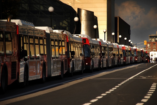
Consequences of investing in bus-based “rapid transit” (BRT) can be seen in Ottawa, where bus bunching and huge bus jams like this one reveal massive size of fleet necessary to support “rapid transit” levels of ridership — ridership far more efficiently accommodated by urban rail. Similar plans for expanded BRT infrastructure in Austin pose need for light rail transit (LRT) alternative. Photo: Flickr.
♦
By Dave Dobbs
Dave Dobbs is publisher of LightRailNow.com. This commentary has been adapted and expanded from original private Email comments.
Recent developments in local metro area transportation planning, particularly in the aftermath of last November’s ill-conceived “urban rail” bond vote debacle, have made it evident to some of us that there’s a need for a grassroots collection of stakeholders to unite behind a new urban rail planning process, and getting it started ASAP. This is more urgent than most people realize.
It’s abundantly clear that, over the past several years, Project Connect and CAMPO planners and officials have been aiming toward “forced busing” on Austin’s best potential light rail routes, the heavy local travel routes where currently the big red MetroRapid buses run — Guadalupe/North Lamar, South Congress, and South Lamar. As I pointed out in an earlier article on this issue («No urban rail on Guadalupe-Lamar? Then get ready for bus lanes…»), it’s ironic that, for the past several years, while some public officials have piously insisted we can’t possibly convert car travel lanes to reserved rail lanes on Guadalupe/North Lamar, it seems that all along, since at least 2012, this has been in planning for MetroRapid — in effect, a “stealth” plan for incremental BRT.

CAMPO 2040 plan includes hundreds of millions of dollars in proposed “BRT” projects, including plans to construct dedicated lanes in Guadalupe-Lamar corridor in lieu of light rail. Screenshot of Urban Transit page: ARN. (Click to enlarge.)
If, this coming May, the CAMPO 2040 plan is adopted with the Urban Transit Projects (2020 – 2040) currently in the plan, Capital Metro, perhaps together with the City, will have the green light to immediately pursue federal funding for concrete bus lanes on the above thoroughfares. And they will no doubt do so, as the 80% federal matching funds for buses are far more available than 50% federal matching funds for rail. Yet, even with the heavier federal proportion, this would be a disastrous waste in the longer term, since the ridership attractiveness, cost efficiency, more livable urban environment, stimulus for transit oriented development (TOD) and economic development, and other benefits for the community, far outweigh the advantage of a higher rate of federal bus system funding.
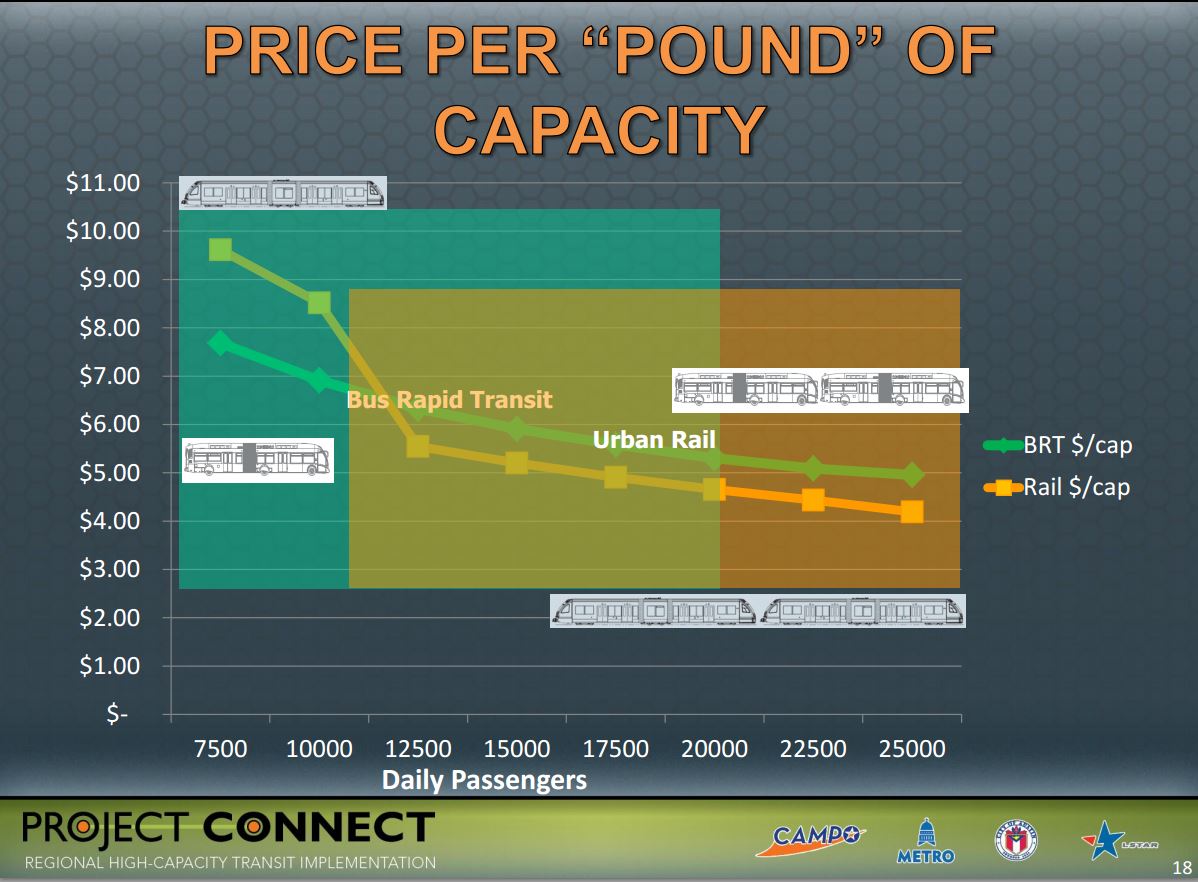
Project Connect graph, presented in June 2012 to Transit Working Group, showed greater cost-effectiveness of urban rail (LRT) compared with BRT, as ridership increases. Screenshot: ARN. (Click to enlarge.)
We should expect that the MetroRapid bus lane process will be similar to the Project Connect rail public process — i.e., art gallery open houses, boards and commission hearings and approvals, and finally, council and Capital Metro board approval … but no general public vote, because the the local 20% match will be small enough to construct discrete sections and can probably be found in a slush fund someplace. While 20% of the overall $442,861,656 Capital Metro has identified for dedicated MetroRapid bus lanes is around $88.6 million, it’s logical to expect a piecemeal approach, one section at a time, so as to avoid a citywide response over the loss of vehicle travel lanes. Divide and conquer.
For example, after having paint-striped a little over a mile of Guadalupe and Lavaca between Cesar Chavez and MLK, the most likely next step is to convert two vehicle travel lanes on Guadalupe from MLK to the Triangle (North Lamar at Guadalupe), a distance of 2.5 miles, for about $60 million. Of this, Austin’s share would be roughly $12 million, small enough to be found in current budget funds without going to the voters. Perhaps an even shorter segment, 1.5 miles to 38th Street, would be considered, where the local share would be only about $7 million.
While the downtown Guadalupe/Lavaca paint striping cost $270,000/mile, the dedicated lanes called for in the CAMPO 2040 plan are tear-up-the-street, fix-utilities, and pour 18 inches of concrete (very much like installing light-rail-dedicated reserved lanes) and cost about $24 million/mile for a lane in each direction. Of course, once the bus lanes are in, we couldn’t change our minds because (1) we’ll have spent a lot of federal dollars, and switching over to rail anytime soon would not get a hearing from the Federal Transit Administration (FTA), and (2) merchants and residents are not going to easily, willingly, or peacefully suffer urban street surgery twice. Currently the $38 million in Federal grants for MetroRapid in mixed traffic is mostly portable to another corridor (like Riverside, where it would be appropriate), and after seven years, buses are mostly amortized in the eyes of the FTA. Exclusive bus lanes at $350 million is another matter entirely, for something that can’t be moved.
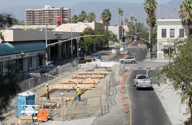
Construction for dedicated bus lanes, rarely shown by “BRT” promoters, is very similar to that for LRT, as this example from San Bernardino demonstrates. Yet effective capacity, ridership attraction, cost-effectiveness, TOD, and other benefits typically fall short of what LRT achieves. Photo: Omnitrans.org. (Click to enlarge.)
Proceeding with major investment in bus infrastructure in Guadalupe-Lamar and other high-travel local corridors is a huge mistake. As I warned in the earlier article cited above, if you would prefer urban rail instead of a major dedicated bus lane project in Guadalupe-Lamar, “it’s essential to speak up and act. Let neighborhood groups and other community organizations know what official plans have in store for this corridor.” It’s also important to communicate to local agencies involved with planning and members of the Austin City Council “that you want to ride urban rail on Guadalupe-Lamar, running in reserved tracks, not just a souped-up bus service weaving in and out of special lanes.” ■


Require that the bus lanes be rail ready. Require 15 inch high platforms at least 100 feet long and that any new pavement have rails done right. Use federal money only for those things that can be reused in an upgrade to rail such as the platforms, Note that bus and rail can share in an interim situation (Seattle bus tunnel and the Pittsburgh Mount Washington tunnel). Look at tactics that can result in bus being a true precursor to light rail including designing the system for easy upgrade. If they balk push back and make the opposition look like they are obstructionists..
I live in Ottawa and I am a transportation planner and I will tell you as your BRT system carries more passengers the greater the difficulty and cost to convert to any type of rail system. A considerable amount of time and effort to convert our Central Transitway (Transitway is the marketing name of the Busway system in Ottawa) to LRT is just in widening parallel rights of way to accommodate all the buses that use the system each day. At peak 185-200 buses per hour per direction use the Central Transitway. These temporary rights of way will be used until the conversion to LRT is complete and the system opens in 2018. The planning required a highway widening project, (Provincial HWY. 417, also known as the Queensway), the widening of Albert and Scott St. as well as the realignment of Nicholas St. leading into downtown Ottawa to be undertaken before most of the really heavy LRT construction forced the end of the bus only right of way. This added a considerable planning and engineering lag in the building of the project and probably added at the least 1 year to the LRT project timeline.
Keep in mind the Transitway was designed to be “converted to rail in the future” but, by the time that conversion occurred many of the station platforms were too small for the needed LRT vehicles and needed to be expanded. The rights of way were for the most part ok, in the slope of the right of way and long slight curves that were very rail friendly but, there were sections that have to be completely rebuilt because they were only temporary back in 1980’s and 90’s when most of the system was built. These temporary sections became permanent and were never upgraded to be rail friendly until the LRT conversion forced the redesign. Ironically, the section requiring the biggest new portion to be built is the portion that will include the Trembley Rd. station, in front of the city’s current intercity railway station, the 40+ year old “New Union Station”.
Another enormous section in phase 2 of the project will be the right of way that will replace the currently used but only temporary ( in use for 32 years) Western or Sir John A McDonald Parkway. There was much public controversy and some very intense talks between the City of Ottawa and the NCC (National Capital Commission) that actually owns most of the area’s Parkway System. There finally seems to be an agreement on the 32 year old temporary Transitway right of way for now. The actual infrastructure in the stations and on the right of way in most parts the LRT project, are already now 30+ years old and required complete replacement. Things like bridges and concrete retaining walls were in need or soon would be in need of replacement, this added greatly to the cost of the project.
Even in Seattle, the whole thing had to basically be rebuilt, so I wouldn’t use them as a good example either.