
Project Connect admits major data error in Guadalupe-Lamar corridor study
27 October 2013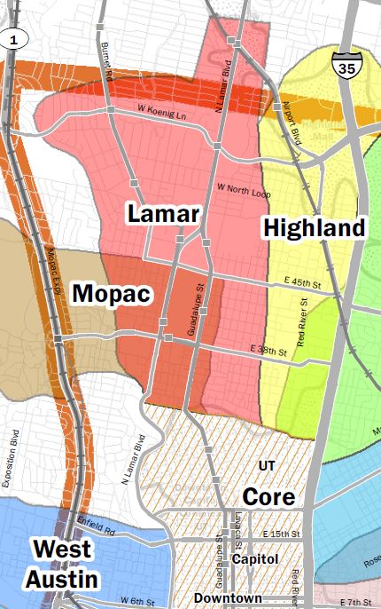
Snippet of Project Connect’s much larger “Central Corridor” map (actually, the central-city study area) shows “Lamar” sector (in orange, dubbed a “sub-corridor” in Project Connect’s peculiar nomenclature) plus several adjacent sectors. Actual Guadalupe-Lamar travel corridor includes both the Lamar and Core sectors, but each sector is being evaluated in isolation.
♦
The Project Connect urban rail planning team has been conducting a nominal study of designated alternative “sub-corridors” for urban rail (they’re actually not “corridors”, but sectors of the central-city study area). In the process, the agency has been compiling purported data (covering key indicators for each “corridor”, or study sector, such as population, density, transit ridership, etc.) in a series of so-called Map Books (each one an update of the previous one).
Meanwhile, tirelessly and tediously scrutinizing each volume of Map Book data has been the self-appointed task of Scott Morris, head of the Central Austin Community Development Corporation (CACDC), which, together with Texas Association for Public Transportation, has been advancing the case for the Guadalupe-Lamar travel corridor as the most effective alignment for Austin’s proposed urban rail starter line. Scott has performed amazingly detailed and well-supported research into these data issues, and he has found and pointed to a lengthy array of dozens of mostly serious errors. A handful of these have been quietly rectified.
One of the most serious data anomalies that Scott has recently detected is the “disappearance” of virtually all the ridership for Capital Metro’s routes #1M/L and #101, the heaviest-ridership transit routes in the system, serving the G-L corridor as well as South Congress. This was cited in a listing of nearly three dozen data problems submitted by CACDC to the Project Connect urban rail study team:
v4 Comment 29 High
Pages 36-37 Bus Ridership 2011
According to the 2020 service plan in January 2010, the #1 North Lamar and the #101 had over 17,000 daily boardings combined. But, this chart seems to omit nearly all boardings for the Guadalupe-North Lamar Corridor.
At last, Project Connect has publicly admitted at least one of the numerous errors that have been published in the series of Map Books. Responding mainly to criticism by Jace Deloney, one of the leaders of Austinites for Urban Rail Action (AURA, which supports a transparent, open, and fair route evaluation process), on October 22nd Project Connect issued a statement acknowledging the erroneous ridership data, which it says resulted from “populating” the map (data visualization graphic) with the “wrong data field”. A screen capture of the statement is shown below.
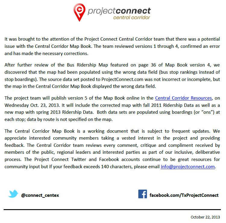
Project Connect statement admits major error in transit ridership data for Guadalupe-Lamar corridor.
Data errors, in particular large ones like this, are especially serious because the selection of a “corridor” (actually, a sector of the huge central-city study area) depends critically on key data factors, including existing transit ridership in a given corridor.


[…] there was the time Project Connect presented bus ridership data with completely wrong numbers, because they selected the wrong data set, which resulted in a map that was exactly the opposite of […]