Republic Square station would provide southwest sector of downtown 4-5 minute connectivity to light rail as illustrated by red lines. Graphic: ARN, adapted from original DAA map.
By Lyndon Henry, Editor
Why are urban rail stations in downtowns – central business districts (CBDs) – typically spaced so much more closely than in outlying stretches of rail lines? Of course, one major reason is that more frequent stations are needed to serve the density of these highly compacted activity concentrations – employment density in particular, although population density in city centers, like Austin’s, has also been increasing.
Commuters to downtown jobs will tolerate a longer walk to an outlying light rail transit (LRT) station, or even access of a mile or more to a park & ride. But over a century of experience has shown that most people don’t want to spend much above about five minutes walking to their workplace from their transit stop. Or from their workplace to the nearest transit station, to commute home at the end of a day’s work.
To some extent, in Austin Rail Now’s previous post, these factors are reflected in the map-graphic shown (originally prepared by the Downtown Austin Alliance (DAA) and included in a public document by the Austin Transit Partnership). Using shaded circular areas around several proposed downtown LRT stations, the graphic illustrates a quarter-mile/five-minute walk distance around each station. While the DAA’s graphic bolsters the case for adding a Wooldridge Square station to the LRT plan (an addition we strongly support), it also exposes a large gap in coverage for the southwest segment of downtown.
Republic Square station fills need
This gap can be filled by a Republic Square station (between W. 4th and 5th Streets), as shown in the graphic above (at the head of this article), which we’ve adapted from the DAA map. On our graphic, red lines radiating westward from the proposed station indicate approximate 4 to 5-minute walk distances to points in this area. Southwest downtown includes such major sites as the Federal Courthouse, the Seaholm development (with various shops and restaurants), the Austin Central Library, and several large condo and apartment highrises. The district also includes a multitude of other establishments, such as smaller shops, hotels, restaurants, and more. A Republic Square LRT station would also be just six blocks from the major westside Whole Foods Market.
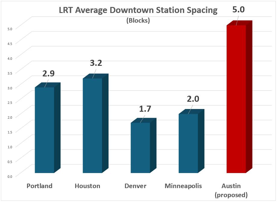
The need for another downtown station (in addition to stations already proposed by the Project Connect team and the DAA’s Wooldridge Square concept) is highlighted in the following graph comparison of station spacing. This uses roughly equivalent block lengths in several peer cities (considered quite successful in the industry); the data used for Austin includes the proposed Wooldridge Square station, which Project Connect considers an “option”. This comparison suggests that the downtown station spacing so far proposed for Austin’s coming LRT system seems inconsistent with Best Practices by these typical peer systems.
Even with “optional” Wooldridge station, proposed spacing of Austin’s downtown LRT stops appears to violate Best Practices of several peer city systems. Graphic: ARN.
Easy Interface with current transit hub
In addition to ease of access, another factor typically involved in the layout and spacing of downtown stations is the need to minimize peak crowding and to avoid overcrowding at any station in these high-population areas. Providing too few stations in these situations (which may be indicated by longer stop-spacing) can create excessive crowding that is unpleasant, dangerous, and disruptive to smooth operation and service.
And in regard to the proposed Republic Square station specifically, there’s another major consideration: the opportunity for LRT to interface with the major bus transit hub at Republic Square, which has functioned for years to provide a relatively smooth interface among routes, well-known to the public.
In artistic simulation, a light rail train rolls through Republic Square – but without a station! Graphic: Austin Transit Partnership.
Not only is the Republic Square hub well-established and familiar to the transit-riding community, it’s positioned six blocks (along 4th St.) from the downtown MetroRail station at the Austin Convention Center, providing a feasible interconnection between MetroRail and the large assortment of bus routes converging at Republic Square. Adding an LRT station here would expand Republic Square’s role into a multi-modal transit hub.
For multiple reasons, a Republic Square station would fill a critical need and eliminate the remaining serious gap in the proposed downtown LRT alignment. But if this gap were to remain in the final plan, we can’t help imagining whether future generations of Austinites will be wondering: “What were they thinking?” And it’s critical to keep in mind here that retrofitting an urban rail station into an existing alignment – particularly in an intensively developed central-city environment – is far more expensive than including it in the original construction project. ■
Wooldridge Square Station proposed by DAA, showing connectivity benefits. Source: DAA via Austin Transit Partnership.
By Lyndon Henry, Editor
In my December 18thARN article, “Downtown Light Rail Plan Needs More Stations”, I explained the need to include additional downtown stations in Project Connect’s revised surface-routed light rail transit (LRT) plan, and specifically recommended adding stations on the Guadalupe St. alignment at Republic Square (W. 4th St.) and W. 10th St. (Wooldridge Square). As I noted, these proposals were developed via my discussions in the previous spring and summer of 2023 with ATP staff and technical advisory committee members; they were eventually presented in a June memo.
As it turns out, the Downtown Austin Alliance (DAA, a consortium of downtown businesses, real estate interests, developers, and related interests) had also perceived the need for at least one additional station – at Wooldridge Square, just as I have also recommended – and included a proposal for such within a memo dated 10 May 2023 to Austin Transit Partnership (ATP) Executive Director Greg Canally. (This is contained in ATP’s Austin Light Rail: Community Engagement Report, a document released publicly in May 2023.)
The Wooldridge Square Station proposal is shown in a graphic map appendix, labeled “Wooldridge Station Connectivity”, illustrating the additional coverage that the station would provide within a ¼-mile radius, and sites of key interest made more accessible by such a station (this is the head map-graphic at top of this post).
As I had pointed out in my own June 2023 memo, Project Connect’s revised plan for downtown was proposing “exceptionally long spacing between stations for a major dense central area, and I believe it is inconsistent with Best Practices ….” DAA’s memo seems to provide some corroboration for this assessment, while emphasizing the enhanced accessibility provided by a Wooldridge Square station:
As currently proposed, the distance between the Congress and 15th Street stations is approximately one mile. We recommend adding an additional station in the vicinity of Wooldridge Square and Sweatt Travis County Courthouse. This would lessen the distance between the Congress and 15th Street stations to less than half a mile and would provide much needed access to courthouses (federal and state), Austin Community College, Pease School redevelopment, Austin History Center, the Paramount and the Old Bakery. It would also facilitate east-west transfers to frequent bus routes at 7th/8th Streets, providing potential congestion relief at Republic Square.
For sure, DAA’s proposal to add a Wooldridge Station represents an important and crucial improvement for the planned downtown LRT alignment. So far, Project Connect and Austin Transit Partnership have presented this as a possible design “option”. Hopefully this will be accepted as a definite element of the plan.
But a Republic Square station is also essential for adequate connectivity and accessibility in Austin’s downtown. The case for this will be presented in a subsequent analysis to be posted shortly. ■
Proposed alternative Orange Line alignment. Source: L. Henry (click on graphic to enlarge).
By Lyndon Henry
Lyndon Henry, an urban and transportation planner, is a technical consultant to the Light Rail Now Project of Texas Association for Public Transportation (a Texas nonprofit organization) and contributing editor to Austin Rail Now (ARN). He is also a member of the Engineering, Architecture and Construction (EAC) Advisory Committee of the Austin Transit Partnership (ATP), the public agency overseeing Austin’s major transit development program (including light rail) approved by city voters in November 2020.
In April 2022, Project Connect reported it was encountering a $4.5 billion budget overrun in its light rail transit (LRT) program, of which $3.9 billion was linked to the Orange Line and tunnel segments. In a May2022 memo to the EAC committee, Lyndon noted that much of this “appears to be a result of the extension of the subway tunnel under the river, the South Bank, and South Congress Avenue” (which had replaced an earlier conception of a surface alignment and bridge). As remedial measures, Lyndon offered proposals to consolidate the Orange and Blue lines into a single tunnel alignment through downtown and onto a single crossing, by bridge, over the Colorado River (Lady Bird Lake). These ideas are being considered by the Project Connect team as possible design alternatives.
In an effort to contribute to the “criteria evaluation and project optimization” goals of a 22 October Light Rail Workshop of several ATP advisory groups, including the EAC, Lyndon submitted a handout proposing his tunnel and bridge consolidation plan plus suggesting a redesign of the South Congress light rail extension as a surface alignment, “avoiding the heavy cost of a subway tunnel in this segment.” These ideas “appear to offer potential to reduce cost and speed up construction, helping to fulfill what voters have approved” he noted, adding that “Hopefully, at least a portion of the proposed extension into Central South Austin might be completed per the original schedule.” The below presents the proposals in that workshop handout.
With serious potential budget overruns posed by the transit system plan designs to date, the Project Connect team has been seeking ideas for alterations and alternatives. Here are some of my own thoughts and proposals toward “criteria evaluation and project optimization” as requested in this workshop.
Securing public trust
A major premise of my approach, based on 50 years of involvement and research in public transportation, is that maintaining public trust is absolutely crucial to a project of this importance and magnitude.
Public expectations should be highly valued. Accordingly, my proposals are intended to maintain as much of the original light rail transit (LRT) route structure and completion schedule as possible, remaining faithful to what voters have approved. Given the budget problems and constraints that have emerged, this seems to imply some major changes to plan configurations, particularly infrastructure design, to reduce budgetary investment cost and minimize construction time.
Downtown subway reconfiguration
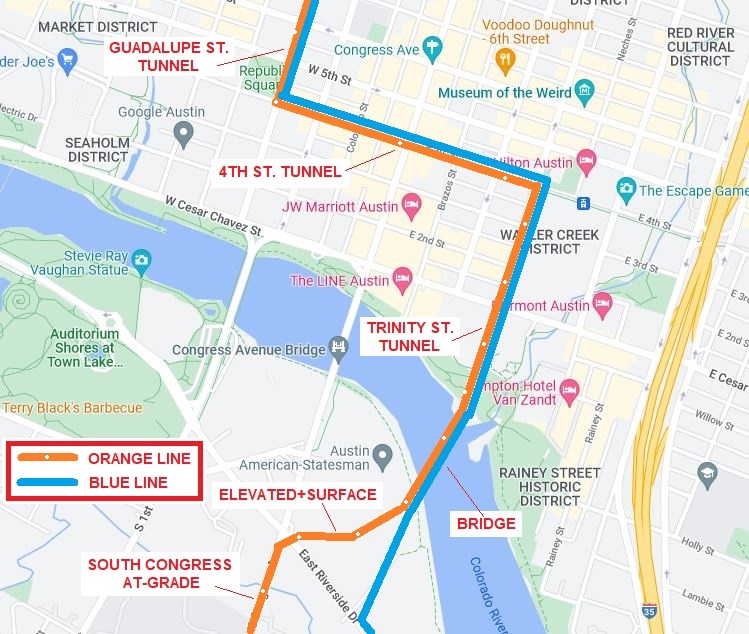
In the map [shown above] (originally presented to the EAC Advisory Committee in May), I have proposed an alternative alignment for the Orange Line southward from Republic Square, eliminating the currently proposed tunnel under the river to the South Bank and into South Congress Avenue. Instead, from Republic Square southward the Orange Line would follow the Blue Line alignment via the 4th St. tunnel, then the Trinity tunnel. Emerging just north of the Colorado River, the Orange Line would then share the proposed bridge over to the South Bank.
On the South Bank, the Orange Line would branch westward via available real estate and Riverside Drive right-of-way over to South Congress Avenue (a station could be installed in this area to provide approximately 0.4-mile access to Auditorium Shores and the Long Center). Sharing the Blue Line alignment via 4th St./Trinity St. and the proposed transit bridge as an alternative connection from downtown to the South Bank would alone reduce investment cost significantly (perhaps by $1 billion or more). The Orange Line could then proceed into the South Congress corridor either in tunnel or as a surface alignment.
South Congress surface alignment
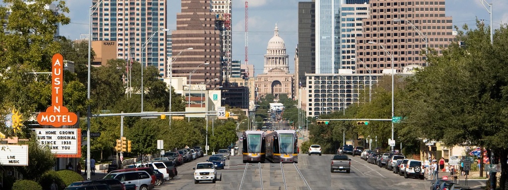
A surface alignment on South Congress Avenue (as proposed in the original conception of this LRT project) in lieu of tunnelling would offer another means of substantial construction cost and time saving and likely facilitate at least some of the previously proposed extension of the Orange Line into Central South Austin by 2029. Perhaps the widest local arterial in the central city, South Congress offers a virtually ideal opportunity for surface light rail. (See graphic simulation, below.)
Construction of surface facilities (e.g., stations, overhead contact system) should be possible within the Capitol View Corridors (CVC) regulatory guidelines at least as far south as Mary Street. (As defined by the Downtown Commission in a 2007 document, “A view corridor is a plane that extends from a defined view point or points to the base of the Capitol dome. … No structure is permitted to pierce the plane.”) To avoid obstructing the CVC in the remaining short segment from Mary to south of Live Oak St., trains could operate on batteries or perhaps a technology such as Alstom’s proprietary APS (alimentation par sol – ground power) electrification system, which uses a surface power strip between the rails which is electrified only when a train is passing on that section of track.
Simulation of surface light rail alignment on South Congress (courtesy George Barsky)
Rethinking intersection with Cesar Chavez St.
So far, design of LRT alignments downtown has been constrained by the assumption that Cesar Chavez St. with its heavy traffic flow cannot tolerate the interruptions from a surface intersection with light rail. However, LRT lines in various other cities have worked well for decades with surface intersections with similar major arterials (e.g., Portland’s original MAX LRT line has crossed the city’s major 5th and 6th Avenues downtown since 1986). Elimination of this constraint, thus permitting LRT surface crossings of Cesar Chavez, could provide Project Connect greater planning flexibility and lead to even more substantial cost savings. ■
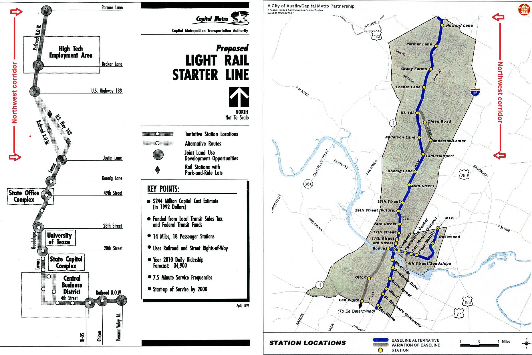
Map shows Red Line and proposed Green Line. Red Line north and west of Crestview station serves metro area’s northwest corridor, currently operated with diesel “urban commuter rail” technology. Conversion to electric light rail and inclusion in new LRT system would provide major advantages. Source: CMTA (click on graphic to enlarge).
By Lyndon Henry
Lyndon Henry, an urban and transportation planner, is a technical consultant to the Light Rail Now Project of Texas Association for Public Transportation and contributing editor to Austin Rail Now (ARN).
Capital Metro, Project Connect, and the Austin Transit Partnership seem to be heading toward a serious and expensive mistake, ultimately with longterm adverse consequences: setting in concrete and steel the exclusion of the metro area’s northwest corridor and Red Line from Austin’s new electric light rail transit (LRT) system. It’s a decision currently in planning and at “only” 15% of design, but the eventual results could include suppressing potential ridership, raising ongoing operating costs significantly, and locking in place a two-tier rail transit operation of two different technologies requiring separate but duplicative facilities to serve similar segments of the metro population.
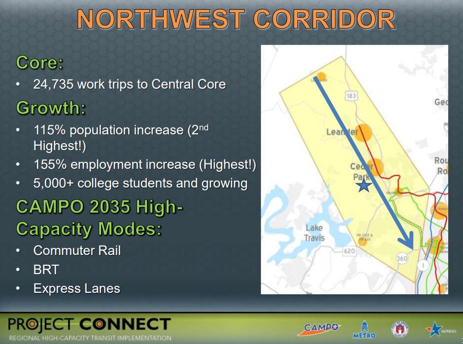
The northwest corridor – generally centered along the US 183 highway and 183A tollway, and also served by the Red Line “commuter rail” transit service to Leander – comprises metro Austin’s second-heaviest growth and travel corridor, after I-35. With density averaging more than 6100 persons per square mile, this corridor includes the City of Austin’s rapidly densifying northwestern suburban neighborhoods as well as the fast-growing suburban cities of Cedar Park and Leander. A member of Capital Metro’s service area since the agency’s inception, in 2020 Leander was described as an “Austin area suburb named as fastest growing city in America”. [Austin Business Journal, 26 July 2020]
“Urban commuter rail” substituted for light rail
From the 1970s, the railway line to Leander was envisioned as a crucial branch of a future LRT system, and as such was included in Capital Metro’s official light plans in the 1990s and early 2000s. However, to install a rail transit operation quickly, the MetroRail DMU (diesel multiple-unit) service, characterized as “urban commuter rail”, was conceived as an interim replacement, and approved by voters as part of the All Systems Go program in 2004.
At that time, the diesel-powered, bare-bones, lower-capacity, mostly single-track approach seemed an affordable, lower-risk way to get a minimalist rail transit operation up and running – in effect, a “demonstration line” allowing the metro Austin public to experience rail transit in their community, and to enable transit planners to assess community response. Unfortunately, current plans appear to perceive the “urban commuter rail” system – both the operating Red Line and new Green Line – as a permanently separate system, distinct from the electric LRT system now being implemented in central-city Austin.
Project Connect presentation in 2012 to Transit Working Group emphasized extraordinary demographic growth and ridership potential of northwest corridor. Source: Project Connect, TWG (click on graphic to enlarge).
Advantages of LRT for northwest corridor
Why is this such an unfortunate policy? Mainly because “commuter” rail (regional passenger rail) is a far less efficient and cost-effective mode than electric LRT for this kind of rapidly developing and densifying urban-suburban corridor. Here are some of LRT’s strongest advantages for Austin’s northwest corridor:
►Faster, more frequent service — LRT’s high-power electric rolling stock, with higher acceleration/deceleration rates, would be able to provide faster, much more frequent service and thus substantially higher capacity for journeys within this major travel corridor to and from Austin’s central area.
►Seamless connections — By interlining with the Orange and Blue LRT lines, LRT would offer a convenient, comfortable, “seamless” journey – without the need for a transfer – to northwest corridor passengers traveling to and from major destinations such as the University of Texas West Campus area, the Capitol Complex, the heart of downtown, and the ABIA aiport.
►Significantly higher ridership — Faster, seamlessly direct rail transit service between the northwest corridor, the major activity centers within Austin’s core, and ABIA should itself stimulate a significant increase in ridership. The higher performance features of LRT could make additional stations in the corridor more feasible, adding a further boost in ridership.
►Enhanced TOD potential — The availability of a fast, seamless, direct rail connection to Austin’s core and ABIA can be expected to further enhance the attraction of northwest corridor station sites for transit-oriented development (TOD). This in turn would likely create its own additional stimulus to ridership.
►Lower operating costs — On average, the operating & maintenance (O&M) costs of LRT per passenger-mile (p-m) amount to just 34% of those of DMU “light commuter” operations of the same type as Capital Metro’s MetroRail. Put another way, MetroRail DMU operation costs about 3X as much per p-m as LRT. To take some examples from the most recent National Transit Database report (2019) by the Federal Transit Administration, Capital Metro’s Red Line service costs $1.73 per p-m compared to $0.85 for Dallas’s DART LRT system, $0.80 for Portland’s MAX, $0.39 for San Diego’s Trolley.
►Elimination of duplicative service — Current planning seems to envision two permanently separate transit systems/technologies, with duplicate rolling-stock fleets, service facilities, etc., to serve corridors with basically very similar demographics within the same urbanized area. This seems inherently wasteful and unnecessary. Unifying these separate operations could further reduce costs by both eliminating duplication and facilitating economies of scale in procurements.
►More flexible alignment opportunities — Unlike MetroRail’s “heavy” railroad rolling stock, LRT trains can turn street corners and run in city streets, as needed, compatibly with motor vehicle traffic. This would make possible, say, a simple crosstown rail transit connection between the Convention Center station and the Seaholm development area.
►Compatibility with freight rail — Capital Metro’s privately contracted freight rail operation is currently an important revenue source for the agency; in addition, by reducing motor truck traffic on metro area roadways, it provides a net environmental benefit. MetroRail passenger service currently shares these tracks with freight via temporal (time) separation (freight operations run late at night, leaving the tracks free for transit service from morning to evening). LRT could operate likewise. LRT operations elsewhere also provide models and precedents for this: the San Diego Trolley (since 1981) and Salt Lake City Trax (since 1999) have successfully and safely shared tracks with freight railroad services for decades.
Service in northwest corridor (marked with red arrows on these maps) was proposed in past LRT plans developed by Capital Metro. LEFT: 1993 plan. RIGHT: 2000 plan. Source: CMTA (click on graphic to enlarge).
Unifying MetroRail and LRT
A unified system, with electric LRT service out to Leander, would not only serve one of the heaviest-traffic and fastest-growth corridors in the city with a proper high-capacity rapid transit-type operation, but would also, as noted above, enable an uninterrupted one-seat ride from Leander and other points along the Red Line corridor straight to UT, the Capitol Complex, and the heart of downtown. Making this a northwest extension of the planned Blue Line LRT would also incorporate a direct connection to ABIA. The Red Line service, from Leander to ACC’s Highland campus, through East Austin, and into the lower east side of downtown, could also be maintained with LRT.
Converting the MetroRail Red Line to electric LRT, and incorporating a connection in the grade-separation already being planned at Crestview, would be a relatively moderate-cost project, much less than building a new line from scratch. On average, using and modifying an existing railway alignment provide by far the lowest-cost type of LRT line construction. Planning for an integrated LRT system including the northwest line to Leander would need planning for both design and funding.
In terms of design, two engineering features are necessary:
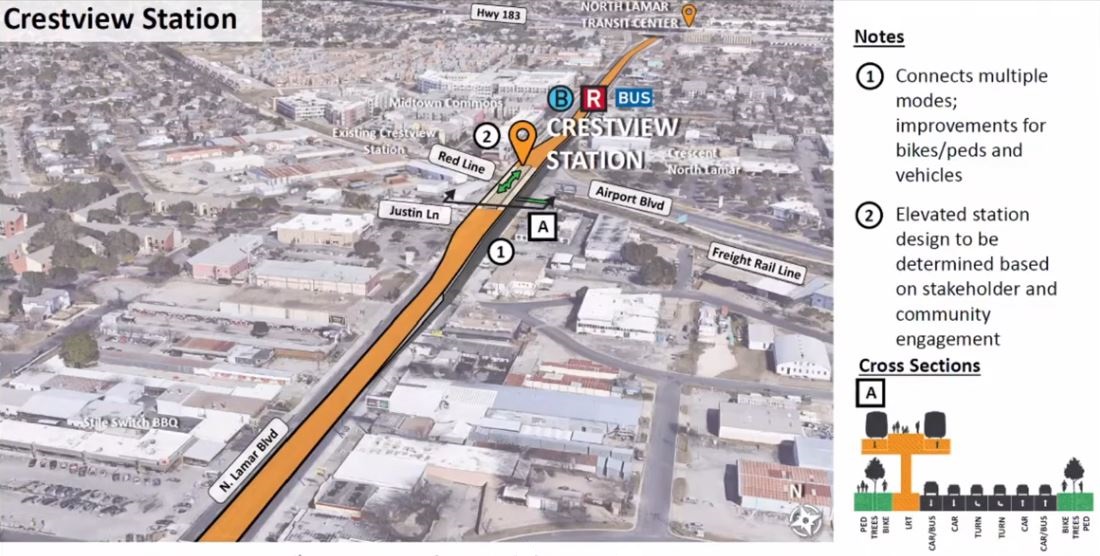
• Plans for the grade-separated interchange at Crestview (N. Lamar/Airport Blvd.) would need to be modified to include a future track junction to enable northwest-corridor trains to join and interline with the Orange/Blue Line tracks on North Lamar. As currently planned, both rail alignments would be separated from the North Lamar roadway lanes; but a total grade separation is also planned between the existing railway (Red Line, which would tunnel under the intersection), and Project Connect’s proposed LRT alignment (which would fly over the intersection on a viaduct). This would force a cumbersome transfer for all LRT passengers traveling to or from the northwest and points south. A track junction would facilitate interlining and enable the seamless, transfer-free ride described earlier.
Diagram illustrates current design (15% complete) of future Orange Line LRT entering elevated alignment on North Lamar at Crestview, with Red Line totally grade-separated and crossing below LRT in tunnel (freight track would remain at-grade). To link northwest corridor into LRT system, this design must be modified to include track junction between Red Line and Orange Line. Graphic: Project Connect (click to enlarge).
• LRT system rail and vehicle wheel profiles that conform with railroad specifications would need to be designed and selected (i.e., the rails and car wheel profiles for the new LRT system would need to match those currently in use for the Red Line). This is standard for transit systems that include track-sharing with heavy railroad operation.
However, it must be realized that Project Connect’s planners are moving quickly toward finalizing a two-tier separated MetroRail and LRT dichotomy permanently in their final design, now 15% completed in late 2021 and expected to be 30% completed in the spring of 2022. Unless that design is tweaked to include the unification and compatibility measures described in this report, residents in the northwest corridor, including Leander, would likely never have that one-seat ride to UT, the Capitol, and ABIA, and Capital Metro’s rail transit services would be burdened with higher-than-necessary O&M costs.
The inclusion of the northwest corridor, and conversion of the Red Line to LRT, are not part of the large Project Connect transit program approved by voters in November 2020 and now underway. These plan changes would need to be approved, funded, and undertaken as a future separate project. This would include negotiating for and receiving a track-sharing waiver from the Federal Railroad Administration (as was done in San Diego and Salt Lake City). But surely the multiple benefits and substantial cost savings justify investing the effort and resources to achieve a unified regional LRT system for metro Austin. ■
You are currently browsing the archives for the Project Connect light rail project category.
What We’re Seeking
• Development and expansion of an attractive, cost-effective multi-modal light rail and regional passenger rail transit system throughout the Austin metro area
• Improvement and expansion of Amtrak intercity rail passenger service
• Development of regional rail passenger service connecting metro Austin with other communities